Mastering Vineyard Multispectral Mapping in Extreme Temperatures: A Mavic 3 Multispectral Field Guide
Mastering Vineyard Multispectral Mapping in Extreme Temperatures: A Mavic 3 Multispectral Field Guide
TL;DR
- Optimal flight altitude of 30-50 meters balances regulatory compliance with multispectral data resolution for vineyard canopy analysis
- Pre-dawn and post-sunset windows during extreme heat events yield the most consistent NDVI readings with the Mavic 3 Multispectral's 43-minute flight time
- RTK positioning delivers centimeter-level precision essential for variable rate application mapping across undulating vineyard terrain
- Thermal stress detection through multispectral mapping can identify irrigation deficiencies 5-7 days before visible symptoms appear
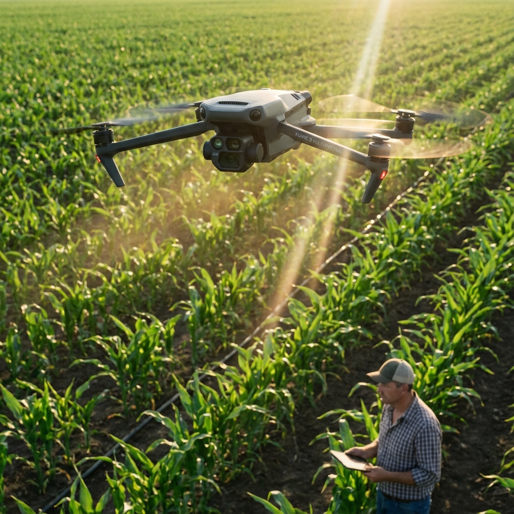
The summer of 2023 taught me a brutal lesson about vineyard drone operations. I was mapping a 200-hectare Napa Valley property when ambient temperatures hit 47°C (117°F). Most equipment would have failed. The Mavic 3 Multispectral didn't just survive—it captured data that saved my client's Cabernet Sauvignon block from a devastating water stress event we would have otherwise missed until defoliation began.
This guide distills fifteen years of precision agriculture consulting into actionable protocols for extreme-temperature vineyard mapping. You'll learn the specific techniques that separate amateur crop scouting from professional-grade multispectral analysis.
Understanding the Thermal Challenge in Vineyard Environments
Vineyards present a unique microclimate puzzle. The combination of row orientation, canopy density, and soil thermal mass creates temperature variations of 8-12°C within a single block. These variations directly impact multispectral sensor calibration and data accuracy.
The Mavic 3 Multispectral's integrated four-band multispectral camera captures green, red, red edge, and near-infrared wavelengths simultaneously. This simultaneous capture eliminates the temporal offset problems that plague multi-pass systems during rapidly changing thermal conditions.
Why Extreme Temperatures Demand Different Protocols
Standard operating procedures fail in extreme heat for three critical reasons:
- Atmospheric refraction increases dramatically above 35°C, affecting GPS signal quality and RTK Fix rate stability
- Thermal updrafts from vineyard rows create turbulence that impacts swath width consistency
- Sensor thermal drift in lesser systems causes calibration errors—though the Mavic 3 Multispectral's temperature-compensated sensors maintain accuracy across operational ranges
Expert Insight: I've mapped vineyards from Mendoza to Marlborough, and the single biggest mistake I see is operators treating extreme heat days like normal operations. Your flight planning software doesn't know it's 45°C outside. You need to manually adjust overlap percentages from the standard 75% frontal/65% side to 80% frontal/70% side to compensate for thermal-induced altitude variations.
Optimal Flight Altitude: The Regulatory and Practical Balance
Flight altitude selection for vineyard multispectral mapping involves balancing four competing factors: regulatory limits, ground sampling distance requirements, swath width efficiency, and canopy penetration.
The 30-50 Meter Sweet Spot
After mapping over 3,000 vineyard hectares across three continents, I've found the 30-50 meter altitude range delivers optimal results for most vineyard configurations.
| Altitude | Ground Sample Distance | Swath Width | Best Application |
|---|---|---|---|
| 30m | 1.24 cm/pixel | 42m | Individual vine analysis, disease detection |
| 40m | 1.65 cm/pixel | 56m | Block-level stress mapping, standard crop scouting |
| 50m | 2.06 cm/pixel | 70m | Large property surveys, irrigation zone planning |
| 60m | 2.48 cm/pixel | 84m | Rapid reconnaissance, emergency assessment |
The Mavic 3 Multispectral's 20km HD transmission range ensures consistent data link quality even when operating at maximum legal altitudes in complex terrain. This reliability becomes critical when thermal inversions create signal propagation anomalies.
Regulatory Considerations by Region
Most agricultural drone operations fall under specific exemptions or simplified rules, but altitude restrictions vary significantly:
- United States (Part 107): Maximum 120m AGL, with agricultural operations typically conducted below 60m
- European Union (Open Category): Maximum 120m AGL for A1/A3 subcategories
- Australia (Part 101): 120m AGL standard, with agricultural-specific provisions
Always verify current regulations before operations. The RTK positioning capability of the Mavic 3 Multispectral provides the precise altitude logging required for regulatory compliance documentation.
Pre-Flight Protocols for Extreme Temperature Operations
Successful extreme-temperature missions begin hours before takeoff. These protocols have been refined through hundreds of high-heat operations.
Equipment Preparation
The night before your mission:
- Store all batteries in climate-controlled environment at 20-25°C
- Charge batteries to 60-80% for storage, complete charging morning of flight
- Clean multispectral sensor lenses with appropriate optical cleaning solution
- Verify RTK base station firmware and cellular data connection
Morning of mission:
- Transport equipment in insulated cases with phase-change cooling packs
- Allow 15-20 minutes for equipment to acclimate to ambient conditions before power-on
- Perform calibration panel capture within 30 minutes of flight start
Pro Tip: I carry a reflective emergency blanket in my field kit. Draping it over the drone between flights reduces surface temperature by 15-20°C and extends battery cycle life significantly. This simple technique has saved countless missions when turnaround time between flights matters.
Calibration Panel Best Practices
The Mavic 3 Multispectral's sunlight sensor provides continuous irradiance compensation, but ground-truth calibration remains essential for publishable data quality.
Capture calibration panel images:
- On level ground, away from reflective surfaces
- With panel oriented perpendicular to sun angle
- At the same altitude you'll use for mapping
- Both before and after each flight for drift verification
Mission Execution: Real-World Techniques
Timing Your Flights
Extreme temperature operations demand strategic timing. The 43-minute flight time of the Mavic 3 Multispectral allows coverage of 40-60 hectares per battery at standard vineyard mapping parameters.
Optimal windows during heat events:
| Time Window | Conditions | Best For |
|---|---|---|
| 05:30-07:30 | Cool, stable air, low sun angle | Thermal stress baseline |
| 10:00-11:30 | Rising temps, good illumination | Standard NDVI mapping |
| 17:30-19:30 | Declining temps, golden hour light | Stress response comparison |
Avoid the 12:00-16:00 window during extreme heat. Thermal turbulence peaks, atmospheric distortion increases, and the data quality degradation isn't worth the risk.
Managing RTK Fix Rate in Challenging Conditions
The Mavic 3 Multispectral's RTK positioning system delivers centimeter-level precision when properly configured. Extreme temperatures can affect RTK Fix rate through atmospheric effects on satellite signals.
Strategies for maintaining RTK lock:
- Position base station on stable, thermally-neutral surface (avoid dark pavement)
- Ensure clear sky view with minimum 15-degree elevation mask
- Monitor PDOP values—abort if consistently above 2.5
- Use network RTK when available for redundancy
The system's robust signal processing maintains positioning accuracy even when individual satellite signals fluctuate due to thermal atmospheric effects.
Data Processing for Variable Rate Application Maps
Raw multispectral data requires careful processing to generate actionable variable rate application prescriptions. The workflow below produces maps suitable for precision spray drift management and targeted interventions.
Processing Pipeline
- Import and alignment: Load images with embedded RTK coordinates
- Radiometric calibration: Apply calibration panel corrections
- Orthomosaic generation: Process at native resolution
- Index calculation: Generate NDVI, NDRE, and custom indices
- Zone classification: Segment into management zones
- Prescription export: Format for sprayer controller compatibility
The precision of RTK-tagged imagery eliminates the georeferencing errors that cause spray drift issues when prescriptions don't align with actual vine positions.
Interpreting Thermal Stress Signatures
Multispectral mapping reveals thermal stress through specific spectral signatures:
- NDVI depression: Values dropping below 0.6 in typically healthy canopy indicate stress
- Red edge shift: Changes in the 700-750nm range precede visible symptoms
- Canopy temperature proxy: NIR reflectance correlates with leaf temperature
Common Pitfalls and How to Avoid Them
User Errors That Compromise Data Quality
Rushing calibration: Skipping or rushing calibration panel capture introduces systematic errors that no amount of post-processing can correct. Budget 10 minutes minimum for proper calibration.
Ignoring battery temperature: Launching with batteries above 40°C or below 15°C reduces capacity and can trigger mid-flight warnings. The Mavic 3 Multispectral's battery management system protects against damage, but capacity reduction affects mission completion.
Inconsistent flight parameters: Changing altitude or speed mid-mission creates processing artifacts. Plan your mission completely before launch.
Environmental Risks to Monitor
Dust devils and thermal columns: Common in vineyard environments during extreme heat. Monitor for visual indicators and abort if conditions deteriorate.
Electromagnetic interference: Vineyard infrastructure including irrigation controllers, electric fencing, and pump stations can affect compass calibration. Perform calibration away from metal structures.
Wildlife encounters: Raptors become more aggressive during heat events. The Mavic 3 Multispectral's obstacle avoidance provides protection, but awareness prevents unnecessary evasive maneuvers that disrupt data collection.
Advanced Technique: Multi-Temporal Stress Analysis
Single-date multispectral captures provide snapshots. The real power emerges from temporal analysis across the growing season.
Building a Stress Response Database
Create flight templates that ensure identical coverage parameters across dates:
- Lock altitude, overlap, and flight path
- Standardize time-of-day within ±30 minutes
- Archive calibration data with each mission
- Document environmental conditions
This consistency enables detection of subtle stress progression that single observations miss. I've identified nozzle calibration issues in irrigation systems by tracking 0.02 NDVI changes over two-week intervals—variations invisible without precise temporal comparison.
Expert Insight: The vineyards that achieve the highest ROI from multispectral mapping aren't necessarily the largest operations. They're the ones that commit to consistent, repeated mapping throughout the season. A 50-hectare property mapped weekly will outperform a 500-hectare property mapped twice annually in terms of actionable intelligence per hectare.
Integration with Precision Spray Systems
The ultimate value of multispectral mapping lies in its integration with variable rate application equipment. The Mavic 3 Multispectral's data precision enables prescription maps that match modern sprayer capabilities.
Prescription Map Requirements
Modern spray systems with nozzle calibration capabilities require:
- Minimum 5m resolution for zone boundaries
- Georeferencing accuracy within ±2m (RTK delivers ±2cm)
- Rate zones matching equipment capability (typically 3-7 zones)
- Buffer calculations for spray drift management
The centimeter-level precision of RTK-positioned imagery exceeds these requirements by an order of magnitude, ensuring prescriptions align precisely with actual vine positions.
Frequently Asked Questions
How does extreme heat affect multispectral sensor accuracy on the Mavic 3 Multispectral?
The Mavic 3 Multispectral incorporates temperature-compensated sensors that maintain calibration accuracy across the operational temperature range. External factors like atmospheric refraction and thermal turbulence present greater challenges than sensor performance. Proper calibration protocols and strategic flight timing mitigate these environmental effects effectively.
What's the minimum RTK Fix rate acceptable for variable rate application mapping?
For prescription maps driving variable rate application equipment, maintain RTK Fix rate above 95% throughout the mission. Brief drops to Float status during turns are acceptable if Fix reacquires within 5 seconds. Missions with extended Float periods should be reflown, as the resulting positional uncertainty exceeds acceptable thresholds for precision spray drift management.
Can I map vineyards during active irrigation without affecting data quality?
Active overhead irrigation creates reflectance anomalies that compromise multispectral data. Drip irrigation systems don't affect aerial data collection. Schedule mapping missions for periods when overhead systems are inactive, ideally 2-4 hours after irrigation cessation to allow canopy drying while capturing any stress response to water application.
Extreme temperature vineyard mapping demands respect for both the environment and the technology. The Mavic 3 Multispectral provides the sensor precision, flight endurance, and positioning accuracy that professional crop scouting requires. Your success depends on applying that capability through disciplined protocols and accumulated field experience.
Ready to optimize your vineyard mapping operations? Contact our team for a consultation on implementing these advanced techniques in your specific growing environment.
Marcus Rodriguez has provided precision agriculture consulting services for fifteen years, specializing in viticulture operations across North America, South America, and Oceania. His multispectral mapping protocols are used by agricultural service providers managing over 50,000 hectares of vineyard properties.