Mavic 3M Surveying Tips for Coastal Vineyards
Mavic 3M Surveying Tips for Coastal Vineyards: What Actually Matters Before You Launch
META: Practical Mavic 3M tips for surveying coastal vineyards, with field-tested advice on multispectral planning, RTK precision, crew workflow, battery logistics, and pre-flight cleaning.
Coastal vineyards are beautiful right up until you have to map them well.
Rows bend with the terrain. Wind comes off the water when it feels like it. Salt hangs in the air. Access roads look drivable until they are not. And the data standard is unforgiving, because growers do not need pretty maps—they need actionable information about vigor variation, drainage stress, stand gaps, and block-to-block inconsistency.
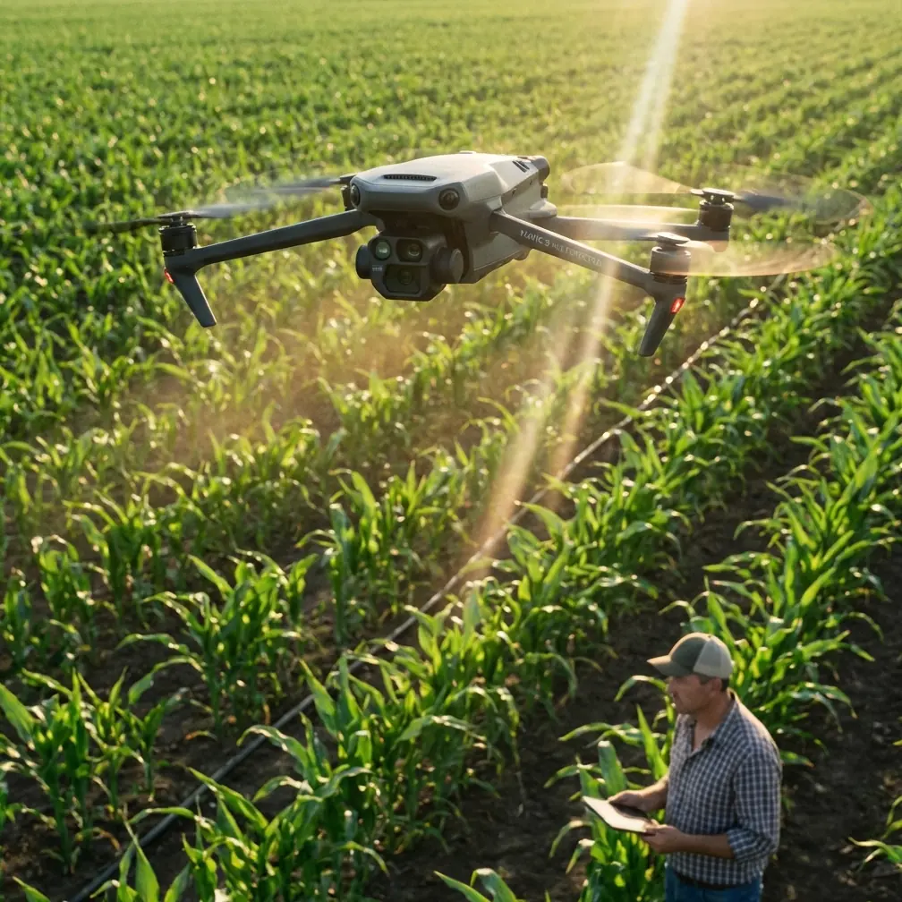
That is where the Mavic 3M earns its place. Not because it is trendy, but because it fits a very specific kind of agricultural work: fast deployment, repeatable multispectral collection, and the ability to gather decision-grade data without dragging a large field operation into every vineyard block.
Still, the aircraft is only part of the system. In coastal vineyard surveying, the difference between useful output and wasted flight time usually comes down to workflow discipline. The reference material behind this article points to a truth agricultural drone teams learn quickly: successful field operations are built as much on logistics and team coordination as on airframe capability. One source even recommends a three-person setup for agricultural drone work—a pilot, a support technician, and an observer—and that logic translates surprisingly well to Mavic 3M missions in vineyards. You may be flying a compact mapping platform rather than a spraying rig, but the operational principle is identical: defined roles reduce downtime, catch mistakes early, and keep data quality consistent across long days.
Start before the vineyard: block intelligence beats improvisation
A good Mavic 3M survey begins before the drone leaves its case.
One agricultural operations reference stresses that crews should confirm acreage, terrain, obstacle density, and local support conditions before arriving on site. For vineyard mapping, that advice is not administrative busywork. It directly affects mission success.
In coastal vineyards, “terrain” is rarely just slope. It can mean terraces, abrupt elevation changes, retaining walls, tree lines, windbreak structures, irrigation hardware, anti-bird netting, and access lanes too narrow for easy repositioning. If you do not know where these are, your swath width planning and overlap assumptions may collapse once you are in the field. A block that looks simple on a desktop basemap can turn into three separate missions because of elevation steps or restricted takeoff zones.
This is also where the Mavic 3M’s compact form is valuable. Compared with heavier agricultural platforms that require a broader support footprint, it can be moved quickly between blocks. But “quickly” only stays true if the site is pre-assessed. If vehicle access is poor, if launch points are unsafe, or if a row-end turnaround area is blocked, your sortie tempo slows down and your battery cycle gets messy.
For vineyard consultants working in coastal conditions, a useful habit is to confirm five things with the grower or manager in advance:
- exact block boundaries
- elevation changes within the block
- recent irrigation or wet ground that affects access
- physical obstructions above canopy height
- preferred staging area away from workers and vehicles
That sounds basic. It is not. It is what prevents a precision mission from becoming reactive field improvisation.
The pre-flight cleaning step many teams rush
The prompt for this article called for a pre-flight cleaning step tied to safety features, and in coastal vineyards, that is not optional.
Salt residue, fine dust, pollen, and spray remnants accumulate faster near vineyards than many operators expect. Before power-on, inspect and gently clean the vision sensors, camera windows, and airframe surfaces that affect obstacle sensing and image quality. On a multispectral platform, this step matters twice: once for flight safety and again for data integrity.
A smudged sensor can interfere with situational awareness systems. A contaminated lens surface can compromise image consistency, especially if you are comparing one block to another over time. In saline air, residue is rarely dramatic enough to alarm the operator. It is just enough to degrade confidence, and that is worse, because weak signals often go unnoticed until processing.
This is also the right moment to inspect motor mounts, propellers, and body seams for grit or moisture intrusion. The agricultural operations source emphasizes detailed pre-flight checks—motors, propellers, GPS installation, battery state, radio power, fasteners, and control parameters. While the Mavic 3M differs from a large plant-protection aircraft, the reasoning carries over perfectly. Small defects become expensive when discovered after launch.
One practical vineyard routine looks like this:
- wipe camera and sensor surfaces with approved optical materials
- check propellers for chips, deformation, and salt dust
- confirm battery contacts are clean and dry
- verify RTK setup and home point integrity
- review mission altitude against canopy variation and edge obstacles
- confirm wind trend, not just current gusts
That cleaning step takes minutes. It protects both the aircraft’s safety features and the quality of the multispectral dataset you are about to trust.
Why battery logistics still matter on a compact mapping drone
People often treat battery planning as a major issue only for spraying drones. That is a mistake.
One agricultural field reference makes a blunt recommendation for high-tempo operations: at least 8 battery sets, 3 charging stations, and a generator for one aircraft. That number belongs to large-scale spray work, but the underlying lesson is universal. Agricultural drone efficiency is shaped by energy logistics more than most teams admit.
For Mavic 3M vineyard surveys, your exact battery count will be lower, but the principle remains. Coastal jobs often involve multiple small-to-medium blocks spread across uneven access routes. If your battery rotation is sloppy, your RTK-linked mission rhythm breaks. You wait longer between flights, light conditions shift, and comparability between blocks gets weaker.
That matters because multispectral analysis is often less forgiving than operators think. If your collection window stretches too long because charging is disorganized, you can end up comparing data captured under materially different illumination and wind conditions. The aircraft performed fine, but the survey design did not.
A disciplined support setup helps here. Again, that three-person model from agricultural operations is useful:
- Pilot: mission execution, airspace awareness, capture verification
- Support technician: batteries, media handling, cleaning, launch zone organization
- Observer: obstacle watch, row-end visual awareness, worker coordination, weather tracking
For solo consultants, this does not mean you cannot operate effectively. It means you should borrow the structure even if one person fills multiple roles. Use a checklist. Stage batteries in sequence. Separate charged and depleted packs physically. Track sortie times. Record which block was flown on which battery cycle if conditions are variable.
In field reality, the professional advantage is rarely “faster flying.” It is smoother continuity.
RTK fix rate is not a spec-sheet vanity metric
In vineyards, centimeter precision has practical value only when it is stable.
Rows are repetitive. Canopy gaps can look similar. Edge features often lack dramatic visual differentiation. If you are monitoring changes over time, especially in high-value coastal vineyard blocks where irrigation, disease pressure, and soil variability interact, positional consistency matters as much as image capture.
That is why RTK fix rate deserves real attention. A weak or inconsistent fix creates downstream friction in mosaics, layer alignment, and cross-date comparison. The Mavic 3M is often chosen precisely because it can support precision-oriented mapping workflows, but that advantage depends on verifying the mission environment before launch rather than assuming the system will solve everything in post.
Coastal conditions can complicate this. Bluffs, structures, tree lines, and local interference sources can affect reception quality. If your fix status is unstable at the takeoff point, do not wave it away. Resolve it there. Waiting until after the mission usually means reflying.
This is one of those moments where operational discipline beats confidence. The same source material that stresses understanding the aircraft well enough to diagnose small faults in the field is highly relevant here. A professional Mavic 3M operator should be able to distinguish between a planning issue, a positioning issue, and a sensor issue before the mission starts. Otherwise, every anomaly gets blamed on “processing.”
Multispectral data is only useful if the flight matches the crop question
The Mavic 3M is not in the vineyard to produce colorful maps for a slide deck. It is there to answer specific agronomic questions.
That sounds obvious, but many surveys still fail because the mission was designed around aircraft convenience instead of crop relevance.
A coastal vineyard manager may need to know whether a low-vigor zone is tied to salinity, shallow soil, uneven drainage, replant stress, or canopy management differences. Multispectral imagery can support that analysis, but only if your mission geometry, overlap, timing, and coverage reflect the vineyard layout.
For example, swath width is not just a number to maximize. Wider coverage can improve speed, but row orientation, slope transitions, and block shape may reward a more conservative plan if the goal is cleaner analysis at the row or panel level. Likewise, flying “just because the weather is flyable” is not enough. Coastal haze, changing cloud cover, and wind-driven canopy motion all affect consistency.
There is an interesting contrast in the source data. One industry analysis highlights how companies such as Skycatch built value not merely by flying drones, but by collecting domain-specific data that helps decision-makers act. That distinction matters here. The Mavic 3M is strongest when used as part of an agronomic decision workflow, not as a standalone image generator.
Ask before each mission: what decision should this survey make easier next week?
If the answer is vague, the plan probably is too.
Even when you are not spraying, spray logic still helps
The reference materials include several details from plant-protection operations, including low-altitude, low-speed agricultural flight parameters—generally below 3 meters and under 10 meters per second—for effective spray application. Those exact parameters do not define a Mavic 3M mapping mission, but the operational thinking behind them is useful in vineyards.
Agricultural drone work succeeds when the flight profile matches the biological objective.
For spraying, that means droplet deposition, drift control, and canopy penetration. For mapping, it means image stability, repeatability, and spatial relevance. In both cases, wind matters; timing matters; terrain matters; and treating the field as a uniform surface leads to weaker outcomes.
This is particularly relevant in coastal zones where spray drift is a real management concern and where mapping may be scheduled near other active field operations. If nearby blocks are being treated, your survey workflow should account for contamination risk to lenses and sensors, crew safety near chemical handling, and the possibility that active operations affect access and launch timing.
Nozzle calibration may belong to spray teams, not Mavic 3M crews, but the mindset is transferable: calibrate the system to the mission, not the other way around.
The service model fits vineyards better than many growers think
One market analysis in the source material argues that on-demand drone service is often a better fit than ownership, because the user does not need to buy the aircraft or master the operation. That observation is especially relevant in vineyards.
Many coastal vineyards do not need a full-time drone department. They need reliable seasonal intelligence at the right moments: early vigor benchmarking, irrigation troubleshooting, block comparison, stress monitoring, and pre-harvest variability review. For those operations, a structured survey service can be more rational than internalizing every part of the workflow.
This is not just about convenience. It is about execution quality. Vineyard mapping rewards operators who can integrate flight planning, RTK reliability, multispectral capture discipline, and agronomic interpretation. If a grower is evaluating whether to build that capability internally or use a specialist, the real question is not “who owns the drone?” It is “who can produce consistent, trusted decisions from the data?”
If you want to compare notes on setting up a coastal vineyard workflow around the Mavic 3M, this direct field chat link is a practical place to continue the conversation.
A final field rule: solve small problems where they start
One of the strongest ideas in the agricultural operations reference is easy to overlook: teams should understand their aircraft deeply enough to identify the root cause of small faults immediately, so minor issues do not halt the entire task.
That is exactly right for Mavic 3M vineyard work.
A loose propeller, dirty lens, unstable RTK initialization, poor block boundary setup, mislabeled batteries, or an avoidable relaunch point error can cascade into bad data, delayed collection, and a lost weather window. None of these are dramatic. All of them are expensive in practice.
The best Mavic 3M operators in vineyard environments are not the ones who talk most about hardware. They are the ones who maintain a clean aircraft, verify precision before launch, organize batteries and crew roles, and shape each mission around the grower’s real decision point.
That is how a compact multispectral platform becomes operationally serious.
Ready for your own Mavic 3M? Contact our team for expert consultation.