Mavic 3M in Mountain Vineyards: What China’s Hybrid UAV
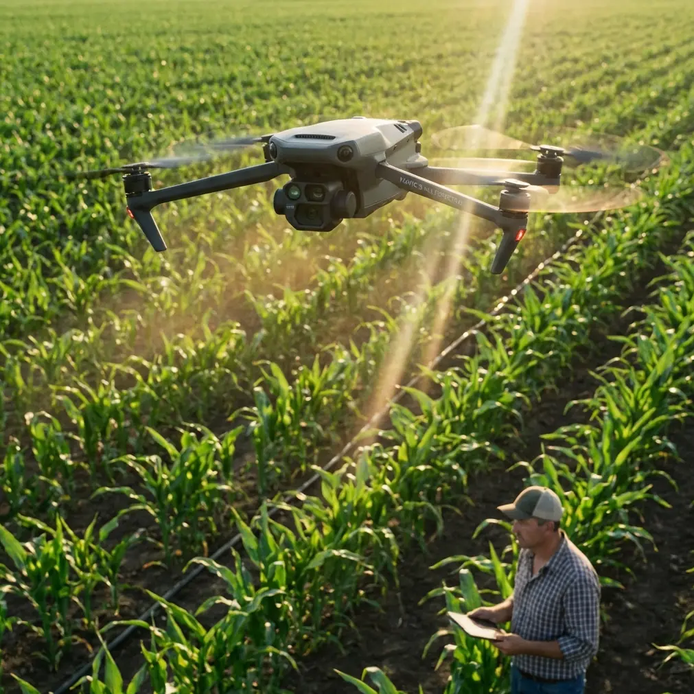
Mavic 3M in Mountain Vineyards: What China’s Hybrid UAV Push Signals for Real-World Survey Planning
META: A field-focused case study on using the Mavic 3M in mountain vineyards, with expert insight on flight altitude, multispectral mapping, RTK precision, and what China’s latest hybrid drone momentum means for agricultural UAV operations.
Mountain vineyards punish weak assumptions.
A mission that looks simple on a flat demo plot becomes complicated the moment rows start climbing a slope, light shifts across ridgelines, and wind begins moving unevenly through the canopy. If your goal is to produce actionable crop intelligence with the DJI Mavic 3M, success depends less on broad marketing claims and more on understanding where the UAV sector is heading, what endurance constraints still matter, and how to tune your flight profile to the terrain in front of you.
That is why a recent Chinese industry signal matters more than it may appear at first glance. In the latest installment of the state-backed 国家工业密码·未来篇 initiative, the featured story was not about consumer electronics or even automotive technology. It centered on a hybrid-power drone, specifically the 彩虹 YH-1000S, described as the world’s first hybrid unmanned cargo aircraft. That detail is operationally significant. It shows that in China, UAV development is no longer being treated as a narrow imaging category. The center of gravity is shifting toward endurance, logistics, and mission persistence.
For Mavic 3M operators, especially those working in mountain viticulture, that shift matters now.
I spend a lot of time advising growers, integrators, and survey teams on how to extract useful agricultural decisions from aerial data instead of just generating attractive maps. When the product focus is the Mavic 3M and the scenario is a mountain vineyard, the question is not whether the aircraft can fly the mission. It can. The real question is how to structure the mission so the data remains agronomically clean despite terrain, fragmented parcels, and variable microclimates. The larger industry move toward hybrid UAVs offers a useful backdrop because it highlights the one limitation small multirotors still cannot ignore: practical coverage per sortie.
A mountain vineyard case study
Let’s put this into a realistic setting.
A vineyard operator in a steep upland block wants to identify stress patterns before visible canopy decline spreads row to row. The property is broken into terraces and angled corridors rather than neat rectangular fields. Vehicle access is slow. Walking the block takes hours, and by the time a crew finishes visual inspection, the light has changed and the observations are already inconsistent.
This is the sort of job where the Mavic 3M is at its best.
Its value in vineyards is not simply that it flies a camera overhead. It is that it combines RGB and multispectral capture in a package small enough to deploy quickly, precise enough to support repeat missions, and stable enough to revisit the same block under similar parameters. In mountain terrain, that repeatability is everything. A single map is interesting. A stack of maps aligned over time becomes management intelligence.
The recent Chinese news around hybrid UAVs helps frame the difference between platform classes. A hybrid cargo aircraft such as the YH-1000S exists to stretch endurance and payload logic much farther than a compact mapping drone. A Mavic 3M is a surgical instrument by comparison. It is not meant to replace long-endurance logistics systems. It is meant to produce high-quality, plot-level agronomic insight with speed and precision. Understanding that distinction keeps operators from trying to force the wrong workflow onto the wrong aircraft.
Why the hybrid-drone story matters to Mavic 3M users
At first glance, a hybrid cargo drone and a vineyard survey drone seem to belong in different conversations. They do not.
The central message from the 国家工业密码·未来篇 feature is that Chinese drone development is pushing beyond pure electrification in use cases where mission duration and transport efficiency matter most. That is a clue about where the market sees demand: longer operations, larger service radii, and more resilient deployment models. The same pressure is already felt by agricultural survey teams, even if the answer for them is not hybrid propulsion.
Here is the practical takeaway. In a mountain vineyard, your bottleneck is often not image quality. It is mission segmentation. Shorter flights force more battery swaps, more launch points, and more stitching across terrain breaks. Every additional sortie introduces opportunities for mismatch in light angle, wind behavior, and canopy movement. When the broader UAV industry starts emphasizing hybrid endurance, it is effectively validating a pain point field operators already know well: time aloft changes what is operationally possible.
That does not make the Mavic 3M less relevant. It makes disciplined mission design more valuable.
The altitude insight that usually makes the biggest difference
If I had to give one field recommendation for surveying vineyards in mountain terrain with the Mavic 3M, it would be this:
Fly lower than many teams initially want, but keep the altitude consistent relative to canopy, not takeoff point.
In practical terms, an effective starting range is often around 50 to 70 meters above canopy, then adjust based on slope severity, row spacing, and the vigor variability you need to resolve. On flatter vineyards, operators sometimes push higher to cover area quickly. In mountains, that shortcut tends to dilute the exact details that matter most.
Why this range works:
- At roughly
50 to 70 meters above canopy, multispectral datasets usually retain enough ground detail to show row-level variability without creating unnecessary noise from flying too low over uneven terrain. - It helps preserve consistent
swath widthwhile still keeping pixel resolution useful for identifying patchy stress, skipped growth, water imbalance, or disease progression zones. - In steep vineyards, the key is terrain following. If you hold a constant height above the launch site instead of above the canopy, one side of the block becomes too high and loses detail, while another section may be flown too low and compromise overlap quality.
This is where RTK performance becomes more than a specification sheet item. A strong RTK Fix rate supports clean georeferencing and repeatability between missions. In a mountain vineyard, that repeatability matters for comparing one pass to the next after irrigation changes, nutrient adjustments, or weather stress. When growers talk about centimeter precision, they are not chasing abstract accuracy. They are trying to ensure that a weak patch identified today lines up with the same vines next week, not a shifted estimate three rows away.
Multispectral value in difficult terrain
Mavic 3M missions in vineyards are often discussed too casually, as if multispectral capture automatically generates useful agronomy. It does not. Good data depends on geometry, timing, and consistency.
Mountain vineyards are especially sensitive because slope orientation affects sunlight exposure throughout the day. South-facing rows may mature differently from shaded sections just across a drainage line. Wind can also drive uneven evapotranspiration. From the air, these differences often appear before they are obvious from the ground, but only if the data is captured under disciplined conditions.
This is where the Mavic 3M earns its keep. Its multispectral workflow allows teams to detect spatial variation with much more nuance than standard RGB imagery alone. In a mountain block, that can translate into:
- isolating underperforming terraces that need inspection before stress becomes visible from the road
- comparing canopy vigor across elevation bands
- identifying drainage-related weak zones after rain events
- refining scouting routes so field crews walk to the right vines first
That last point matters more than most operators admit. The purpose of a vineyard survey is not to produce a beautiful colorized orthomosaic. It is to shorten the distance between detection and intervention.
If a grower needs help structuring an efficient survey workflow around those decisions, I usually suggest starting the conversation with a field-specific mission outline here: send over your block details.
What the Guangzhou medical rescue story tells us about low-altitude operations
Another recent Chinese UAV-related development also deserves attention, even though it comes from a different operational sector. Guangzhou is advancing a 1-hour low-altitude medical rescue circle, and reporting notes that since the local aviation medical rescue base was completed in 2025, it has already contributed to casualty transfer, event medical support, and critical patient transport.
Why mention emergency medical aviation in an article about the Mavic 3M?
Because it reinforces a broader reality: low-altitude airspace in China is moving toward practical integration, not speculative demonstration. Medical rescue requires reliability, dispatch logic, and coordinated operating frameworks. That progress does not directly alter a vineyard survey mission, but it does point to a maturing ecosystem where professional UAV operations are being normalized around real outcomes.
For agricultural users, the significance is indirect but real. As more low-altitude use cases become institutionalized, expectations rise across the board for mission planning discipline, safety procedures, and operational consistency. Vineyard teams using the Mavic 3M should think like professionals inside that larger ecosystem, not hobby pilots carrying a sophisticated camera.
What mountain vineyard teams still get wrong
Even experienced operators make predictable mistakes in this environment.
The first is over-prioritizing total area per flight. In steep blocks, coverage obsession usually leads to higher altitude, weaker terrain conformity, and softer data. A shorter mission with stronger overlap and better canopy-relative altitude often produces far better decisions.
The second is treating all rows as aeronautically equivalent. They are not. Ridge-edge rows, lower pockets near drainage channels, and terraces adjacent to stone walls all behave differently in wind and light. Mission plans should reflect that.
The third is confusing agricultural mapping with spray operations. Terms like spray drift, nozzle calibration, and IPX6K belong more naturally to application drones than to the Mavic 3M, but they still matter in mixed-fleet vineyards. If your survey identifies stress and your next step is variable treatment using a separate spraying platform, the handoff has to be clean. Drift risk in mountain winds can undermine the value of precise survey data. In other words, mapping accuracy is only half the chain. Execution in the field finishes the job.
A practical mission framework for Mavic 3M in vineyards
For teams surveying mountain vineyards, this is the framework I recommend most often:
Start with one block, not the whole estate. Build a repeatable mission on a representative parcel with clear topographic variation. Fly at 50 to 70 meters above canopy as the first benchmark. Review whether row definition, overlap, and vigor differentiation are strong enough for your actual decision-making process, not just for visual appeal.
Next, watch your RTK Fix rate closely. If the correction quality is inconsistent, the map may still look acceptable at a glance while undermining time-series comparison. In vineyards, time-series reliability is where the real economic value often sits.
Then compare the map against boots-on-ground scouting within the same day. That step filters out false confidence. Multispectral outputs should direct a field team to vines that genuinely need inspection.
Finally, standardize your time of day and flight geometry for follow-up missions. Mountains exaggerate light inconsistency. If one flight is captured under stable illumination and the next is taken with dramatically different shadow structure, interpretation becomes harder than it needs to be.
The bigger picture
China’s recent coverage of the hybrid 彩虹 YH-1000S and Guangzhou’s low-altitude medical rescue buildout points to a drone industry entering a more mature phase. The message is not that every UAV should become hybrid or that every operator should think like an emergency network planner. The message is that mission-specific design is winning.
That is exactly how the Mavic 3M should be used in mountain viticulture.
It is not a one-drone answer to every agricultural challenge. It is a highly effective survey platform when the operator respects terrain, understands multispectral workflows, and plans for repeatable, canopy-relative data capture. The best results come from matching the aircraft’s strengths to the vineyard’s real management questions.
If the question is where to inspect first after a weather swing, the Mavic 3M is exceptionally useful. If the question is how to monitor terrace-by-terrace vigor over time with centimeter precision, it is in its element. If the question is how to stay airborne for logistics-scale endurance, the latest Chinese hybrid UAV story shows that another class of aircraft is being built for that job.
For mountain vineyards, that distinction is not academic. It is the difference between collecting data and actually improving the block.
Ready for your own Mavic 3M? Contact our team for expert consultation.