Mavic 3M Surveying Tips for Venues in Extreme Temperatures
Mavic 3M Surveying Tips for Venues in Extreme Temperatures: What Actually Holds Up in the Field
META: Practical Mavic 3M surveying guidance for extreme hot and cold venue conditions, with multispectral workflow tips, RTK precision considerations, accessory choices, and lessons drawn from recent UAV deployment facts.
By Dr. Sarah Chen
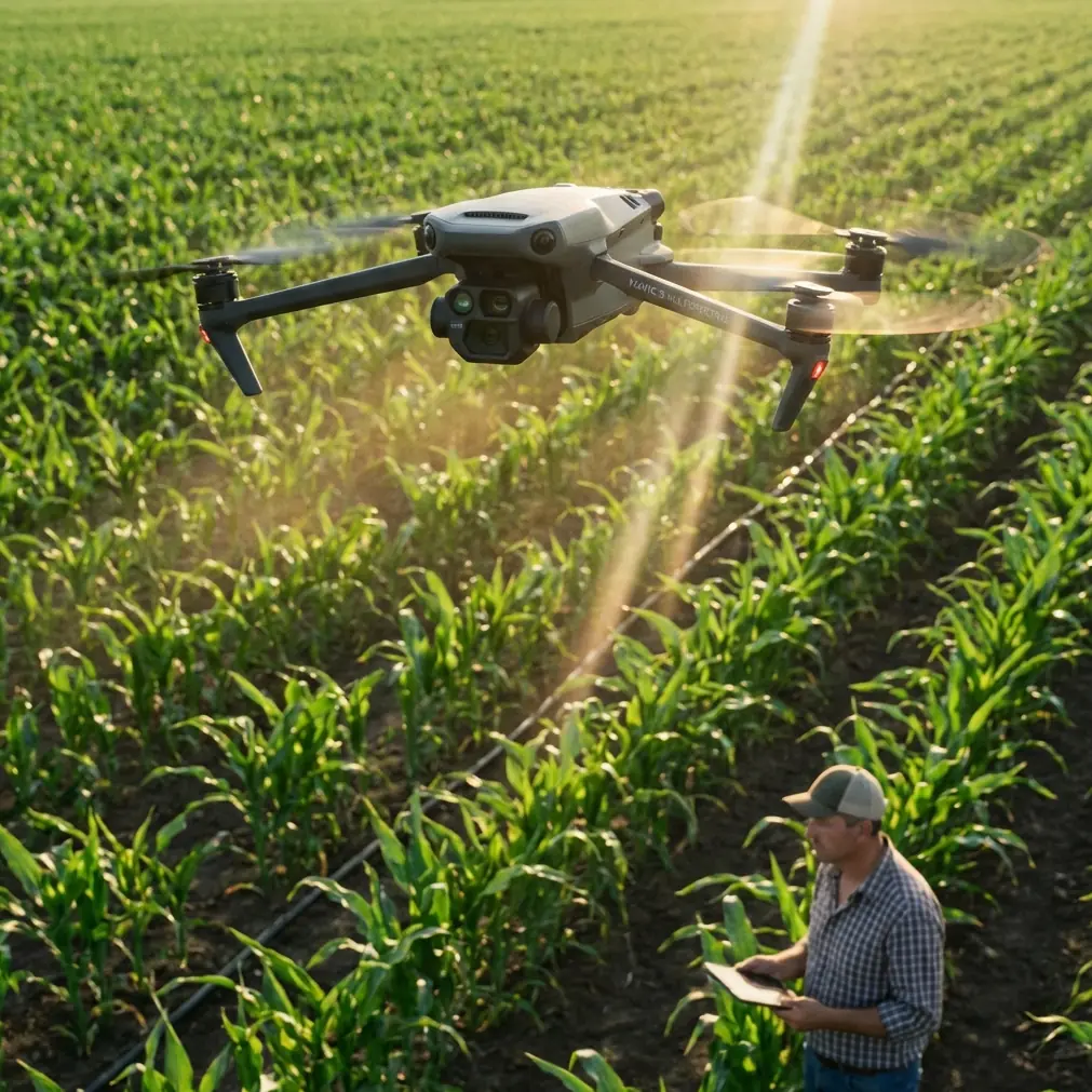
Extreme-temperature venue surveying exposes a truth that spec sheets tend to hide: the aircraft is only one part of the system. The mission succeeds or fails on workflow discipline, positioning stability, payload relevance, and how well the operator adapts when the environment starts stripping away margins.
That is why the recent reporting around Chinese UAV deployments is worth examining, even if your own work is strictly civilian. One detail stands out. A domestically developed monitoring drone system was used for aerial sensing while coordinating closely with a ground response team. Another detail matters just as much: the same manufacturer was highlighted three times by national television within two months, after appearing in support contexts tied to a crewed space program and a regional emergency rescue center. Strip away the headline framing and the operational lesson is clear. High-stakes drone work is no longer about a flying camera in isolation. It is about a reliable airborne sensor platform working as one node in a larger field operation.
That lesson transfers directly to the Mavic 3M, especially for venue surveying in heat, cold, wind, and mixed-surface conditions.
The real problem with venue surveying in extreme temperatures
When people discuss extreme-weather drone work, they often focus on battery life and stop there. That is too narrow.
For venue surveying, the real problem is data confidence under environmental stress. A sports complex, festival ground, industrial campus, race venue, or temporary event site can look straightforward from above. In practice, extreme temperatures introduce at least five failure points:
- Battery performance becomes unpredictable
- RTK fix behavior may take longer to stabilize
- Ground control and reflectance consistency become harder to maintain
- Surface contrast shifts dramatically with temperature and sunlight angle
- Operators rush flights to “beat the weather,” which usually harms data quality
The Mavic 3M is unusually well suited to this kind of work because its multispectral payload helps operators move beyond simple visual mapping. That matters when venue managers need more than a pretty orthomosaic. They may need to identify drainage stress in turf, heat-related vegetation decline around pedestrian corridors, irrigation anomalies, or recurring surface issues that affect maintenance and safety planning.
In hot conditions, these changes can appear fast. In cold conditions, they can be subtle and spatially inconsistent. Multispectral data helps reveal patterns that RGB imagery alone can miss.
Why recent UAV deployment facts matter to Mavic 3M users
The reference material describes an aerial monitoring drone being used in coordination with ground teams, and notes that the broader UAV portfolio has reached missions involving high-altitude transport in Tibet and deck operations at sea. For Mavic 3M operators, the key insight is not the platform class. It is the operational standard behind those deployments.
Two facts are especially relevant.
First, the aerial system was used as a monitoring layer, not a standalone tool.
That is exactly how the Mavic 3M should be used on serious venue projects. Its value increases when its outputs are tied to ground verification, maintenance records, irrigation maps, or engineering inspections. If your multispectral map shows stressed turf around the perimeter of a stadium parking field, the correct next step is not to trust colorized outputs blindly. It is to validate with on-site observations, moisture checks, or drainage assessment.
Second, the reported manufacturer achieved repeated exposure across different operational settings within two months.
That speaks to something venue survey teams should respect: repeatability across scenarios. A UAV workflow that only works on ideal mornings is not mature enough. The Mavic 3M earns its place when it can deliver usable outputs across hot asphalt, cold dawn air, mixed vegetation, reflective roofing, and partially shaded service zones.
Extreme-temperature surveying is not about hero flights. It is about repeatable capture.
Where the Mavic 3M has an edge at venues
The Mavic 3M is often discussed as an agriculture aircraft because of its multispectral payload. That is true, but it understates how useful the platform can be in venue environments.
A venue is usually a mix of surfaces and management zones:
- natural turf
- ornamental landscaping
- drainage channels
- paved access roads
- rooftop structures
- temporary event overlays
- utility corridors
With multispectral imaging, you can separate plant stress from purely visual discoloration and detect management patterns that would otherwise be anecdotal. This is especially useful when extreme heat is causing localized decline that starts before field staff can see it at ground level.
Centimeter precision also matters here. If you are revisiting the same venue after a heat wave or a cold snap, precise alignment between flights determines whether change detection is meaningful or noisy. In this context, RTK fix rate is not just a technical metric. It is the difference between actionable comparison and fuzzy interpretation.
A venue manager does not care whether your map looks sophisticated. They care whether Zone B really degraded relative to last month, and whether the problem is spreading.
Cold-weather surveying: what tends to go wrong first
In cold conditions, the Mavic 3M can still be an excellent survey tool, but operators need to manage mission tempo carefully.
The first failure is often not aircraft control. It is workflow impatience.
Cold-weather crews often shorten preflight procedures because they want to get airborne quickly. That leads to rushed RTK initialization, poor base station placement, and weak reflectance control. If you launch before your positioning solution is stable, the rest of the mission may be compromised from the first line.
For venue work, that means:
- repeated passes may not stack cleanly
- edges of fields or structures may drift
- multispectral comparisons across dates become harder to trust
If your operation depends on centimeter precision, do not treat RTK lock as a formality. Treat it as a gate.
Cold also changes how surfaces behave visually. Frost residue, low-angle light, and cold-soaked synthetic materials can create misleading contrasts in RGB imagery. This is where the Mavic 3M’s multispectral capability becomes more than a bonus. It gives you another way to interpret what you are seeing, especially in mixed turf-and-built environments.
Heat surveying: more data, more traps
High-temperature venue surveys bring the opposite problem. Everything looks clear, and that can fool operators into thinking conditions are simple.
They are not.
Heat shimmer, reflective roofs, sun-glare on hardscape, and stressed vegetation can produce noisy captures if your flight window is poorly chosen. The Mavic 3M can still collect highly valuable data, but the operator needs discipline in timing and overlap planning.
If the venue includes managed turf, one operational concept borrowed from agricultural practice is useful: think in terms of swath width and consistency, not just area coverage. Overheated crews often widen mission spacing to save time, but that can weaken data continuity over the exact zones where subtle stress patterns matter most.
This is also where some agricultural language becomes unexpectedly relevant. Terms like spray drift and nozzle calibration usually belong to application drones, not the Mavic 3M. But for venue managers who also oversee landscaping or turf treatment, your survey outputs may feed those downstream decisions. If a multispectral map is later used to guide irrigation adjustments or targeted application planning, then understanding treatment boundaries, wind effects, and calibration logic becomes operationally significant. The survey is not the end of the process. It is the upstream intelligence layer.
A third-party accessory that genuinely helps
One accessory category has proven especially valuable for extreme-temperature venue missions: a high-visibility landing pad with insulated battery handling case from a third-party field kit supplier.
That sounds modest, but it solves a real problem.
In hot venues, paved surfaces can radiate intense heat into batteries and electronics during turnaround. In cold venues, placing batteries and aircraft on damp ground or frost-covered grass introduces avoidable thermal shock and contamination risk. A stable landing pad reduces dust, moisture transfer, and heat soak. An insulated handling case helps batteries remain within a more workable temperature range between sorties.
This is not glamorous gear. It is the kind of support equipment that improves mission consistency quietly.
If you are assembling a field kit and want practical advice on compatible accessories and workflow setup, a direct project discussion can be easier than sorting through generic recommendations: message the field team here.
How I would structure a venue mission with the Mavic 3M
For extreme-temperature conditions, the Mavic 3M works best when the mission is built around verification and repeatability.
1. Define the operational question before the flight
Do not just survey “the venue.” Identify what decision the data must support:
- turf recovery after heat stress
- drainage assessment after freeze-thaw events
- landscaping health near spectator areas
- repeatable baseline mapping for maintenance planning
The multispectral payload becomes far more useful when tied to a narrow operational question.
2. Protect RTK integrity
Watch the RTK fix rate and do not rush launch. In a venue with metal structures, scoreboards, lighting towers, or partial roof cover, positioning can be less forgiving than it appears from the ground.
If your aim is centimeter precision across repeated surveys, weak initialization is the sort of mistake that quietly ruins the value of later analysis.
3. Standardize your capture window
For comparison flights, use similar lighting and temperature timing whenever possible. Extreme weather already introduces enough variability. Do not add more by changing your collection window every time.
4. Use multispectral outputs to direct ground checks
This is where the reference material offers the strongest lesson. The reported aerial monitoring mission worked in coordination with a ground team. Civilian venue operations should do the same. Let the Mavic 3M identify anomalies, then confirm them on foot. That approach reduces false positives and increases trust from facility managers.
5. Build a repeat survey cadence
One-off maps can be impressive. Repeated maps create operational value. If a venue has recurring thermal stress, irrigation inconsistency, or seasonal decline, a flight series reveals much more than a single capture ever could.
The larger takeaway
The source reporting points to a broader industry reality: UAV credibility is earned through performance in difficult environments and through integration with real operational workflows. One report described an aerial sensing system working alongside ground units. Another highlighted repeated public exposure across major national tasks in a two-month span. Whatever the platform category, those facts reflect the same principle serious Mavic 3M users should adopt.
The aircraft is not the whole solution. The mission system is.
For surveying venues in extreme temperatures, that means:
- disciplined RTK setup
- careful thermal management
- meaningful multispectral interpretation
- standardized repeat flights
- ground verification built into the workflow
Used that way, the Mavic 3M becomes much more than a mapping drone. It becomes a practical decision tool for venue operators who need to understand what is changing, where it is changing, and whether the pattern is real.
That is the difference between collecting imagery and delivering insight.
Ready for your own Mavic 3M? Contact our team for expert consultation.