Mavic 3M in Mountain Venue Surveying: Why “Pretty” Images
Mavic 3M in Mountain Venue Surveying: Why “Pretty” Images Matter Less Than Trustworthy Data
META: A field-based case study on using the DJI Mavic 3M for mountain venue surveying, with lessons on multispectral capture, RTK fix reliability, terrain-driven planning, and why phone-like image punch can mislead real survey decisions.
When people first look at imagery from a professional camera system, they often react the wrong way.
The complaint is familiar: the files can seem gray, flat, darker than expected, and less visually pleasing than what a phone produces automatically. A recent photography piece made that point bluntly. Even when a camera costs several times more than a phone and carries stronger sensor specifications, the image straight out of camera may still look less vivid if no post-processing is applied. Phone photos often appear clearer, brighter, and more polished right away because they are heavily optimized for visual appeal.
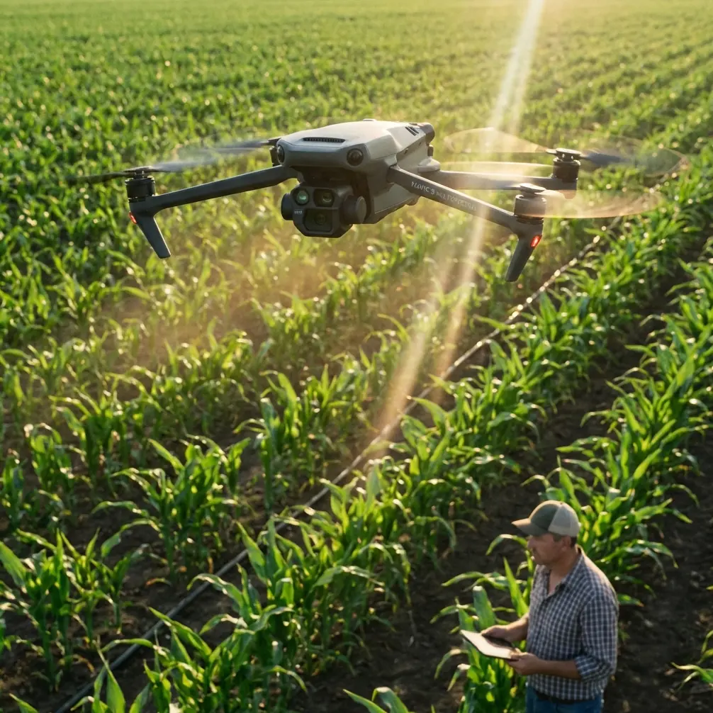
That consumer photography truth becomes surprisingly relevant when the aircraft in question is the Mavic 3M.
I have seen this misunderstanding play out in mountain venue surveys, especially when project teams are assessing slopes, access corridors, event grounds, drainage lines, and vegetation conditions around remote sites. A manager opens the first set of outputs and says some version of: “Why do these images look less impressive than the phone shots from the recce team?” It is the wrong benchmark. The Mavic 3M is not built to flatter the eye first. It is built to help you make defensible decisions.
That distinction matters even more in mountains, where lighting is harsh, shadows are deep, elevation changes are abrupt, and site conditions can change over a few hundred meters.
The mountain venue problem
Venue surveying in mountain terrain is different from flat-land site capture. You are not just documenting a footprint. You are trying to understand how terrain, vegetation, exposure, and access interact. A mountain event site may include parking and logistics areas in one zone, foot traffic routes in another, and infrastructure staging in yet another. Some sections may be sunlit and reflective. Others stay in shadow for most of the day. Wind behaves differently along ridgelines and in cut valleys. That affects both flight planning and the quality of the usable dataset.
This is where the Mavic 3M starts to separate itself from “good-looking” imaging tools.
The value is not that every frame looks saturated and finished. The value is that the platform combines standard visual capture with multispectral information and RTK-enabled positional performance in a compact aircraft that can be deployed quickly in difficult topography. If your goal is to produce a site understanding that stands up to engineering review, agronomic interpretation, vegetation management, or terrain planning, that matters far more than whether the JPEG feels punchy on a phone screen.
A case from a mountain venue assessment
Last season, our team supported a mountain venue evaluation for a multi-use upland site that was being considered for seasonal events, temporary structures, and managed visitor circulation. The property was visually striking, but that was part of the problem. Ground observers kept gravitating toward scenic impressions rather than measurable constraints.
On initial walk-throughs, staff relied heavily on smartphone photos. Those images were bright, contrasty, and immediately persuasive. The slopes looked cleaner than they were. Surface transitions appeared more uniform. Vegetation stress around drainage channels was less obvious because phone processing favored an overall attractive look rather than analytical neutrality.
We then flew the Mavic 3M over the same sectors.
The first review caused some friction. Compared with the phone images, portions of the visual dataset appeared flatter and less “finished” at first glance. But once the team shifted from aesthetic judgment to operational interpretation, the advantage became obvious. Areas that looked casually usable from the ground turned out to have uneven vegetation signatures and terrain-linked moisture patterns that affected route planning and temporary layout decisions.
That is the core lesson: in professional drone work, a more seductive image is not automatically a more useful image.
Why the “flat image” issue actually helps professionals
The photography article’s central insight is simple: dedicated cameras often do not try to make every shot look instantly vibrant without post-processing, while phones aggressively shape the image for immediate viewing. In mountain surveying, that difference can save you from bad assumptions.
A heavily processed-looking image can hide subtle cues. Shadows are lifted. Colors are boosted. Local contrast gets sharpened. The result may feel “better” but can also smooth over ambiguity. For consumer memories, that is fine. For surveying venues in complex terrain, it can distort interpretation.
With the Mavic 3M, the goal is not social-media-ready output. The goal is reliable source material. If an area is subdued in color, partly shadowed, or visually inconsistent, you generally want that reflected honestly before analysis. Especially in multispectral workflows, realism in acquisition is more valuable than baked-in beautification.
This matters when reviewing:
- vegetation vigor near paths and staging areas
- drainage influence after recent weather
- edge conditions between maintained and unmanaged ground
- stress zones near temporary infrastructure corridors
- surface consistency across proposed access routes
A phone can make all of that look cleaner than it really is. The Mavic 3M gives you a truer starting point.
Multispectral is the real difference, not just the camera look
The Mavic 3M becomes most valuable when teams stop treating it like a flying photo device and start treating it like a data collection instrument.
For mountain venues, multispectral capture can reveal vegetation variability that ordinary visual inspection misses. That does not just matter for agriculture. It matters anywhere ground condition affects human use, runoff behavior, maintenance planning, erosion risk, or route durability.
On one ridgeline section in our project, the visual imagery suggested broadly similar plant coverage across a proposed pedestrian overflow route. The multispectral layer told a different story. The vegetation response varied enough to suggest uneven moisture retention and differing root stability across the corridor. That changed where the planners wanted repeated foot traffic and where they preferred temporary reinforcement.
This is where the “flat versus vivid” debate becomes almost irrelevant. A prettier image would not have given the team the answer they needed.
RTK fix rate in mountains: the hidden make-or-break factor
Among the less glamorous but more decisive performance questions in mountain work is RTK fix stability. People talk about camera quality first. Experienced operators talk about positional confidence.
In broken terrain, line of sight, satellite geometry, cliff interference, and staging location can all affect your RTK fix rate. If your fix reliability degrades, your downstream map quality and model alignment can suffer. In a venue survey where space allocations, route boundaries, drainage buffers, and temporary asset placement all depend on accurate georeferencing, this is not a minor technical detail. It is foundational.
For our mountain site, maintaining centimeter precision was not just a specification to admire. It was the reason the client could compare successive flights over the same zones and trust the spatial relationship between them. That helped separate actual site change from visual noise caused by viewing angle, light, or rough manual alignment.
The Mavic 3M’s value here is practical. It allows a small field team to pursue high-accuracy capture without dragging a much heavier mapping setup into steep terrain. But this only works if the operator respects mountain conditions. Launch point selection, timing, mission segmentation, and antenna discipline all influence whether “centimeter precision” is real in practice or just brochure language.
Terrain planning beats one-big-mission thinking
Mountain operators who try to survey a venue in one elegant block often regret it.
Terrain changes alter overlap behavior, effective swath width, shadow characteristics, and the consistency of altitude above ground. The Mavic 3M performs better when the venue is broken into operationally logical segments: ridge, bowl, access road, staging shelf, drainage flank, tree edge. That improves both image consistency and interpretation.
On our project, segmenting the site also helped us manage wind. Ridgeline sections were flown in shorter windows with tighter acceptance criteria. Sheltered sectors were captured separately. The final stitched result was more coherent because the data came from missions planned around terrain behavior rather than convenience.
The practical significance is easy to miss: better segmentation improves not just map quality but decision quality. If one sector has weaker light or lower fix confidence, you isolate the uncertainty instead of contaminating the whole venue model.
A third-party accessory that genuinely improved results
One useful upgrade on this project was a third-party high-visibility landing pad and elevated field case platform used at improvised mountain takeoff points. It sounds mundane. It was not.
In rocky terrain with loose dust and uneven vegetation, cleaner takeoff and recovery reduced contamination risk around the aircraft and sped up battery changeovers. More importantly, it gave the team a repeatable launch environment on sloped ground. That consistency helped workflow discipline, especially when multiple short missions were needed to protect RTK quality and manage changing mountain wind.
I mention this because operators often chase the glamorous accessory and ignore the one that improves actual field execution. Mountain work rewards procedural stability more than gadget collecting.
Why venue teams should be skeptical of “looks great” imagery
There is a broader professional lesson here.
The photography article asked why expensive camera images can look less attractive than phone photos when no editing is applied. The answer, in operational terms, is that professional imaging systems are often preserving information instead of polishing it. In Mavic 3M deployments, that is exactly what you want.
If a venue owner or project coordinator judges success by instant visual pop, they may undervalue the aircraft’s strongest contribution. The useful question is not whether the images appear vivid. The useful question is whether the dataset helps you identify the site’s true limitations and opportunities.
In our mountain case, the Mavic 3M helped the team do all of the following more reliably than a phone-led recce process:
- distinguish visually similar but operationally different ground zones
- track terrain-linked vegetation variation near circulation routes
- align repeated survey outputs with high positional confidence
- plan temporary use areas with fewer assumptions based on appearance alone
That is what a professional platform should do.
Where related workflows come in
Some readers looking at Mavic 3M projects in rural or upland environments also ask about adjacent operational topics like spray drift, nozzle calibration, or weather-linked application windows. Those are relevant when a venue borders managed vegetation areas or agricultural land, especially if surrounding land use affects access timing and buffer management. The Mavic 3M does not replace those field decisions, but it can inform them by showing where vegetation condition and terrain patterns deserve closer ground verification.
In other words, the drone does not eliminate field judgment. It sharpens it.
The real benchmark for Mavic 3M success
If you are surveying mountain venues, do not let phone-era expectations distort how you assess professional drone outputs.
A dataset that arrives looking a bit restrained can still be the better dataset. In fact, that restraint may be the reason it remains analytically useful. The recent discussion from the camera world gets at the same issue from another angle: images designed to please instantly are not always images designed to tell the truth.
For Mavic 3M operators, that truth has practical consequences. Multispectral data can expose variation hidden by attractive consumer imaging. RTK fix reliability can determine whether your map supports real layout decisions. Segment-based mission planning in mountains can preserve both data integrity and safety margins. Even a simple third-party field accessory can materially improve mission consistency.
That is the kind of expertise mountain venue work demands. Not prettier pictures. Better evidence.
If you are building your own workflow and want to compare field setups for upland mapping, multispectral interpretation, or RTK planning, you can share your scenario here: https://wa.me/85255379740
Ready for your own Mavic 3M? Contact our team for expert consultation.