Mavic 3M for Remote Solar Farm Surveys: A Practical
Mavic 3M for Remote Solar Farm Surveys: A Practical Workflow When Your Office PC Is the Bottleneck
META: Learn how to use Mavic 3M efficiently for remote solar farm surveys when high-resolution RAW files slow down older computers, with a field-tested workflow for multispectral review, Camera Raw handling, and faster decision-making.
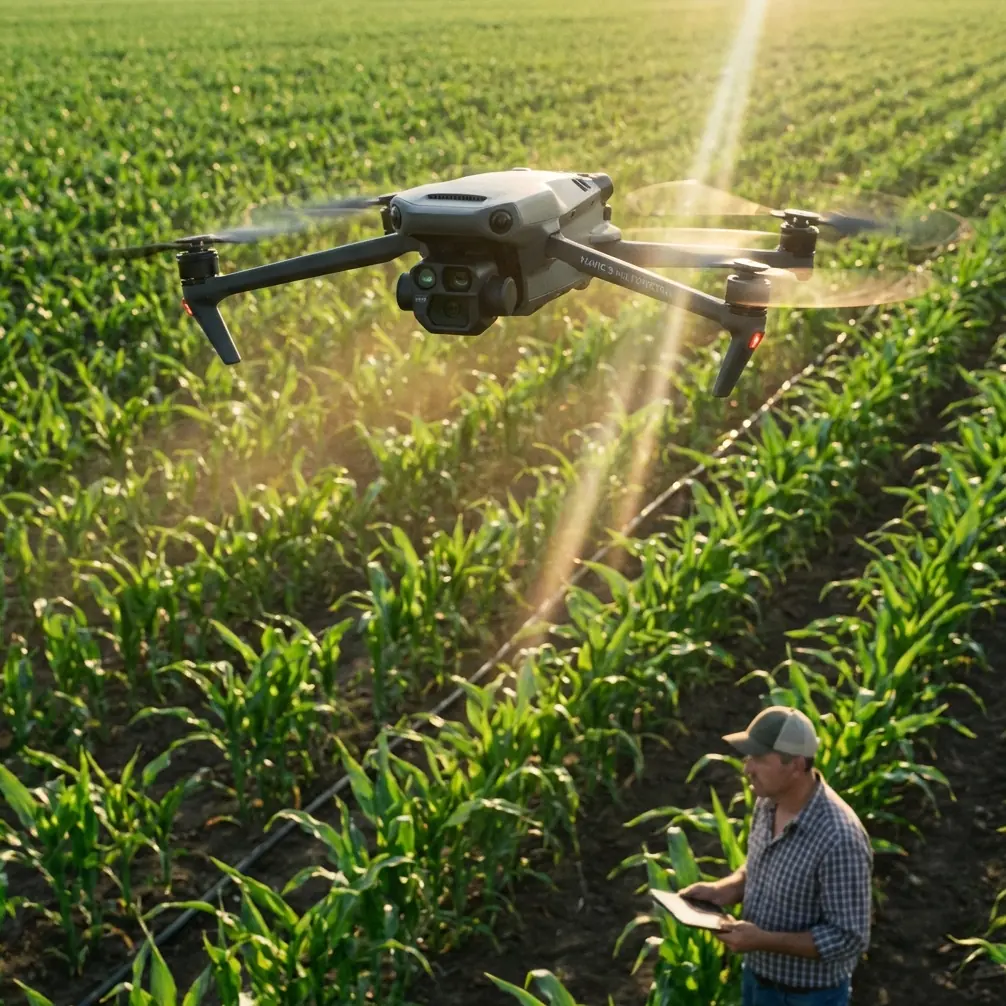
When people discuss the Mavic 3M, they usually focus on the aircraft: multispectral capture, RTK-backed positioning, repeatable coverage, and the kind of consistent data collection that makes agronomy and infrastructure monitoring far less guesswork-driven. That is all valid. But on remote solar farm jobs, the drone is only half the story.
The other half sits back in the site cabin, the regional office, or the back seat of a truck: a computer that is not nearly as modern as the aircraft feeding it.
I learned this the hard way during a remote inspection workflow built around wide-array solar sites. The aircraft did its job cleanly. The data was sharp. Too sharp, in fact, for the aging laptop we had on hand. The issue was not collecting imagery. The issue was getting from capture to interpretation without wasting the best weather window of the day while a low-spec machine froze during preview generation.
That is why a surprisingly useful lesson for Mavic 3M operators comes from a simple image-processing problem: handling high-pixel RAW files on older hardware. One reference example opened in Camera Raw measured 8215 × 5664 pixels and 62.05MB for a single RAW file. On a newer workstation, that is manageable. On an older field computer, it can become the slowest part of the mission.
For solar farm teams working in remote locations, that detail matters more than it may seem.
Why this matters specifically for Mavic 3M work
The Mavic 3M is often chosen because it reduces uncertainty in field data capture. Its multispectral workflow helps teams identify variability that standard RGB imagery can miss. In agriculture, that means crop vigor. In solar environments, the thinking is adjacent rather than identical: consistency, anomalies, edge effects, drainage changes, vegetation encroachment, and repeatable site-condition documentation around arrays and access corridors.
On paper, the aircraft makes life easier. In practice, the speed of the full workflow depends on what happens after landing.
Remote solar farm surveys often involve three constraints at once:
- Limited onsite computing power
- Large image sets collected over broad ground areas
- Pressure to review results quickly before leaving the site
If your post-flight machine struggles with high-pixel files, every decision slows down. Was that vegetation growth along the fence line real or just a display lag issue? Did the multispectral difference between two blocks point to ground moisture retention, dust migration, or simply an unreviewed exposure inconsistency? Was the RTK fix rate stable enough across the mission to support a precise comparison with previous flights?
None of those questions is easier to answer when the computer stutters each time you zoom.
The old-computer problem is not trivial
A lot of field teams underestimate the processing side because modern drones feel efficient from takeoff to landing. Yet one oversized RAW image can expose the weakest link in the system.
The source example is a good benchmark: a RAW file at 8215 × 5664 and 62.05MB opened inside Camera Raw. That is not an abstract studio-image scenario. It is exactly the kind of high-detail file that can bog down an older computer, especially when:
- multiple files are opened in sequence
- preview caching is weak
- RAM is limited
- storage is slow
- the user starts applying adjustments before the preview fully resolves
For Mavic 3M operators, this has operational significance in two ways.
First, high-detail capture is only useful if you can inspect it fast enough to make field decisions. If a solar-farm crew needs to confirm coverage before relocating vehicles or demobilizing, review speed directly affects operational efficiency.
Second, sluggish post-processing can encourage shortcuts. Teams start skipping closer inspection, relying on compressed previews, or delaying review until they return to headquarters. That may work for low-risk jobs. It is a poor habit when site access is difficult and revisits are expensive.
A better field workflow for remote solar farms
When I train teams using Mavic 3M around infrastructure corridors and utility-scale sites, I recommend treating the drone mission and the review environment as one system. The aircraft may deliver centimeter precision when paired with proper RTK conditions, but that precision loses practical value if the field team cannot comfortably inspect outputs on available hardware.
Here is the workflow that has proven most resilient.
1. Define what must be checked onsite and what can wait
Not every file needs full-resolution scrutiny in the field.
For remote solar farm work, the onsite priority list is usually:
- mission completeness
- coverage consistency
- georeferencing confidence
- obvious anomalies in target zones
- enough sample review to rule out focus or exposure issues
That is different from full analytical processing. The field goal is confidence, not final reporting.
This distinction changes how you use Camera Raw or any image-review tool on an older computer. You are not trying to finish the entire deliverable from the site trailer. You are trying to confirm that the mission is valid and worth leaving with.
2. Separate validation from deep editing
If your laptop struggles with 62.05MB-class RAW files, avoid editing every image individually during initial review. Open representative samples first.
For example, review images from:
- the beginning of the mission
- the middle of the mission
- the end of the mission
- any area where terrain, glare, or panel reflectance changed noticeably
This gives you a fast diagnostic spread. If those sample frames look clean, your full set is more likely to be usable.
That sounds basic, but it prevents the common mistake of trying to push an underpowered machine through unnecessary full-dataset interaction while still onsite.
3. Use Camera Raw strategically, not continuously
The source material specifically addresses the challenge of handling high-pixel RAW files in Camera Raw on older, lower-configuration computers. That is highly relevant because Camera Raw is often used as a quick stopgap review environment by teams who do not want to boot heavier processing pipelines in the field.
The practical lesson is this: use Camera Raw as a selective inspection tool.
If one image at 8215 × 5664 already taxes the machine, opening many files, jumping rapidly between them, and applying layered adjustments is an invitation to lag. Instead:
- open one image at a time when possible
- let previews resolve before zooming aggressively
- avoid batch-heavy visual checks on old hardware
- note suspect frames for later workstation review
This preserves the value of RAW without allowing the review software to dominate mission time.
4. Build your flight plan around post-flight reality
This is where Mavic 3M discipline pays off. A structured mission with stable altitude, consistent overlap, and reliable RTK behavior reduces the number of images you need to inspect manually.
When RTK fix rate holds well and your route geometry is repeatable, you can trust the dataset more quickly. That does not eliminate QA. It narrows it.
Operationally, this is one of the strongest arguments for taking mission planning seriously. Better in-flight consistency means less dependence on brute-force image checking later. For remote solar farm surveys, that can be the difference between wrapping the day on schedule and spending an extra hour waiting for thumbnails to build on an old laptop.
Where multispectral data changes the conversation
Solar farm readers may wonder whether multispectral work is overkill outside agriculture. Usually, the real value is not in pretending a solar site is a crop. It is in using multispectral capture to understand surface condition patterns around and between asset rows with more consistency than plain visual inspection alone.
On remote sites, that may support:
- tracking vegetation encroachment zones
- spotting drainage or moisture-related ground variation
- documenting changes near access routes
- comparing recurring stress patterns in surrounding land cover
This is where processing discipline matters even more. Multispectral imagery is useful because it supports comparison and interpretation. If the field review process is chaotic or incomplete because the laptop cannot keep up, the consistency advantage narrows.
The Mavic 3M gives you better data structure. Your job is to keep that structure intact from acquisition to interpretation.
The past challenge that changed my own process
Several years ago, on a site far enough from the main office that “we’ll just check it later” was a costly phrase, we finished a long survey window under decent light and moderate wind. The aircraft work went smoothly. The trouble started after landing.
The field computer was older than anyone wanted to admit. Opening high-resolution image files became a stop-start exercise. Zooming into critical sections lagged. Simple checks took too long. We left with partial confidence rather than full confidence, then discovered back at the office that one section needed a tighter review than we had given it.
That was the moment I stopped viewing post-flight hardware as an afterthought.
Since then, every Mavic 3M deployment plan I build for remote assets includes a file-handling strategy. Not glamorous. Extremely useful.
A practical checklist for low-spec review stations
If your survey team is using Mavic 3M in the field with modest computing resources, this is the checklist I recommend.
Before the mission
- confirm what software will be used onsite
- test one real high-resolution file on the exact field laptop
- identify whether Camera Raw can open and navigate the file without unacceptable delay
- define a sample-based QA routine rather than a full-image review routine
- verify storage space and transfer speed
During the mission
- maintain disciplined flight parameters
- watch RTK behavior and log quality
- note any lighting shifts, glare conditions, or unusual surface reflections over panel arrays
- flag segments that may require closer image inspection after landing
After landing
- inspect selected sample images first
- check focus, exposure consistency, and target area coverage
- open RAW files selectively, especially if the machine struggles with large dimensions such as 8215 × 5664
- document anything requiring office-level processing later
Back at the office
- run the full analytical workflow on stronger hardware
- compare against previous site baselines
- use the field notes to focus detailed review where it matters most
This sounds modest, but it protects the real value of the mission: confidence in your dataset.
Why this approach fits remote solar work better than brute-force processing
Remote solar farms are not friendly to inefficient habits. Distances are longer. Light windows matter. Access coordination matters. Return trips are disruptive. A workflow that depends on powerful office hardware at every stage may look elegant in theory but break down in the field.
The stronger approach is layered:
- capture cleanly with Mavic 3M
- validate intelligently onsite
- process deeply later on proper hardware
That sequence respects both the aircraft’s strengths and the reality of field operations.
If you are setting up your own workflow and want to compare field-check practices for remote solar surveys, you can message our UAV team directly here.
Final takeaway
The headline feature set of the Mavic 3M naturally gets attention: multispectral capability, repeatable mapping, and the ability to support precise site documentation over large areas. For remote solar farm surveys, though, one of the most overlooked performance factors is whether your field computer can keep pace with the imagery you collect.
A single RAW file example at 8215 × 5664 pixels and 62.05MB is enough to remind us that image detail has a cost. On older computers, that cost appears as lag, friction, and slower decisions. If you design your mission workflow with that reality in mind, the Mavic 3M becomes much easier to use well.
Not because the drone changed.
Because the whole system did.
Ready for your own Mavic 3M? Contact our team for expert consultation.