Mavic 3M on High-Altitude Solar Farms: A Field Case Study
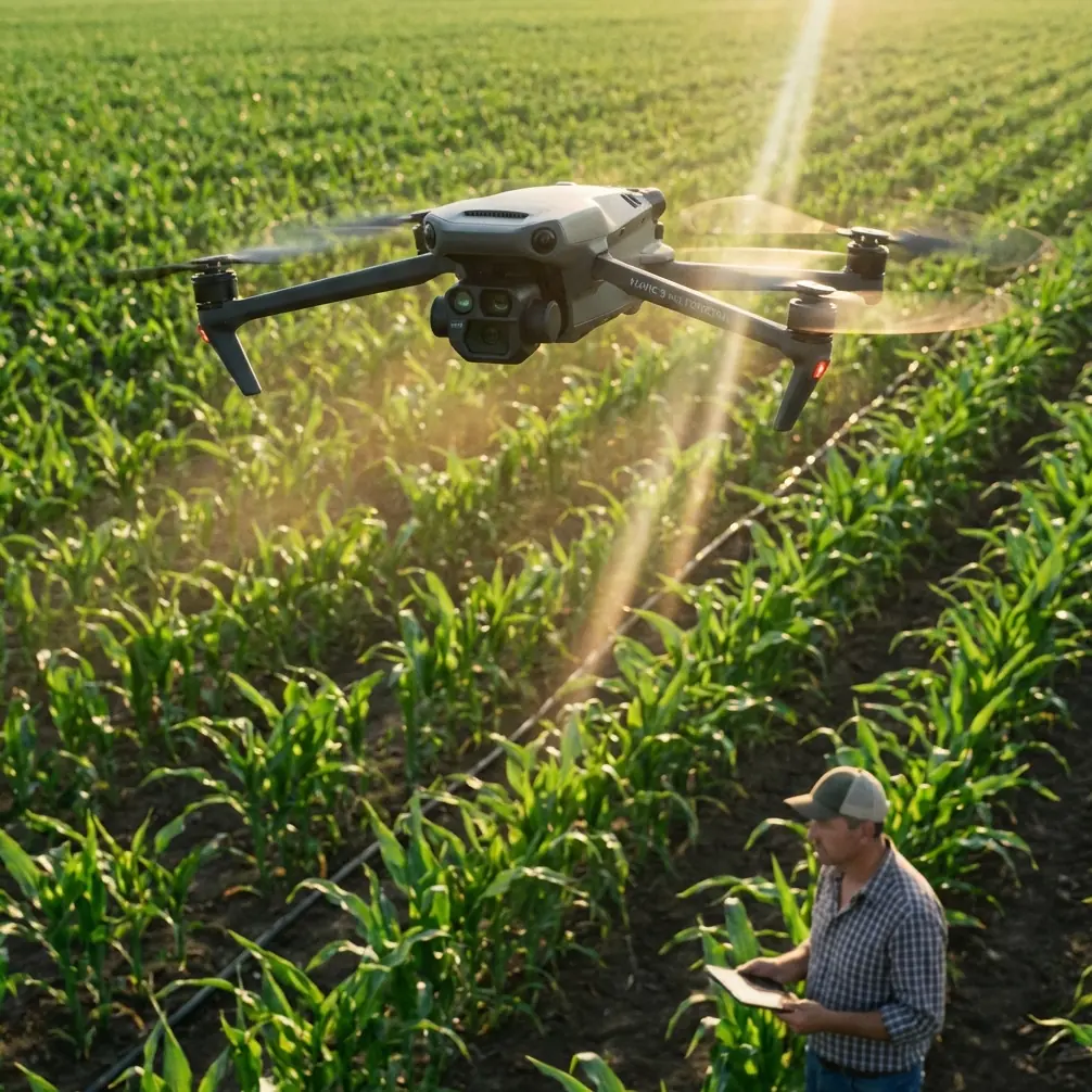
Mavic 3M on High-Altitude Solar Farms: A Field Case Study in Seeing What Others Miss
META: A consultant’s case study on using the DJI Mavic 3M for high-altitude solar farm surveying, with practical lessons on multispectral workflow, RTK precision, and image discipline drawn from real photography principles.
I’ve seen plenty of solar farm surveys go sideways for reasons that had nothing to do with aircraft specs.
The drone was fine. The weather was manageable. The mission plan looked clean on paper. Yet the output still came back weaker than it should have been—messy edge framing, poor visual context, inconsistent capture discipline, and image sets that made post-processing harder than necessary. On mountain solar sites, especially at altitude, small mistakes get amplified. Light shifts fast. Panels repeat into the distance. Terrain creates deceptive sightlines. A survey team can collect a lot of data without actually seeing the site clearly.
That is why the Mavic 3M stands out in this niche. Not just because it is a multispectral platform, and not just because RTK-backed workflows support centimeter-level positioning. The real advantage shows up when the aircraft is paired with a more disciplined way of observing. That lesson became obvious to me during a difficult high-altitude solar inspection project, where the technical side and the visual side had to work together.
The problem with mountain solar sites
High-altitude solar farms are visually repetitive, but operationally complicated.
From the air, rows of modules can look uniform enough that teams get lulled into mechanical capture habits. Fly the grid. Gather the imagery. Export the map. Move on. The trouble is that elevated terrain introduces changing angles, sharper shadows, glare pockets, and subtle discontinuities in row alignment. Drainage channels, access roads, inverter pads, retaining structures, and panel wash patterns all affect how the data reads later.
On one project, our challenge was not simply to “map the farm.” We needed to document panel blocks, identify irregular vegetation pressure around array edges, verify drainage behavior after weather movement, and create image sets the operations team could interpret without fighting the visuals.
That was where the Mavic 3M made the job easier, but only after we stopped treating it as a flying sensor package and started treating it as a tool for disciplined seeing.
What a photography lesson has to do with a solar survey
A recent photography tutorial published on 2026-04-09 made a point that applies surprisingly well to drone operations: strong images come from noticing details that most people ignore. The example was simple—a cup reflecting part of a scene. The message was not about the cup itself. It was about training your eye to stop chasing only big obvious scenery and start seeing the smaller clues that tell the real story.
That is exactly how better Mavic 3M surveys happen on solar farms.
At altitude, operators often focus only on the “big view”: total array layout, complete orthomosaic coverage, broad vegetation patterns. Those matter, of course. But some of the most useful operational insights come from less dramatic details:
- a change in reflectance along a row end
- runoff marks near a maintenance path
- slight inconsistency in plant vigor at fence lines
- recurring glare behavior on one sloped section
- transitional areas where terrain, access, and module orientation interact
The Mavic 3M is well suited to this kind of work because multispectral data rewards careful observation. If your field mindset is lazy, the aircraft’s capabilities get underused. If your field mindset is sharp, the platform becomes much more valuable.
The case: when linear structure became the key
The same photography tutorial also emphasized the value of strong lines—bridges, roads, rivers, wooden walkways—because lines create depth and perspective. That sounds like advice for street or landscape photographers. On a solar farm, it translates directly into mission planning and interpretation.
Solar assets are full of lines.
Panel rows. Service roads. Fence boundaries. Drainage channels. Cable paths. Retaining cuts. These are not just compositional elements. They are operational clues. When surveyed correctly, they reveal the logic of the site.
On one steep, high-altitude project, the farm had long row geometry broken by elevation changes and segmented access lanes. Earlier image collections from another team technically covered the site, but they did not communicate it well. The framing often cut awkwardly across row direction, and the visual context was cluttered by unnecessary foreground intrusions from terrain edges and nearby structures. In processing, the dataset was still usable, but interpretation took longer than it should have.
With the Mavic 3M, we reworked the capture logic around the site’s dominant lines.
Instead of thinking only in terms of area coverage, we prioritized the visual flow of the farm:
- align flight logic with row direction where practical
- preserve continuity across array blocks
- give transition zones their own capture attention
- avoid unnecessary visual clutter at the edges of key images
That may sound subtle. It was not. Once the image set respected the structure of the site, the resulting outputs became easier for both GIS staff and site managers to read.
The significance is operational: when roads, rows, and drainage lines are visually coherent in the dataset, anomalies are easier to locate, verify, and communicate. That saves time downstream, where the real cost usually sits.
Why simplification matters more than many teams realize
Another useful point from that 2026 photography piece was the warning against distracting foreground elements. It even suggested waiting for a person to enter the frame if that would improve the shot, rather than accepting a cluttered composition.
For drone survey work, the lesson is not about chasing artistic moments. It is about eliminating visual noise and adding meaningful scale when needed.
On high-altitude solar farms, clutter creeps in fast:
- ridge edges at the wrong angle
- partial structures intruding into oblique context shots
- maintenance vehicles parked where they distort visual reading
- shadows from nearby terrain obscuring transitions
The Mavic 3M gives you a precise and repeatable platform, but precision alone does not clean up visual confusion. The operator still needs judgment. Sometimes that means adjusting takeoff timing. Sometimes it means waiting a few minutes for site movement to clear. Sometimes it means capturing one additional contextual pass so the project manager can understand elevation relationships without guessing.
That discipline paid off for us. We stopped accepting “good enough because the sensor got it.” Instead, we built a cleaner visual package around the multispectral mission. The result was not only stronger mapping deliverables, but faster handoff to non-pilot stakeholders.
Where the Mavic 3M actually changed the workflow
The Mavic 3M did not solve the mountain environment by magic. It solved it by reducing friction in a workflow that already demanded care.
For high-altitude solar survey work, three traits mattered most.
1. Multispectral capture with practical field efficiency
Solar sites are not farmland, but multispectral logic still has real value around them. Vegetation encroachment, drainage behavior, disturbed soil, and perimeter growth patterns can all affect maintenance planning and site stability. On mountain installations, where runoff and slope management are constant concerns, that kind of layered visibility matters.
With the Mavic 3M, the team could gather the broad map while also capturing data useful for identifying vegetation and surface-condition trends around infrastructure corridors. That was especially helpful around fence lines, access margins, and lower-elevation collection points where water and growth behavior tended to diverge from the rest of the site.
2. RTK discipline that supports repeatability
In these environments, repeatability is not a luxury. It is the basis for useful comparison.
If you are monitoring the same block over time, the value of the dataset depends heavily on positional consistency. This is where RTK fix rate and stable workflow discipline matter. A cleaner fix profile reduces uncertainty in how future captures compare against the baseline. For a solar operator trying to track changes in drainage, vegetation spread, or maintenance effects, centimeter precision is not just a technical boast. It is what allows a recurring survey program to produce confidence rather than debate.
On our project, that repeatability helped us build a more defensible baseline for follow-up inspections. We were not just collecting nice images. We were creating referenceable site intelligence.
3. A compact platform that suits difficult terrain
High-altitude solar farms are rarely convenient. Access points are uneven. Walking the site can be slow. Wind exposure changes by section. A smaller aircraft footprint simplifies deployment, especially when survey windows are narrow.
The Mavic 3M’s advantage in that context is practical: less setup burden, less wasted motion, and faster adaptation when light or weather shifts. On mountain jobs, those gains stack up quickly.
A lesson from “the person entering the frame”
That photography tutorial’s suggestion to wait for a person before taking the shot may seem odd in a technical survey discussion, but it points to something many drone teams overlook: scale is part of comprehension.
In one portion of the project, operations staff struggled to understand the steepness of a particular service corridor from map outputs alone. The geometry was there. The numbers were there. But the terrain relationship did not really land for them.
So we added a controlled set of contextual visuals captured with scale awareness in mind. Not random hero shots. Useful reference imagery. Once that happened, the discussion changed. The maintenance team could immediately grasp why certain access and runoff issues were recurring.
That is a broader lesson for Mavic 3M operators working solar assets: not every image should exist only for processing software. Some should exist to help humans understand the site faster.
What I’d tell any team surveying a high-altitude solar farm with the Mavic 3M
First, do not confuse data volume with data quality. Mountain solar sites can produce a lot of imagery that still leaves interpretation gaps.
Second, train the crew to notice details, not just coverage. The photography principle of looking beyond the obvious matters here. The “cup reflection” mindset—seeing the small clue hidden inside the bigger scene—is often what separates average outputs from useful ones.
Third, use the site’s lines intelligently. Roads, rows, drainage paths, and terracing are not background features. They are the organizing structure of the entire survey. If the imagery fights those lines, the site becomes harder to read.
Fourth, simplify. If a foreground element, angle, shadow, or parked asset adds confusion without adding meaning, remove it from the visual story when possible.
Fifth, remember that your audience is not only the drone team. Asset managers, vegetation contractors, civil engineers, and operations supervisors all need to work from the result. The best Mavic 3M survey is not merely accurate. It is legible.
My takeaway after that project
Before that assignment, I already respected the Mavic 3M as a capable platform. After it, I respected it more for a different reason. It rewards operators who think clearly.
On high-altitude solar farms, the challenge is rarely just flying. The challenge is translating a complex, repetitive, sloped industrial landscape into something precise enough for analysis and clear enough for decisions. The Mavic 3M can do that well, especially when RTK-backed repeatability and multispectral visibility are paired with better visual discipline.
That combination changed the job for us. We spent less time explaining confusing imagery. We produced stronger site context. We built a baseline that the client could actually use over time.
If your team is planning similar work and wants to compare workflows for mountain solar sites, you can start the conversation here: message Marcus directly.
The aircraft matters. The mission design matters. But the operator’s eye may matter most of all.
Ready for your own Mavic 3M? Contact our team for expert consultation.