Mavic 3M for Windy Power-Line Corridors: Flight Planning
Mavic 3M for Windy Power-Line Corridors: Flight Planning That Produces Usable Data
META: A field-focused Mavic 3M workflow for surveying power lines in wind, with practical guidance on altitude, stability, coverage, RTK expectations, and why lightweight multispectral operations still depend on old lessons from crop survey and drone service models.
Power-line surveying in wind is where neat brochure assumptions tend to break apart.
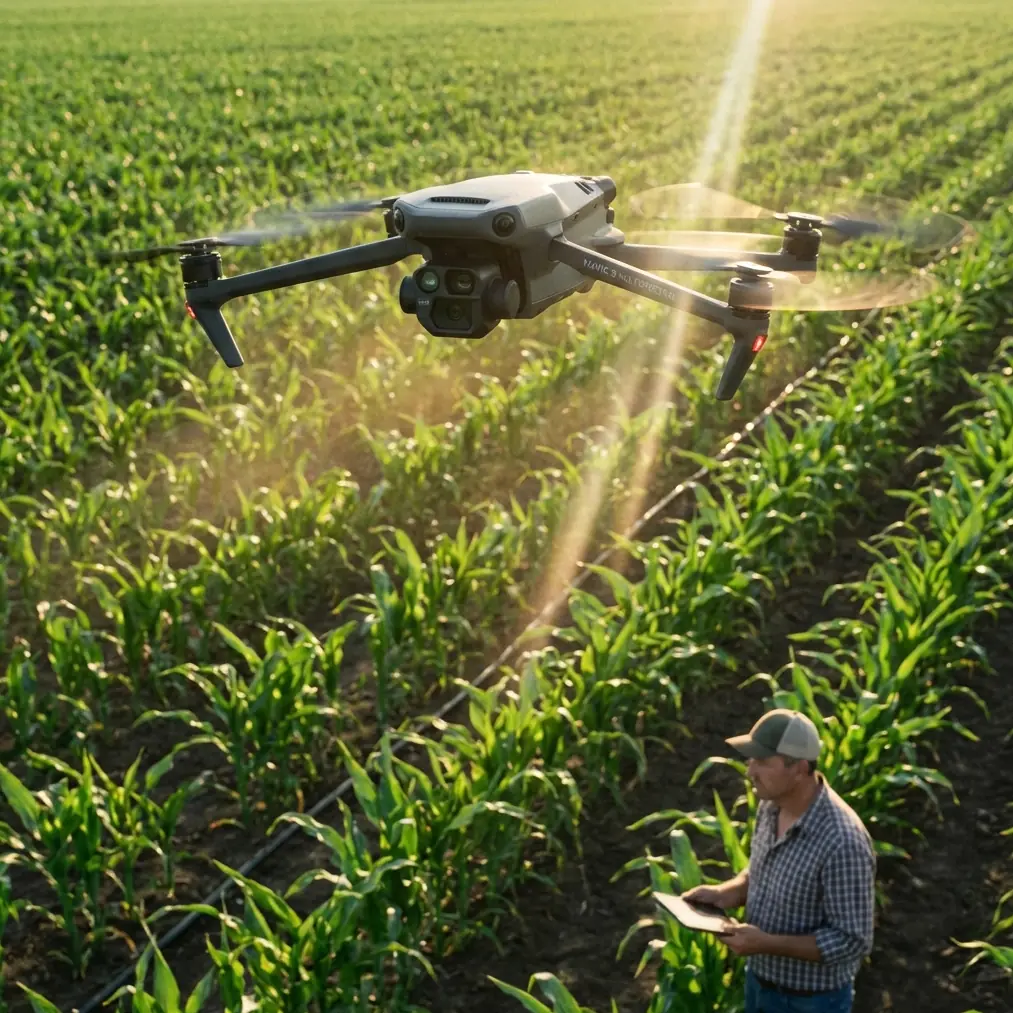
The aircraft may still fly. The mission may still complete. But the real question is whether the data is clean enough to support vegetation assessment, corridor change detection, and maintenance decisions without sending a team back out. That is exactly where the Mavic 3M becomes interesting. Not because it is merely compact, and not because it carries a multispectral payload, but because its portability changes how crews can work along long, awkward rights-of-way where access is often the real bottleneck.
I approach this as a field-operations problem, not a spec-sheet exercise.
A useful clue comes from a crop-survey hardware selection document built around small rotary-wing UAVs. Although it was written for agricultural survey rather than utility work, its logic translates surprisingly well to power corridors: lightweight multirotors are favored when the collection area is relatively small, when takeoff and landing space is limited, and when low-altitude flight needs to remain flexible and stable. That document also highlighted a practical benchmark many crews forget to quantify: a full operating kit with aircraft, backpack, batteries, and controller can stay around 5 kilograms. That matters more than it sounds when a survey team is moving repeatedly between roadside pull-offs, embankments, service tracks, and tower access points.
For Mavic 3M users, that same operational principle is central. In windy power-line environments, mobility is not a convenience. It is risk control. The faster you can relocate to a better launch point, the less pressure there is to stretch a mission beyond the safe or useful edge of the weather window.
Why the Mavic 3M fits this corridor-survey niche
The Mavic 3M is often discussed through the lens of agriculture, and that is fair. The broader UAV industry has long recognized agriculture as one of the largest commercial demand centers. One industry analysis estimated that if just 20% of China’s cultivated land adopted drone services, demand could exceed 200,000 UAVs. That same analysis also emphasized a business model shift that still matters today: many users do not need to own or deeply master an aircraft if they can buy outcomes as a service.
That point is relevant to utility and infrastructure operators too.
Power companies, vegetation contractors, and engineering firms increasingly care less about “having a drone” and more about whether the drone operation produces decision-ready data. The Mavic 3M’s strength is that it sits at the intersection of portability and analytics. In other words, it is not just a flying camera. It is a field sensor platform that can gather corridor information fast enough to fit real maintenance workflows.
There is also a second crossover from agriculture into utility surveying: low-altitude data quality. Agricultural drone practice has long exploited controlled, low-speed, low-height flight because the value comes from proximity and repeatability, not spectacle. One source described agricultural UAV work as typically staying below 3 meters and under 10 meters per second when applying material. Power-line survey obviously follows a different safety and mission profile, and you are not flying at spray height around energized infrastructure. Still, the operational lesson survives: lower, slower, and more repeatable flights often produce better actionable data than pushing for maximum area per sortie.
For a windy power-line corridor, that becomes the foundation of mission planning.
The altitude question: the best height is usually lower than teams first expect
If your goal is multispectral corridor intelligence rather than broad promotional mapping, optimal flight altitude is usually a compromise between three things:
- image stability in wind
- ground sampling detail on vegetation and encroachment patterns
- safe stand-off from wires, poles, terrain, and turbulent rotor zones near structures
Many crews default too high because altitude feels safer. In practice, excessive altitude often weakens the very signal you need. Vegetation stress signatures blur. Narrow corridor features become harder to separate. Small intrusion zones disappear into mixed pixels.
A useful benchmark comes from the small-UAV crop survey reference, which noted that a 12-megapixel camera at 100 meters could produce orthomosaic output at around 5 cm spatial resolution. The Mavic 3M is a different platform and should be evaluated on its own imaging characteristics, but this old benchmark remains operationally valuable: around the 100-meter class, lightweight survey drones can still generate genuinely useful surface detail if the flight is well planned.
For windy power-line surveying, my preferred starting point is not “as high as possible within regulations,” but rather a structured test envelope:
- 60 to 80 meters AGL when the objective is detailed vegetation condition assessment near a narrow corridor
- 80 to 100 meters AGL when the corridor is broader, terrain is variable, or you need smoother block geometry for processing
- only moving higher if wind at the collection layer is stable enough and the target outputs do not require fine discrimination at the edge of the right-of-way
Why this range?
At 60 to 80 meters, the aircraft often remains low enough to preserve stronger corridor detail while reducing the crosswind drift that tends to distort overlap patterns during longer transects. This is especially useful when you are trying to isolate tree crowns, regrowth bands, drainage-line vegetation, or stressed strips that may later threaten conductor clearance.
At 80 to 100 meters, you gain efficiency and usually improve route continuity over undulating terrain, but only if the wind profile is cooperative. In gusty conditions, higher altitude can introduce more yaw correction, more lateral crab, and a less consistent viewing geometry. That inconsistency can quietly hurt multispectral comparison quality, even when the mission logs look acceptable.
So if you want one direct answer to the “optimal flight altitude” question for windy corridor work with the Mavic 3M, here it is:
Start at 70 to 85 meters AGL for a pilot segment, inspect overlap and edge sharpness, then adjust upward only if the data supports it.
That is the altitude band where many teams find the best balance between corridor detail and wind tolerance.
Wind changes everything, but not in the same way for every mission
Wind does not just push the drone off track. It changes the geometry of your dataset.
In corridor surveying, the aircraft may maintain position well enough, but image-to-image consistency can still degrade when gusts force constant corrections. That matters because infrastructure monitoring depends on comparability. You are not simply making a map. You are creating a baseline for future change analysis.
This is where old field wisdom from lightweight rotary-wing survey platforms still deserves respect. The ArcGIS crop-survey solution praised small multirotors because they are easy to carry, flexible at low altitude, and demand very little launch space. That combination is extremely useful near power lines, where the ideal launch point is often dictated by roadside access, vegetation density, and tower spacing rather than convenience.
A compact survey kit lets you reposition instead of forcing a bad line.
If you are flying the Mavic 3M in wind, use that mobility aggressively:
- shift launch points to reduce crosswind exposure on the longest legs
- break one long corridor into shorter segments
- maintain more conservative battery reserves than you would on a calm day
- avoid letting “mission completeness” override data quality thresholds
The best windy-day surveyors are not the ones who force the aircraft through the whole route. They are the ones who know when to split the route.
RTK fix rate is only meaningful if your geometry is disciplined
The LSI hints around RTK fix rate and centimeter precision are worth addressing carefully.
With power-line work, teams often become fixated on whether RTK is locked, as though a solid fix automatically guarantees survey-grade outputs. It does not. RTK supports positional consistency, but corridor quality still depends on overlap, speed control, altitude discipline, and how wind alters the imaging sequence.
Centimeter precision is a systems outcome, not a dashboard icon.
In practical terms:
- stable altitude matters as much as nominal RTK health
- cross-track drift can reduce the value of a good fix
- poor corridor segmentation can create weak tie geometry during processing
- windy corners and tower-adjacent turns are common failure points
If your mission objective includes repeat monitoring of vegetation encroachment, route replication may matter more than raw coverage rate. A slightly slower, cleaner repeatable mission often outperforms a fast, noisy one.
Multispectral is useful here, but only if you define the question first
The Mavic 3M’s multispectral value around power lines is often misunderstood. It is not magic foliage x-ray. It is a way to distinguish variation that standard RGB review may underplay, especially across long corridors where human image review becomes inconsistent.
Useful civilian applications include:
- identifying vegetation vigor gradients near conductor paths
- separating stable low-growth areas from fast-return regrowth zones
- prioritizing sections for ground inspection after storms or seasonal shifts
- supporting corridor maintenance planning with repeatable evidence rather than subjective field notes
That sounds straightforward, but windy conditions can undermine multispectral confidence faster than crews expect. Uneven altitude, changing sun angle during delays, and mission restarts from different staging points can all complicate interpretation.
This is another reason I recommend a moderate altitude window instead of pushing extremes. The cleaner the geometry, the more defensible the vegetation analysis.
Lessons from industry scale: decisions beat raw flying hours
One line in the industry reference still stands out years later: Skycatch focused on collecting UAV data for professional sectors to help decision-makers make better decisions. That is the standard Mavic 3M operators should hold themselves to in utility work.
Not “Did we fly?” Not even “Did we cover the corridor?” But “Did we capture data that changes a maintenance decision?”
That mindset also explains why the global drone ecosystem now includes training pipelines, schools, and enterprise teams far beyond hobby use. A recent drone event in Chengdu drew 443 teams from primary and secondary schools, universities, and companies to compete in one venue. That number matters less as a spectacle than as a signal. The operator base is deepening. Flight competence is spreading. Basic piloting is no longer rare.
Which means utility clients will increasingly judge operators on workflow quality, interpretation quality, and reliability under imperfect conditions such as wind.
A practical windy-day workflow for Mavic 3M power-line surveys
Here is the method I recommend for most corridor crews.
1. Start with a short calibration block
Fly a limited test segment at 70 to 85 meters AGL before committing to the full route. Review image consistency, corridor edge visibility, and overlap behavior. If the wind is producing visible instability, do not assume processing will fix it later.
2. Favor shorter corridor chunks
A compact aircraft is an advantage only if you exploit its portability. Move often. Relaunch often. Better three clean segments than one compromised mission.
3. Keep speed conservative
Agricultural drone operations have long shown the value of lower-speed, controlled collection. The same principle applies here. Wind amplification at higher groundspeed can quietly degrade multispectral usefulness.
4. Use terrain and access strategically
Lightweight kits matter in the field. The crop-survey reference described around 5 kg for a complete backpack-based setup. That operational idea remains powerful: choose launch positions that shorten exposure to the worst wind vectors rather than the easiest parking spot.
5. Judge RTK by output, not status alone
A healthy RTK fix is necessary, not sufficient. Inspect consistency in the actual dataset. Repeatability wins.
6. Build a repeatable maintenance baseline
The real value is not one pretty map. It is a survey method you can reproduce after storms, seasonal growth cycles, or corridor-clearing work.
If your team is building or refining that workflow, it can help to compare mission design assumptions with operators who run multispectral corridor programs regularly. A direct field discussion is often more useful than another generic checklist; if needed, you can message a Mavic 3M workflow specialist here.
The bottom line for Mavic 3M users in windy utility environments
The Mavic 3M is at its best when used as a nimble, data-first corridor tool. Its value in power-line surveying does not come from brute endurance or oversized payload architecture. It comes from the combination of multispectral intelligence, fast deployment, low-space launches, and the freedom to break a route into disciplined, weather-aware segments.
If you remember only one operational recommendation, let it be this:
For windy power-line corridor surveys, begin around 70 to 85 meters AGL and prove the data there before climbing higher.
That altitude range usually preserves the detail needed for vegetation assessment while avoiding some of the instability penalties that show up as wind increases with height. Add careful segment planning, conservative speed, and a strict standard for repeatable output, and the Mavic 3M becomes more than a convenient aircraft. It becomes a credible decision tool.
Ready for your own Mavic 3M? Contact our team for expert consultation.