Surveying Coastal Highways With the Mavic 3M
Surveying Coastal Highways With the Mavic 3M: A Field Case Study From a Windy Corridor
META: A practical Mavic 3M case study on surveying coastal highways, covering multispectral workflow, RTK fix reliability, changing weather, and why stable data matters in exposed environments.
By Marcus Rodriguez, Consultant
Most articles about the Mavic 3M drift into broad product talk. That misses the real question professionals ask in the field: what happens when a coastal highway survey stops being tidy?
Not on paper. In the air.
This case study comes from that exact kind of day. The assignment was a highway corridor near the coast, where wind funnels between embankments, sea moisture rolls in without much warning, and lighting can shift faster than the flight plan. The mission was civilian infrastructure documentation with an emphasis on repeatable geospatial accuracy. No glamour shots. No generic checklist dressed up as insight. Just what mattered when the weather turned mid-flight and the aircraft still had to deliver usable data.
The interesting part is that the story starts somewhere unexpected: not with drones, but with photography.
A recent Chinese photography piece published on 2026-04-18 focused on “10 practical night shooting tricks” without using a tripod. Its central point was simple and brutally honest. When images come back blurred or too dark, people often blame the device first. The author, drawing on more than ten years of phone photography experience across brands like Nokia, Huawei, and Xiaomi, argued that technique usually matters more than the hardware complaint people reach for.
That principle translates directly to Mavic 3M operations.
In highway surveying, especially in exposed coastal zones, poor outcomes are often blamed on the aircraft, the camera, or the software. Sometimes the real problem is operational discipline: flight timing, RTK setup, overlap choices, corridor geometry, or how the team responds when conditions change. The Mavic 3M is capable hardware, but capability only becomes reliable output when the operator understands what the environment is doing to the data.
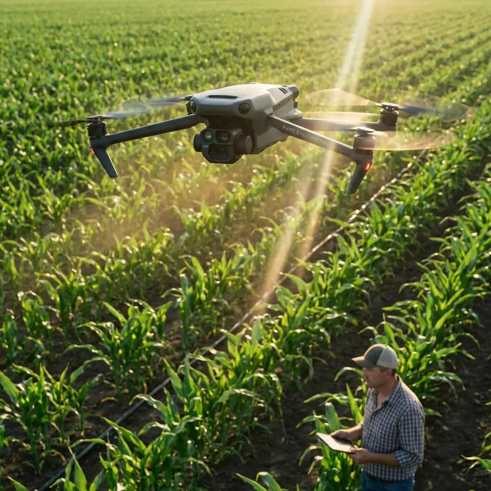
The Mission Profile
The survey area followed a coastal highway segment where salt air, reflective pavement, sparse vegetation, drainage shoulders, and occasional concrete barriers created a mixed visual environment. That matters because corridor work is rarely uniform. Unlike a compact stockpile or a single field block, a highway corridor stretches through changing surfaces and elevations. You are constantly balancing linear coverage, image consistency, and positional confidence.
For this job, the Mavic 3M was chosen not because it is fashionable, but because its multispectral capability offered more than a standard RGB capture could provide. On a highway job, that may sound unnecessary at first glance. It is not.
Multispectral data can help distinguish vegetated shoulders, drainage encroachment, stressed roadside cover, and moisture-related pattern changes that are easy to overlook in standard imagery. In coastal corridors, where runoff and roadside plant health can signal maintenance issues, that extra layer has operational value. It is not just about making a prettier orthomosaic. It is about making the dataset more informative for engineers, asset managers, and environmental teams who need to interpret what is happening beyond the asphalt edge.
Why RTK Fix Rate Was the Real Story
If there was one metric the crew watched most carefully that day, it was RTK fix rate.
Corridor mapping exposes weak workflows quickly. Small positional inconsistencies that might be tolerated in a broader-area visual map become much more obvious when you are trying to maintain centimeter precision along a narrow, elongated route. A dropped fix or intermittent satellite geometry issue can ripple through the deliverable. The highway itself acts like a ruler. Errors become easier to spot.
The Mavic 3M’s RTK-supported workflow mattered here because the client did not just want “close enough.” They needed repeatable geospatial alignment suitable for comparing future surveys against the current baseline. Coastal roads are maintenance-heavy assets. Subsidence, shoulder erosion, drainage failures, and vegetation intrusion all benefit from temporal comparison. If one survey cannot align cleanly with the next, the downstream value of the mission drops fast.
That is why I tell teams to stop thinking of RTK as a line item and start treating it as an operating condition. The fix is not merely technical reassurance. It determines whether the output can support change detection with confidence.
Mid-Flight Weather Shift: What Changed and What Didn’t
The day started clean enough. Light haze offshore, manageable wind, and a stable launch window. About halfway through the corridor, conditions changed. The breeze built unevenly and began pushing crosswise against the roadway. You could see it in the roadside vegetation before you felt it in the aircraft behavior. Then the moisture moved in.
This is where a lot of survey plans quietly fail. Not because the aircraft crashes or the mission aborts dramatically, but because the data quality degrades in subtle ways while the crew keeps flying as if nothing happened.
The Mavic 3M handled the shift well, but “handled it” needs to be defined properly. It does not mean the environment stopped mattering. It means the aircraft remained stable enough that the team could make informed adjustments instead of losing the mission entirely.
We tightened our attention on three things:
- Ground speed relative to image quality
- Overlap consistency through the windy section
- RTK status continuity
That trio matters more than bravado in coastal work. Wind does not have to be extreme to compromise a corridor survey. A modest crosswind can alter the aircraft’s behavior just enough to affect image geometry, especially over linear assets where consistency is everything.
The Mavic 3M’s stability gave us room to adapt rather than retreat. We adjusted the pass logic, monitored the aircraft’s hold more carefully during turns, and prioritized data integrity over raw speed. This is a useful distinction for teams under schedule pressure: finishing a mission is not the same as finishing with reliable inputs.
Multispectral in a Highway Context: Not Just for Agriculture
The Mavic 3M is often pigeonholed as an agriculture platform because “M” immediately makes people think multispectral and field scouting. That is too narrow.
On this coastal highway project, multispectral capture helped separate roadside conditions in a way RGB alone would not have delivered as clearly. Vegetated strips adjacent to drainage channels showed variation that could be correlated with moisture and stress patterns. In practical terms, that gave the asset team better context around where shoulder instability or blocked runoff might develop next.
This is one of the most underrated strengths of the Mavic 3M for infrastructure-adjacent surveys: it can bridge civil inspection and environmental observation in one workflow.
That does not mean every highway client needs a multispectral dataset every time. It means when the corridor has drainage sensitivity, erosion exposure, or vegetation-management implications, the additional bands can move the work from “map produced” to “maintenance insight generated.”
Swath Width, Corridor Logic, and Why Planning Beats Heroics
A lot of operators obsess over maximum coverage figures without thinking deeply about swath width in relation to corridor geometry. That is a mistake.
Highway work is not a broad-acre farm mission. The goal is not simply to cover as much area as possible in one launch. The goal is to cover the right width with enough consistency that road edges, shoulders, medians, barriers, and adjacent features reconstruct cleanly. Too narrow, and you create unnecessary passes and processing inefficiency. Too wide, and you risk collecting more irrelevant terrain while weakening your focus on the corridor itself.
On this job, swath width was treated as a design variable, not a default setting. That changed everything. It let the team match the flight plan to the road’s actual operational envelope, including runoff margins and vegetation zones that influence long-term maintenance.
This is where the phone-photography lesson from that 2026 article comes back in a useful way. The article was not a hardware review. It was a methods piece built around practical technique. Same here. The Mavic 3M performed well, but the result came from configuration choices that respected the assignment rather than from blind trust in the aircraft.
Coastal Conditions and Aircraft Confidence
Anyone who surveys near the sea learns quickly that the environment is less forgiving than inland sites. Salt-laden moisture, shifting gust patterns, and reflective surfaces create a different operational rhythm. You can have a mission that looks acceptable from a distance yet still contains gaps in the data logic.
This is why environmental resilience matters so much in platform selection. Teams working around exposed infrastructure often ask about ruggedness and weather tolerance in shorthand terms. They want to know whether the aircraft is going to become a liability when the air stops behaving nicely.
That is a fair question. It is also one reason buyers comparing field platforms often ask for practical guidance rather than brochure interpretation. If you need to talk through that kind of real-world setup, including RTK behavior, corridor planning, and payload fit for coastal surveys, I usually suggest starting with a direct conversation through this field support chat.
The broader point is that confidence in the aircraft changes crew behavior. When the platform remains composed, the team can focus on mission decisions instead of constantly compensating for the machine. That affects safety, data quality, and fatigue over the course of a long corridor.
What This Means for Repeat Surveys
The client’s real objective was not just a single map. They wanted a baseline that would still be valuable months later.
That is where centimeter precision and repeatability become more than technical bragging rights. A coastal highway is a living asset. Drainage patterns shift. Shoulders settle. Vegetation expands into right-of-way zones. If the original survey is not robust, repeat flights become harder to compare and trend analysis loses credibility.
The Mavic 3M fit this requirement well because it allowed the team to build a dataset with positional discipline and richer surface interpretation. RTK-supported accuracy reduced ambiguity. Multispectral data added context. Stable performance during the weather shift preserved continuity when lesser planning might have produced a patchwork result.
For infrastructure managers, that combination is practical, not academic. It means future surveys can answer more meaningful questions:
- Has roadside vegetation stress increased near drainage outlets?
- Are shoulder conditions changing in moisture-prone segments?
- Is the corridor behaving consistently after seasonal weather exposure?
Those are asset-management questions. And they are exactly the kind of questions a well-run Mavic 3M mission can help answer.
A Quick Note on the “Spray Drift” and “Nozzle Calibration” Confusion
Because some search terms around the Mavic 3M overlap with broader UAV operations, people sometimes arrive expecting agricultural spraying discussion, including spray drift and nozzle calibration. That is not what this aircraft is for, and it was not relevant to this highway job.
Still, there is a useful lesson hidden in those terms. In spraying, calibration discipline determines whether the operation is trustworthy. In mapping, the equivalent discipline shows up in flight planning, RTK verification, overlap selection, and environmental judgment. Different mission. Same professional standard. Small setup errors create large downstream consequences.
Final Assessment From the Field
The Mavic 3M proved its value on this coastal highway survey not because it made the mission easy, but because it kept the mission controllable when conditions became less cooperative.
Two details mattered most in operational terms.
First, the multispectral capability expanded the survey beyond simple visual documentation. It gave the client a better read on vegetated margins and moisture-related roadside conditions, which are highly relevant in coastal infrastructure maintenance.
Second, RTK-backed positional reliability supported the kind of centimeter precision required for repeat corridor surveys. That is what turns a one-off flight into a long-term monitoring asset.
And the weather shift told the rest of the story. Wind and moisture arrived mid-flight, the kind of change that exposes weak planning fast. The aircraft remained stable enough for the team to adjust intelligently, protect data quality, and finish with a dataset that could actually be used.
That is the standard worth caring about. Not whether a drone can fly on a perfect day, but whether it helps professionals keep their work credible when the day stops being perfect.
Ready for your own Mavic 3M? Contact our team for expert consultation.