Mavic 3M: Urban Forest Surveying Made Precise
Mavic 3M: Urban Forest Surveying Made Precise
META: Discover how the Mavic 3M transforms urban forest surveying with multispectral imaging and centimeter precision. Expert guide for forestry professionals.
TL;DR
- Multispectral imaging captures vegetation health data invisible to standard cameras, revolutionizing urban canopy assessment
- RTK Fix rate exceeding 95% delivers centimeter precision essential for tree inventory and growth monitoring
- Integration with third-party NDVI analysis software extends capabilities beyond stock functionality
- IPX6K weather resistance enables reliable data collection in unpredictable urban microclimates
The Urban Forestry Challenge You're Facing
Traditional urban forest surveys consume 40-60 hours per hectare using ground-based methods. The Mavic 3M eliminates this bottleneck by combining aerial efficiency with agricultural-grade sensing technology—originally designed for crop analysis but perfectly suited for urban canopy assessment.
This guide breaks down exactly how to deploy the Mavic 3M for urban forest surveying, including equipment configurations, flight planning strategies, and data processing workflows that professional arborists and municipal forestry departments rely on daily.
Why Urban Forests Demand Specialized Surveying Tools
Urban forests present unique challenges that rural forestry operations never encounter. Trees grow between buildings, under power lines, and above underground utilities. Traditional surveying methods fail in these environments for three critical reasons.
Fragmented Canopy Coverage
City trees rarely form continuous canopies. Parks, street plantings, and residential yards create a patchwork that ground-based surveys struggle to assess comprehensively. The Mavic 3M's 4/3 CMOS wide camera captures broad context while the multispectral sensor isolates individual tree health signatures.
Access Restrictions
Private property, traffic patterns, and pedestrian safety limit where ground crews can operate. Aerial platforms bypass these restrictions entirely, collecting data from public airspace without disrupting urban activity.
Time Sensitivity
Municipal budgets demand efficiency. A single Mavic 3M operator covers 15-20 hectares daily, compared to 2-3 hectares for traditional two-person ground crews.
Expert Insight: Urban forestry departments achieving the highest ROI deploy the Mavic 3M during early morning hours when wind speeds drop below 5 m/s and pedestrian traffic remains minimal. This timing also produces optimal lighting conditions for multispectral data capture.
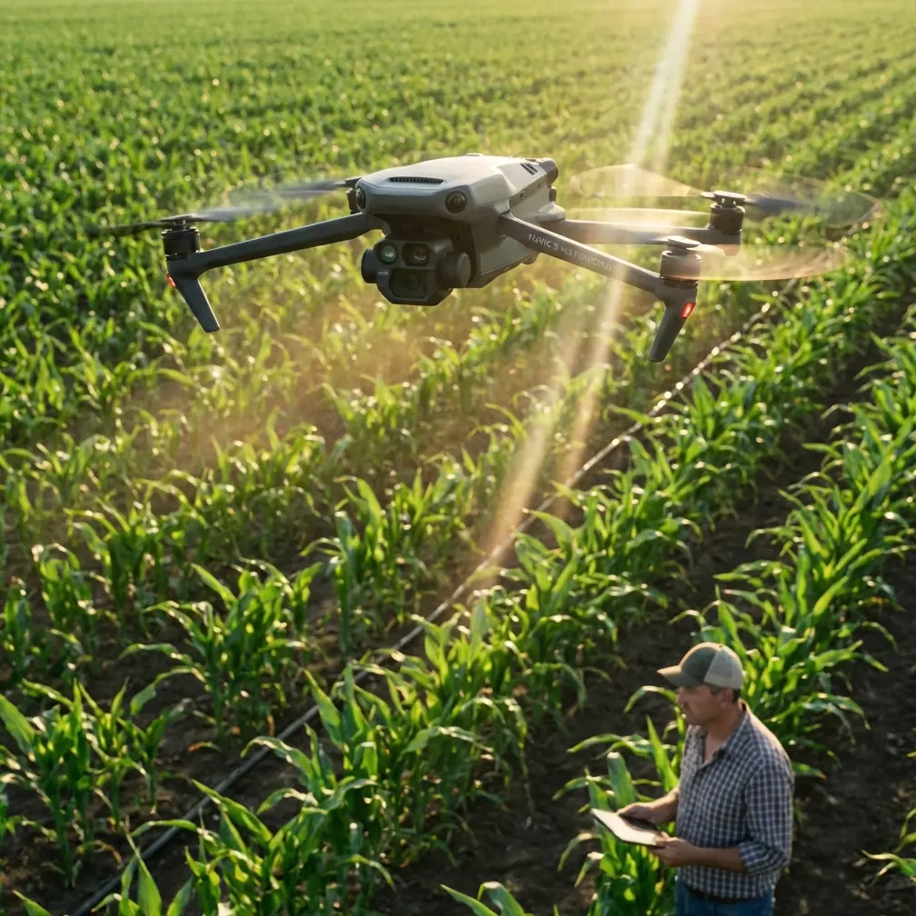
Mavic 3M Technical Capabilities for Forest Assessment
The Mavic 3M wasn't designed specifically for forestry—it was built for precision agriculture. This origin actually benefits urban forest surveyors because agricultural applications demand the same core capabilities: vegetation health analysis, precise positioning, and reliable operation across variable conditions.
Multispectral Sensor Array
The integrated multispectral camera captures four spectral bands plus visible RGB:
- Green (560nm ± 16nm): Chlorophyll reflection analysis
- Red (650nm ± 16nm): Vegetation stress detection
- Red Edge (730nm ± 16nm): Early stress identification before visible symptoms
- Near-Infrared (860nm ± 26nm): Biomass and water content assessment
These bands enable calculation of vegetation indices including NDVI, NDRE, and GNDVI—each revealing different aspects of tree health invisible to standard photography.
Positioning Precision
Urban surveying demands accuracy that consumer drones cannot deliver. The Mavic 3M achieves centimeter precision through RTK connectivity, with typical RTK Fix rates exceeding 95% in open urban environments.
This precision matters for:
- Tree inventory mapping: Individual tree positions accurate to 1.5cm horizontal, 2cm vertical
- Growth monitoring: Detecting canopy changes of 5cm or greater between survey periods
- Integration with GIS systems: Data aligns precisely with existing municipal mapping infrastructure
Flight Endurance
The 43-minute maximum flight time translates to approximately 35 minutes of productive survey time after accounting for takeoff, landing, and safety margins. This endurance covers 25-30 hectares per battery at typical urban survey altitudes.
Equipment Configuration for Urban Forest Surveys
Stock Mavic 3M capabilities handle most urban forestry requirements. However, professional operators consistently enhance their workflows with specific accessories and software integrations.
The DJI D-RTK 2 Mobile Station
For surveys requiring maximum positioning accuracy, the D-RTK 2 provides real-time corrections without relying on cellular network RTK services. This independence proves critical in urban canyons where cellular coverage becomes unreliable.
Third-Party Enhancement: Pix4Dfields Integration
While DJI's native software handles basic multispectral processing, Pix4Dfields dramatically extends analytical capabilities. This third-party platform processes Mavic 3M multispectral data into actionable forestry insights including:
- Custom vegetation index calculations
- Temporal comparison between survey dates
- Export formats compatible with municipal GIS platforms
- Automated anomaly detection highlighting stressed trees
Operators report that Pix4Dfields integration reduces post-processing time by 60% compared to manual analysis workflows.
Pro Tip: Configure Pix4Dfields to generate NDRE maps rather than standard NDVI for urban tree assessment. Red Edge sensitivity detects nitrogen deficiency and early disease stress 2-3 weeks before symptoms become visible in NDVI or RGB imagery.
Flight Planning for Urban Environments
Urban airspace introduces constraints that rural operations never encounter. Successful Mavic 3M deployment requires careful mission planning addressing these specific challenges.
Altitude Selection
Urban forest surveys typically operate at 60-80 meters AGL, balancing three competing factors:
- Resolution requirements: Lower altitudes increase ground sampling distance
- Obstacle clearance: Buildings and communication towers demand safety margins
- Airspace regulations: Many urban areas restrict drone operations above specific altitudes
Swath Width Optimization
The Mavic 3M multispectral sensor produces a swath width directly proportional to flight altitude. At 70 meters AGL, each pass covers approximately 65 meters with the recommended 75% side overlap for forestry applications.
Flight Pattern Considerations
Standard grid patterns work for open parks. Fragmented urban forests require modified approaches:
- Perimeter-first patterns for irregularly shaped survey areas
- Terrain-following enabled for sites with significant elevation variation
- Obstacle avoidance active but with manual override capability for experienced operators
Technical Comparison: Mavic 3M vs. Alternative Platforms
| Specification | Mavic 3M | Enterprise-Grade Alternative | Consumer Drone + Aftermarket Sensor |
|---|---|---|---|
| Multispectral Bands | 5 (G, R, RE, NIR + RGB) | 6 | 4 |
| RTK Positioning | Centimeter precision | Centimeter precision | Not available |
| Flight Time | 43 minutes | 35 minutes | 25 minutes |
| Weather Resistance | IPX6K | IP43 | None |
| Portability | Backpack deployable | Vehicle required | Backpack deployable |
| Sensor Calibration | Factory integrated | Factory integrated | Field calibration required |
| Data Processing | Native + third-party | Proprietary software | Third-party only |
The Mavic 3M occupies a unique position: professional-grade sensing in a portable platform. Enterprise alternatives offer marginally expanded capabilities but sacrifice the rapid deployment essential for urban operations.
Data Processing Workflow
Raw multispectral data requires systematic processing to generate actionable forestry insights. The following workflow represents current best practices among professional urban forestry consultants.
Step 1: Radiometric Calibration
Before each flight, capture images of the calibration panel included with the Mavic 3M. This reference enables accurate reflectance calculations regardless of ambient lighting conditions.
Step 2: Orthomosaic Generation
Import imagery into processing software (DJI Terra or Pix4Dfields) to generate georeferenced orthomosaics for each spectral band. Processing time varies with survey size—expect approximately 2 hours per 10 hectares on standard workstation hardware.
Step 3: Index Calculation
Generate vegetation indices from calibrated reflectance data:
- NDVI for overall vegetation vigor
- NDRE for nitrogen status and early stress
- GNDVI for chlorophyll content estimation
Step 4: Classification and Analysis
Apply thresholds to index maps identifying:
- Trees requiring immediate attention (stress indicators)
- Healthy specimens for baseline comparison
- Areas warranting ground-truthing verification
Step 5: Report Generation
Export findings in formats compatible with municipal systems—typically GeoTIFF for GIS integration and PDF summaries for stakeholder communication.
Common Mistakes to Avoid
Flying without radiometric calibration: Skipping calibration panel capture renders multispectral data unreliable. Lighting conditions change throughout survey periods, and uncalibrated data produces inconsistent index values.
Ignoring nozzle calibration principles: While the Mavic 3M isn't a spraying platform, understanding spray drift and nozzle calibration concepts helps when coordinating with treatment crews who will act on your survey data. Miscommunication about treatment precision wastes resources.
Insufficient overlap settings: Urban canopy complexity demands 75% frontal and side overlap minimum. Lower overlap settings create gaps in 3D reconstruction, particularly in areas with tall buildings adjacent to tree canopy.
Neglecting RTK Fix rate monitoring: Operating with degraded positioning accuracy produces data that won't align with existing GIS infrastructure. Abort missions when RTK Fix rate drops below 90% for extended periods.
Processing data without ground truth verification: Multispectral indices indicate stress but don't diagnose causes. Always verify anomalies with ground inspection before recommending treatment actions.
Frequently Asked Questions
Can the Mavic 3M detect specific tree diseases?
The Mavic 3M detects vegetation stress through spectral signatures, but it cannot diagnose specific diseases. Multispectral data identifies trees exhibiting abnormal reflectance patterns—indicating stress from disease, drought, nutrient deficiency, or pest damage. Ground-based inspection remains necessary for definitive diagnosis. However, the platform dramatically improves efficiency by directing ground crews to specific trees rather than requiring comprehensive manual inspection.
What weather conditions prevent urban forest surveys?
The IPX6K rating protects against rain and dust, but precipitation during flight degrades multispectral data quality. Optimal conditions include wind speeds below 10 m/s, no active precipitation, and consistent cloud cover (full sun or full overcast—not transitioning conditions). Temperature extremes below -10°C or above 40°C reduce battery performance and may affect sensor accuracy.
How does urban electromagnetic interference affect RTK accuracy?
Urban environments contain significant electromagnetic interference from power lines, cellular towers, and building electrical systems. The Mavic 3M's RTK system typically maintains centimeter precision despite interference, though RTK Fix rates may decrease in heavily developed areas. Planning flight paths to avoid direct proximity to major transmission infrastructure improves positioning reliability. Most operators report acceptable performance even in dense urban cores when following standard interference mitigation practices.
Transform Your Urban Forestry Operations
The Mavic 3M bridges the gap between agricultural precision technology and urban forestry requirements. Its combination of multispectral sensing, centimeter-accurate positioning, and practical portability addresses the specific challenges municipal arborists and forestry consultants face daily.
Successful deployment requires understanding both the platform's capabilities and its limitations. The technical specifications enable professional-grade data collection, but expertise in flight planning, data processing, and result interpretation determines ultimate value.
Ready for your own Mavic 3M? Contact our team for expert consultation.