Mavic 3M for Low-Light Field Surveying: Altitude
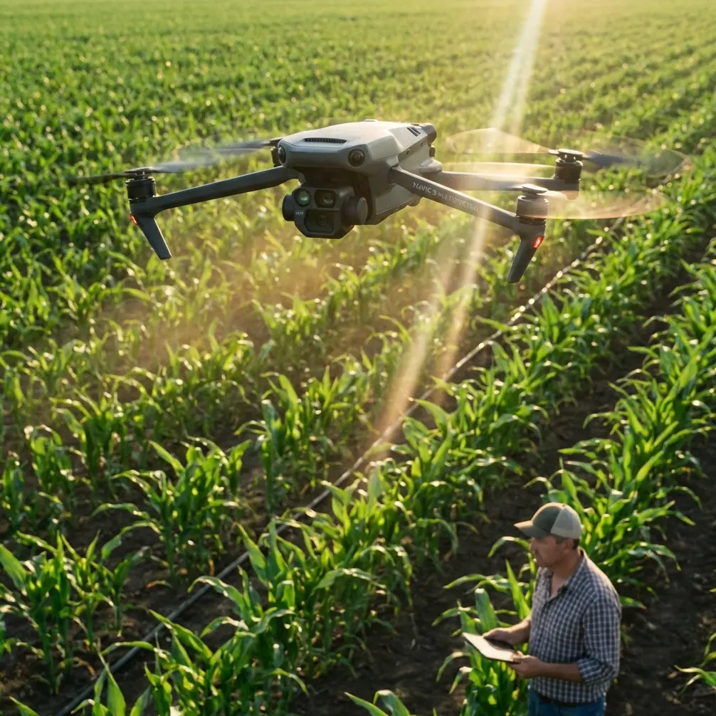
Mavic 3M for Low-Light Field Surveying: Altitude, RTK Discipline, and What Huzhou’s 300 Billion Vision Signals for Operators
META: Practical expert tutorial on using the DJI Mavic 3M for low-light field surveying, including optimal flight altitude, RTK fix strategy, multispectral workflow, and why Huzhou’s new low-altitude economy plan matters.
Low-light field surveying sounds simple until you try to produce data you can actually trust.
The Mavic 3M is often discussed as a multispectral tool for crop scouting, stand counts, drainage checks, and stress detection. That part is obvious. What matters in practice is whether the aircraft can deliver usable maps when daylight is fading, shadows are stretching across rows, and the window to fly is short. That is the real test for operators managing acreage on a schedule.
There is another reason this matters now. Huzhou has released a three-year low-altitude economy action plan aimed at building what it describes as four strategic “high grounds” for development. The targets are not small: by 2027, the city wants to attract or cultivate more than 10 leading or key enterprises, launch more than 100 projects valued above one hundred million yuan, and push low-altitude economic output past 30 billion yuan. For Mavic 3M users, those numbers are not abstract policy theater. They point to a larger operating environment where agricultural mapping, data collection, training, and regional drone service capacity are all moving from side activity to serious infrastructure.
If cities are planning around low-altitude operations at that scale, field teams need to tighten their methods. Low-light missions leave less room for sloppy altitude choices, weak RTK discipline, and poorly matched flight plans.
Why the Mavic 3M is relevant in a low-light field workflow
The Mavic 3M sits in an interesting place. It is compact enough to deploy quickly, but it is not merely a convenience platform. Its value comes from multispectral capture tied to precise positioning. That combination is what makes it useful when agronomists, growers, and farm managers need repeatable field intelligence rather than just aerial images.
For low-light work, the conversation should not start with “can it fly?” It should start with “can it maintain data consistency?” Those are different questions.
In dimmer conditions, a field can present several problems at once:
- row shadows become more pronounced
- soil and canopy contrast can shift quickly
- edge definition weakens in some parts of the field
- repeat missions become harder to compare if the flight geometry changes
This is why altitude is not just a coverage setting. It is a data-quality setting.
The altitude insight most operators miss
For low-light field surveying with the Mavic 3M, a practical starting point is 60 to 80 meters above ground level for most broad-acre crop assessments, with around 70 meters often giving the best balance.
Why that range?
Too low, and you gain detail but lose efficiency, widen the impact of shadow variation across each pass, and often end up with more stitching complexity than the mission really needs. Too high, and the ground sample detail may still look acceptable on screen, but subtle canopy variation becomes harder to separate from low-angle lighting artifacts.
Around 70 meters, many operators find a more stable compromise between:
- adequate swath width
- strong overlap for reliable reconstruction
- manageable mission time during short dusk or dawn windows
- enough image scale to preserve agronomic meaning
That altitude also helps when the goal is not artistic imagery but consistent map production over multiple dates. A wider swath width at a moderate altitude can reduce the number of turns and shorten the total mission. In low light, that matters. Every extra minute increases the chance that illumination changes across the field before the job is complete.
The key is not to worship one number. The key is to understand why moderate altitude is often safer than chasing maximum detail when lighting is unstable.
RTK fix rate matters more than most people admit
When people talk about the Mavic 3M, they often jump straight to multispectral output. That is only half the story. The map is only as reliable as its geometric consistency.
Low-light missions are less forgiving because the visual scene is already less stable. If your RTK fix rate is inconsistent, the workflow starts to drift in two ways at once: radiometric interpretation becomes less dependable, and spatial alignment gets harder to trust.
For agricultural operations, centimeter precision is not a marketing phrase. It is what allows you to compare drainage lines, weak-emergence strips, application zones, and recurring field boundaries from one mission to the next without introducing confusion. If an operator is trying to correlate imagery with nozzle calibration checks, irrigation issues, or suspected spray drift patterns, positional confidence becomes operationally significant.
A poor RTK fix rate can lead to results that look clean in a viewer but fail under field verification. That is the worst outcome because it wastes not just flight time, but agronomic decisions.
Practical RTK discipline for low-light flights
Do not launch until the RTK status is genuinely stable.
“Good enough” at takeoff often turns into “why doesn’t this line up?” in processing.Avoid changing altitude mid-mission unless terrain demands it.
Variable altitude in low light can alter both geometry and tonal consistency.Use repeatable takeoff procedures.
Same staging area, same mission logic, same overlap assumptions. That is how trends become believable.Check fix continuity, not just initial lock.
One strong moment before takeoff does not guarantee a strong mission.
Multispectral in low light: what changes operationally
Multispectral surveying is designed to reveal crop condition beyond what standard visual imagery can show. In lower light, though, your mission planning has to become stricter.
The Mavic 3M’s multispectral value is strongest when the captured data is comparable across time. In practical terms, that means your field maps should help answer questions like:
- Is this stress patch expanding?
- Is this drainage issue repeating in the same zone?
- Did the treatment area respond?
- Is stand variability linked to a recurring soil pattern?
If your low-light workflow varies wildly from one mission to the next, the maps may still look impressive, but their agronomic meaning gets weaker.
That is why I recommend operators standardize three things:
1. Flight altitude
Stick with a repeatable altitude band for similar crops and growth stages. Again, 70 meters AGL is often a strong default starting point for low-light broad-acre missions.
2. Overlap discipline
In lower light, stronger overlap gives processing more to work with. It adds time, yes, but it reduces the odds of weak reconstruction in uniform fields.
3. Time-window consistency
Do not compare one mission captured under a thin morning haze with another flown in late-day angled sun and assume the difference is all crop-driven. The mission window is part of the dataset.
Why spray drift and nozzle calibration belong in this conversation
At first glance, spray drift and nozzle calibration sound like topics for a spraying drone, not a Mavic 3M survey mission. That is too narrow a view.
The Mavic 3M becomes useful before and after application because it helps verify pattern outcomes across real field conditions. If an operator suspects off-target movement, uneven coverage response, or edge-of-field anomalies, multispectral and high-precision mapping can support a more disciplined assessment. Not as a guess from the road. As a documented field layer.
Nozzle calibration also enters the picture when variability appears in strips or across boom sections. A map captured with strong RTK performance and sensible altitude can help separate likely application-related issues from terrain, compaction, or irrigation factors.
This is where centimeter precision starts paying for itself. The more accurately you can position field symptoms, the easier it becomes to trace them back to likely causes.
Weather resistance and field realism
Field work rarely happens under studio conditions. Dew, fine mist, vehicle dust, and changing moisture are part of the operating environment. That is why ruggedness details such as IPX6K matter in the broader workflow discussion, even if they do not replace common-sense weather judgment.
Operators surveying fields early or late in the day often work around moisture-heavy conditions. Equipment resilience helps maintain schedule reliability, but it should not be confused with a free pass to fly in unsuitable weather. The real benefit is continuity. You can operate with more confidence in messy agricultural environments where clean benches and controlled conditions do not exist.
A sample low-light field mission setup
Here is a practical setup I would use as a baseline for the Mavic 3M when surveying fields in low light:
- Altitude: 70 meters AGL
- Goal: crop stress comparison, drainage pattern review, or treatment follow-up
- Priority: maintain RTK fix consistency across the entire mission
- Path design: minimize unnecessary turns, keep a clean grid, preserve strong overlap
- Timing: begin only when you can finish the field within a stable illumination window
- Post-flight review: verify alignment quality before drawing agronomic conclusions
If the field has strong topographic variation, then terrain-aware planning becomes more important than holding a rigid number. But on flatter acreage, 70 meters is a practical and repeatable center point.
What Huzhou’s plan means for Mavic 3M operators
The Huzhou announcement deserves attention because it reflects where the drone economy is heading operationally, not just politically.
A city does not set a target of more than 10 chain-leading or key enterprises, more than 100 major projects, and 30 billion yuan in industry scale by 2027 unless it expects real deployment capacity to grow around those targets. That growth affects pilot training, service standards, data expectations, and the sophistication of end users.
For Mavic 3M operators, that means two things.
First, agricultural and land-management clients will become more demanding. They will expect not just flights, but dependable outputs tied to actual decisions. Sloppy mission planning will stand out.
Second, regional low-altitude ecosystems are likely to reward teams that can bridge hardware and interpretation. Anyone can say “multispectral.” Fewer can explain why a mission flown at 70 meters with a strong RTK fix rate and repeatable timing gives better evidence than a quick ad hoc flight at a random altitude near sunset.
That is the difference between collecting images and building an operational service.
A sharper way to think about low-light surveying
If you are using the Mavic 3M in fields near dawn or dusk, do not frame the mission as a race against darkness. Frame it as a repeatability problem.
- Choose an altitude that protects consistency, not ego.
- Treat RTK fix rate as part of data quality, not a preflight formality.
- Use multispectral output to answer field questions tied to actual management actions.
- Respect how flight geometry, swath width, and illumination interact.
And if your team is building a workflow around this kind of mission profile, it helps to compare notes with people who work in these operational details every day. You can reach out here for a practical workflow discussion: message Marcus directly.
The Mavic 3M is not difficult to launch. The challenge is launching in a way that still makes sense when the map is on someone’s desk, the field crew is checking rows, and the agronomist wants answers instead of pretty colors.
That is where the aircraft earns its place.
Ready for your own Mavic 3M? Contact our team for expert consultation.