Mavic 3M for Urban Coastline Surveying: What Actually
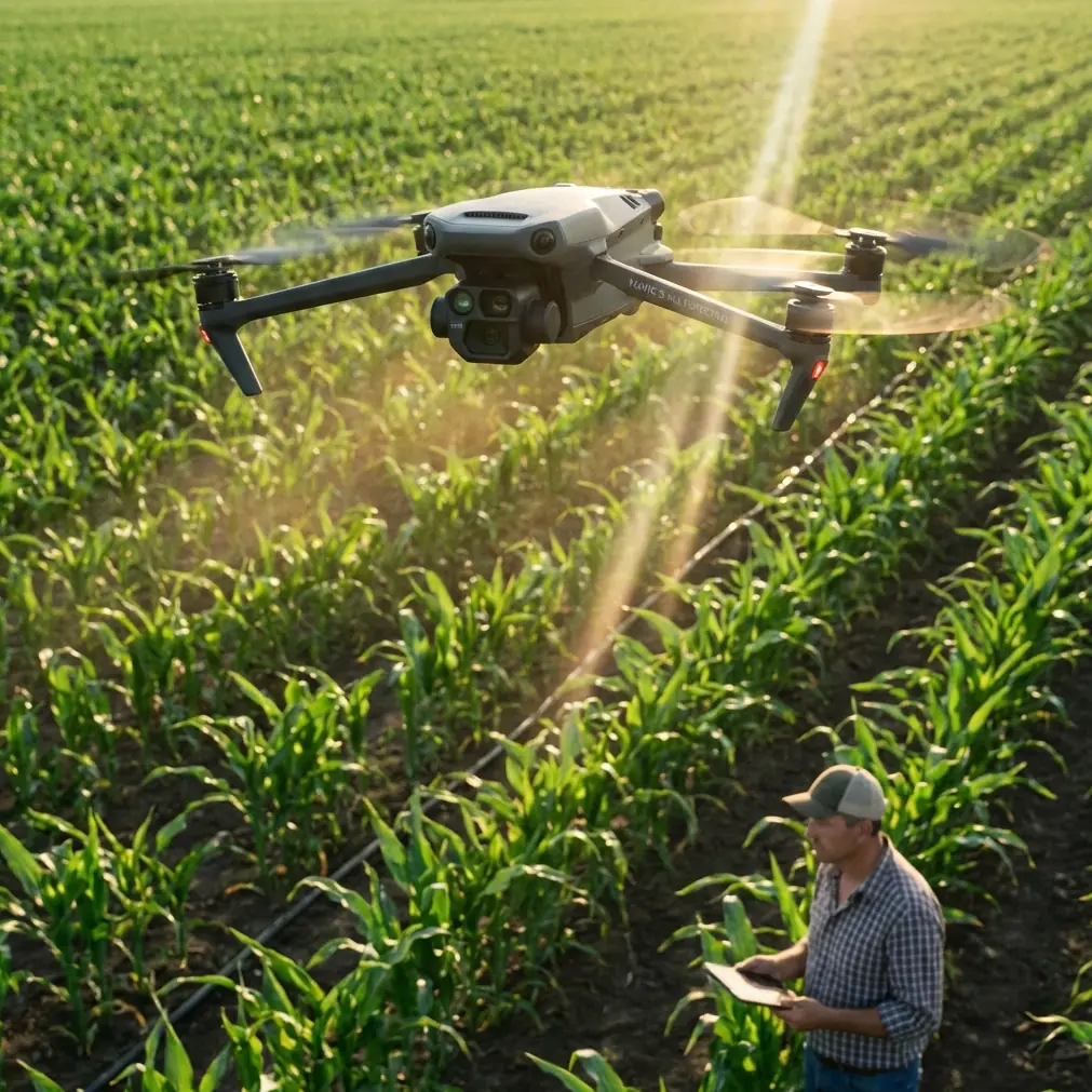
Mavic 3M for Urban Coastline Surveying: What Actually Matters in the Field
META: A technical review of the DJI Mavic 3M for urban coastline surveying, with practical insight on multispectral workflow, RTK expectations, flight automation, and why low-barrier control systems still shape real-world results.
Urban coastline surveying looks simple on paper. Water on one side, buildings on the other, and a flight plan stretched along the edge. In practice, it is one of the more demanding civilian drone environments you can throw at a compact mapping platform. Reflective surfaces, unstable GNSS behavior near structures, shifting light off the water, wind tunneling between buildings, and a long narrow area of interest all expose whether an aircraft is merely convenient or genuinely usable.
That is where the Mavic 3M becomes interesting.
Most people approach the Mavic 3M through its headline identity: a compact multispectral drone. Fair enough. But for urban coastal work, the more useful question is not whether it captures multispectral data. It is whether the aircraft’s design philosophy helps a survey team collect repeatable, decision-grade information with minimal friction. On that front, the story around DJI’s development history matters more than many buyers realize.
A key reason DJI became dominant, according to one industry business study, was its integration of GPS, camera systems, and flight control in a way that enabled automatic hovering and dramatically lowered the operating threshold for users. That sounds like old history until you apply it to the Mavic 3M. Urban shoreline missions benefit from exactly that legacy. Stable hover is not a convenience feature when you are checking edge conditions near seawalls, vegetation transitions, drainage outfalls, or erosion-prone sections. It is the difference between a clean re-acquisition of a target area and a sloppy second pass that introduces uncertainty into the dataset.
The same research also noted that DJI expanded the market by reducing complexity and pushing multirotor access far beyond the earlier DIY enthusiast crowd. For today’s Mavic 3M operator, that has an operational consequence: teams can spend less time wrestling with platform behavior and more time standardizing data capture. In coastal surveying, that means more attention on tide timing, control placement, reflectance consistency, and corridor overlap rather than pure stick skill.
That shift from difficult flying to structured workflow is not small. It is the foundation.
Why the Mavic 3M fits the coastline brief
The Mavic 3M makes the most sense when the mission is not just “map this area,” but “map this area repeatedly, with enough consistency to compare conditions over time.” Urban coastlines are living boundaries. Vegetation stress near saline intrusion, sediment movement after storms, standing water around built infrastructure, and degradation of managed green strips all benefit from repeat observation.
This is where multispectral capture stops being a niche checkbox and becomes practical. Standard RGB imagery will show visible change. Multispectral data can reveal earlier biological or surface condition signals that are not obvious to the eye. For coastal asset managers, environmental consultants, or infrastructure planners, that can support trend analysis along embankments, marsh margins, landscaped barriers, and drainage-adjacent vegetation.
The Mavic 3M also suits the physical geometry of these jobs. Coastlines in urban settings are usually corridor missions, not wide open block surveys. You are often tracing a narrow linear band with interruptions: piers, promenades, retaining walls, marinas, road crossings, and public access points. A compact aircraft is easier to deploy from constrained launch areas and easier to reposition between segments when pedestrian traffic or local restrictions complicate a single continuous sortie.
The real value of DJI’s automation lineage
Older DJI platform documents tell a revealing story. Phantom-era systems highlighted one-tap takeoff, automatic hover, return-to-home logic, and even stable low-altitude positioning in GPS-challenged environments through vision and ultrasonic sensing. One model promoted 720P real-time transmission and control confidence out to 2 km. Those specifics belong to an earlier generation, but they explain the DNA that modern enterprise users take for granted.
For Mavic 3M operators, that lineage translates into confidence at the exact moments when urban coastline work gets messy.
Take launch and recovery. A promenade launch point can be crowded. Wind can shift around hardscape. Salt-laden air can make teams want to get airborne efficiently and get back down without drama. Earlier DJI systems emphasized one-button takeoff and return logic because reducing pilot workload reduces error exposure. On the Mavic 3M, that same design philosophy supports disciplined operations: verify mission parameters, launch cleanly, let the system hold stable, and focus on sensor and mission execution.
That matters even more when you are trying to maintain a high RTK fix rate and consistent overlap along a waterfront corridor. Any unnecessary interruption in aircraft positioning or pilot-induced wobble can compromise the quality of a narrow swath survey. “Centimeter precision” is a phrase people throw around casually, but in coastal mapping it only matters if your workflow preserves it. Platform stability is part of that chain.
A field moment that says more than a spec sheet
On one urban shoreline vegetation assessment, the issue was not buildings or boats. It was a heron.
The bird had settled near a tidal outfall where stressed vegetation was one of the main survey targets. Anyone who works these spaces long enough knows wildlife can alter flight decisions in seconds. The aircraft was held off the area, repositioned, and the pass was resumed from a safer angle after the bird moved on. What stood out was not heroic piloting. It was the value of a drone that could hold predictably, resume methodically, and allow the operator to make a conservative decision without losing control of the mission.
That is the kind of thing users rarely mention in marketing copy, yet it shapes whether a platform is trusted. In environmental and infrastructure work, the best drone is often the one that lets the crew back off gracefully when the site changes.
Multispectral is only useful if the workflow around it is disciplined
Plenty of teams buy multispectral capability before they are ready to use it well. The Mavic 3M can produce valuable environmental information, but urban coastline conditions punish sloppy practice.
Water adjacency changes scene brightness fast. Salt spray and haze can affect image clarity. Reflective surfaces can distort operator judgment during visual review. If you are trying to compare shoreline vegetation health or moisture-linked stress over time, you need consistency in mission timing, altitude, overlap, and ground truth process. Swath width decisions matter too. Fly too wide and your corridor efficiency improves, but edge detail along the shoreline transition may become less reliable. Fly too tight and you may preserve detail while burning more battery cycles and field time.
This is also why the Mavic 3M tends to reward operators who think like surveyors, not hobbyists with better sensors. The platform is accessible, yes, but the output quality still depends on mission discipline.
A useful lesson appears in the business research on drone market evolution: the strongest future value often shifts away from the aircraft itself and toward services like data collection, data analysis, professional operations, and technical training. That framework fits the Mavic 3M perfectly. The drone alone is not the whole product in a coastline project. The value comes from mission planning, RTK setup, calibration habits, processing standards, and interpretation.
If your team is still refining those pieces, it is often more productive to discuss workflow design early rather than after the first disappointing dataset. For that kind of field-oriented conversation, you can message a coastline mapping specialist here.
Urban coastlines expose positioning truth fast
The reader scenario here mentions urban coastline surveying, so let’s talk about positioning in the real world rather than in clean brochure language.
A strong RTK fix rate is central when you need repeatable corridor products along infrastructure edges. Buildings can interfere with the sky view. Waterfront corridors sometimes force you into narrow launch windows. If you lose consistency in correction availability or mission geometry, your output may still look acceptable visually while degrading in measurable accuracy. That matters if the deliverable supports drainage planning, erosion monitoring, vegetation management, or construction coordination.
Centimeter precision is only meaningful when the whole mission supports it: antenna setup, control logic, flight pattern, overlap, and processing discipline. The Mavic 3M gives a compact team a credible path to that level of work, but no aircraft makes bad field habits disappear.
That is one reason the old DJI emphasis on lowering the operational barrier still matters. When the platform handles core flight behavior cleanly, the operator has more cognitive room for quality control. In a difficult environment, that can be the difference between noticing a drifting overlap pattern and missing it until the office.
What about “spray drift,” “nozzle calibration,” and IPX6K?
Those terms usually belong to agricultural spraying discussions rather than coastline mapping, and that distinction matters. The Mavic 3M is not being evaluated here as a spraying aircraft, so spray drift and nozzle calibration are not core mission variables for this use case. If your broader operation also manages vegetation treatment along coastal greenbelts, keep those workflows separate. Survey first. Treatment planning second. Do not blur the operational assumptions.
IPX6K is another term people often search when comparing field hardware durability. It signals concern about resistance to harsh environments, which is reasonable around salt air and waterfront mist. But durability ratings should never become a shortcut for weak maintenance habits. Coastal work demands basic discipline: inspect airframe surfaces, clean exposed components appropriately after missions, manage battery storage carefully, and monitor sensor surfaces for residue. A resilient platform helps. A careless operator still loses.
Why compact deployment can beat larger systems
There is a temptation to assume bigger aircraft always equal more professional outcomes. Urban shoreline work often disproves that. Compact deployment can be an advantage when access is fragmented and public-facing. A survey crew may need to launch from a narrow walkway, reposition between sections, or work around pedestrian flows without turning the jobsite into a spectacle.
This is where the Mavic 3M’s form factor earns its place. You get a platform that can move between segments quickly, capture environmental data beyond plain visual imagery, and support repeat missions without the overhead of a larger field package. For consultants and municipal contractors, that can reduce crew fatigue and improve the practicality of monthly or seasonal revisit schedules.
Again, this lines up with the broader market trend identified in the reference material: drone businesses increasingly create value not just by selling equipment, but by building service layers around professional operations and data products. A compact, reliable multispectral aircraft fits that model because it makes repeat service delivery easier.
The bigger lesson behind the Mavic 3M
One of the source materials described the drone industry’s high-growth phase as tied not only to technology but also to business model strength, service capability, and continued technical development over the next 5 to 10 years. That is a smart lens for evaluating the Mavic 3M today.
The aircraft matters, but what matters more is the maturity of the operational ecosystem around it.
DJI’s earlier breakthroughs were not just about making aircraft fly. They were about integrating systems so users could do useful work with less friction. Automatic hovering lowered the skill barrier. Ready-to-fly design removed assembly pain. One-tap flight functions reduced routine mistakes. Real-time video links improved decision-making. Those are not museum pieces in the company history. They are the reason a modern platform like the Mavic 3M can serve a technically serious job like urban coastline surveying without demanding a specialist test pilot at every launch.
For shoreline professionals, that translates into something very practical: more attention can go to environmental interpretation, corridor planning, and data consistency. Less gets wasted on basic aircraft management.
That is the right trade.
If your coastline mission depends on repeatable multispectral outputs, stable corridor execution, and deployability in tight urban waterfront conditions, the Mavic 3M is compelling not because it is flashy, but because it sits at the intersection of maturity and mobility. It inherits a decade of user-barrier reduction and applies it to work that actually benefits from that simplification.
That is why it belongs in the conversation.
Ready for your own Mavic 3M? Contact our team for expert consultation.