Mavic 3M in Dense Urban Vineyards: A Practical How
Mavic 3M in Dense Urban Vineyards: A Practical How-To for Precision Work When Conditions Shift
META: A field-tested how-to for using the Mavic 3M around urban vineyards, with lessons from Shenzhen’s drone enforcement rollout, weather shifts, multispectral planning, RTK precision, and drift control.
Urban vineyard work punishes sloppy drone planning.
Not because the rows are harder to see. Not because the terrain is always worse. The real challenge is that city-adjacent agriculture sits inside a tighter operating envelope: more roads, more parked vehicles, more pedestrians, more reflective surfaces, and less margin for drift, delay, or positional error. If you are evaluating the Mavic 3M for work around vineyards in these conditions, the machine matters less than the method.
A recent detail out of Shenzhen makes that point sharply. In Futian District, traffic authorities launched a district-wide drone swarm operation to document illegal parking, and vehicles captured by drone that did not move were subject to penalties. That is not an agriculture story on the surface. But for anyone flying near urban roads, it reveals something operationally significant: drones are no longer occasional tools in city airspace. They are active participants in routine urban management, and their use for evidence collection means flight discipline, route design, and ground awareness now matter more than ever for civilian operators.
For vineyard teams, especially those managing spray-related decisions in mixed urban edges, the lesson is simple. Treat every sortie as if the surrounding environment is already being observed, recorded, and managed by other drone users and by public authorities. The Mavic 3M can be extremely effective in this setting, but only if you build the workflow around precision, documentation, and adaptability.
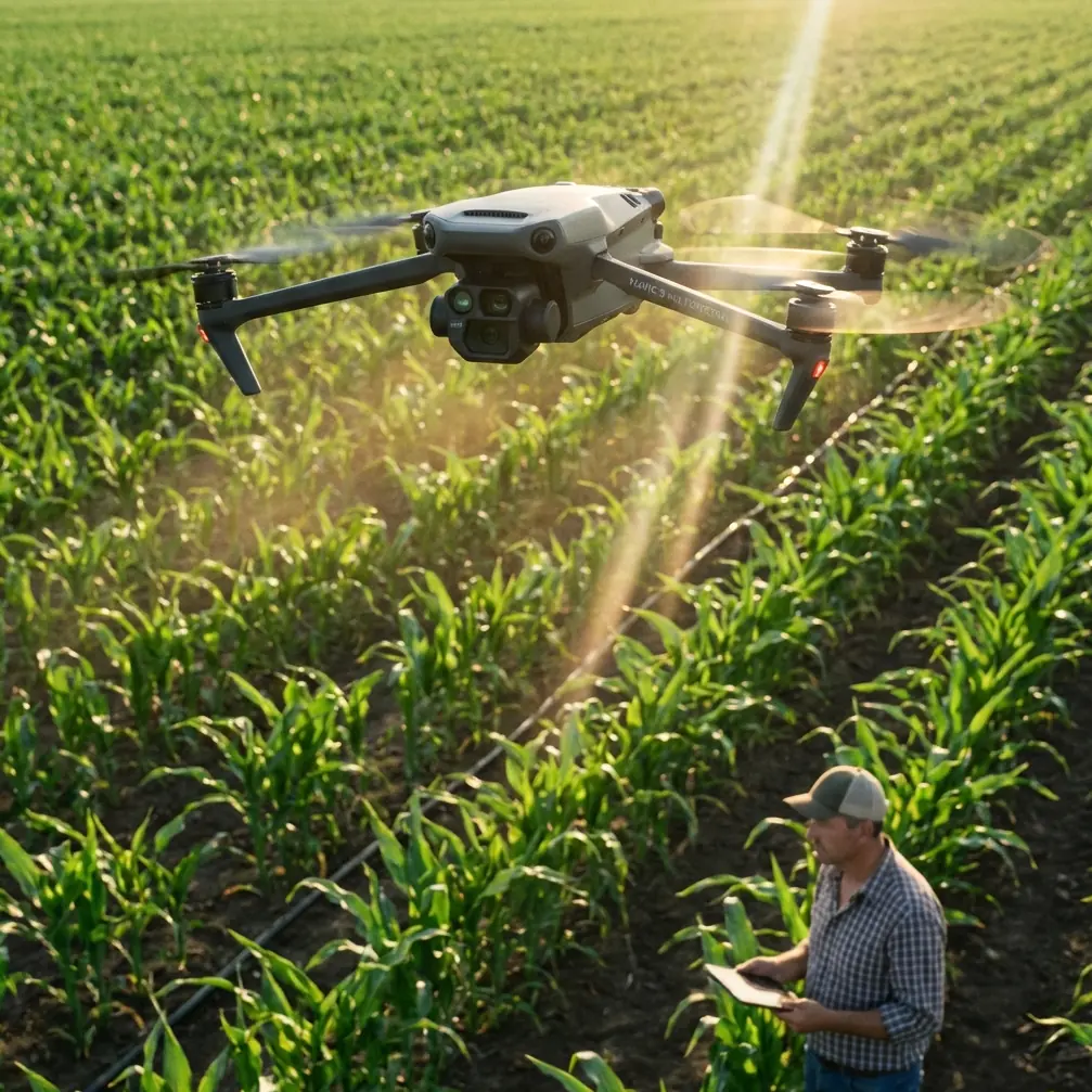
Start with the right premise: the Mavic 3M is a decision drone, not a spray drone
The first mistake I see in urban vineyard operations is role confusion.
The Mavic 3M is not the platform you choose because you want to push liquid over vines. It is the platform you choose because spraying without current, field-specific plant data is how drift, waste, and uneven coverage begin. In practical terms, the Mavic 3M earns its place before the spray mission starts. Its value is in identifying variation across the block, refining where intervention is justified, and tightening the treatment plan so the spraying platform can fly fewer unnecessary passes.
That distinction becomes more important in urban settings, where spray drift is not an abstract agronomy issue. Drift can reach roads, sidewalks, vehicles, building edges, or landscaped buffers. A vineyard bordered by urban infrastructure does not forgive broad assumptions. Multispectral intelligence helps convert a blanket application mindset into a zoned response.
This is where the Mavic 3M’s multispectral capability has real operational weight. You are not collecting imagery for a pretty map. You are building evidence for where vigor is weak, where stress patterns suggest poor uptake, and where a full-width treatment may need to be narrowed or delayed. When the swath width on the spray side is being planned, those crop intelligence layers let you reduce exposure in borderline areas instead of flying the entire parcel as if every row is equally needy.
Why Shenzhen’s drone enforcement story matters to vineyard operators
The Shenzhen case gives us two useful signals.
First, authorities in one major urban district did not deploy a single aircraft for occasional checks. They launched a “drone swarm” campaign across the entire district. Scale matters. It tells us drone activity in city environments is becoming normalized, coordinated, and persistent.
Second, enforcement depended on visual capture and follow-up action if the vehicle remained in place after documentation. That means the drone was not merely observing; it was part of a process designed around verifiable records and time-sensitive response.
For Mavic 3M operators, this changes how you should think about your own missions near roads and access points. If your vineyard edge runs alongside public streets, then illegally parked vehicles, delivery vans, service traffic, or temporary obstructions are not just annoyances. They are mission variables. A blocked access lane can alter launch placement. A vehicle stopped near the spray boundary can trigger a delay. A congested shoulder can increase public exposure if rotor wash or drift moves outward. In other words, urban operations demand the same respect for documentable conditions that Shenzhen’s traffic team is applying to curbside enforcement.
Before launch, inspect road-facing edges with intent. Do not just ask, “Is the field clear?” Ask:
- Is there any parked vehicle along the downwind boundary?
- Has temporary traffic changed the safest takeoff point?
- Do access routes for support crew remain open if weather turns?
- Will your intended path bring the aircraft into visual conflict with another low-altitude drone user?
These are not theoretical questions anymore.
A practical Mavic 3M workflow for urban vineyard missions
1. Build the mission around the weather window, not the calendar slot
Urban microclimates are fickle. Buildings channel gusts. Asphalt radiates heat. Narrow corridors between structures can pull wind in a direction that does not match the broader forecast.
On one urban-edge vineyard assessment, the morning began with stable air and manageable wind. Mid-flight, conditions changed. A crosswind picked up from the road-facing side, and the vine canopy nearest the perimeter started showing visible movement. This was exactly the kind of moment that separates a disciplined Mavic 3M operator from someone who relies on habit. The aircraft itself handled the shift well, but that was not the whole story. The crew adjusted altitude, tightened the mission logic, and treated the weather event as a data quality issue rather than just a piloting issue.
That matters because multispectral collection depends on consistency. If the aircraft can maintain the route but the environmental conditions are degrading the usefulness of the imagery, pressing on blindly creates false confidence. In urban vineyards, weather shifts do not only influence flight safety. They affect whether the resulting map is reliable enough to drive nozzle calibration and spray-zone decisions later.
So the rule is straightforward: if mid-flight weather changes enough to threaten stable interpretation, pause, reassess, and refly the affected portion under better consistency.
2. Prioritize RTK fix integrity before chasing speed
People love fast missions. They should love repeatable missions more.
When you are using the Mavic 3M to define treatment zones in vineyards with narrow row spacing and hard boundaries near roads, centimeter precision is not a luxury phrase. It is what keeps your agronomic map aligned with physical reality. Poor positional confidence near the urban edge can shift the interpreted boundary of stressed vines toward non-target space, which then distorts the work handed off to the spray team.
That is why RTK fix rate deserves more attention than mission speed. If the aircraft is not holding a strong positional solution consistently, you may still get a map, but the utility of that map for precise operational planning weakens. In a rural interior block, small alignment drift may be tolerable. In an urban vineyard, those same errors can affect where you think the treatment line should stop.
The operational significance is direct: better RTK performance means cleaner zone definition, more reliable row-level comparison over time, and less guesswork when building a narrow, defensible spray plan near roads or structures.
3. Use multispectral results to shrink the spray problem
This is where the Mavic 3M saves more trouble than any broad discussion of “efficiency” ever captures.
Once the imagery is processed, look for patterns that actually change action. Do not just identify weak areas. Separate them into categories: probable stress from irrigation inconsistency, traffic-edge compaction, shadow-related underperformance, or localized disease pressure requiring closer scouting. Urban vineyards often contain edge effects that look agronomic but are caused by infrastructure. If a roadside row is underperforming, it may not need the same response as an interior row with a different stress signature.
That changes how you set the spray swath width and treatment extent on the application platform. Instead of treating every edge row equally, you can tighten the plan and reduce exposure where conditions do not justify blanket coverage. This is one of the cleanest ways to limit spray drift risk without oversimplifying the agronomy.
4. Recheck nozzle calibration after environmental change
If weather changed during the Mavic 3M assessment, assume your downstream spray assumptions need review too.
Nozzle calibration is often treated like a routine setup item. In urban vineyard work, it should be treated as a live control variable. A shift in wind speed or direction can make a previously acceptable droplet profile less suitable, particularly along the outer rows closest to roads or neighboring properties. The intelligence from the Mavic 3M does not replace this step; it sharpens it. Once the multispectral map identifies exactly where treatment pressure is needed, calibration can be matched to a narrower objective rather than a whole-block default.
The practical payoff is substantial: fewer unnecessary passes, better deposition where it matters, and less chance that drift becomes the defining outcome of the day.
The urban edge changes your ground protocol too
The Shenzhen traffic case also highlights something many agricultural crews underestimate: ground conditions around roads are dynamic, and drones can make those conditions more visible to everyone.
If a city district can use drones to document curbside violations at scale, then operators working nearby should expect public attention, changing traffic patterns, and less tolerance for loosely organized field activity. For vineyard teams, this means your staging area must be as disciplined as your flight plan. Vehicles should not block access. Support equipment should stay tight to the operational footprint. Spotters should understand both airspace awareness and public-interface responsibilities.
That is not bureaucracy. It is operational resilience.
A messy launch area creates delays when weather shifts. A blocked support vehicle becomes a bigger problem when the wind turns and you need to relocate. And if you are operating near streets where traffic authorities already use drones actively, then your own professionalism becomes part of the safety environment.
What the Mavic 3M does especially well in this scenario
Three qualities matter most in urban vineyard support work.
First, it gives you a multispectral view that is useful enough to drive action rather than vague enough to invite over-treatment. That is the difference between “interesting imagery” and actual decision support.
Second, when supported by a solid RTK workflow, it can hold the centimeter-level positional consistency needed for repeat surveys and tight boundary planning. In vineyards with narrow margins between productive canopy and public edge space, that precision is not just nice mapping practice. It helps keep treatment logic inside the lines.
Third, the platform is practical enough to deploy quickly when the weather opens briefly, then recover fast if conditions sour. That flexibility matters because urban-edge weather often changes mid-mission. A drone that can be integrated into a disciplined stop-and-reassess workflow is more useful than one that encourages operators to force a mission through bad conditions.
If you are trying to refine your own setup or compare mission planning options for dense urban blocks, a direct line for technical discussion can help: message the flight planning team here.
A field rule worth keeping
When readers ask me how to use the Mavic 3M around vineyards near built-up areas, they usually expect a settings list. Those lists have value, but they are not the main thing.
The main thing is this: urban vineyard operations reward operators who reduce uncertainty before liquid ever leaves a nozzle.
Shenzhen’s district-wide use of drones for parking enforcement shows how normal drone-based observation has become in dense city environments. That one fact should change your mindset. You are not flying in a quiet agricultural bubble. You are flying in an active, managed, documented environment. The Mavic 3M fits this reality well because it helps you make earlier, tighter, more defensible decisions: where stress is real, where the treatment zone should begin and end, and where weather or boundary conditions justify delaying action.
Used that way, the aircraft becomes more than a mapping tool. It becomes the planning layer that keeps urban vineyard work precise, restrained, and operationally credible.
Ready for your own Mavic 3M? Contact our team for expert consultation.