Mavic 3M in Remote Vineyards: What Changes When Low
Mavic 3M in Remote Vineyards: What Changes When Low-Altitude Rules Finally Catch Up
META: A technical review of the DJI Mavic 3M for remote vineyard operations, with practical insight on multispectral scouting, RTK precision, spray planning, drift control, and why 2026 low-altitude regulation changes matter.
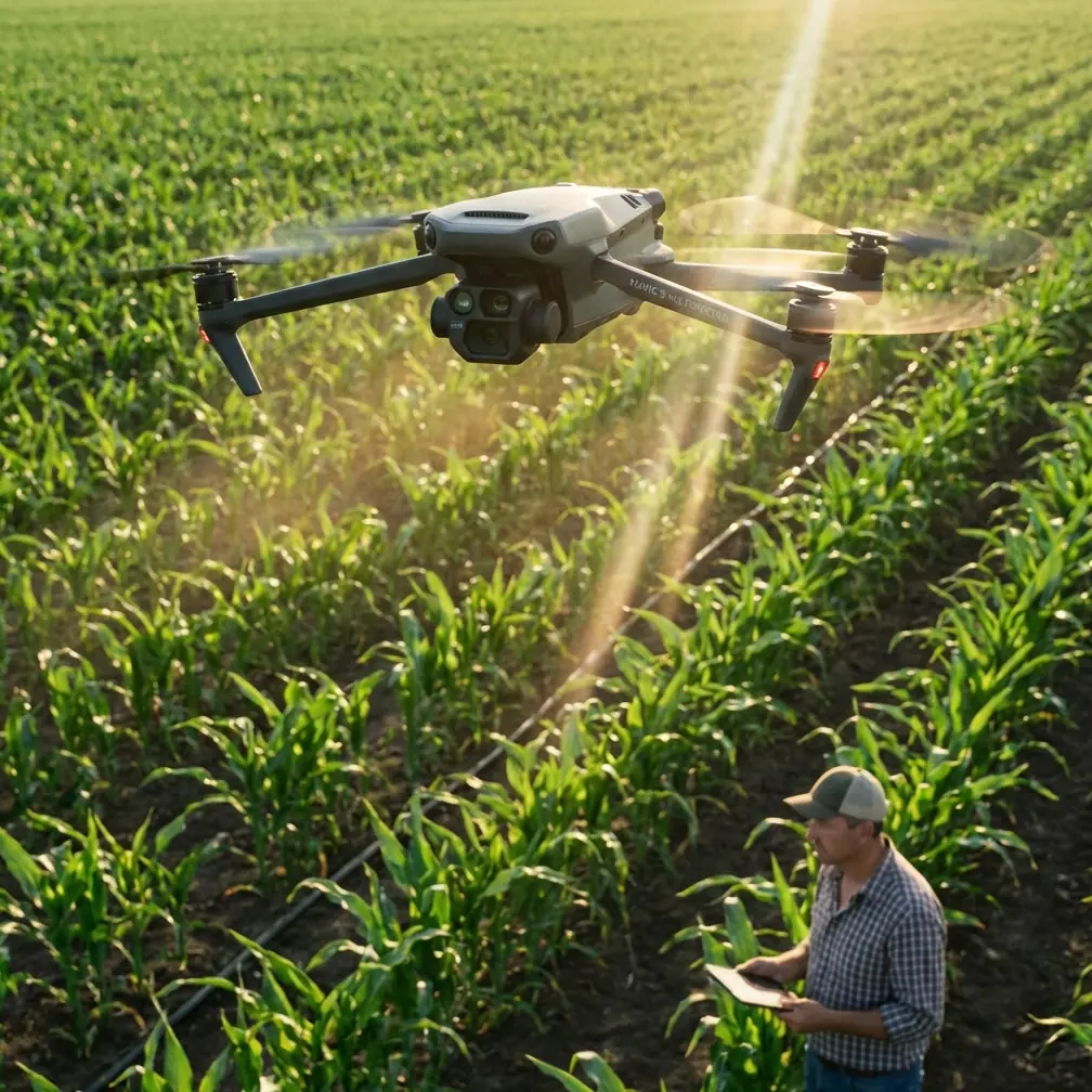
Remote vineyard work exposes every weakness in an aerial workflow.
Not the glamorous weaknesses. The real ones. Delayed approvals. Uneven local rules. Missions that look simple on a map but break down once terrain, distance, and timing enter the picture. For growers working steep rows far from road access, the aircraft is only half the equation. The other half is whether the operation around it is mature enough to support repeatable, legal, timely flights.
That is why the latest discussion around China’s low-altitude economy heading toward “normal operations” by 2026 matters even for a platform like the Mavic 3M. The headline is not just policy. The bigger shift is operational. An industry long slowed by difficult approvals, long cycles, and inconsistent regional oversight is being pushed toward standardization and rule-based execution. One example from the reference material stands out: a route of only a few dozen kilometers could previously take more than 10 days to approve. That kind of lag is catastrophic in agriculture, where disease pressure or irrigation stress can intensify in a fraction of that time.
For vineyard managers, agronomists, and service providers, the Mavic 3M sits right at the intersection of that transition. It is not a spraying drone, and that distinction matters. It is a scouting and decision-support aircraft. But in remote vineyards, better scouting often determines whether spraying is surgical or wasteful, timely or late, compliant or risky.
This is where the aircraft earns its place.
The Mavic 3M’s real job in vineyard spraying is before the spray mission
A lot of people approach the Mavic 3M from the wrong angle. They look at it and ask whether it can replace an ag spray platform. It cannot. That misses the point.
In vineyard operations, especially in remote blocks where access is slow and manual scouting is inconsistent, the Mavic 3M is best understood as the aircraft that tells you where, when, and how much intervention is justified before a sprayer ever lifts off or a tractor enters the row.
Its value starts with multispectral imaging. In vineyards, canopy uniformity is deceptive from the ground. A block can look visually healthy while carrying patchy vigor, water stress, nutrient imbalance, or early disease signatures that haven’t become obvious to the eye. Multispectral data changes that by exposing variation at row scale. That matters operationally because vineyards rarely fail uniformly. Problems usually cluster by slope, irrigation zone, wind exposure, drainage line, or trellis condition.
When you combine multispectral scouting with centimeter precision through RTK-enabled workflows, the result is more than a pretty map. It becomes a treatment planning layer. If your spray contractor or in-house team needs to prioritize edge rows, weak vigor sections, or blocks with suspected pressure, the Mavic 3M can identify those zones before the chemical truck leaves the yard.
That is not a minor efficiency gain. In remote terrain, it cuts wasted trips, reduces unnecessary passes, and supports more disciplined nozzle calibration decisions because the target condition is clearer.
Why the 2026 low-altitude shift matters to Mavic 3M operators
The reference article frames 2026 as the point where China’s low-altitude economy moves from a pilot-phase mindset into normalized operations, with drones and eVTOLs as core carriers for logistics and regional mobility. For agriculture, the relevance is less about urban mobility and more about what “normalized” actually means: policy, standards, and legal structure working together instead of forcing every operator to navigate a patchwork.
That has direct significance for vineyard service providers using the Mavic 3M in rural and mountainous areas.
Historically, three pain points were identified: approvals were hard to obtain, approval cycles were long, and supervision was messy or inconsistent. Add uneven standards across regions and slow emergency-flight response, and you get a fragmented operating environment. Agriculture hates fragmentation. Crop windows are short. Disease pressure doesn’t wait for paperwork. Wind conditions change by the hour. If one county interprets procedures one way and another county does something entirely different, scaling a drone service business across vineyard regions becomes much harder than the aircraft itself would suggest.
The Mavic 3M benefits disproportionately from a standards-led environment because it is often deployed as a frequent, lightweight, repeat-mission aircraft. That means its business value depends on routine use. If low-altitude operations shift from ad hoc approval logic to more predictable, legally structured access, then routine vineyard scanning becomes easier to schedule as part of agronomic management rather than as an exceptional event.
That is the deeper operational significance of the 2026 forecast. It is not abstract policy language. It is the difference between “Can we get permission in time?” and “This block is on the Wednesday rotation.”
In remote vineyards, precision is not a luxury feature
The terrain tells the story.
A remote vineyard is rarely flat, uniform, or forgiving. You may be flying over broken topography, narrow access roads, terraces, mixed canopy density, and changing wind behavior between ridgelines and lower rows. In that environment, centimeter precision is not marketing fluff. It is the foundation for repeatability.
When operators talk about RTK fix rate, they are usually thinking about whether the aircraft locks in quickly and stays stable enough to produce reliable overlap and map alignment. In vineyards, that consistency matters for trend analysis over time. If you are comparing canopy vigor week to week, looking for stress spread after a hot spell, or validating whether a targeted application had the intended effect, loose positional consistency can muddy the dataset.
A clean RTK workflow helps in three practical ways:
Repeatable missions over the same rows
You are not just mapping a vineyard once. You are revisiting it. Reliable positioning makes temporal comparison more trustworthy.Better alignment with ground actions
If a multispectral map flags a stressed section in the upper western edge of a block, the spray team, scout, or irrigation crew needs to find that exact zone without guesswork.Improved planning for variable intervention
Even when the spray platform itself does not use a variable-rate prescription in the narrowest sense, the Mavic 3M still helps teams divide a block into treatment priorities with confidence.
That last point is especially relevant when chemical availability, labor, or weather windows are limited. Precision in scouting supports precision in resource allocation.
Multispectral is useful only if you translate it into spray decisions
A vineyard manager does not need another map. They need fewer bad decisions.
This is where a lot of Mavic 3M workflows stall. The aircraft captures useful multispectral data, but the team never builds a disciplined bridge from imagery to action. In remote vineyards, the best operators build that bridge around a few recurring questions:
- Which rows actually need intervention first?
- Is canopy variability severe enough to justify segmented spraying?
- Are weak signatures tied to water, nutrition, disease, or simple shadow effects?
- Should swath width and route planning change because vigor and canopy mass differ across the block?
- Is there enough confidence in the data to recalibrate nozzles or reduce blanket coverage?
These are not software questions. They are agronomy-and-operations questions.
For example, if the Mavic 3M identifies lower-vigor zones on exposed upper slopes, the response might not be “spray more.” It may indicate irrigation inconsistency, wind stress, or shallow soil. Conversely, if multispectral signatures and visual confirmation suggest early pressure in dense, humid lower rows, then a targeted fungicide plan becomes more defensible. In both cases, the aircraft does not replace field knowledge. It sharpens it.
Spray drift is where good planning saves money and crop quality
Anyone spraying vineyards in remote areas knows how quickly drift turns into a quality issue.
Vines are often planted in complex terrain where microclimates shift over very short distances. Crosswinds can accelerate along gaps, slow near tree lines, and curl unpredictably around slope breaks. If the scouting layer is weak, teams tend to compensate by overapplying or treating too broadly. That usually increases drift exposure rather than reducing it.
The Mavic 3M helps earlier in the chain. By identifying where canopy density and crop condition truly differ, it enables tighter treatment zones. That reduces unnecessary passes. Fewer unnecessary passes mean fewer opportunities for drift.
The practical sequence is straightforward:
- Map the block and isolate real problem areas.
- Confirm whether those zones need treatment or another intervention.
- Adjust the spray mission plan around canopy condition, row orientation, and local wind behavior.
- Revisit afterward to evaluate whether the response worked.
This is also where nozzle calibration comes back into the conversation. Calibration should not be treated as a one-time machine setup. In vineyards, especially when moving between blocks with very different canopy characteristics, calibration needs to reflect target density, droplet behavior, and desired penetration. The Mavic 3M will not calibrate your spray nozzles for you, but it gives you better evidence for why the calibration and route plan should change from one parcel to the next.
A third-party accessory that actually expands the platform’s usefulness
One of the more practical ways teams have extended the Mavic 3M in remote vineyards is through third-party field integration gear rather than trying to force the aircraft into roles it was never designed for.
A simple but meaningful example is a high-visibility strobe accessory used for long visual tracking in broken terrain and variable light. On paper, that sounds minor. In the field, it can be the difference between smooth line-of-sight monitoring and awkward repositioning on steep access paths. In remote vineyards with irregular terrain and partial tree cover near row ends, keeping better visual awareness of the aircraft improves crew coordination and reduces mission friction.
That kind of accessory does not change the sensors or flight controller. What it changes is usability. And usability is often what determines whether an aircraft becomes part of a weekly operational routine or sits in a case waiting for perfect conditions.
If you’re trying to tailor a vineyard workflow around accessories, payload handling, or RTK setup, it helps to discuss the configuration with someone who understands agricultural mapping use rather than generic drone retail. A direct line like vineyard workflow support on WhatsApp is often faster than trading emails while a weather window closes.
Remote vineyard operators should think in systems, not aircraft
The most mature Mavic 3M users in agriculture are not obsessed with the aircraft itself. They think in systems.
They look at:
- approval and compliance pathways,
- repeatable mission templates,
- RTK base or network reliability,
- row-level interpretation of multispectral data,
- handoff between mapping and spray teams,
- post-treatment verification.
That systems approach is exactly why the 2026 regulatory direction described in the reference material is so relevant. The article argues that low-altitude development will be pushed forward by policy, standards, and rule of law together, moving the sector away from disorderly expansion and toward standardized, higher-quality growth. That is exactly the environment a platform like the Mavic 3M needs to deliver its full agricultural value.
Why? Because the aircraft is most useful when it flies often, predictably, and as part of a documented decision cycle. If operators are constantly struggling with inconsistent local interpretation or long route approvals, the technology underperforms through no fault of its own. Standardization fixes that bottleneck. It turns aerial scouting into a routine management layer.
My technical take: where the Mavic 3M fits best
As a consultant, I would not position the Mavic 3M as the star of vineyard spraying. I would position it as the aircraft that makes spraying smarter.
Its best use case in remote vineyards is not replacing high-capacity application platforms. It is reducing uncertainty before and after application. It tells you which blocks deserve urgent attention, which rows need a closer look, whether the intervention map should be tightened, and whether the treatment likely changed canopy response on the next pass.
That makes it especially strong for operators dealing with:
- fragmented remote parcels,
- difficult access,
- inconsistent canopy vigor,
- narrow weather windows,
- pressure to reduce drift and wasted coverage,
- the need for documented agronomic decisions.
And as low-altitude operations move closer to normalized execution rather than one-off exception handling, this kind of aircraft becomes more valuable, not less. The less time teams spend fighting process friction, the more value they can extract from the data.
For remote vineyards, that is the real story. Not the drone alone. The drone inside a maturing operating environment.
Ready for your own Mavic 3M? Contact our team for expert consultation.