Mavic 3M Workflow Lessons for Urban Power
Mavic 3M Workflow Lessons for Urban Power-Line Corridor Work: Precision Habits That Prevent Expensive Mistakes
META: A field-focused tutorial for Mavic 3M operators working around urban power-line corridors, with practical lessons on exposure control, visual positioning logic, precision flight habits, and drift-aware planning.
Urban utility corridors punish sloppy drone habits.
That was the real lesson from one of our early vegetation-management surveys near distribution lines running behind apartment blocks and roadside trees. The aircraft itself was capable. The problem was the operator workflow. Reflective rooftops pushed the image too bright, tree shade buried detail, and waypoint confidence dropped whenever the pilot treated the live view like a perfect representation of the scene. In dense urban work, that assumption costs time.
If you are using a Mavic 3M around power-line environments, especially for civilian inspection, corridor mapping, vegetation assessment, or pre-spraying planning, the biggest gains rarely come from a dramatic setting buried in a menu. They come from two simpler disciplines: getting exposure under control and understanding how the aircraft interprets position in relation to visible references.
Those ideas sound basic. They are not. They are the difference between a clean, repeatable data capture and a sortie that has to be flown again.
Why the Mavic 3M is only as good as the operator’s visual discipline
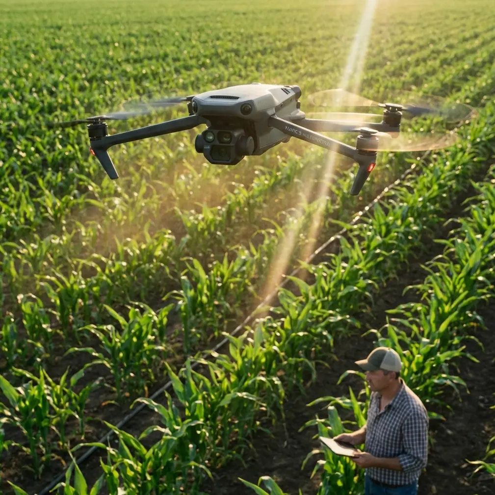
The Mavic 3M has a strong reputation because it combines efficient flight with data-grade imaging, including multispectral capability that supports crop and vegetation analysis. Around urban power lines, that matters for identifying encroachment patterns, stressed vegetation, and corridor maintenance priorities without sending crews into every site first.
But multispectral value depends on consistency.
If the visible image is poorly managed, operators often make bad decisions before the data ever reaches processing. They misjudge branch separation from conductors. They clip highlights on pale rooftops or concrete. They underexpose shaded easements beside buildings. Then they wonder why the mission felt less precise than the aircraft specification promised.
One of the most useful reminders actually comes from a very simple phone-photography technique: tap the screen, bring up the focus box, and use the small “sun” icon to adjust brightness. That reference was written for everyday smartphone users, but the operational lesson carries over cleanly to Mavic 3M fieldwork. Human eyes adapt dynamically. Camera systems do not. A scene that looks balanced to you can still record too dark or too bright.
That matters near power lines because urban backgrounds are uneven by nature. White walls, reflective cars, dark tree canopies, and narrow service alleys all sit in one frame. If you do not actively manage exposure, the live view will lie to you just enough to create avoidable errors.
The “small sun” mindset: exposure correction is not cosmetic
On a phone, the article’s point was straightforward: photos often come out darker or brighter than what the eye sees, and the fix is to tap the subject and adjust the little sun-shaped exposure control. For Mavic 3M users, think of this as a field habit rather than a phone trick.
Before flying an urban corridor segment, stop treating exposure as something only photographers care about. It directly affects mission quality in three ways.
1. It changes how well you can visually confirm conductor clearance zones
When shadows under trees collapse into black, branch structure disappears. When bright surfaces blow out, the line backdrop becomes harder to read. Neither failure is acceptable when you are documenting vegetation proximity or preparing treatment plans.
2. It affects feature visibility for repeatable mapping passes
Even when the aircraft carries advanced positioning aids, operators still rely on visual confidence. Fence lines, curb edges, pole bases, and canopy boundaries become easier to interpret when brightness is controlled instead of left to chance.
3. It reduces the need for reflight
In utility work, reflight is rarely just a minor inconvenience. It means another traffic setup window, another weather check, another battery cycle, and sometimes another permissions review if the corridor cuts across sensitive urban parcels.
The practical takeaway is simple: before committing to the mission leg, frame the scene, inspect highlight and shadow balance, and adjust exposure intentionally. The smartphone article was aimed at beginners, but its core truth is highly relevant to professional drone work: small brightness corrections can rescue usable detail that the sensor would otherwise mishandle.
What challenge-card logic teaches us about better corridor flight planning
A second reference, though it comes from an educational drone context rather than enterprise utility work, offers a surprisingly useful mental model.
In that document, a training drone uses challenge cards with independent coordinate systems. The card’s center acts as the coordinate origin. The card plane defines the x and y axes, and the z axis extends upward, perpendicular to the card. Even more interesting, the orientation marker on the card defines the positive x direction, while the visual sensor reads the card pattern to identify the correct reference.
Why should a Mavic 3M operator care?
Because urban power-line work often breaks down when crews think in absolute routes but fly in relative clutter.
The challenge-card concept forces a better habit: every segment should be understood in relation to a local frame of reference. Pole line, tree line, building face, and road edge each create orientation cues. If you mentally establish a local coordinate logic for each corridor block, your flight planning becomes cleaner, safer, and easier to repeat.
The educational document states that each card is an independent coordinate system and that different cards do not interfere with each other. Operationally, that is a powerful idea for Mavic 3M missions in cities. A long corridor should not always be treated as one giant undifferentiated route. Break it into discrete local zones. For each zone, define:
- primary flight axis relative to the line
- cross-track offset from conductors or vegetation edge
- expected altitude band
- visual landmarks for entry and exit
- likely exposure problem spots such as reflective roofing or deep shade
This is especially valuable if your objective includes multispectral comparison between segments. Segment-based thinking improves consistency.
A practical tutorial for Mavic 3M urban corridor operations
Here is the workflow I now recommend when crews are preparing Mavic 3M missions near urban power lines.
Step 1: Build the corridor as a set of local reference blocks
Borrowing the training-drone coordinate idea, divide the route into short operational blocks instead of one monolithic mission. In each block, define your own “origin” mentally or in mission notes: usually a pole, corner of a building, or road intersection.
The challenge-card reference explained that the coordinate origin sits at the center of the card and that the z axis extends upward. For us, the value is conceptual. Every urban block should have a clear center of control. When that reference is stable, altitude discipline and lateral offset discipline improve with it.
This also helps when the RTK fix rate varies due to surrounding structures. Centimeter precision is the goal, but urban canyons and interference can challenge consistency. A local-block workflow gives the pilot better resilience when GNSS confidence fluctuates.
Step 2: Check exposure before checking aesthetics
Do not ask, “Does this image look nice?”
Ask, “Can I clearly separate conductors, branch tips, poles, attachment hardware, and background structures?”
Use the same logic as the phone-camera “sun” icon advice: tap to set focus on the critical subject area and adjust exposure until detail is visible in both the bright and shaded parts of the frame. The source article emphasized that this takes about a minute to learn. That should be encouraging. This is not difficult. It is just often neglected.
When the mission objective includes multispectral interpretation, visible-light clarity still matters. You need confidence that what you see in the corridor aligns with what the dataset later suggests about vegetation vigor or stress.
Step 3: Tune overlap and swath width to the environment, not to habit
Urban corridor work is not open-field mapping. Swath width that looks efficient on paper may become operationally weak if tall trees, cables, façades, and narrow access paths create inconsistent side geometry.
This is where many crews apply rural mapping settings to urban utility work and then blame the aircraft. The fix is not necessarily slower flight alone. It is mission geometry that respects corridor complexity.
If one block contains broad roadside canopy and the next is squeezed between walls and parked vehicles, the same lateral spacing may not serve both equally well. Adjust for the segment.
Step 4: Validate position with visible anchors, not just telemetry confidence
The educational drone material noted that the visual sensor identifies card patterns and then obtains the drone’s coordinate value within that card’s frame. The larger lesson is that visual references matter.
For Mavic 3M operations, the exact system is different, but the operator principle remains excellent: never fly as though the map and telemetry are the whole truth. Confirm where you are using visible anchors. Pole numbers, curb junctions, roof corners, tree crowns, and lane markings all improve mental position awareness.
This becomes especially relevant when flying repeated passes intended for comparative analysis. If the block-to-block alignment is inconsistent, downstream measurements become harder to trust.
Step 5: Watch spray drift logic even during non-spraying missions
The prompt here mentions spraying power lines in urban areas. I need to be direct: the Mavic 3M is not a spraying platform. Its role is better understood as reconnaissance, corridor mapping, vegetation assessment, and planning support before any treatment operation is considered with the appropriate equipment and procedures.
Still, spray drift and nozzle calibration belong in your planning vocabulary because the Mavic 3M can help identify where drift risk would be unacceptable. Urban corridors introduce balconies, parked cars, pedestrian zones, gardens, and mixed property boundaries. A pre-treatment multispectral and visual survey can reveal whether a target area is too close to sensitive surfaces or too structurally complex for a simple application approach.
That kind of planning reduces mistakes before a spray aircraft ever launches.
Step 6: Train for control consistency, not just route completion
The older aerodynamics reference in your source pack discussed something that at first seems far removed from a Mavic 3M: control response degradation caused by disturbed airflow, and a design change that improved control effectiveness by 50% across different flight attitudes and speeds.
You do not need to transfer fixed-wing design details directly onto a multirotor to appreciate the operator lesson. Control quality changes when the environment changes. Wind around buildings, turbulence near tree lines, and low-speed corrections in tight urban spaces all demand smooth, disciplined inputs.
That reference also emphasized that small improvements accumulate. In corridor work, that is exactly right. Better exposure discipline, better local reference framing, better visual anchor usage, and better control smoothness each make only a modest difference alone. Together, they transform the sortie.
A field example: what changed when we applied these ideas
On a repeat urban corridor mission, we stopped trying to run the whole route as one continuous pattern. Instead, we broke the line into short blocks anchored to poles and intersections. At the start of each block, the pilot checked exposure specifically for conductor visibility against the brightest background. We also logged likely shadow zones where canopy and building edges would compress dynamic range.
Nothing about the aircraft changed. The results did.
Our rechecks dropped. Visual interpretation improved on the first review. The client’s maintenance team could distinguish nuisance overgrowth from actual clearance concerns much faster. The data became easier to trust because every block had been captured with intentional framing instead of generic settings.
That is the real promise of the Mavic 3M in urban power-line support. Not magic. Repeatability.
When operators ask the wrong question
A lot of buyers ask whether the Mavic 3M is “accurate enough” for urban utility work.
Usually that is the wrong question.
The better question is whether the crew has built a workflow that deserves the aircraft’s precision. Centimeter precision is only useful when your mission design, exposure choices, and reference logic are equally disciplined. If your block entry is inconsistent, your visual checks are weak, and your planning ignores drift-sensitive surroundings, the platform’s capabilities will be underused.
If you are setting up an urban corridor workflow and want a second set of eyes on mission design, this direct field discussion channel is often the fastest way to clarify equipment fit, positioning strategy, and data-capture choices.
The operational bottom line
For Mavic 3M users supporting urban power-line vegetation programs, two humble ideas from the source material deserve more respect than they usually get.
First, the phone-camera exposure trick. The little sun icon exists because sensors do not see the world the way people do. That same truth applies in drone missions, where poor exposure can hide the exact details utility teams need.
Second, the challenge-card coordinate concept. A mission becomes more reliable when each operating area is treated as its own reference frame, with clear orientation and spatial logic. The source document described 4 challenge cards and 8 total patterns, each functioning as an independent coordinate reference. That training concept translates beautifully into corridor segmentation for real-world drone operations.
Add disciplined control habits, awareness of spray drift constraints, and realistic expectations about what multispectral data can and cannot solve on its own, and the Mavic 3M becomes much easier to deploy well.
That was the lesson from our own difficult start. The aircraft was never the bottleneck. The workflow was.
Ready for your own Mavic 3M? Contact our team for expert consultation.