Mavic 3M in Windy Utility Corridors: What Changed Once
Mavic 3M in Windy Utility Corridors: What Changed Once China Moved to Dual Drone Registration
META: A field-based Mavic 3M case study on windy corridor work, spray drift control, RTK discipline, and why China’s 2026 dual registration rules now matter for compliant commercial UAV operations.
By Marcus Rodriguez, Consultant
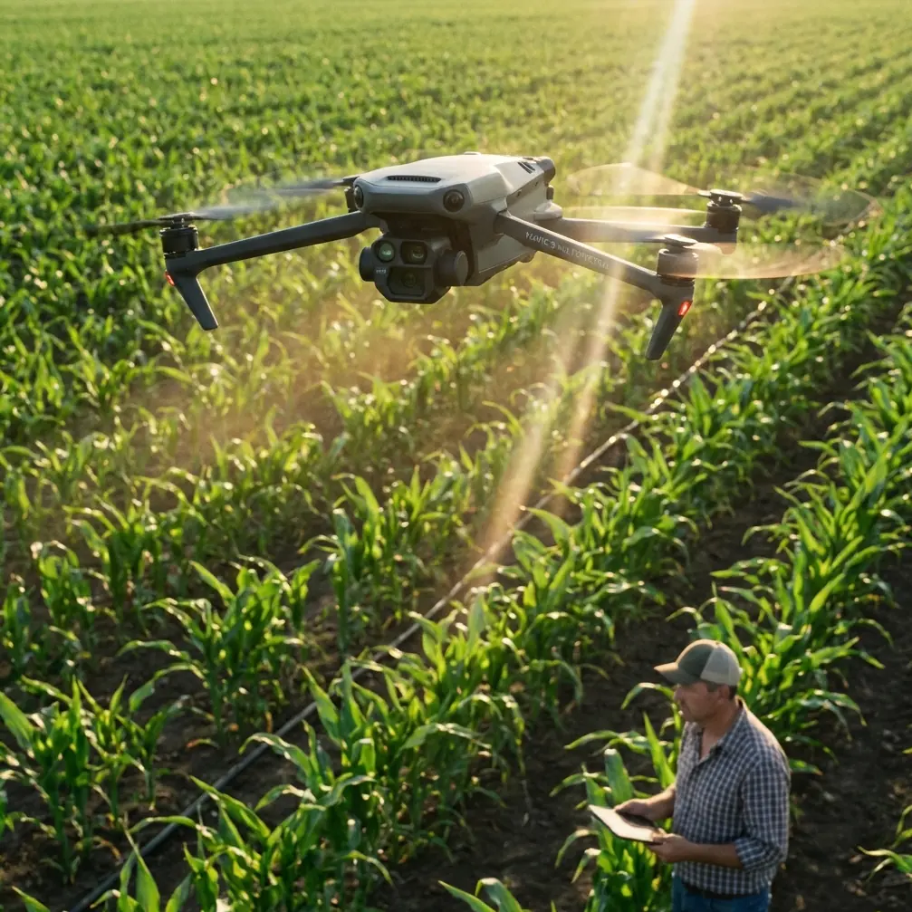
The technical challenge looked familiar enough: a long utility corridor, crosswinds pushing harder than the morning forecast suggested, and a vegetation-control program that could not afford drift into adjacent ground cover. The aircraft in question was a Mavic 3M, brought in to support corridor assessment and treatment planning around power lines where wind, terrain, and access constraints made conventional fieldwork slow and inconsistent.
What changed was not only the weather.
In 2026, China put the Ministry of Public Security’s “unmanned aircraft public security management platform” online nationwide through a WeChat mini program. For operators, that created a new reality. Drone oversight no longer sits only inside civil aviation registration. It now runs on two parallel tracks: public security filing and civil aviation registration, and both must be completed. For anyone using a Mavic 3M in real commercial work, that is not paperwork trivia. It directly affects whether the aircraft can be deployed legally, documented properly, and defended operationally when a project involves sensitive infrastructure, public visibility, or questions about flight legitimacy.
That dual-registration shift matters even more in utility spraying environments, especially on windy days, because these jobs draw scrutiny from multiple angles at once: airspace safety, public safety, pilot competence, and traceability of the aircraft itself.
The field day that exposed the difference between “airspace compliant” and “fully compliant”
The mission brief was straightforward on paper. Inspect a section of corridor, identify vegetation pressure near the line, map treatment zones, and support a targeted spraying workflow under windy conditions. The Mavic 3M was not being treated as a generic camera drone. Its value was in structured observation: repeatable route capture, geospatially stable imagery, and multispectral context that helped distinguish vegetation vigor rather than just surface color.
That distinction matters near power infrastructure. In these environments, crews are often balancing three competing risks:
- untreated regrowth near the line
- over-application in the wrong location
- drift caused by wind and rotor wash
The Mavic 3M helps most when it is used to tighten the decision loop before spraying starts. Multispectral capture can reveal vegetation variability that standard RGB imagery may understate, especially where visually similar cover responds differently to treatment. In corridor work, that can influence swath planning, nozzle calibration strategy, and whether treatment should proceed at all under the day’s conditions.
But before any of that, the aircraft itself now lives inside a stricter compliance framework.
Under the current Chinese system described in the source material, the Civil Aviation Administration’s UOM platform remains responsible for aviation safety and airspace management. It requires drone registration and a QR code attached to the aircraft. The Ministry of Public Security platform, by contrast, focuses on social public safety management. The practical consequence is simple: UOM registration alone is no longer enough. If the Mavic 3M is flying commercially, the operator needs to treat public security filing as an equally necessary preflight requirement.
For utility contractors, that has operational significance in two ways.
First, a corridor job near visible public infrastructure can trigger attention from landowners, site managers, or local authorities. A drone that is properly filed in both systems is easier to validate in the field. Second, fleet governance becomes more serious for organizations running multiple aircraft, replacement airframes, or modified platforms. The source notes that the public security platform covers the full range of civil UAV classes, from micro to large, and specifically includes self-built and modified aircraft. That broad coverage signals a regulatory intent to close gaps, not leave edge cases floating outside the system.
For a Mavic 3M operator, the lesson is obvious: compliance can no longer be handled casually as a one-platform exercise.
Wind changes everything, especially around spray drift
The day itself turned difficult by mid-morning. Gusts were rolling across the corridor at an angle rather than running cleanly down the line. That is exactly the kind of condition where bad spraying decisions happen. Teams often focus on whether the aircraft can physically fly. The more useful question is whether the treatment can be applied with control.
These are not the same thing.
A Mavic 3M is not a heavy dedicated spraying platform, so in this workflow its role centered on mapping, condition assessment, and decision support around treatment zones rather than brute-force application. That turned out to be an advantage. When the wind started distorting assumptions, the aircraft’s imaging pass made clear that the “spray everything in one sequence” plan would have been sloppy. The multispectral layer highlighted uneven vegetation stress along the corridor, with denser, healthier patches sitting next to areas that did not warrant the same treatment intensity.
That matters because spray drift is rarely just a weather problem. It is also a planning problem. If your swath width assumptions are built for calm conditions, and your nozzle calibration was set before gust patterns changed, then even a technically precise aircraft can support an imprecise operation.
In windy utility work, centimeter precision only helps if the treatment logic behind it is equally disciplined. RTK fix rate, route spacing, target segmentation, and buffer margins all need to work together. Too many operators talk about positioning precision as if it automatically solves application accuracy. It does not. It solves one layer of uncertainty. Wind introduces another.
On this corridor, the better approach was to break the line into smaller operational blocks, narrow the effective treatment width where crosswind exposure was worst, and revise timing so the team avoided the most unstable period of the day. That is not glamorous. It is what competence looks like.
Why a wildlife moment mattered more than people expected
The most revealing moment had nothing to do with mapping software or regulation.
As the aircraft tracked along a treeline break near one pole set, a large bird lifted unexpectedly from low cover and crossed obliquely beneath the route line before climbing. It happened fast. Not cinematic-fast. Real-fast—the kind of movement that punishes crews who have become too comfortable with repeat missions.
The Mavic 3M’s sensing and cautious route discipline helped the pilot avoid turning a routine pass into a preventable incident. That moment mattered for two reasons.
One, utility corridors are ecological edges. You are not working in a sterile environment. Birds, small mammals, and shifting vegetation all complicate operations, especially when wind already narrows the pilot’s margin. Two, it reinforced why public-safety-centered regulation is not abstract bureaucracy. The Ministry of Public Security platform exists because drone operations affect more than controlled airspace. They intersect with people, infrastructure, and unpredictable conditions on the ground.
The source material describes the new police-managed platform as emphasizing “person-certificate and machine-certificate integration” for stronger public security control. Translated into operational terms, that means the aircraft and operator are expected to be traceable as a unit. On a visible infrastructure job, with a wildlife near-miss and weather variability in play, that traceability is not hard to justify.
The hidden compliance problem with fleet rotation
Another issue surfaced after the mission review. The company had treated administrative records as a back-office function, separate from field execution. That used to be survivable when crews only thought in terms of civil aviation registration. It becomes much riskier in a dual-filing environment.
Commercial teams often rotate aircraft. One drone goes down for service, another substitutes in, payload configurations change, and field leaders assume the paperwork follows the project rather than the airframe. It does not. The source makes clear that the public security platform is an official real-name filing and safety management system. Combined with the UOM requirement to register and affix a QR code, this means every active aircraft in a commercial fleet should be treated as a compliance object in its own right.
For Mavic 3M operators supporting infrastructure vegetation programs, this has direct consequences:
- substitute aircraft cannot be treated casually
- records need to be current before deployment day
- visible identification and registration status should be field-check items, not office assumptions
This is especially true if the drone is used in a mixed workflow that includes mapping, corridor documentation, treatment planning, and post-treatment verification. The more functions the aircraft serves, the more likely it becomes part of a report chain, contractor handoff, or incident review.
What experienced operators should actually change
The strongest takeaway from this case is not “register your drone.” Serious operators already know registration matters. The more useful takeaway is that 2026 changed the structure of drone legitimacy in China. A Mavic 3M working around power lines in wind is now operating inside a system where aviation compliance and public-safety compliance run in parallel.
That should change how teams prepare.
Start with pre-mission governance. Confirm that the aircraft is covered in both the CAAC UOM system and the Ministry of Public Security’s platform. Do not assume one replaces the other; the source explicitly says both are required, and neither is optional if you want a complete compliance posture. Confirm the QR identification required for the UOM side is present and readable.
Then move to mission design. In windy corridors, avoid broad treatment assumptions. Use the Mavic 3M’s multispectral capability to separate areas that need intervention from areas that only look similar in RGB imagery. Revisit swath width planning against real wind behavior rather than the optimistic version from the schedule. Treat nozzle calibration as a live operational variable, not a one-time setup task.
Next, protect RTK discipline. Centimeter-level positioning is valuable in power-line environments, but only if fix stability is maintained and route logic respects gusting conditions. RTK is not a substitute for judgment. It is a precision layer that becomes meaningful when the rest of the workflow is equally controlled.
Finally, account for what the corridor actually is: public-facing infrastructure embedded in a living environment. That means bystanders may ask questions, wildlife may appear unexpectedly, and every flight should be defensible both technically and administratively.
If your team is revising SOPs for that kind of work and wants a second set of eyes on the compliance side, this WhatsApp channel for operational questions is one practical place to start.
The larger lesson for Mavic 3M users
The Mavic 3M remains a sharp tool when the mission is about informed intervention rather than blunt-force flying. In windy utility environments, its real value shows up before and after treatment: identifying where action is justified, documenting conditions with repeatability, and reducing the guesswork that often leads to over-application or drift exposure.
What the 2026 regulatory change adds is discipline around accountability. The new public security filing system did not replace civil aviation registration. It stacked on top of it. That creates more work, yes, but it also reflects the reality of how drones are actually used now. They are not hobby objects floating outside public systems. They are commercial machines operating near infrastructure, communities, and environmental variables that do not forgive lazy procedures.
On this corridor job, the wind forced better planning. The bird crossing forced better awareness. The dual-registration framework forced better administration. Put together, those three pressures produced a cleaner operation than the original plan would have.
That is the real best practice for a Mavic 3M in this kind of environment: not flying because the drone can, but deploying because the mission, the paperwork, and the conditions all align.
Ready for your own Mavic 3M? Contact our team for expert consultation.