Mavic 3M in Mountain Forestry: What Actually Changes When
Mavic 3M in Mountain Forestry: What Actually Changes When Precision Matters
META: A field-based case study on using Mavic 3M workflows in mountain forestry, with lessons on operator training, route discipline, multispectral decision-making, and precision execution.
Mountain forestry spraying looks simple on a map and unforgiving in real life.
Tree lines break the wind in one corridor and accelerate it in the next. Slopes distort depth perception. GNSS quality can feel solid on one ridge and fragile in the shadow of another. Add the need to limit spray drift while still covering enough swath width to keep the job economical, and the gap between a clean plan and a clean execution gets wide fast.
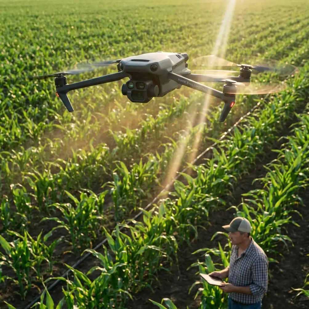
I have seen teams assume that a capable aircraft alone would close that gap. It does not. The aircraft matters, but the operating method matters more. That is exactly where the Mavic 3M becomes useful in mountain forestry—not as a generic drone success story, but as a tool that reduces uncertainty before the spraying platform ever lifts off.
The key lesson from recent aviation and training references is surprisingly clear: intelligent operations scale when autonomy is tied to disciplined human control. That sounds abstract until you apply it on a mountainside.
A recent civil aviation development in Xinjiang helps frame the point. On March 17, UISEE Technology and Xinjiang Airport Group signed a strategic cooperation agreement centered on combining autonomous driving technology with civil aviation scenarios. The scope is not small. Xinjiang Airport Group operates 27 civil transport airports and 2 general aviation airports. Operationally, that matters because large systems do not modernize through hardware alone. They modernize by connecting automation, route logic, and repeatable procedures across many varied sites.
Mountain spraying crews face the same problem at a smaller scale. Every valley behaves like a different airfield. Every block needs repeatable methods, not just a powerful platform. The Mavic 3M fits that need best when it is used as the intelligence layer for terrain-aware planning, crop or canopy interpretation, and route verification before chemical application begins.
The past problem: we were spraying blind in the hardest terrain
Several years ago, a forestry team I advised worked on disease-pressure treatment in steep, mixed-elevation woodland. Their biggest issue was not aircraft availability. It was decision quality.
They had broad treatment polygons, rough slope assumptions, and visual observations from the ground. What they lacked was current aerial intelligence at the level needed to adjust swath spacing, identify inconsistent canopy density, and isolate high-risk sections where drift could carry material downslope or across an adjacent stand.
That old workflow created three recurring failures:
- over-application in dense zones where pilots slowed unconsciously
- under-coverage along irregular edges and broken canopy openings
- poor timing decisions because the team could not see vegetation variability early enough
The Mavic 3M changed that by shifting the first phase of the job from estimation to measurement.
Its multispectral role is the center of that shift. In mountain forestry, multispectral data is not just a nice layer for reports. It helps separate visually similar areas that behave differently during treatment. A slope-facing section under stress may require a different priority than a sheltered patch with stronger vigor. If you know that before spraying, you can alter mission boundaries, sequence the work more intelligently, and reduce wasted passes in low-priority blocks.
That is where centimeter precision and RTK fix stability become practical rather than promotional terms. In forestry, small positional errors become large operational errors when terrain and canopy geometry are complicated. A strong RTK fix rate supports cleaner alignment between survey data, prescription thinking, and the eventual spray mission. On open agricultural plains, a minor discrepancy may be tolerable. In mountain forest corridors, it can push a line into the wrong gap or leave untreated slivers near edges that matter most.
Why training doctrine matters more than people think
One of the provided training references is for an educational DJI TT drone, not the Mavic 3M itself. At first glance, that may seem unrelated. It is not.
The manual notes that some smart flight modes require battery levels above 50%, and it describes structured behaviors such as a throw-launch sequence that must occur within 5 seconds, as well as a bounce mode operating roughly 50 to 120 centimeters above the takeoff surface. None of that is directly about forestry spraying. What matters is the operating philosophy underneath it: smart functions only help when the pilot understands conditions, thresholds, and timing.
This is highly relevant to Mavic 3M use in mountain forestry. Pilots who rely on automation without understanding constraints tend to make poor decisions exactly when terrain becomes complex. In my experience, the best Mavic 3M operators are not the ones who touch the sticks the least. They are the ones who understand when to trust automation, when to verify it, and when to re-fly a segment because the environment has changed.
The same educational text also discusses control mode preference and explains that pilot effectiveness often comes down to habit, familiarity, and repeated practice rather than ideology. Again, that translates directly. A forestry operator planning multispectral capture over mountain blocks needs control fluency that is boringly reliable. If basic aircraft handling still consumes mental bandwidth, there is less attention available for wind reading, terrain separation, overlap quality, or identifying problem sectors in real time.
The second training reference, a classic aerobatic instruction text first created in 1987, contributes an even more valuable principle: once a maneuver becomes standardized, the operator saves mental effort and can refine the task with greater precision. It also states that a straight horizontal line parallel to the runway is the foundation of aerobatic work.
Take that into the forest and the implication is obvious. Consistent route geometry is the foundation of good aerial data and good aerial application planning. No one is doing aerobatics in commercial forestry operations, nor should they. But the discipline behind the teaching is exactly right. Break each operation into component actions. Standardize them. Reduce cognitive clutter. Then performance improves.
That is how the Mavic 3M delivers real value. It supports a workflow where the difficult part of the job is organized before the spray aircraft enters the treatment block.
What the Mavic 3M is actually doing for a mountain spraying team
In this type of job, I do not treat the Mavic 3M as the machine that “does everything.” I treat it as the aircraft that reveals what the rest of the operation should do next.
A strong mountain forestry workflow usually looks like this:
- map the block with disciplined route planning
- collect multispectral and visual data with consistent overlap and stable positioning
- identify stress patterns, canopy density changes, and edge-risk zones
- redesign spray lines, swath width assumptions, and entry sequence around that reality
- execute the spray mission with better drift awareness and fewer surprises
That sequence sounds straightforward, but its value multiplies in mountains because the terrain punishes vague planning.
For example, nozzle calibration on the spraying platform is often discussed as a standalone maintenance task. It is not. Calibration only becomes meaningful in context. If the Mavic 3M survey shows abrupt changes in canopy density or slope exposure, then your expected deposition pattern may change along the route. That can influence flow assumptions, speed strategy, and even whether a single pass design is sensible for the whole block.
The same goes for swath width. On paper, operators like broad assumptions because they make planning easy. In a mountain forest, broad assumptions usually hide expensive mistakes. Multispectral and high-quality route data can show where canopy closure narrows the effective treatment corridor or where edge irregularity makes nominal swath width unrealistic. That insight helps reduce drift and overlap problems before product is loaded into the spray aircraft.
The hidden advantage: cleaner communication across teams
Large aviation systems increasingly aim for integrated air-ground operations. That was one of the notable implications of the Xinjiang agreement: the vision was not just automation in isolation, but an “air-land integrated” intelligent transport ecosystem. In forestry terms, the parallel is that the drone team, the ground crew, and the spray operators need to work from one operational picture.
The Mavic 3M is valuable here because it produces evidence that everyone can act on.
A field scout may suspect a ridge is too exposed in the afternoon. A pilot may feel the same after one pass. But when multispectral mapping and precise visual data support that judgment, rescheduling or redesigning the route becomes easier to justify. Teams stop arguing from intuition and start adjusting from shared data.
This improves conversion from planning to execution. Not sales conversion—operational conversion. Fewer aborted attempts. Fewer mid-mission improvisations. Better recordkeeping. Better post-job analysis.
If your crew is building or refining that workflow, I usually recommend comparing route logic, terrain segmentation, and payload strategy with a specialist rather than copying a flat-field template. For teams that want to discuss mountain forestry setup details, this field workflow contact is a sensible place to start.
Drift control starts long before the first droplet
Spray drift is often framed as a weather problem. Weather matters, but drift in mountain forestry is also a planning problem.
When a team uses Mavic 3M data well, they can identify the sections where topography is likely to channel air movement unpredictably. They can also isolate canopy openings and edge transitions where droplets are more likely to escape the intended target zone. This is where the aircraft’s value becomes very practical. Better reconnaissance leads to better choice of route direction, better timing windows, and more realistic expectations around buffer behavior.
An operator who knows the block only from satellite imagery is reacting. An operator who has current multispectral and visual mapping is anticipating.
That difference is not academic. It affects how confidently a team can fly near sensitive edges, how aggressively they set mission spacing, and whether they break one large block into several smaller treatment units to manage exposure.
Ruggedness still matters
Forestry environments are hard on equipment. Dust, moisture, uneven setup areas, and long travel days all add friction. That is where operators naturally begin to care about practical traits such as IP-rated protection and deployment reliability. An IPX6K-level expectation, in the mind of many professional users, represents the broader question: can the aircraft and its workflow tolerate real field abuse without constantly forcing compromises?
The answer with the Mavic 3M is not that it replaces purpose-built spraying platforms. It does something subtler and often more valuable. It lets those heavier platforms operate with fewer assumptions and better intelligence.
That means fewer redundant passes. Better boundary confidence. More disciplined use of spray windows. More accurate records for follow-up treatment decisions.
My professional takeaway
The most useful way to think about the Mavic 3M in mountain forestry is this: it is the aircraft that makes the spraying aircraft smarter.
That sounds simple, but it solves a real problem. Mountain jobs fail when planning quality lags behind aircraft capability. The Mavic 3M closes that gap by combining multispectral insight, precise route execution, and data that can be shared across the whole team.
The reference materials behind this view point in the same direction. One shows how large civil aviation systems are moving toward integrated intelligent operations across many airports and sites. Another shows that smart features only work when pilots understand thresholds and operating discipline. The third reminds us that skill becomes scalable when complex actions are broken down, standardized, and practiced until they no longer consume unnecessary mental energy.
Put those ideas together and the case for the Mavic 3M in mountain forestry becomes stronger than any spec sheet.
It is not there to impress anyone on takeoff. It is there to reduce doubt before treatment begins, tighten the link between scouting and execution, and make difficult terrain behave a little more like a controlled system.
That is why it earns its place in a serious mountain spraying workflow.
Ready for your own Mavic 3M? Contact our team for expert consultation.