Mavic 3M in Urban Field Spraying: What a 443
Mavic 3M in Urban Field Spraying: What a 443-Team Drone Event in Chengdu Reveals About Precision Work Near People, Parks, and Wildlife
META: A practical expert article on using the Mavic 3M around urban-edge fields, with lessons from Chengdu’s 443-team drone competition, multispectral planning, RTK precision, spray drift control, and safer low-altitude operations.
Urban field spraying sounds simple until you stand at the edge of the job.
One side is a crop block or managed green strip. The other is a road, a school boundary, a warehouse roofline, a bike path, or a landscaped park where people expect zero overspray and very little noise. The technical challenge is not just covering plants. It is making clean agronomic decisions in compressed airspace, with tighter margins for error than broadacre work.
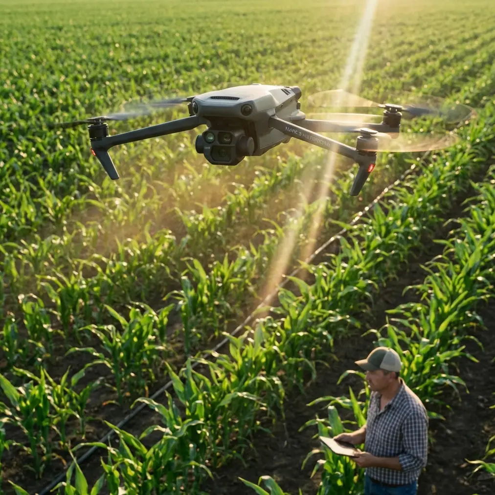
That is why the Mavic 3M deserves a more specific conversation than the usual product summary.
The most useful clue comes from an unexpected place: a major drone event in Chengdu. On April 11, the World Drone Sports Games opened at Xinchuan Heart Robot Park in Chengdu High-tech Zone, with 443 teams competing from primary and secondary schools, universities, and enterprises from China and abroad. At first glance, a sports event has little to do with spraying. In practice, it says a lot about where low-altitude drone operations are heading.
When hundreds of teams gather in a high-tech urban district, around a robot park rather than an isolated rural test site, the signal is clear. Drone work is moving into denser, more public, more mixed-use environments. That matters for anyone trying to use a platform like the Mavic 3M to support urban or peri-urban spraying workflows. The real question is no longer whether drones can operate low and precisely. It is whether the operator can maintain agronomic quality while respecting the complexity of an urban-edge environment.
The urban spraying problem is not just drift. It is decision quality.
Most discussions about spraying near cities focus on spray drift. Fair enough. Drift can damage non-target plants, contaminate adjacent spaces, and create immediate complaints. But drift is only one layer of the problem.
The deeper issue is decision quality before liquid ever leaves a nozzle.
If your map is weak, your treatment block is too broad. If your boundary is loose, your exclusion zone is too narrow. If your positional confidence is unstable, your swath overlaps where it should not and misses where it should not. Urban field spraying punishes all of those mistakes because there is often no forgiving buffer zone.
This is where the Mavic 3M’s value is often misunderstood. It is not a sprayer in the traditional sense. Its strength is that it helps the operator see crop variability and define intervention zones with much more discipline before spraying equipment is deployed. In urban settings, that planning layer can be more important than raw application speed.
The “M” in Mavic 3M matters because multispectral data changes how you frame the task. Instead of treating an entire field edge as one uniform target, you can identify where vegetation stress is emerging, where vigor is inconsistent, and where treatment intensity may need to be adjusted. In other words, the aircraft can help you shrink the treated area to what actually needs attention.
That directly reduces drift exposure. The safest spray is often the one you do not make.
Why the Chengdu event matters more than it seems
A competition with 443 teams is not just a headline number. It reflects scale, operational density, and a wider social acceptance of drones in visible public settings. The teams came from schools, universities, and enterprises, including international participants. That mix matters.
Schools represent the training pipeline. Universities represent research and method development. Enterprises represent field deployment. When all three are present in one event at an urban high-tech venue, it suggests that low-altitude operations are becoming a normal part of the technical landscape rather than a niche specialty.
For urban agricultural spraying support, that has two practical implications.
First, expectations are rising. A contractor working near homes, campuses, logistics parks, or municipal greenbelts will increasingly be judged not just on whether the crop got treated, but on how controlled, traceable, and professional the operation was.
Second, the skills bar is moving upward. The future operator is not only a pilot. They need to be comfortable with multispectral interpretation, RTK-backed mission planning, nozzle calibration logic, and environmental assessment. The Mavic 3M fits that shift because it sits upstream of spraying as a measurement and planning tool, not merely an airborne camera.
A problem-solution workflow for urban-edge spraying with Mavic 3M
Let’s put this in a real scenario.
Imagine a compact vegetable block on the edge of an urban district. A public walking trail runs along one side. A drainage channel borders another. A landscaped pond lies just beyond the corner. During a pre-treatment survey, a small egret lifts from the reeds near the waterline as the drone approaches, then veers away while the aircraft’s sensing and route control allow the pilot to keep a disciplined stand-off instead of forcing a low, abrupt correction over the crop.
That moment may seem minor. It is not.
Wildlife encounters are common in urban-edge agriculture because fragmented habitat and managed planting often sit close together. A drone platform used in this environment needs enough situational awareness to support calm piloting rather than rushed maneuvering. Operationally, that matters because sudden corrections near a field boundary can spoil data capture consistency, distort overlap, and later compromise the precision of treatment zone definition. Better sensing does not merely protect the aircraft. It protects the quality of the agronomic map.
So how should a thoughtful operator use the Mavic 3M here?
1. Start with a boundary-first survey mindset
In open farmland, operators sometimes think from the center outward. In urban environments, the reverse is smarter. Define edges, exclusion strips, obstacles, and sensitive adjacencies first.
The Mavic 3M is useful because multispectral and standard visual data together help separate operational crop area from features that should not be involved in the spray decision at all: drainage ditches, ornamental vegetation, pathways, utility margins, and wet patches. This matters because spray drift risk increases when mission geometry is vague. Cleaner polygons mean cleaner treatment plans.
2. Use multispectral findings to reduce total sprayed area
This is the practical bridge between sensing and spraying. If the survey shows stress clustered in only part of a block, there is no reason to plan the application as if the whole area is uniform.
Multispectral mapping supports selective treatment logic. In urban or suburban fields, every meter of unnecessary application expands your exposure to drift, public concern, and wasted product. A more selective intervention can tighten the swath strategy and reduce the number of passes near sensitive edges.
This is one of the biggest operational significances of the Mavic 3M. It converts a blanket-treatment mindset into a zone-treatment mindset.
3. Treat RTK fix rate as a spray risk variable, not a technical footnote
People often discuss centimeter precision as if it is a branding phrase. In urban spraying support, it is a risk-control tool.
Buildings, reflective surfaces, roadside infrastructure, and tree lines can all complicate positioning quality. If the RTK fix rate is unstable, route fidelity can degrade just enough to affect overlap and edge accuracy. In broadacre conditions, small deviations may be tolerable. Near a sidewalk, school perimeter, or ornamental planting strip, they are not.
Centimeter-level positioning matters because it helps you preserve repeatable path geometry. That leads to more reliable scouting outputs, more trustworthy treatment maps, and cleaner handoff to the spraying platform. The significance is operationally simple: tighter positioning upstream usually means fewer surprises downstream.
4. Pair map quality with nozzle calibration discipline
Even the best map cannot save a poor application setup.
If the Mavic 3M identifies a narrow target zone along an urban field margin, the spraying system that follows must be calibrated to match that precision. Nozzle calibration, droplet profile, pressure settings, and effective swath width all have to reflect the actual target geometry and environmental conditions. Otherwise, the precision of the survey is lost during application.
This is where many operations underperform. They invest in high-quality sensing but keep rough assumptions in the spray setup. In urban conditions, that mismatch is expensive. If your map defines a treatment strip three meters inside a sensitive edge, but your real deposition pattern exceeds the expected swath width under local wind conditions, you have turned a precise plan into an imprecise outcome.
The Mavic 3M does not replace calibration work. It makes the need for it impossible to ignore.
Spray drift in cities is often a planning failure before it becomes a weather problem
Wind always matters. But in urban-edge fields, drift is often made worse by planning shortcuts.
A rushed operator may choose uniform passes despite visible variability. They may ignore microclimate effects near walls or roads. They may overestimate the usefulness of a nominal swath width without checking how edge turbulence changes deposition. They may also fail to respect how quickly conditions shift around water, pavement, and landscaped features.
The smarter approach is to use the Mavic 3M as the front end of a drift-reduction system:
- map variability before application,
- minimize treated area,
- build exclusion buffers based on real site geometry,
- verify RTK stability in the actual environment,
- calibrate nozzles to the target and not the habit of the operator,
- reassess passes near sensitive boundaries.
That sequence matters more in urban settings than sheer flight efficiency.
Why training culture now matters as much as hardware
The Chengdu event points to something the drone industry sometimes glosses over: operational maturity comes from culture, not just equipment. An event hosted in a high-tech district and drawing 443 teams from schools, universities, and enterprises shows a live ecosystem of training, experimentation, and applied skill-building.
For the Mavic 3M user, that is a useful model.
The best urban spraying support teams operate like interdisciplinary units. They understand plant stress signals, positional data quality, low-altitude flight discipline, and public-facing professionalism. They are not just “good pilots.” They are good decision-makers under spatial constraints.
That is especially relevant for urban agriculture, municipal green management, research plots, campus farms, and peri-urban horticulture. These are exactly the places where low-altitude drones will be most visible and most scrutinized.
Durability and field reality still count
Precision talk should not distract from the ordinary demands of field work. Urban-edge operations often involve repeated redeployment, damp grass, irrigation mist, dust from service roads, and stop-start workflows around access limits. Features such as an IPX6K-class weather-resistant design are not glamorous, but they matter because the real job is rarely performed in ideal laboratory conditions.
A drone used to generate pre-spray maps has to be ready for field moisture, quick turnarounds, and inconsistent staging areas. Reliability affects data continuity. Data continuity affects planning. Planning affects drift control and treatment efficiency.
That chain is easy to underestimate until a partially completed survey forces you to improvise around missing sections.
The real role of the Mavic 3M in urban spraying
The Mavic 3M should not be viewed as a simple add-on to a spraying workflow. In urban and suburban environments, it is better understood as a precision planning instrument that helps answer three critical questions before application begins:
- Where is treatment actually needed?
- How tightly can that treatment zone be bounded?
- Can the site support repeatable, centimeter-level mission accuracy without introducing edge risk?
If you can answer those questions well, the actual spray operation becomes smaller, cleaner, and easier to defend technically.
That is the difference between using drone data because it looks modern and using it because it materially lowers operational risk.
If your team is working through that transition and wants to discuss workflow design, RTK planning, or multispectral use around sensitive urban field edges, you can message a specialist here.
The larger lesson from Chengdu is not about sport alone. It is about normalization. Drones are now operating in places where the public can see them, institutions can train with them, and enterprises can apply them at scale. When an event can gather 443 teams from such a broad mix of participants in a city high-tech zone, it signals that low-altitude aviation is no longer waiting for relevance. It is already part of the operating environment.
For Mavic 3M users involved in urban field spraying, that means expectations will only tighten. Precision will matter more. Traceability will matter more. Calm execution around people, infrastructure, and wildlife will matter more.
And that is exactly where a well-used multispectral platform earns its place.
Ready for your own Mavic 3M? Contact our team for expert consultation.