Mavic 3M on Mountain Construction Sites: A Field Case Study
Mavic 3M on Mountain Construction Sites: A Field Case Study in Precision, Drift Control, and Smarter Spray Planning
META: A practical Mavic 3M case study for mountain construction spraying, covering multispectral planning, RTK precision, drift control, nozzle calibration, battery management, and why local UAV propulsion innovation matters.
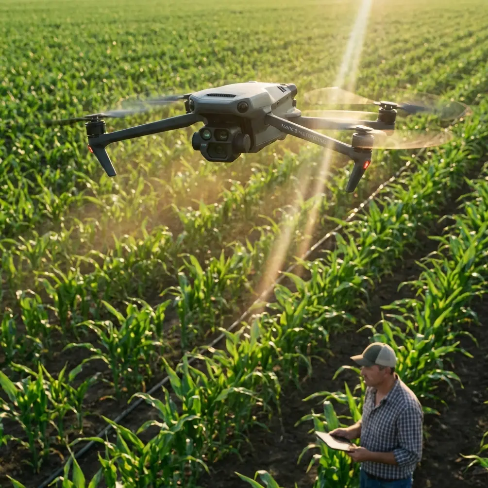
Mountain construction sites punish sloppy drone workflows.
You deal with broken terrain, fast-changing wind, narrow access roads, dust, reflective surfaces, and crews that want the job done without repeated passes. In that setting, the Mavic 3M earns attention for a reason: it is not just a camera drone with multispectral capability, but a planning instrument that can reduce guesswork before a spray team ever loads a tank.
This matters even more when the operation involves spraying on mountain projects. Whether the task is vegetation suppression around slope stabilization works, site rehabilitation monitoring, drainage corridor treatment, or identifying uneven ground conditions before targeted application, the cost of bad decisions shows up quickly. Drift reaches the wrong zone. Coverage becomes inconsistent. Batteries drain at the wrong moment. The “easy” line on the map turns into three separate altitude problems once you are in the air.
I have seen teams approach these jobs as if the spray aircraft alone is the whole solution. It is not. The better model is a two-layer workflow: the Mavic 3M for intelligence, then the application platform for execution. On mountain construction sites, that separation is often what keeps a spray program accurate and repeatable.
There is another reason this subject feels timely. A recent development out of Yunnan highlighted a locally developed UAV rotary engine, with Yunnan Mechanical and Electrical Vocational Technical College stating that its school-enterprise consortium has mastered the core technology and industrialized it. The institution described itself as the first in Yunnan and only the second in China to achieve that level of industrialization around UAV rotary engine technology. That is not a side story. It signals something larger: the drone industry is maturing beyond airframes and payloads into propulsion, manufacturing depth, and talent pipelines. The same report noted that the school plans to deepen industry-education integration and co-build projects with enterprises. For operators in difficult environments like mountain construction, that shift matters because reliability is never just about the aircraft in your hands. It depends on the broader ecosystem behind parts, training, maintenance knowledge, and application-specific engineering.
The real role of the Mavic 3M in a mountain spraying workflow
Let’s be direct. The Mavic 3M is not the spraying platform for a construction-scale liquid application job. Its value is upstream.
On mountain sites, the aircraft’s multispectral capability helps you map variability that standard RGB imagery can miss. That sounds abstract until you are standing on a cut slope with patchy regrowth, wet and dry transitions, different soil exposure levels, and runoff channels that create micro-zones. What looks uniform from the ground often is not. Multispectral data gives the site manager and spray operator a way to separate areas that need treatment from areas that only look problematic under harsh midday light.
Operationally, that changes three things.
First, it tightens swath planning. If you know where treatment is actually required, your effective swath width can be adjusted to the site condition instead of forcing one blanket pattern across the entire mountain face.
Second, it improves drift management. Spray drift is partly a weather problem, but it is also a planning problem. The more precisely you define treatment zones, the less temptation there is to overfly margins and “feather” coverage into uncertain areas.
Third, it reduces wasted battery cycles. Every unnecessary pass on a mountain site consumes energy you may need later when climbing, repositioning, or waiting for a safer wind window.
That is where centimeter precision and RTK Fix rate start to matter. If your map alignment is weak, your application boundaries drift from the real surface. On steep grades, a small positioning error can become a practical miss. A stable RTK workflow helps the Mavic 3M produce data that matches the terrain closely enough to guide a spray team with confidence instead of approximation.
A field case: slope treatment above an access road
On one project I advised, the challenge was a mountain construction corridor with exposed slopes above a temporary haul road. The site needed selective treatment in bands, not broad application. There were three constraints from the start:
- Wind accelerated unexpectedly along the cut line.
- The slope angle changed fast over short distances.
- Dust and water runoff had created visually confusing surface patterns.
A standard visual survey would have produced a rough treatment sketch and probably a larger-than-needed spray footprint. Instead, the Mavic 3M was flown first to generate a more disciplined site picture.
The multispectral layer helped separate active vegetation zones from sparse surface clutter. That may sound like a small distinction, but it prevented the team from targeting broad dusty areas that looked “green enough” from the road. Once those areas were excluded, the spray plan became narrower and more segmented.
This is where many teams make a mistake. They think segmentation slows the job down. In mountain work, the opposite is often true. A segmented plan aligned to real site conditions gives the spray aircraft cleaner entry and exit lines. It also lets the operator pause when crosswinds spike without compromising the entire pattern.
With good RTK alignment, we could hand over treatment boundaries that were practical, not theoretical. The application team then calibrated nozzle output to match the actual target density instead of using a generic rate across the whole face.
That one decision—using site-specific boundaries plus nozzle calibration—did more to control drift than any argument about pilot skill. Pilot skill matters, obviously. But if the liquid rate and droplet behavior are wrong for the target, even a strong pilot is forced into correction mode.
Why nozzle calibration matters more on steep terrain
Nozzle calibration is often treated like a preflight checklist item. On mountain construction jobs, it deserves more respect than that.
A slope changes your relative distance to the target as the aircraft moves, especially when the terrain profile is uneven. Add gusty conditions and you can end up with variable deposition across the same planned lane. If the nozzles are not calibrated to the real application profile, coverage can look acceptable in the logbook and still be poor on the ground.
The Mavic 3M helps before the first droplet leaves the tank because it gives the spray team a better map of where density shifts are likely. That means calibration is no longer based only on product label assumptions or a broad site average. It is informed by actual site variability.
For example, if a segment of the slope shows denser growth in one band and sparse cover in another, the team can rethink lane spacing and expected swath width instead of forcing one uniform pass structure. This is where “centimeter precision” stops being a buzzword and becomes operational. Precision is not simply about where the drone is. It is about whether the decision made from the map translates into the right liquid where it belongs.
Battery management: the field tip crews actually remember
The battery lesson that sticks with most mountain teams is not glamorous: do not chase the last few percent on a hillside mission.
In flat farmland, operators sometimes get away with stretching a pack to finish a pass. In mountain construction, that habit creates bad choices. You may need reserve power for a climb, a wind shift, an alternate landing point, or a go-around because a vehicle enters the work area.
My field rule is simple: rotate batteries earlier than you think you need to, and stage them according to terrain demand, not just charge percentage. A pack that looks fine on paper can sag faster after repeated high-load climbs and hover corrections near a cut slope. I prefer crews to assign the freshest batteries to the most altitude-demanding segments and use lesser-demand segments for packs later in the cycle.
For the Mavic 3M survey portion, that discipline is equally useful. If you fly the mapping mission with a battery plan built around safe reserve margins, your data quality usually improves because the pilot is not rushing the final legs of the route. Rushed mapping shows up later as weak overlap, compromised edge coverage, or unnecessary reflying.
On dusty mountain projects, I also advise letting batteries cool before rapid turnaround. Heat compounds enough other variables in these environments. There is no reason to add avoidable battery stress.
Weatherproofing, dust, and why ruggedness still matters even in a planning aircraft
Mountain construction sites are dirty. Fine dust, light rain, muddy staging areas, concrete residue, and abrupt temperature changes all work against electronics. That is why operators often pay attention to ruggedness standards such as IPX6K when comparing equipment in the broader workflow, especially if the spray platform itself must tolerate washdown and harsh site conditions.
Even when the Mavic 3M is serving in the survey and planning role rather than direct application, it benefits from the same mindset: protect sensors, inspect air intakes, keep landing zones clean, and do not normalize contamination just because the aircraft still powers on. On these sites, “good enough” maintenance habits eventually become data quality problems.
A clean lens and stable sensor package are not luxuries when you are relying on multispectral outputs to define treatment zones. If the planning layer is compromised, every downstream decision inherits that weakness.
What the Yunnan rotary engine story tells us about operations on difficult sites
The Yunnan news is easy to read as a local manufacturing milestone and move on. That would miss the larger point.
When a school-enterprise consortium says it has mastered the core technology of a UAV rotary engine and reached industrialization—while identifying itself as the first in Yunnan and the second nationally to do so—it tells us the industry is building capability at a deeper level. Propulsion knowledge, production capacity, and applied training are becoming more distributed.
For commercial operators, especially those working in mountains, that has practical significance.
A stronger domestic or regional UAV ecosystem can improve service resilience. It can widen the talent pool. It can produce closer feedback loops between operators, educators, and manufacturers. And because the same announcement stressed deeper industry-education integration and joint projects with enterprises, it suggests future drone programs may be built with field realities in mind rather than only lab assumptions.
That matters to anyone running planning and spray operations in tough terrain. Reliable work does not come only from buying a reputable platform. It comes from access to trained technicians, relevant R&D, and an industry that understands how aircraft are used in the real world.
The Mavic 3M sits inside that bigger picture. It represents one side of UAV maturity: advanced sensing in a compact airframe. The Yunnan engine development points to another side: propulsion and industrial depth. Together, they reflect an industry moving toward stronger specialization. For mountain construction workflows, that is good news.
A practical workflow for Mavic 3M-led spray planning
If I were setting up a repeatable process for a reader working on mountain construction spraying, it would look like this:
- Fly the Mavic 3M first, not as a formality but as the intelligence layer.
- Use multispectral outputs to separate actual treatment zones from visually misleading surfaces.
- Verify RTK Fix rate and geospatial consistency before building spray boundaries.
- Segment the site according to terrain breaks, wind exposure, and target density.
- Calibrate nozzles to those segments, not to a site-wide average.
- Set conservative battery rotation rules for both mapping and spray operations.
- Reassess swath width on the steepest or most wind-prone sections instead of forcing one pattern everywhere.
- Build drift control into the plan at the mapping stage, not only at the moment of application.
That workflow is not flashy. It is what keeps mountain jobs under control.
The hidden advantage: fewer arguments on site
One underrated benefit of using the Mavic 3M properly is that it reduces friction between teams.
Construction supervisors, environmental managers, drone pilots, and spray crews often look at the same slope and see different problems. Multispectral mapping with centimeter-level positioning gives them a common reference. That does not eliminate judgment calls, but it shortens the debate over where treatment is needed and where it is not.
On a busy site, that saves more than time. It lowers the chance of over-application, missed patches, and unnecessary rework. For teams coordinating under narrow weather windows, those gains are substantial.
If you are trying to design a mountain-site workflow around the Mavic 3M and want a practical discussion rather than a product pitch, you can message here for field-oriented advice.
Final take
The best way to use the Mavic 3M on mountain construction spraying jobs is to stop thinking of it as the whole operation. Its real strength is turning messy terrain into actionable treatment logic. Multispectral insight helps define where to spray. RTK-backed precision helps place those boundaries accurately. Nozzle calibration and swath adjustments translate that intelligence into cleaner application. Early battery rotation keeps crews out of trouble when the hillside demands more power than the percentage meter suggests.
And the broader UAV market is moving in a direction that supports this kind of professionalism. The Yunnan rotary engine milestone, along with the emphasis on industry-education collaboration, points to an ecosystem becoming more capable from the inside out. For commercial operators, that is not abstract industry news. It is part of the foundation that makes dependable field work possible.
Ready for your own Mavic 3M? Contact our team for expert consultation.