Mavic 3M for Wildlife Scouting in Wind: Guide
Mavic 3M for Wildlife Scouting in Wind: Guide
META: Learn how to scout wildlife with the DJI Mavic 3M in windy conditions. Expert tips on multispectral imaging, pre-flight prep, and flight stability.
By Marcus Rodriguez | Drone Consultant & Wildlife Survey Specialist
TL;DR
- Pre-flight sensor cleaning is non-negotiable—debris on the multispectral lens array compromises both image accuracy and obstacle avoidance safety in gusty conditions.
- The Mavic 3M's multispectral imaging system detects wildlife signatures that RGB cameras miss, even through partial canopy cover.
- Wind speeds up to 12 m/s are manageable with proper flight planning, but technique adjustments are essential beyond 8 m/s.
- Combining RTK Fix rate optimization with disciplined waypoint missions dramatically improves data consistency across repeat surveys.
Why Pre-Flight Cleaning Is Your First Safety Protocol
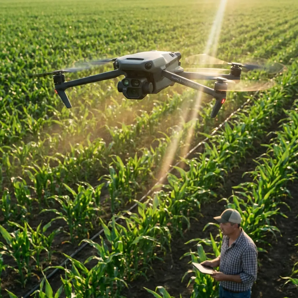
Wildlife scouting rarely happens in sterile environments. You're launching from dusty ridgelines, muddy wetland edges, and sandy coastal flats. Before you even power on the Mavic 3M, the single most overlooked step determines whether your entire mission succeeds or fails: cleaning the sensor array and obstacle avoidance sensors.
Here's why this matters more than most pilots realize. The Mavic 3M houses four multispectral sensors (Green, Red, Red Edge, and Near-Infrared) alongside a 20MP RGB camera. A single smudge or dust particle on any one of those lenses introduces radiometric error across your entire dataset. When you're trying to distinguish a deer bedded down in tall grass from the surrounding vegetation using NDVI signatures, that error isn't just annoying—it's mission-ending.
Equally critical: the omnidirectional obstacle avoidance system. Mud splatter or condensation on forward or downward vision sensors causes erratic braking behavior mid-flight. In windy conditions where the aircraft is already compensating aggressively for gusts, a false obstacle detection event can send your drone into an uncontrolled altitude change—directly toward terrain or tree canopy.
Pre-flight cleaning checklist:
- Use a microfiber lens cloth (not your shirt) on all six multispectral/RGB lenses
- Inspect and clean all eight obstacle avoidance sensors (forward, backward, lateral, upward, and downward)
- Check propeller surfaces for nicks, mud, or insect debris that affect aerodynamic balance
- Wipe the IMU ventilation area to prevent thermal regulation issues during sustained hover
- Verify the IPX6K-rated housing seals are free from grit that could compromise moisture resistance
Expert Insight: I carry a compressed air canister specifically for the multispectral lens array. In field conditions, wiping alone can grind fine particulates across coated glass. A quick blast of air before the microfiber pass extends lens coating life by an estimated 3–5x across a survey season.
Understanding the Mavic 3M's Multispectral Advantage for Wildlife Detection
Standard RGB drones capture what the human eye sees. The Mavic 3M captures what the human eye cannot. This distinction transforms wildlife scouting from a "fly and squint" exercise into a data-driven science.
The four discrete spectral bands allow you to generate vegetation indices like NDVI, GNDVI, and LCI in real time. Why does this matter for wildlife? Because animals interact with vegetation in measurable ways:
- Bedding sites compress vegetation, altering reflectance patterns visible in Red Edge (860 nm) data
- Game trails create linear disturbances in canopy density detectable through Near-Infrared contrast
- Thermal stress zones near water sources show distinct Green (560 nm) and Red (650 nm) signatures where animals congregate
- Grazing pressure is quantifiable through chlorophyll absorption differences captured in the Red band
The Mavic 3M's swath width varies with altitude, but for wildlife scouting, a flight altitude of 80–120 meters AGL typically balances spatial resolution with area coverage. At 100 meters, each multispectral pixel covers approximately 5.73 cm/pixel—sufficient to detect medium-to-large mammals through canopy gaps.
How to Fly Wildlife Surveys in Windy Conditions
Wind is the variable that separates casual drone pilots from effective wildlife scouts. The Mavic 3M handles wind well, but physics doesn't care about marketing specs. Here's a structured approach.
Step 1: Assess Wind Before You Launch
Use a handheld anemometer at launch altitude, not ground level. Wind at 10 meters AGL can be 30–50% stronger than at ground level due to reduced surface friction. The Mavic 3M's maximum wind resistance is rated at 12 m/s, but optimal multispectral data collection demands stability well below that ceiling.
Wind speed decision matrix:
| Wind Speed (m/s) | Condition | Recommended Action |
|---|---|---|
| 0–5 | Ideal | Standard survey parameters; full multispectral capture |
| 5–8 | Moderate | Reduce altitude to 80m; increase overlap to 80/75 (front/side) |
| 8–10 | Challenging | Switch to crosswind flight paths; reduce speed to 4 m/s; increase exposure compensation |
| 10–12 | Maximum | Abort multispectral mission; RGB-only recon at reduced altitude |
| 12+ | Unsafe | Do not fly |
Step 2: Optimize Flight Path Orientation
This is where most pilots fail in windy conditions. Flying into or with the wind produces the most stable imagery. Flying perpendicular to strong gusts causes lateral drift that the gimbal compensates for, but this compensation introduces subtle rolling-shutter artifacts in the multispectral bands.
Plan your waypoint missions so that primary survey lines run parallel to prevailing wind direction. The Mavic 3M's flight controller will manage groundspeed variation between headwind and tailwind legs automatically, but your overlap settings must account for the fastest groundspeed leg—which is always the tailwind pass.
Step 3: Dial In RTK for Centimeter Precision
Repeat wildlife surveys demand spatial consistency. If you're monitoring the same habitat corridor across weeks or months, each dataset must align precisely with previous captures. The Mavic 3M supports RTK positioning through the DJI D-RTK 2 base station, achieving centimeter precision in horizontal and vertical axes.
In windy conditions, RTK Fix rate becomes your quality indicator. A Fix rate below 95% means the aircraft is experiencing positioning uncertainty—often caused by satellite signal interruption when the drone banks aggressively in gusts.
To maintain high RTK Fix rate in wind:
- Ensure 14+ satellites are visible before launch
- Position the D-RTK 2 base station on elevated, unobstructed terrain
- Set waypoint mission speed to no more than 5 m/s to minimize aggressive attitude changes
- Monitor Fix rate in DJI Pilot 2; if it drops below 95%, pause the mission and reassess
Pro Tip: I always run a 3-minute static hover at survey altitude before beginning the actual mission. This lets the RTK solution stabilize and gives me a real-time assessment of how wind is affecting Fix rate at working altitude. If the Fix rate fluctuates during the hover, I know the mission data will be inconsistent—better to discover this before burning battery on a compromised survey.
Technical Comparison: Mavic 3M vs. Common Alternatives for Wildlife Scouting
| Feature | Mavic 3M | Phantom 4 Multispectral | Matrice 350 + MicaSense |
|---|---|---|---|
| Multispectral Bands | 4 + RGB | 5 + RGB | 5 + RGB (varies by payload) |
| Max Wind Resistance | 12 m/s | 10 m/s | 15 m/s |
| Flight Time | 43 min | 27 min | 55 min |
| Weight (Takeoff) | 920 g | 1487 g | ~7800 g (with payload) |
| RTK Support | Yes (D-RTK 2) | Yes (built-in) | Yes (built-in) |
| Obstacle Avoidance | Omnidirectional | None | Omnidirectional |
| Portability | Foldable, backpack-ready | Semi-portable | Vehicle-dependent |
| Weatherproofing | IPX6K rated housing | Minimal | IP45 |
| GSD at 100m | 5.73 cm/px (MS) | 5.2 cm/px | 5.4 cm/px (RedEdge-P) |
The Mavic 3M occupies a unique position for wildlife scouting specifically because of the portability-to-capability ratio. Reaching remote scouting locations on foot with a 920 g foldable platform versus hauling an enterprise-class system changes the fundamental logistics of wildlife survey work.
Leveraging Agricultural Features for Wildlife Habitat Analysis
Several Mavic 3M features designed for precision agriculture translate directly to wildlife scouting. Understanding these cross-applications unlocks capabilities most wildlife professionals overlook.
Nozzle calibration protocols from agricultural spraying missions teach disciplined pre-flight verification habits. The same rigor applied to checking spray drift patterns applies to verifying multispectral sensor calibration before wildlife surveys. Use a calibration reflectance panel before every flight—this is the wildlife survey equivalent of nozzle calibration.
The swath width planning tools in DJI Terra allow you to calculate exact coverage areas at your chosen altitude and overlap settings. For wildlife corridor surveys, set your swath width to ensure zero gaps between adjacent passes—even a 2-meter uncovered strip could contain the game trail or bedding site that defines your survey conclusions.
Common Mistakes to Avoid
Skipping the reflectance calibration panel: Without a calibration image taken under current lighting conditions, your multispectral indices are essentially uncalibrated. Vegetation signatures shift with sun angle, cloud cover, and atmospheric haze. Calibrate every flight, not every day.
Flying too fast in wind: Groundspeed above 6 m/s in winds exceeding 8 m/s creates motion blur in the narrowband multispectral sensors. The Red Edge and NIR bands are especially sensitive due to lower light throughput.
Ignoring battery temperature: Cold, windy conditions drain lithium-polymer batteries 20–30% faster than rated. The Mavic 3M's 43-minute flight time drops to approximately 30–34 minutes in cold, gusty environments. Plan missions for 75% of expected battery life, not 100%.
Setting uniform altitude across varied terrain: Wildlife habitats aren't flat. A fixed 100m AGL setting over rolling terrain means your GSD varies with elevation changes. Use the Mavic 3M's terrain follow mode or plan altitude adjustments manually for consistent centimeter precision in spatial resolution.
Launching without checking obstacle avoidance sensor cleanliness: As discussed in the pre-flight section, dirty sensors cause erratic flight behavior. In windy conditions, this compounds into genuinely dangerous situations near tree canopy.
Frequently Asked Questions
Can the Mavic 3M detect individual animals directly through multispectral imaging?
The Mavic 3M's multispectral sensors detect reflectance differences, not thermal signatures. You will not see an individual animal as a heat blob. Instead, you detect the environmental evidence of animal activity—compressed vegetation, disturbed soil, altered canopy density, and grazing impact zones. For direct animal detection, pair multispectral flights with thermal payload missions on a separate platform. The Mavic 3M excels at habitat characterization, not individual animal counting.
How does the IPX6K rating affect reliability during wildlife scouting in adverse weather?
The IPX6K rating means the Mavic 3M's housing resists high-pressure water jets from any direction. This protects internal components during sudden rain exposure or heavy mist common in coastal and wetland environments. It does not mean the drone is waterproof or submersible. Sustained rain will still degrade multispectral image quality through water droplets on lens surfaces, even if the electronics survive. Carry lens-clearing wipes and be prepared to land if precipitation begins mid-mission.
What's the ideal overlap setting for multispectral wildlife habitat mapping in windy conditions?
Set front overlap to 80% and side overlap to 75% as a baseline. In winds above 8 m/s, increase front overlap to 85% to compensate for groundspeed variation between headwind and tailwind passes. Higher overlap generates more data and longer processing times, but it ensures no gaps appear in your final orthomosaic—gaps that could hide critical habitat features. This overlap setting typically allows full coverage of a 40-hectare survey area on a single battery in moderate wind.
Ready for your own Mavic 3M? Contact our team for expert consultation.