Mavic 3M for Urban Vineyard Scouting: What Actually Matters
Mavic 3M for Urban Vineyard Scouting: What Actually Matters in Tight, Sensitive Airspace
META: A technical review of the DJI Mavic 3M for scouting urban vineyards, with practical insight on multispectral workflow, centimeter-level planning, arc-flight path discipline, and obstacle-awareness lessons from healthcare drone networks.
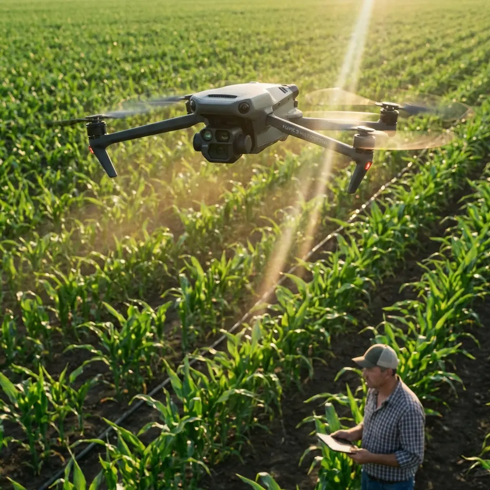
Urban vineyard scouting is an odd test for any drone. The rows are narrow. The light bounces off nearby buildings. Trees, utility lines, access roads, and reflective roofs all conspire to turn a routine crop survey into a precision exercise. When the aircraft in question is the Mavic 3M, the conversation should move beyond generic praise and into operational fit: how well it handles structured missions, how precisely it can repeat them, and how safely it can work in constrained environments where agricultural land meets dense infrastructure.
That is where the Mavic 3M becomes interesting.
This aircraft is often discussed through the lens of multispectral capability, and rightly so. In vineyard work, spectral data helps reveal uneven vigor, irrigation stress, disease pressure, and block-to-block variability before these issues become obvious from the ground. But in an urban vineyard, imaging alone is not the story. Flight geometry, repeatability, obstacle judgment, and route discipline carry equal weight. If your maps are not consistent, your agronomic interpretation drifts. If your flight path is sloppy around sensitive edges, the data may still be pretty, but it will be less useful for decisions such as canopy management, nozzle calibration planning, and spray drift mitigation.
Why urban vineyards expose weaknesses faster than open-field operations
A broad-acre field forgives small mistakes. A compact vineyard surrounded by roads and structures does not.
The Mavic 3M’s strongest role in this setting is not simply “capturing crop data.” It is generating repeatable evidence from a complex site without creating new problems. Urban vineyard managers care about centimeter precision because they are often comparing one row, one irrigation zone, or one problematic corner against previous flights. The value is in trend detection, not just image collection.
That makes RTK fix rate and route stability more than technical trivia. A strong positional solution supports cleaner temporal comparison. If a weak vigor patch appears in the same place over multiple missions, the team can act with confidence. If the geospatial alignment shifts from sortie to sortie, the interpretation becomes noisy. In vineyards near property boundaries, public walkways, or neighboring residential plots, that distinction matters.
This is also where the aircraft’s compact airframe works in its favor. Large agricultural platforms make sense for spraying or broad-area coverage, but scouting in urban-adjacent vineyards benefits from a smaller aircraft that can be launched quickly and routed precisely along constrained corridors. The Mavic 3M is a survey instrument first in this context, not a brute-force field machine.
Mission design is where good vineyard data begins
One of the most overlooked truths in drone agronomy is that the route determines the quality of the agronomic conclusion. The reference material on DJI educational flight logic, though built around a training platform, points to a principle that matters for Mavic 3M operators: curved flight paths can be defined through three spatial points, and the resulting arc has geometric constraints. Specifically, the circular arc determined by those points must have a radius between 50 and 1000 centimeters.
At first glance, that sounds unrelated to vineyard scouting. It is not.
What this teaches is that deliberate geometry produces smoother, more predictable aircraft motion than abrupt stick inputs or improvised corners. In the training example, the aircraft flies through points such as (100,100,0) and (100,-100,0) at 50 centimeters per second, then continues through mirrored points to complete a circular pattern while maintaining heading. Operationally, that kind of controlled, consistent movement matters in vineyards for two reasons.
First, it reduces image inconsistency at turns. Sharp transitions can distort overlap and create uneven data density at row ends. Second, it preserves safety margins near obstacles. In an urban vineyard, smooth arcs around buffer edges, trellis-end clearances, and access tracks are easier to predict than hand-flown corrections.
The Mavic 3M is not the DJI TT education drone, of course. But the underlying lesson transfers directly: plan flights as geometry, not as improvisation. When scouting vineyards bordered by walls, ornamental trees, and service lanes, mission smoothness translates into cleaner mosaics and fewer surprises.
Multispectral value is real, but only if tied to vineyard decisions
A multispectral payload can produce beautiful maps that never improve a vineyard. That is the harsh truth.
The Mavic 3M earns its keep when imagery is tied to action. In urban vineyard operations, the most practical outcomes tend to be selective inspection and treatment planning. A multispectral map may identify a section with reduced vigor or unusual canopy response. From there, the operator can ground-truth for irrigation issues, nutrition imbalance, compaction, or disease onset. That same map can refine where managers assess spray drift exposure, especially near edge rows adjacent to streets or neighboring properties.
This is where swath width and scouting altitude should be considered alongside agronomy. Wider coverage is efficient, but urban sites often reward a more conservative pattern with tighter overlap and stronger positional confidence. If the mission is intended to support nozzle calibration discussions or targeted canopy interventions later, consistency beats speed.
The Mavic 3M’s role is therefore diagnostic. It is a reconnaissance layer that helps teams decide where to walk, sample, inspect, and adjust. It can narrow uncertainty, but only when the survey is designed around a real vineyard question.
A wildlife encounter says more about drone suitability than a spec sheet
During one urban vineyard evaluation, the most revealing moment had nothing to do with reflectance indices. A grey heron lifted unexpectedly from an irrigation margin near the end of a row block, crossing laterally above the vine line just as the aircraft approached a turning segment.
That moment underscored a point many product pages never reach: a scouting drone in a live agricultural environment must cope with dynamic, imperfect reality. Birds, workers, vehicles, and changing wind near structures all shape mission risk. The right response is not aggression or speed. It is controlled navigation, conservative spacing, and reliable situational awareness.
This is where the broader autonomy discussion from the reference literature becomes useful. One source notes that optical flow offers only general guidance about obstacles and lacks the resolution needed for more sophisticated flight in cluttered environments. It also describes a stereo vision concept called “pushbroom stereo,” and cites processing benchmarks of 376x240 image pairs at 127 fps or 752x480 at 60 fps on FPGA-based systems.
Those numbers are not Mavic 3M specifications, but they illuminate an operational reality: low-resolution obstacle cues are not enough when the environment is busy. Urban vineyards are not forests, yet they present their own clutter profile: poles, netting, trunks, wires, pergola edges, and sudden wildlife movement. The practical takeaway for Mavic 3M operators is simple. Do not overestimate basic sensing in a congested agricultural site. Build flight plans that assume you need margin, visibility, and escape space.
The heron encounter ended uneventfully because the mission had been designed with smooth turning room, not because the site was forgiving. That distinction matters.
What healthcare drone networks can teach vineyard operators
One of the more interesting recent drone developments came from XPONENTIAL 2026 in Detroit, where CVS Health shared new details about an emerging drone-enabled network called CVS Air Response. The panel with CVS, SkyfireAI, and Thales emphasized healthcare logistics, emergency response, and disaster resilience.
At first this seems far removed from a Mavic 3M in a vineyard. It is not.
The operational significance lies in how serious drone networks are now being framed: not as gadgets, but as infrastructure. In healthcare logistics and emergency response, a drone mission must be repeatable, dependable, and integrated into a larger decision chain. Vineyard scouting is heading in the same direction, particularly in urban agriculture where time windows, access constraints, and public sensitivity are tighter.
For Mavic 3M users, this signals a maturation of expectations. The aircraft is no longer just a seasonal imaging tool. In a disciplined operation, it becomes part of a vineyard intelligence network: scheduled scouting, flagged anomalies, targeted field inspection, and documented responses. Disaster resilience also has a quiet parallel in viticulture. After extreme weather, flooding, smoke exposure, or heat events, rapid aerial assessment can help prioritize recovery work without sending teams blindly across the site.
Healthcare logistics also reinforces another point: mission reliability matters more than spectacle. Vineyard operators should think in terms of standard operating procedures, preplanned launch sites, clear data naming conventions, and repeatable route libraries. If you need help building a practical urban-vineyard workflow around the Mavic 3M, a direct planning conversation can save weeks of trial and error: message the operations desk here.
Precision scouting has downstream value for spraying decisions
The Mavic 3M is not a spraying drone, but its scouting output can sharpen spraying decisions in ways that are often underestimated.
Spray drift is a constant concern in urban-adjacent vineyards. Managers need to know where canopy density changes, where vine stress may alter uptake patterns, and which border rows justify extra caution. Multispectral scouting helps isolate those zones before a spray plan is finalized. That supports better timing and more selective field checks, which in turn inform nozzle calibration and application settings on the actual spray platform.
This matters because urban vineyards operate under social as well as agronomic pressure. A drift incident near residences, roads, or neighboring businesses can carry consequences beyond crop performance. By using Mavic 3M data to narrow treatment zones and verify canopy variability, operators can make more defensible decisions. The aircraft’s value, then, is partly preventive. It reduces the chance of acting on guesswork.
What to look for in a serious Mavic 3M vineyard workflow
The strongest Mavic 3M operations in urban vineyards usually share a few traits.
They prioritize repeatability over improvisation. Missions are flown on stable templates, with altitude, overlap, and path geometry held constant unless there is a clear reason to change them.
They treat centimeter precision as operational, not decorative. A good RTK fix rate supports cleaner historical comparison and more trustworthy row-level analysis.
They use multispectral results as a decision trigger, not a vanity map. If a map does not drive inspection, intervention, or monitoring, it is just colorful documentation.
They respect clutter. The lesson from obstacle-detection research is that coarse visual cues are not enough in complex environments. Pilots should assume that urban vineyards deserve conservative routing.
And they plan turns well. The training reference on arc flight may come from an educational context, but its core insight is practical: smooth, defined curves produce more reliable behavior than abrupt transitions. In a vineyard with obstacles and sensitive boundaries, that can be the difference between a clean mission and a compromised one.
Final assessment
For scouting vineyards in urban settings, the Mavic 3M is at its best when treated as a precision survey platform inside a disciplined workflow. Its multispectral strengths are obvious, but the real advantage appears when those sensors are matched with careful route geometry, consistent RTK-backed repeatability, and conservative operation around clutter and wildlife.
Two reference details stand out as especially relevant here. The first is the educational arc-flight logic that defines a curved path through three points with a radius constrained between 50 and 1000 centimeters; operationally, that reminds us that controlled geometry improves both data consistency and safety. The second is the obstacle-perception finding that optical flow offers only general guidance, while higher-resolution stereo approaches can support more sophisticated navigation; in practice, that means vineyard operators should never assume a dense urban-agricultural site is simple just because the crop rows look orderly from above.
The Mavic 3M can produce excellent vineyard intelligence. But the aircraft alone does not create that outcome. Mission discipline does.
Ready for your own Mavic 3M? Contact our team for expert consultation.