Mavic 3M Guide: Scouting Mountain Vineyards
Mavic 3M Guide: Scouting Mountain Vineyards
META: Discover how the DJI Mavic 3M multispectral drone transforms mountain vineyard scouting with centimeter precision, RTK positioning, and NDVI mapping for viticulture.
By Dr. Sarah Chen | Precision Agriculture Researcher & Remote Sensing Specialist
TL;DR
- The DJI Mavic 3M combines a 20MP RGB camera with four 5MP multispectral sensors on a compact airframe built for rugged mountain vineyard terrain.
- Proper antenna positioning and RTK Fix rate optimization are critical for achieving centimeter precision on steep, canopy-dense slopes.
- Multispectral data enables real-time NDVI, NDRE, and GNDVI index computation, catching vine stress weeks before visual symptoms appear.
- This technical review covers field-tested workflows, common pitfalls, and comparison benchmarks relevant to precision viticulture professionals.
Why Mountain Vineyards Demand Specialized Aerial Scouting
Mountain vineyards present a unique convergence of challenges that ground-based scouting simply cannot address efficiently. Steep gradients exceeding 30°, fragmented canopy coverage, variable sun exposure across aspects, and restricted vehicle access make traditional row-by-row walks both time-intensive and inconsistent.
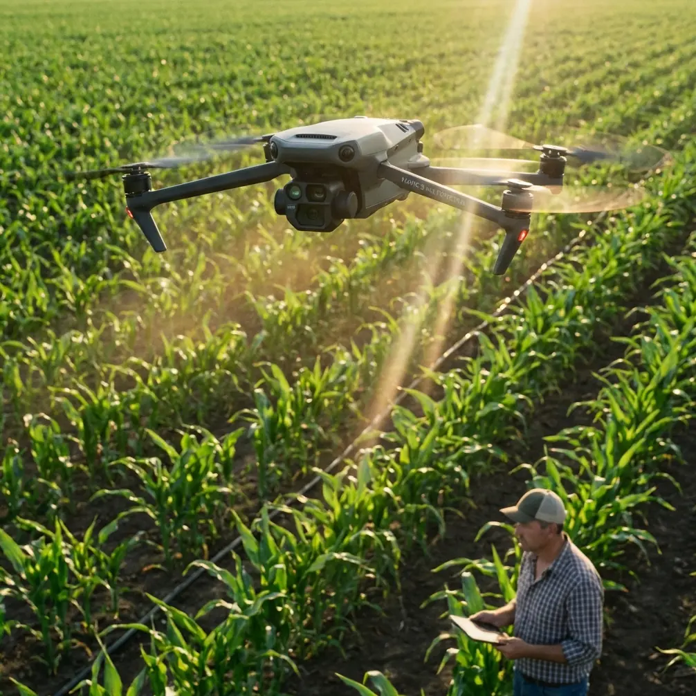
The DJI Mavic 3M was engineered for exactly this operational envelope. Weighing just 951 g with a compact foldable frame, it deploys in under three minutes on narrow terrace edges where larger platforms cannot safely launch. But raw portability means nothing without data quality—and that is where this drone's integrated multispectral imaging system earns its place in the precision viticulture toolkit.
This review breaks down how the Mavic 3M performs across real mountain vineyard scouting missions, what settings maximize data fidelity, and where operators commonly lose accuracy.
Multispectral Sensor Architecture: What You're Actually Flying
The Mavic 3M carries two imaging systems on a single stabilized gimbal:
- RGB Camera: 4/3 CMOS sensor, 20MP, mechanical shutter, 0.7m GSD at 100m AGL
- Multispectral Camera: Four discrete 5MP sensors capturing Green (560 nm), Red (650 nm), Red Edge (730 nm), and Near-Infrared (860 nm)
Each multispectral band has a dedicated global electronic shutter, which eliminates rolling-shutter distortion during high-speed flight passes over undulating terrain. The integrated sunlight irradiance sensor on top of the aircraft compensates for rapidly shifting light conditions—a critical advantage in mountain environments where cloud shadows sweep across slopes unpredictably.
Vegetation Index Outputs
From these four bands plus RGB, post-processing software generates:
- NDVI (Normalized Difference Vegetation Index) — overall canopy vigor
- NDRE (Normalized Difference Red Edge) — chlorophyll content and nitrogen status
- GNDVI (Green Normalized Difference Vegetation Index) — mid-to-late season biomass estimation
- LCI (Leaf Chlorophyll Index) — granular chlorophyll concentration mapping
For vineyard managers focused on differential harvesting or targeted spray drift reduction, these indices translate directly into prescription maps for variable-rate applications.
Antenna Positioning for Maximum Range in Mountainous Terrain
This is where most operators leave performance on the table. The Mavic 3M uses DJI's O3 Enterprise transmission system with a rated range of 15 km in open, unobstructed conditions. Mountain vineyards are the opposite of unobstructed.
Expert Insight: Position the DJI RC Pro Enterprise controller so that the antennas face the drone's flight area with a clear line of sight. On steep slopes, this often means standing above the vineyard block rather than at its base. Ridge-top positioning can extend usable signal range by 40-60% compared to valley-floor operation, simply by eliminating terrain shadowing. Always orient the flat face of the controller antennas toward the aircraft—never the tips.
Antenna Best Practices for Mountain Missions
- Elevate the controller using a tripod or vehicle roof mount to gain 1.5-2 m additional height clearance above surrounding vine canopy or structures.
- Avoid metal structures within 3 m of the controller—trellis wire, steel posts, and irrigation infrastructure create multipath interference.
- Fly the drone on the controller side of any ridge feature. Signal will not reliably bend around rock outcroppings.
- If operating across multiple terraced blocks, plan separate missions per aspect rather than attempting a single circumnavigation flight that places terrain between aircraft and controller.
RTK Positioning: Achieving Centimeter Precision on Steep Slopes
For multispectral data to be actionable across seasons, each flight's imagery must align to a consistent geospatial reference. The Mavic 3M supports RTK positioning via the DJI D-RTK 2 Mobile Station or NTRIP network corrections, achieving horizontal accuracy of ±1 cm + 1 ppm and vertical accuracy of ±1.5 cm + 1 ppm when maintaining a solid RTK Fix rate.
What Affects RTK Fix Rate in Mountains?
Mountain terrain introduces three Fix-rate killers:
- Reduced satellite visibility — steep valley walls and north-facing slopes can occlude 30-50% of the visible GNSS constellation at low elevation angles.
- Multipath reflections — rocky cliff faces and dense canopy reflect satellite signals, introducing position errors.
- Base station placement — a poorly sited D-RTK 2 base with obstructed sky view will never deliver stable corrections.
Pro Tip: Before each mission, check the PDOP (Position Dilution of Precision) value in the DJI Pilot 2 app. A PDOP below 2.0 indicates excellent satellite geometry. In mountain vineyards, schedule flights during peak satellite windows—typically mid-morning—when the greatest number of GPS, GLONASS, Galileo, and BeiDou satellites are above the local horizon mask. This single scheduling adjustment can push your RTK Fix rate from 75% to above 95%.
Field Performance: Technical Benchmarks
The following table compares the Mavic 3M against commonly used alternatives in vineyard scouting scenarios:
| Specification | DJI Mavic 3M | Parrot Sequoia+ (on eBee) | MicaSense RedEdge-P (on M300) |
|---|---|---|---|
| Spectral Bands | 4 MS + 1 RGB | 4 MS + 1 RGB | 5 MS + 1 RGB |
| MS Sensor Resolution | 5MP per band | 1.2MP per band | 1.6MP per band |
| GSD at 100m AGL (MS) | Not specified / ~2.1m per px | ~11 cm per px | ~5.2 cm per px |
| Integrated RGB Camera | 20MP, 4/3 CMOS | Separate RGB | Separate RGB |
| Max Flight Time | 43 min | ~59 min (eBee X) | ~42 min (M300) |
| RTK Support | Yes (D-RTK 2 / NTRIP) | PPK only | Yes (D-RTK 2 / NTRIP) |
| Takeoff Weight | 951 g | ~1,100 g (full aircraft) | 9,200 g (M300 combo) |
| Weather Resistance | Not IP-rated | Limited | IP45 (M300 body) |
| Sunlight Sensor | Integrated | Integrated | Integrated (DLS 2) |
| Single-Operator Deployable | Yes | Yes | Challenging on steep terrain |
The Mavic 3M's key advantage is the weight-to-capability ratio. Carrying a 951 g aircraft into remote mountain vineyard blocks versus a 9.2 kg M300 RTK setup fundamentally changes what is operationally feasible for routine weekly scouting.
Mission Planning for Vineyard Slopes
Flight Altitude and Swath Width
The relationship between altitude, ground sample distance, and swath width directly impacts mission efficiency. At 60 m AGL with 75% frontal overlap and 70% side overlap, the Mavic 3M covers approximately one hectare every 6-8 minutes depending on wind conditions.
On steep slopes, use the Terrain Follow mode within DJI Pilot 2 to maintain consistent AGL altitude. Without terrain following, a 40 m elevation change across a vineyard block results in dramatic GSD variation that degrades index accuracy.
Optimal Settings for Vine Canopy Detection
- Set shutter to auto with ISO capped at 400 to minimize noise in multispectral bands.
- Enable the sunlight irradiance sensor calibration panel capture before and after each flight.
- Fly during 10:00-14:00 local solar time to minimize shadow interference in row-structured canopies.
- Maintain a minimum 70% side overlap to ensure full inter-row coverage despite the narrow swath at low altitudes.
Connecting Multispectral Data to Spray Operations
While the Mavic 3M is a scouting platform—not a sprayer—its outputs directly inform precision spray applications. Multispectral-derived stress maps identify zones requiring intervention, enabling operators of platforms like the DJI Agras T40 to:
- Adjust nozzle calibration for variable-rate applications targeting only stressed vine blocks
- Reduce spray drift by limiting applications to prescription zones rather than blanket coverage
- Optimize swath width settings on spray drones based on the spatial resolution of stress clusters detected by the Mavic 3M
This scouting-then-spraying workflow can reduce chemical inputs by 20-35% in heterogeneous mountain vineyard environments while improving efficacy on affected vines.
Common Mistakes to Avoid
1. Ignoring the Sunlight Sensor Calibration Panel Skipping the reflectance calibration target capture before flights introduces up to 15% radiometric error across bands. This renders temporal NDVI comparisons between flights unreliable.
2. Flying Below Minimum Altitude on Steep Terrain On a 30° slope, a flight planned at 30 m AGL from the launch point may result in effective clearances of under 5 m at the uphill edge of the block. Always use terrain-aware flight planning with a DSM loaded.
3. Neglecting Wind Assessment at Altitude Ground-level winds in mountain valleys often differ dramatically from conditions at 60-100 m AGL. The Mavic 3M handles 12 m/s winds, but sustained gusts above this threshold cause IMU instability that degrades both image sharpness and RTK Fix rate.
4. Processing Bands Independently Without Radiometric Correction Raw DN (Digital Number) values from each multispectral band must be converted to reflectance values using the irradiance sensor data. Skipping this step produces vegetation indices that cannot be compared across dates, weather conditions, or times of day.
5. Overestimating IPX6K-Level Durability The Mavic 3M does not carry a formal IP rating. While some operators reference IPX6K protection on other DJI enterprise platforms, this aircraft should not be flown in rain. Mountain weather changes rapidly—always have a landing plan ready.
Frequently Asked Questions
Can the Mavic 3M replace ground-based vine scouting entirely?
No. The Mavic 3M excels at identifying spatial patterns of stress across entire vineyard blocks in minutes, but ground-truthing remains essential. Multispectral data tells you where something is wrong; a trained viticulturist walking the flagged rows determines what is wrong—whether pest pressure, nutrient deficiency, or water stress.
How often should I fly multispectral scouting missions during the growing season?
For mountain vineyards, a biweekly cadence from budburst through veraison captures the critical physiological transitions. Increase to weekly flights if you are tracking a specific intervention (e.g., foliar nutrient application) and need to measure canopy response within a 7-10 day window.
Do I need RTK for vineyard scouting, or is standard GPS sufficient?
Standard GPS positioning (±1.5 m accuracy) is adequate for single-flight stress mapping where you only need to identify relative differences within a block. However, if you are building season-long temporal datasets to track vine health trends or generating prescription maps for autonomous spray drones, RTK with centimeter precision becomes essential for consistent image-to-image alignment.
Ready for your own Mavic 3M? Contact our team for expert consultation.