M3M Scouting Tips for High-Altitude Vineyards
M3M Scouting Tips for High-Altitude Vineyards
META: Master Mavic 3M vineyard scouting at high altitude with expert tips on multispectral imaging, battery management, and flight planning for precision viticulture.
TL;DR
- High-altitude vineyard scouting requires specific Mavic 3M settings to compensate for reduced air density and variable thermal conditions
- Battery performance drops 15-20% above 2,000 meters—plan missions with conservative flight times and warm battery protocols
- Multispectral band calibration becomes critical when atmospheric conditions change rapidly between valley floor and elevated vineyard blocks
- RTK Fix rate stability determines whether your NDVI maps deliver centimeter precision or unusable data
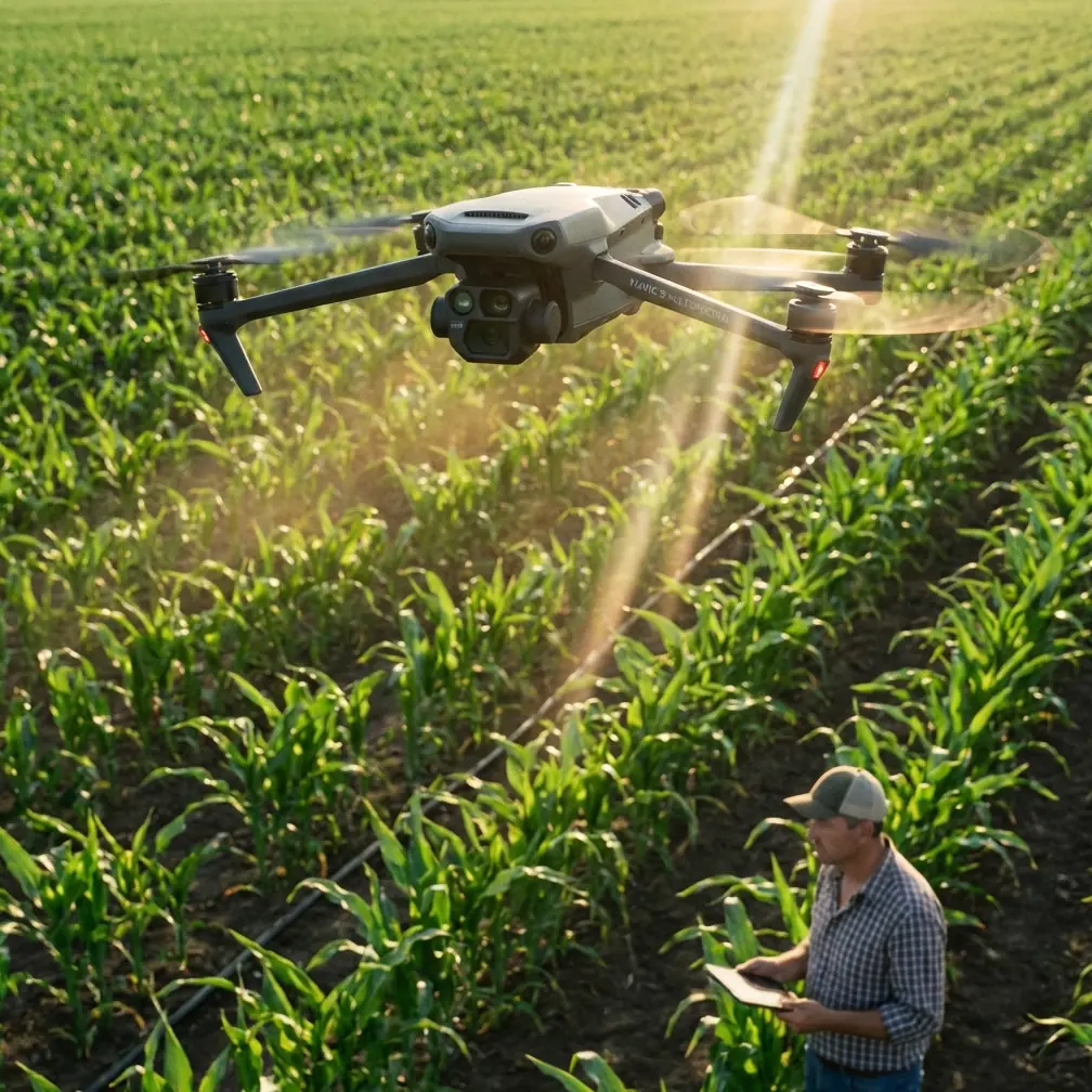
Vineyard managers working elevated terrain face a unique challenge: the same drone settings that work perfectly at sea level can produce inconsistent multispectral data above 2,000 meters. The Mavic 3M's four-band multispectral sensor captures vine stress indicators that human scouts miss—but only when operators understand how altitude affects every aspect of the mission.
This tutorial breaks down the exact workflow I've refined across 47 high-altitude vineyard surveys in regions from Mendoza's Uco Valley to Oregon's Willamette Heights. You'll learn battery protocols, sensor calibration sequences, and flight planning strategies that ensure your scouting data translates into actionable irrigation and treatment decisions.
Understanding High-Altitude Flight Dynamics
The Mavic 3M's maximum service ceiling sits at 6,000 meters, but that specification tells only part of the story. Reduced air density at elevation forces the motors to work harder to maintain stable hover, directly impacting battery consumption and flight duration.
At 2,500 meters, expect your standard 43-minute flight time to compress to approximately 34-36 minutes under optimal conditions. Factor in the temperature swings common to mountain vineyards—where morning fog gives way to intense afternoon sun—and that window shrinks further.
Motor Compensation and Stability
The aircraft's flight controller automatically adjusts motor output to compensate for thin air, but this creates downstream effects:
- Increased power draw reduces total mission coverage per battery
- Propeller efficiency drops by 8-12% compared to sea-level performance
- Wind sensitivity increases as the aircraft works harder to maintain position
- GPS hover accuracy may fluctuate during rapid temperature changes
Expert Insight: I pre-warm batteries to 25-28°C before every high-altitude mission. Cold batteries straight from the vehicle lose an additional 10-15% capacity. A simple insulated cooler with hand warmers keeps batteries at optimal temperature between flights—this single habit has saved countless aborted missions.
Multispectral Sensor Calibration Protocol
The Mavic 3M's integrated multispectral camera captures Green (560nm), Red (650nm), Red Edge (730nm), and Near-Infrared (860nm) bands simultaneously with the RGB sensor. At altitude, atmospheric interference patterns shift, making proper calibration non-negotiable.
Pre-Flight Calibration Sequence
Before launching any vineyard scouting mission above 1,500 meters, complete this calibration workflow:
- Deploy reflectance calibration panel on flat ground within the survey area
- Capture calibration images at mission altitude, not ground level
- Record ambient light conditions including cloud cover percentage
- Verify sun angle falls within 30-60 degrees from horizon for optimal spectral response
- Document atmospheric visibility for post-processing adjustments
The swath width you select directly impacts data quality at elevation. While the Mavic 3M supports variable overlap settings, high-altitude vineyard work demands 75% frontal overlap and 70% side overlap minimum. This redundancy compensates for the slight positional drift that occurs when RTK signals interact with mountainous terrain.
RTK Fix Rate Optimization
Centimeter precision depends entirely on maintaining consistent RTK Fix throughout the mission. Mountain vineyards present unique challenges—steep slopes, tree lines, and variable satellite visibility create fix rate fluctuations.
| Terrain Feature | Expected RTK Impact | Mitigation Strategy |
|---|---|---|
| Steep slopes (>15°) | Fix rate drops 5-10% | Increase overlap to 80% |
| Adjacent tree lines | Momentary fix loss | Plan flight paths parallel to obstructions |
| Valley shadows | Reduced satellite count | Schedule missions for optimal sun position |
| Metal trellis systems | Signal multipath errors | Fly at minimum 30m AGL |
| Rocky outcrops | Reflection interference | Avoid direct overflights |
Pro Tip: Monitor RTK Fix rate in real-time through DJI Pilot 2. If fix rate drops below 95% during a mission segment, mark that section for manual re-flight rather than trusting degraded positioning data. Vineyard managers make treatment decisions based on your maps—compromised accuracy wastes their inputs.
Mission Planning for Vineyard Blocks
High-altitude vineyards rarely present uniform rectangular blocks. Terraced plantings, contour-following rows, and irregular boundaries require thoughtful mission design to capture complete coverage without wasting battery on non-productive overflights.
Altitude Above Ground Level Considerations
The Mavic 3M's multispectral sensor achieves optimal ground sampling distance (GSD) at specific altitudes. For vine canopy analysis, target these parameters:
- Individual vine assessment: 30-40m AGL, GSD of 1.5-2.0 cm/pixel
- Block-level stress mapping: 50-60m AGL, GSD of 2.5-3.0 cm/pixel
- Estate-wide overview: 80-100m AGL, GSD of 4.0-5.0 cm/pixel
Remember that AGL references ground level, not sea level. A vineyard block at 2,200 meters elevation with a 50-meter AGL flight altitude means the aircraft operates at 2,250 meters absolute—well within the performance envelope but requiring altitude-adjusted battery planning.
Flight Speed and Image Quality
Resist the temptation to fly faster to cover more ground per battery. The multispectral sensor requires adequate exposure time, and motion blur destroys spectral data integrity.
Optimal flight speeds for high-altitude vineyard scouting:
- Bright conditions (clear sky): 8-10 m/s maximum
- Overcast conditions: 6-8 m/s maximum
- Variable cloud cover: 5-6 m/s with manual exposure lock
Interpreting Multispectral Data for Vine Health
Raw multispectral captures require processing to generate actionable vegetation indices. The Mavic 3M's sensor configuration supports multiple index calculations, each revealing different aspects of vine condition.
Primary Indices for Vineyard Scouting
NDVI (Normalized Difference Vegetation Index) remains the standard for overall vigor assessment, but experienced scouts layer additional indices:
- NDRE (Normalized Difference Red Edge) detects chlorophyll variations invisible to NDVI
- GNDVI (Green NDVI) shows sensitivity to chlorophyll concentration in dense canopy
- SAVI (Soil Adjusted Vegetation Index) compensates for exposed soil between vine rows
For spray drift assessment and nozzle calibration verification, NDVI difference maps between pre-treatment and post-treatment flights reveal application uniformity. Inconsistent coverage patterns indicate calibration issues or environmental interference during application.
Battery Management Field Protocol
This section addresses the single most common failure point in high-altitude vineyard operations. I learned this lesson during a critical veraison survey in Argentina's Calchaquí Valley—a mission that should have required three batteries consumed five due to poor thermal management.
The Warm Battery Rotation System
Carry minimum four batteries for every two-battery mission plan. This redundancy accounts for:
- One battery actively flying
- One battery warming in insulated storage
- One battery cooling after recent use
- One battery as emergency reserve
Never insert a battery below 20°C into the aircraft. The Mavic 3M's battery management system will limit output to protect cells, reducing available power precisely when altitude demands maximum performance.
Between flights, store discharged batteries in a separate container from charged units. Warm discharged batteries continue generating heat that can push temperatures past optimal ranges, while cold charged batteries benefit from proximity to recently-used warm packs.
Common Mistakes to Avoid
Skipping ground calibration because "the sky is clear": Atmospheric conditions at 2,500 meters differ dramatically from valley floors. Calibrate at mission altitude every session.
Using sea-level flight time estimates: Plan for 20-25% reduced flight duration and build buffer time into every mission segment.
Ignoring wind speed at altitude: Surface winds rarely reflect conditions at 50-80 meters AGL. The Mavic 3M handles wind well, but fighting gusts drains batteries faster than any other factor.
Processing multispectral data without atmospheric correction: High-altitude captures require specific radiometric calibration. Generic processing workflows produce misleading vegetation indices.
Flying during rapid temperature transitions: The hour after sunrise and before sunset creates thermal instability that affects both aircraft performance and spectral data quality. Schedule missions for mid-morning or mid-afternoon stability windows.
Frequently Asked Questions
How does the Mavic 3M's IPX6K rating hold up in mountain vineyard conditions?
The IPX6K protection rating handles morning dew, light mist, and unexpected drizzle common to mountain vineyards. However, this rating assumes normal operating temperatures. At high altitude with cold batteries, moisture resistance may be compromised at seal points. Avoid flying through visible precipitation regardless of the protection rating.
What RTK base station setup works best for steep vineyard terrain?
Position your RTK base station at the highest point within the survey area with clear sky visibility in all directions. For vineyards spanning significant elevation changes, a central high-point placement typically maintains better fix rates than edge positioning. Ensure the base station has minimum 15-degree elevation mask to filter low-angle satellite signals prone to terrain interference.
Can I use the same multispectral processing workflow for high-altitude and low-altitude vineyard data?
No. High-altitude captures require adjusted atmospheric correction parameters in your processing software. Most professional platforms like Pix4D or DroneDeploy allow custom atmospheric profiles—create specific presets for your elevation ranges. Using low-altitude defaults at 2,000+ meters introduces systematic errors that compound across large vineyard blocks.
Ready for your own Mavic 3M? Contact our team for expert consultation.