Mavic 3M Guide: Scouting Windy Venues With Better Data
Mavic 3M Guide: Scouting Windy Venues With Better Data, Not Better Luck
META: A practical expert guide to using DJI Mavic 3M for windy venue scouting, with multispectral workflow tips, RTK precision considerations, drift awareness, and accessory ideas that improve field results.
Wind changes everything in aerial field scouting. Not just aircraft handling. Data quality, repeatability, takeoff choices, image overlap, and the confidence you can place in the map afterward all start to shift when gusts arrive.
For teams using the Mavic 3M to evaluate agricultural blocks, orchards, test plots, turf sites, or infrastructure-adjacent land, the real challenge in windy conditions is rarely “can it fly?” The better question is whether the mission will still produce dependable multispectral outputs that support a decision. That distinction matters.
I approach this as an academic problem first and an operational one second. If the purpose of the flight is scouting, then the mission has to preserve signal quality and positional consistency well enough that the data still means something once the aircraft is back on the ground. A flight that merely survives the wind is not the same as a flight that produces useful agronomic or survey-grade insight.
Why windy venue scouting is different on the Mavic 3M
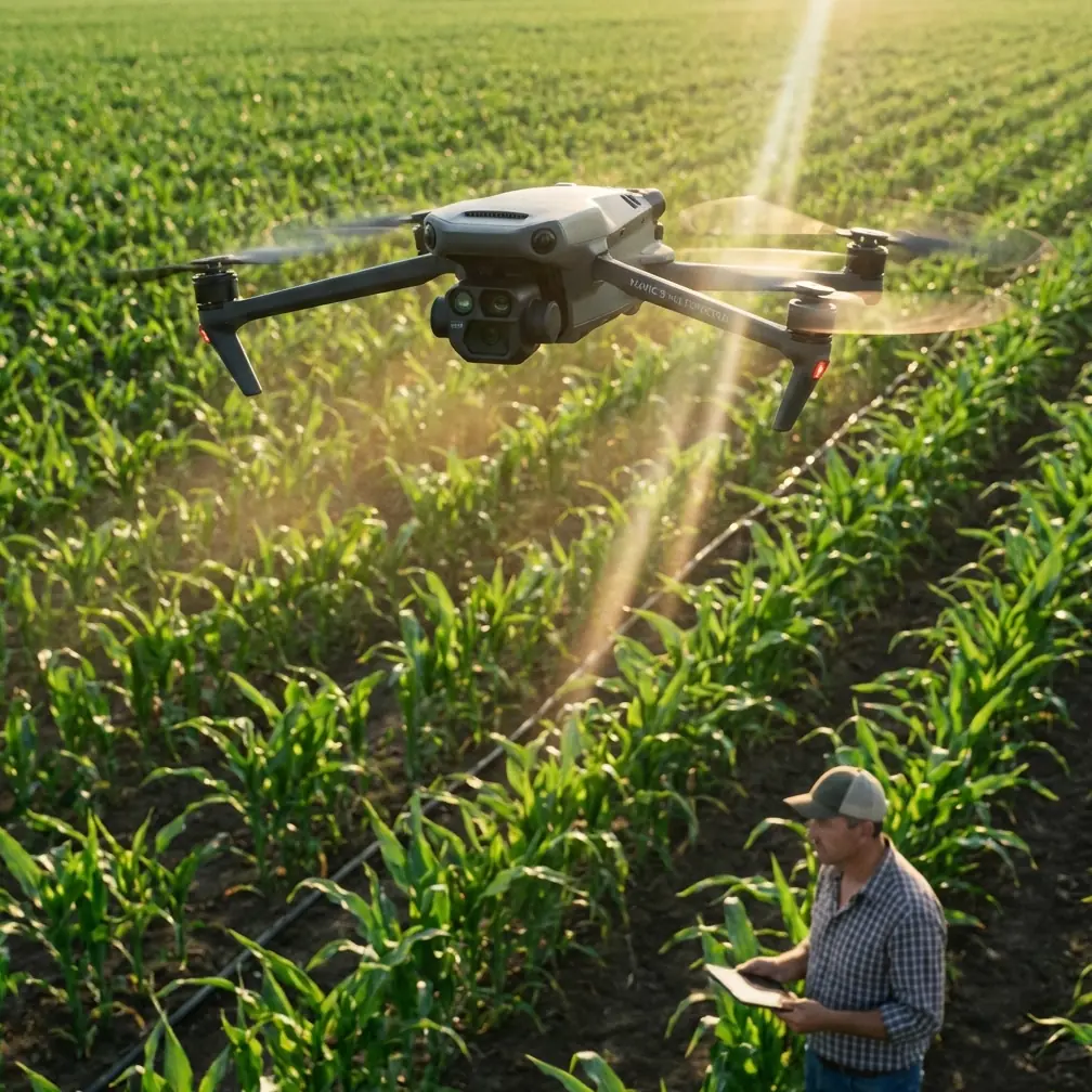
The Mavic 3M sits in an interesting category. It is compact, deploys quickly, and is often used for site checks that need to happen before a larger spraying or treatment plan is approved. That makes it ideal for short-notice scouting. But wind exposes the tradeoff that all compact platforms share: small aircraft can still deliver serious results, yet the margin for poor planning narrows fast.
When you are scouting a venue in wind, three things start to matter more than pilots sometimes admit:
- Target geometry
- Flight consistency
- Interpretation discipline
Target geometry is simple. A vineyard on a slope, a sports turf site with open crosswinds, or a field bordered by tree lines will each create different turbulence behavior near the surface. The Mavic 3M may handle the route, but image stability and line tracking can degrade in pockets rather than across the whole mission.
Flight consistency is where RTK performance, overlap planning, and route direction come into play. If you are expecting centimeter precision, the venue itself can interrupt how smoothly you achieve and maintain that precision. A headline specification is one thing. A stable RTK fix rate on a difficult site is another.
Interpretation discipline matters because wind can create visual symptoms that are easy to misread. In crop work especially, a stressed patch seen in multispectral data may reflect real canopy issues, but it can also become harder to compare against previous missions if acquisition conditions changed too much. When scouting venues, the goal is not to force certainty where the flight conditions only justify caution.
Start with mission design, not stick skill
A lot of operators think windy-site success begins in the air. Usually it begins ten minutes earlier.
The most useful mindset comes from a place you would not expect: training methodology. One of the reference documents describes complex model-aircraft maneuvers as combinations of simpler building blocks, especially loops and rolls. That principle translates well here. A good windy scouting mission is not one heroic flight. It is a sequence of simple, controlled decisions stacked properly.
For Mavic 3M work, that means breaking the mission into parts:
- safe launch and recovery zone
- crosswind and headwind route logic
- altitude choice
- overlap tolerance
- fallback coverage plan
- repeat-flight threshold
If any one of those pieces is weak, the final map may look acceptable while hiding inconsistencies that matter later.
I recommend scouting the venue itself before launching the formal mission. Walk the site edge. Look for wind corridors between structures, abrupt terrain transitions, irrigation hardware, tree shelter belts, and reflective surfaces. On exposed sites, you may find that one side of the venue is calm enough for takeoff while another side is where the aircraft will encounter the strongest lateral push.
That matters because launch location affects battery reserve strategy. It also affects whether your final leg will be flown into the wind or with it. For a compact mapping platform, that is not a small detail.
The hidden value of precision in wind
People often throw around the phrase centimeter precision as if it solves everything by itself. It does not. Precision is only valuable if the flight environment lets you preserve it consistently throughout the mission.
This is where the Mavic 3M becomes more than a camera drone. When you are scouting a venue for later treatment planning, drainage analysis, stand variability, or boundary confirmation, precision determines whether you can trust edge conditions and revisit the same site with meaningful alignment.
In windy environments, positional confidence is operationally significant for two reasons.
First, it helps reduce ambiguity when comparing passes or repeated missions. If your venue scouting is intended to guide later action such as ground inspection, nozzle planning, or selective treatment, you need confidence that a stressed band on the map is where you think it is.
Second, it reduces the temptation to “average out” bad collection with interpretation. That is a subtle but common error. Operators see a rough mission, then rely on broad patterns rather than disciplined geospatial confidence. Good RTK behavior helps avoid that trap.
Still, don’t confuse available RTK with guaranteed field performance. Venue geometry, sky visibility, and wind-driven attitude changes can all influence practical results. On difficult sites, watch your fix status and plan for reflight if the mission quality is drifting below the standard your downstream workflow requires.
Multispectral scouting in wind: what actually changes
Wind affects more than aircraft position. It changes the subject too.
Leaves move. Canopy texture shifts. Thin stands flicker. Turf lays over. These are not dramatic effects from the pilot’s perspective, but multispectral interpretation is sensitive to inconsistency. If one area was captured during a stronger gust band than another, surface appearance and canopy presentation can vary just enough to complicate comparisons.
That does not make the mission worthless. It simply means the purpose of the mission should guide the threshold for acceptance.
If your goal is broad venue qualification—finding drainage patterns, obvious weak zones, plant vigor variation, access issues, blocked corners, or patchy establishment—the Mavic 3M remains highly useful in wind as long as flight execution stays orderly.
If your goal is tighter comparative analysis over time, be more selective. Match acquisition windows as closely as you can. Similar sun angle, similar crop stage, and similar wind conditions matter more than many teams expect.
This is also the point where swath width becomes practical rather than theoretical. In wind, operators sometimes want to widen coverage logic to finish faster. The tradeoff is that a more aggressive plan can increase the burden on image consistency and overlap integrity. A narrower, more conservative collection strategy may actually yield better downstream value, even if it takes another battery.
Why spray drift still belongs in a scouting conversation
The Mavic 3M is not the application aircraft, but venue scouting is often the stage where treatment risk is first recognized. That is why spray drift belongs in the discussion.
A windy scouting mission can reveal things that later influence whether spraying should happen at all, and if so, under what constraints. Buffer-sensitive edges, neighboring crops, water channels, public paths, or uneven canopy exposure all show up more clearly when you are looking at the site through a planning lens rather than a treatment lens.
This is where multispectral and precision mapping start serving the larger workflow. Good scouting can identify:
- exposed perimeter zones where drift sensitivity is elevated
- stressed edges that may not benefit from blanket application
- irregular vigor patterns that point toward spot treatment instead of broad coverage
- access and obstacle patterns that affect later operational geometry
And once you move from scouting to action planning, nozzle calibration enters the story. Calibration is not something the Mavic 3M performs, but scouting data can influence whether your eventual application setup should prioritize droplet behavior differently on exposed blocks. If the venue is consistently windy, your treatment team should not be making that judgment from memory alone. They should be using mapped site conditions and observed edge risk.
That is one of the strongest arguments for using the Mavic 3M well: the aircraft is not just collecting pictures. It is improving the quality of later operational decisions.
A useful accessory upgrade for exposed sites
One of the simplest third-party additions I have seen improve windy-site work is a high-visibility foldable landing pad with weighted edge stakes or sand pockets. It is not glamorous, but it solves a real field problem.
On open venues, loose debris, grass movement, and uneven dirt surfaces can complicate launch and recovery. A stable pad reduces rotor wash contamination during takeoff and landing, gives the team a repeatable home point area, and helps maintain discipline when repositioning batteries and tablets in gusty conditions.
The accessory matters most when the venue is dusty, stubbly, or partially gravel-based. Multispectral work depends on clean execution from the first seconds of the mission. A sloppy takeoff area is an avoidable variable.
A second practical add-on is a sun hood for the controller or tablet. In bright, windy conditions, operators often spend too much energy just trying to see the screen. That degrades judgment. Better display readability improves route checks, fix monitoring, and the decision to abort or continue.
Neither accessory changes the aircraft’s aerodynamics. Both improve the mission.
Borrow a lesson from black-box thinking
Another reference document discusses aircraft “black boxes” and why they are engineered to survive brutal conditions: 1100°C, impact forces around 3400 times their own weight, pressure equivalent to 20,000 feet underwater, and data preservation for up to two years in extreme environments. It also mentions the underwater beacon transmitting at 37.5 kHz, once per second, for 30 days, with detection possible near 2 kilometers using the right listening equipment.
Those numbers belong to manned aviation, not small UAVs. Still, the lesson is relevant. Serious flight operations depend on recoverable evidence.
For Mavic 3M venue scouting, operational maturity means caring about flight records, route logs, RTK status history, mission notes, and environmental observations. Windy-site scouting is exactly where post-flight traceability earns its keep. If a map later looks inconsistent, you want a documented basis for explaining whether the issue came from acquisition conditions, positional quality, canopy motion, or route design.
This is one of the habits that separates casual drone use from professional remote sensing practice. Not tougher flying. Better documentation.
If your team is building a repeatable windy-site workflow and wants a practical checklist for Mavic 3M field setup, I’d suggest requesting one through this direct field support line: message our operations desk.
A field workflow that works
Here is the workflow I recommend for scouting venues in wind with the Mavic 3M.
1. Evaluate the site before powering up
Stand still for a minute. Watch vegetation layers, not just your windsock app. Trees, low grass, and tall crops often tell different stories.
2. Choose the launch area for recovery, not convenience
The best takeoff point is often the one that gives you the safest final return leg and the cleanest landing surface.
3. Confirm RTK behavior early
Do not assume that “available” means “stable.” Watch how quickly the system settles and whether the fix remains dependable as you move into the mission area.
4. Fly the cleanest route, not the fastest one
If one route orientation reduces crab angle and improves consistency, use it even if it costs a bit of time.
5. Be conservative with overlap in gusty conditions
Wind can introduce subtle collection irregularities. A tighter margin here usually pays back later.
6. Use multispectral outputs for pattern recognition first
In difficult conditions, the safest interpretation is often at the zone level before drilling into finer claims.
7. Document the environment
Record wind character, gust pattern, cloud movement, launch location, and any anomalies in fix behavior. These notes matter when comparing missions later.
8. Know when to refly
A second short mission in better conditions is often more valuable than overinterpreting a compromised one.
The real objective: decision-grade scouting
The Mavic 3M is at its best when it reduces uncertainty before larger operational commitments are made. On windy venues, that benefit becomes even more obvious. You are not just mapping a site. You are deciding whether later agronomic action, detailed inspection, or treatment planning will rest on solid ground.
Used carefully, the aircraft gives you three things that are difficult to replace with guesswork: multispectral context, positional discipline, and repeatable venue records. Add a few simple accessories, respect wind as a data-quality variable rather than merely a flight challenge, and the Mavic 3M becomes a much sharper scouting tool.
That is the standard worth aiming for. Not whether the drone can get through the wind, but whether the data can survive contact with real operational decisions.
Ready for your own Mavic 3M? Contact our team for expert consultation.