Mavic 3M in Dusty Venue Scouting: A Field Report on Signal
Mavic 3M in Dusty Venue Scouting: A Field Report on Signal Discipline, Risk Planning, and Why Protection Now Matters
META: A field report on using the DJI Mavic 3M for dusty venue scouting, with antenna positioning advice, RTK considerations, multispectral value, and practical risk planning tied to new drone protection trends.
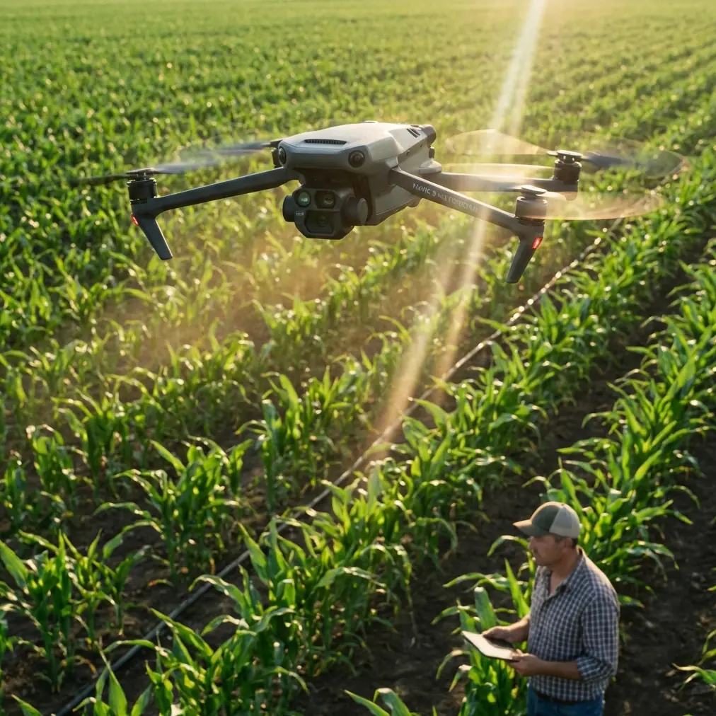
Dust changes how a drone job feels.
Not always in the obvious way. People tend to think first about lens haze, motor wear, or whether the landing zone is clean enough. Those matter. But when you’re scouting large, dusty venues with a Mavic 3M, the bigger operational story is usually a three-part one: signal discipline, data reliability, and what happens if something still goes wrong.
That last point has started getting more attention across the UAV industry. At the 10th World Drone Congress, which opened on May 21, 2026, one of the more telling signs of market maturity was not a new aircraft or a louder product launch. It was the visibility of support infrastructure. At booth 1D114, Hangying Feibao showed a protection service built for industry drone operations, covering accidental airframe loss, third-party liability, theft, and even accidental injury protection for pilots. The booth reportedly drew sustained traffic from attendees and industry partners asking questions on-site.
That matters to Mavic 3M operators more than it might seem at first glance.
Dusty venue scouting is not extreme aviation. It is normal commercial work. Yet normal commercial work is where losses happen: hurried deployment, vehicles moving nearby, temporary structures, inconsistent GNSS conditions, and a pilot trying to collect clean imagery before site activity shifts again. If you fly a Mavic 3M for pre-construction checks, agriculture-adjacent land assessment, event-ground planning, or infrastructure inspection around dry, particulate-heavy terrain, you’re operating in the exact zone where professionalism shows up in details, not drama.
This field report is about those details.
The Mavic 3M is only as useful as the workflow around it
The Mavic 3M earns its place because it combines efficient aerial coverage with multispectral capability and tight positioning workflows. That makes it attractive for dusty sites where you are not just making pretty maps. You may be checking drainage scars, vegetation stress around the perimeter, access corridors, soil disturbance, or pre-work conditions that affect logistics later. In some jobs, the RGB layer is enough. In others, multispectral data gives you a faster read on surface variation than a standard camera pass ever could.
But the aircraft does not create reliability by itself.
Reliability comes from how the site is approached. In dry environments, three questions should shape the mission before takeoff:
- Will the link remain clean across the whole route?
- Will the positioning hold at the precision the deliverable requires?
- Is the operation protected against the routine losses that can derail a project?
The first two are flight problems. The third is a business problem. Experienced operators learn quickly that all three belong in the same conversation.
Antenna positioning advice that actually improves range
A lot of pilots think “point the antennas at the drone.” That is a common mistake.
For maximum range and stronger link quality, the flat faces of the antennas should be oriented toward the aircraft, not the tips. The energy pattern is broadside, not straight off the end. In practice, when scouting a dusty venue, I tell crews to do this:
- Keep the controller chest-high, not down at the waist.
- Angle the antennas so their broad surfaces face the aircraft’s expected flight corridor.
- Re-adjust as the drone changes altitude or shifts to the side of the pilot position.
- Avoid standing next to trucks, metal fencing, containers, stage truss, or temporary towers that can distort or block signal paths.
This becomes especially important on wide, dusty properties where you may be tempted to stand beside a vehicle for shade or convenience. Don’t. The easiest way to reduce range is to let your own operating position become part of the obstruction environment.
Dusty venues often have another issue: subtle visual flattening. Everything looks the same from the ground. That can encourage poor pilot placement because the site appears open when it actually contains low-profile obstacles, heat shimmer, and reflective clutter. A clean RF stance solves part of that before the drone ever leaves the ground.
Why RTK discipline matters when the terrain is visually ambiguous
The Mavic 3M’s value climbs sharply when your RTK fix rate is stable.
On dusty sites, visual cues can be weak. Freshly graded surfaces, pale soil, tire tracks, and loose particulate can make image interpretation harder later, especially when stakeholders expect repeatable comparison between surveys. Centimeter precision is not just a nice specification in that context. It is what lets the same corridor, plot edge, or disturbed section line up cleanly over time.
That’s why I treat RTK setup as part of the venue-scouting brief, not a background setting.
If the mission objective includes change detection, drainage evaluation, staking support, or agronomic interpretation on dry parcels, you need to confirm that the aircraft is maintaining the fix quality required for the job. A weak workflow here creates downstream confusion: was that edge movement real, or did the map shift? Did vegetation stress spread, or did the alignment drift?
This matters even more if the site has adjacent work involving spray drift assessment or future application planning. Dusty ground and stressed vegetation can be misread if the spatial consistency is loose. The Mavic 3M’s multispectral payload helps, but only when the geometry holds.
Multispectral scouting in dry conditions is not just for crops
People pigeonhole the Mavic 3M as an agriculture aircraft. That leaves value on the table.
On dusty venues, multispectral capture can support more than crop health analysis. It can reveal boundary inconsistencies, identify stressed vegetation around drainage lines, show where vehicle movement is compacting or disturbing surface conditions, and help separate true plant stress from surface discoloration. In transitional sites—places that sit between agricultural, industrial, and infrastructure use—this can be the difference between guessing and knowing.
That also ties directly to operational planning. If you’re evaluating swath width for later work, or considering where application routes might run in surrounding land, the scout flight becomes your baseline dataset. Multispectral context can improve decisions about access paths, buffer zones, and spray drift sensitivity near the venue edge.
And yes, nozzle calibration may seem far removed from a Mavic 3M scouting mission, but in the real world these tasks connect. Many operators are called in early to inspect and map, then later to support agricultural or vegetation-management workflows around the same site. If the initial data is spatially clean and the vegetation interpretation is honest, the later application planning becomes more precise and more defensible.
Dust exposure changes your launch and recovery priorities
Dust punishes carelessness on the ground more than in the air.
In flight, the Mavic 3M is doing what it was built to do. On the ground, though, every rushed battery swap invites contamination. Every launch from a powdery patch increases the chance of particulate intrusion or dirty optics. Even a platform with strong environmental resilience does not become invulnerable because the spec sheet looks reassuring. If you’re working around equipment rated for harsh conditions, such as IPX6K-class agricultural hardware in adjacent workflows, it’s easy to assume the same level of field abuse is acceptable across the board. That assumption is expensive.
My field preference is simple:
- Launch from a raised pad or hard case lid when possible.
- Keep battery changes off the soil.
- Face downwind during setup so loose dust moves away from the aircraft and controller.
- Inspect the gimbal area after every dusty recovery, not just at the end of the day.
These are basic habits, but they are exactly the habits that reduce the sort of accidental damage now being explicitly addressed by specialized drone protection services.
The bigger story from the 2026 drone congress
The booth traffic at 1D114 tells you something the hardware headlines often miss.
The UAV market is entering a stage where support systems are becoming part of operational credibility. Hangying Feibao’s service model—covering accidental airframe damage, third-party liability, theft, and pilot accidental injury—reflects the real concerns of working operators. Not hobby anxieties. Business exposures.
For Mavic 3M users, that is especially relevant because this aircraft often sits in the middle ground between lightweight general-purpose drones and heavier dedicated field systems. It gets deployed frequently, by lean teams, across variable terrain. That means utilization is high, but so is the accumulation of small risks.
A dusty venue scout can involve:
- tight time windows,
- repeated takeoffs and recoveries,
- road traffic or contractor movement nearby,
- uncertain security if gear is staged from vehicles,
- and pressure to deliver same-day outputs.
None of that sounds dramatic. That is the point. Most losses are ordinary.
The industry presence of these protection services signals that drone operations are being treated more like established field professions. You plan the mission, manage the data, and protect the operation. That is a healthier model than pretending pilot skill alone can eliminate every incident.
What obstacle-detection research quietly teaches venue scouts
One of the more useful technical reminders comes from a different corner of UAV research. In a study covering obstacle-detection benchmarking on more than 23,000 frames, researchers showed that a lighter-compute stereo approach could trade a limited amount of performance for a substantial gain in speed, while still outputting point clouds compatible with planning and visualization tools. They also reported that only 8.2% of detected pixels fell into a “no match” category in one benchmark condition.
Why bring that up in a Mavic 3M field report?
Because venue scouting is often about making fast decisions from imperfect environments. Dust, haze, bright soil, repetitive textures, and moving machinery all degrade visual confidence. The lesson is not that your mission should imitate that research system. It is that speed, computational efficiency, and compatible 3D outputs have real operational value when the site is changing beneath you.
A Mavic 3M pilot scouting a dusty venue should think the same way:
- get the data quickly,
- preserve positional integrity,
- and produce outputs that plug into planning tools without friction.
That is what separates useful reconnaissance from a folder full of images no one can act on.
A note on pilot workload and human protection
There is another detail in the Hangying Feibao model worth paying attention to: protection for pilot accidental injury.
That might seem secondary when discussing a compact aircraft like the Mavic 3M, but fieldwork is fieldwork. Dusty sites come with uneven ground, vehicle movement, heat load, and the temptation to multitask during setup. If the operator is also handling batteries, checklists, client communication, and spotter coordination, fatigue creeps in quickly. A tired pilot is not just more likely to make a stick error. They are more likely to trip, rush, forget a lock, or mismanage launch position.
The market is finally acknowledging that drone operations involve both aircraft risk and human risk. That is overdue.
Practical setup sequence I use on dusty venue jobs
Before launch, this is the sequence I recommend for Mavic 3M scouting missions in dry, dusty environments:
Choose pilot position first, not launch point first.
Find the cleanest RF line and best view of the flight corridor.Set antenna orientation deliberately.
Present the broad faces toward the aircraft’s route, and adjust as the mission geometry changes.Confirm RTK status before committing to mapping legs.
If the fix is unstable, don’t assume it will sort itself out mid-mission.Define the data objective clearly.
RGB overview, multispectral analysis, corridor inspection, or comparison baseline. The flight pattern should follow the question.Control dust during turnaround.
Use a pad, shield the aircraft from windblown particulates, and inspect optics and gimbal after landing.Think about liability before the incident, not after it.
If your operation scales across multiple sites, build protection into the workflow. If you need a direct channel to discuss drone field support options, use this WhatsApp contact for UAV operations coordination.
That list is not glamorous. It is profitable. It protects data quality and reduces avoidable friction.
The Mavic 3M is strongest when treated like a professional instrument
The drone itself is not the whole story. The real story is the operating standard around it.
A Mavic 3M flown over a dusty venue can produce highly usable reconnaissance, repeatable spatial outputs, and meaningful multispectral insight. But those gains depend on old-fashioned field discipline: proper antenna orientation, careful RTK validation, clean launch practices, and a realistic approach to operational risk.
That is why the 2026 congress signal matters. When a service focused on accidental airframe loss, third-party liability, theft, and pilot injury draws strong attention on the exhibition floor, it tells you the market is growing up. Drone work is no longer just about what flies. It is also about what protects continuity when work gets messy.
And dusty venue scouting is always a little messy.
Ready for your own Mavic 3M? Contact our team for expert consultation.