Mavic 3M Scouting in Remote Venues: A Field Case Study
Mavic 3M Scouting in Remote Venues: A Field Case Study on Weather, Clean Sensors, and Better Decisions
META: A practical Mavic 3M case study for remote venue scouting, covering multispectral planning, weather risk, sensor cleaning, and why disciplined pre-flight routines matter.
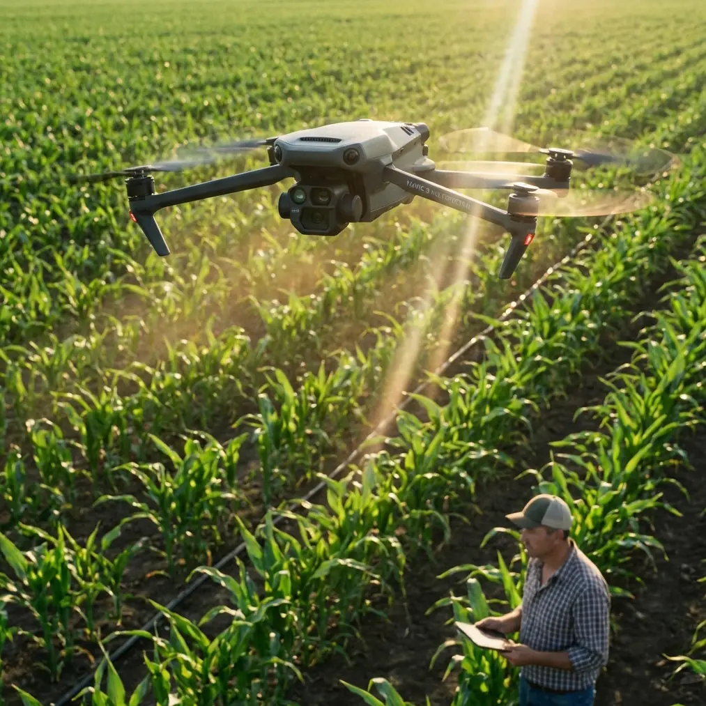
Remote venue scouting sounds simple until the site is three hours from the nearest support road, bordered by water on one side, rising ground on the other, and a weather pattern that changes faster than your crew can repack batteries.
That is where the Mavic 3M becomes less of a camera drone and more of a decision tool.
I have been asked more than once whether a platform like the Mavic 3M is excessive for venue scouting. My answer depends on what “scouting” means. If the job is just taking pretty overhead photos, then yes, you can get by with less. But if you need to evaluate drainage, ground variability, access routes, vegetation stress near temporary infrastructure zones, and layout feasibility in a remote environment, the Mavic 3M starts making a lot of sense. Its multispectral capability changes the conversation from “what does the site look like?” to “what is the site telling us before it becomes a problem?”
This matters even more in a market where drone availability is no longer the limiting factor. One recent report discussed outside estimates that China may produce as many as 700,000 drones per month, while arguing that even that figure may understate actual manufacturing capacity. The operational takeaway is not abstract. Platforms are abundant. Hardware is no longer rare. The differentiator is how well teams use aircraft like the Mavic 3M in disciplined workflows, especially when the job site is remote and the margin for error is thin.
The assignment: remote venue viability, not just aerial media
A recent scouting brief I reviewed involved a remote coastal event site with mixed terrain: compacted service roads, open grass sections, low-lying wet patches, and a tree line that created wind turbulence near the intended operations area. On paper, the mission looked routine. In the field, it was not.
The client wanted answers to practical questions:
- Which access routes would stay usable after rain?
- Where would temporary structures place the most stress on the ground?
- Which zones had uniform vegetation cover, and which were already showing stress?
- Could the site support repeatable setup windows if weather shifted?
That last point is where a lot of crews underestimate the mission. Drone operations in remote venues are rarely defeated by flight planning software. They are defeated by incomplete environmental judgment.
The reference materials here are useful because they connect two ideas many operators keep separate: drones are increasingly used for remote sensing and environmental assessment, and weather remains one of the biggest variables affecting safe flight. One educational source describes UAV use in agriculture, yield assessment, farmland remote sensing, 3D point cloud generation, and even atmospheric data collection such as temperature, pressure, humidity, wind, and cloud conditions. Another technical source goes deeper into flight hazards, especially wind shear, low cloud, and the way local geography amplifies those risks.
For Mavic 3M users scouting venues, those two threads belong together.
Why the Mavic 3M is stronger than a standard visual-only scouting workflow
The Mavic 3M’s value in this kind of mission is not just that it flies efficiently. It is that it gives you another layer of evidence.
When you are evaluating a remote venue, RGB imagery tells you what is visible. Multispectral data helps reveal uneven plant vigor, moisture-related stress patterns, and surface transition zones that may not stand out to the eye. Those patterns can influence where parking overflow should not go, where pedestrian traffic may damage already fragile ground, and where temporary utility corridors could become unstable after a weather event.
This is one reason agricultural drone logic transfers well to venue scouting. The source document notes that drones are already used in crop protection, fertilization, seeding, disaster warning, yield evaluation, and agricultural remote sensing. Strip away the crop-specific objective and the core lesson remains: UAVs excel when a site needs to be read as a system, not just photographed as a landscape.
That is exactly what the Mavic 3M does in remote reconnaissance.
The pre-flight step crews skip too often: cleaning before calibration and takeoff
Here is the part that sounds mundane but saves real trouble: clean the aircraft before the mission, especially the vision sensors, camera glass, and airframe surfaces around sensing and cooling areas.
I am not talking about cosmetic cleaning. I mean a deliberate pre-flight wipe-down after transport and before calibration checks.
Remote venues are dirty in specific ways. Salt mist near water. Fine dust on access roads. Pollen at field edges. Mud splash from utility vehicles. A drone can arrive at the launch point looking fine and still have enough residue on forward optics or downward sensing areas to degrade confidence in low-altitude work, landing behavior, or image consistency.
That matters for any aircraft, but it matters more when the mission depends on comparable data sets. Multispectral workflows are unforgiving of sloppy field habits. If your goal is to compare site sections accurately, start by removing variables you can control.
This also ties back to safety. The aviation weather reference highlights the need for strong team coordination and instrument awareness when conditions become unstable. A clean aircraft will not solve wind shear. But a dirty sensor suite combined with gusty low-level conditions is exactly how routine operations become messy. If your site is remote, re-flying may cost half a day. Better to build the discipline into the first ten minutes on site.
My recommended sequence is simple:
- Unpack and inspect the aircraft body for dust, moisture residue, and transport contamination.
- Clean optical surfaces and sensor windows with the right materials.
- Verify propellers and landing surfaces are free from grit.
- Power on and check system status before committing batteries to mapping work.
- Reconfirm weather observations at ground level, not just the app forecast.
That fifth step deserves more respect than it usually gets.
Weather at the venue is often not the weather in the forecast
One of the strongest details in the technical reference is that wind shear is often driven not only by weather systems such as strong convection, fronts, and low-level jets, but also by geography and environment. Mountains, large water areas, and tall buildings all increase the chance and intensity of wind shear.
That is a direct warning for remote venue scouts.
A site beside a reservoir, along a beach edge, or under rising terrain may produce low-level wind behavior that feels disproportionate to the regional forecast. The same reference explains operational signs and prevention methods: watch for visible indicators around convective activity, monitor airspeed and altitude behavior, strengthen crew coordination, and do not try to fly through severe shear or strong downdraft zones.
For a Mavic 3M venue survey, the significance is practical:
- Water-adjacent sites can generate unstable low-altitude airflow.
- Terrain breaks can produce abrupt speed and attitude changes.
- Tree lines and temporary structures can channel crosswinds into mapping lanes.
- Low cloud or coastal layer effects can reduce visual confidence during landing and recovery.
The source also notes that low cloud bases in coastal regions can sit below decision thresholds, interfering with visual approaches. In small-UAV terms, that translates into a simpler truth: coastal haze and low cloud can compress your operational margin fast, especially late in the day.
That is why I tell teams not to over-focus on mission speed. Focus on mission timing.
An early launch window with stable light wind is usually worth more than squeezing in one extra battery under deteriorating conditions.
Case study workflow: how I would run the Mavic 3M on a remote venue recce
For this kind of venue, I would split the operation into three layers.
Layer 1: high-confidence overview pass
Start with a broad visual and multispectral pass to establish access, drainage signatures, and vegetation consistency across the full venue footprint. This is the “what are we dealing with?” layer. If the site includes soft margins or recently saturated ground, multispectral differences often appear before boots on the ground fully appreciate them.
Layer 2: problem-zone interrogation
Then fly targeted segments over:
- likely vehicle staging areas
- crowd flow corridors
- edge zones near water
- sloped ground behind structure placement candidates
- any patch where visual color and plant vigor diverge
This is where the Mavic 3M earns its keep. A standard visual scan might confirm a patch is green. Multispectral assessment can suggest that not all green is equal. For venue planning, that can help avoid putting repeated foot traffic or support loads onto weak sections.
Layer 3: validation with ground truth
No good operator treats drone output as sacred. Use the data to direct the walk, not replace it. If a section shows stress signatures or inconsistent reflectance, inspect it on foot. Probe the ground. Check drainage pathing. Confirm whether the issue is moisture, compaction, species variation, or shadow influence.
This blend of remote sensing and field verification is how you avoid false confidence.
A side lesson from mapping and 3D point clouds
The educational source also points out that drones can generate high-accuracy 3D mapping and point cloud products for terrain mapping and geological monitoring. That matters for Mavic 3M venue scouts because remote venues are often judged too loosely in elevation terms. “Mostly flat” is not a planning standard.
Subtle grade changes can determine:
- runoff concentration after rain
- cable route safety
- temporary flooring needs
- accessibility performance
- generator and equipment placement risk
Even if your final output is not a full engineering-grade terrain product, borrowing the mindset of mapping crews improves scouting quality. Think in surfaces, transitions, and repeatability—not just photos.
Where multispectral scouting intersects with agricultural discipline
The context hints around spray drift, nozzle calibration, swath width, and RTK fix rate come from agriculture, but they expose a broader truth: the most capable drone teams build habits around precision. They do not improvise every mission from scratch.
A venue scout using the Mavic 3M should think similarly. Maintain consistent flight lines. Watch overlap discipline. Track environmental changes from one sortie to the next. If your aircraft supports centimeter-level workflows through broader ecosystem tools, use that mindset even when the deliverable is operational planning rather than agronomy.
Remote work rewards consistency.
And if your crew needs a second opinion on planning a difficult venue mission, you can message a field specialist directly before committing to the deployment.
What the bigger drone manufacturing story really means for Mavic 3M users
That report about China’s drone production capacity being estimated at 700,000 units per month, and possibly even higher, tells us something bigger than scale. It tells us the industry has moved beyond novelty.
When production reaches that level, the conversation should shift away from whether drones belong in site scouting and toward what quality standards should govern their use. The Mavic 3M is not interesting because it is rare. It is useful because it allows a skilled operator to combine environmental interpretation, mapping logic, and disciplined flight operations in a compact field workflow.
That is the real edge.
Not hype. Not volume. Not a spec-sheet arms race.
Just better judgment, earlier in the planning cycle.
The takeaway for remote venue teams
If you are using a Mavic 3M to scout remote venues, treat the mission like a data collection exercise with aviation constraints, not a casual aerial look-around.
Clean the aircraft before launch. Pay attention to local weather behavior, especially near water, terrain breaks, and built obstacles. Use multispectral output to identify weak or inconsistent ground conditions that visual imagery can miss. Borrow rigor from agricultural and mapping operations, because those sectors already understand how much value comes from repeatable remote sensing rather than one-off flights.
The drone industry now operates at industrial scale. Your field process should too.
Ready for your own Mavic 3M? Contact our team for expert consultation.