How I’d Use the Mavic 3M to Scout Remote Venues Without Wast
How I’d Use the Mavic 3M to Scout Remote Venues Without Wasting a Field Day
META: A practical expert guide to using the Mavic 3M for remote venue scouting, with a focus on multispectral workflows, mapping outputs like DEM and DOM, RTK-grade precision, training, safety prep, and support realities.
Remote venue scouting sounds simple until you are the one standing at the edge of a rough access road, losing daylight, trying to decide whether a site is actually usable.
That is where the Mavic 3M earns its place.
Not because it is just another compact drone with a smart camera, but because it compresses site reconnaissance into a workflow that can produce decisions, not just pretty imagery. For readers evaluating the Mavic 3M specifically for remote scouting, the real question is not whether it flies well. It is whether it helps you leave a site with measurable answers: terrain shape, access constraints, vegetation pressure, drainage risk, and enough positional confidence to avoid a return trip.
That is the lens I want to use here.
The real problem with remote venue scouting
Most venue scouting failures are not dramatic. They are expensive in quieter ways.
A team drives hours to inspect a remote parcel, an agricultural edge site, a temporary event field, a rural construction laydown area, or a water-adjacent utility zone. On the ground, the view is fragmented. You can see the track in front of you but not the full slope transition. You can identify standing water in one corner but not the drainage pattern across the site. You can walk boundaries, but that still leaves blind spots behind tree lines, embankments, and irregular terrain.
Traditional manual surveying solves some of that, but slowly. One of the most useful facts from the reference material is still one of the most relevant today: UAV aerial survey work can quickly and automatically generate mapping outputs such as DEM, DOM, and DLG. That matters because remote scouting is often a race against time, weather, and logistics. A digital elevation model (DEM) shows how the site actually rises and falls. A digital orthophoto map (DOM) gives you an accurate overhead image rather than a perspective view that can mislead the eye. DLG-style linework supports boundary and feature interpretation in a structured way.
Those are not abstract acronyms. They are the difference between “this looks workable” and “this southern edge drops enough to complicate access after rainfall.”
The same source also emphasizes another operational truth: UAV implementation cycles are short, cost is relatively low, and the resulting high-precision surface and ground data can make up for the inefficiency and discontinuity of manual measurement. That is exactly the remote-scouting use case in one sentence. If your team is trying to screen multiple sites in limited time, speed without losing data quality is the whole game.
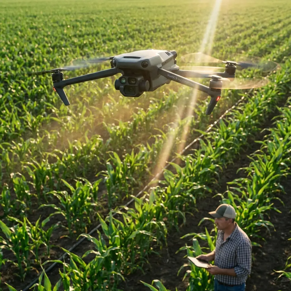
Why the Mavic 3M fits this kind of job
The Mavic 3M is especially interesting for scouting because it pushes beyond visual inspection. Its appeal is not just portability. It is the ability to combine fast mission execution with multispectral interpretation and centimeter precision workflows when RTK conditions are right.
For remote venues, that matters more than many buyers initially expect.
A standard RGB overview can show roads, structures, exposed soil, and shadows. Multispectral data can reveal vegetation vigor differences, wetness patterns, edge encroachment, and surface variability that a basic visual pass may flatten or hide. If you are scouting an open rural venue, a utility corridor, a staging field, or an agricultural interface zone, vegetation is not background scenery. It can define access limits, maintenance burden, drainage problems, and setup viability.
This is where a lot of people incorrectly pigeonhole the Mavic 3M as “only for agriculture.” That misses the point. In venue scouting, multispectral sensing can tell you whether the site’s green cover is consistent or patchy, whether one section is under stress, whether low areas are retaining moisture differently, and whether the access route crosses vegetation zones likely to change quickly over a season.
Even terms usually associated with ag work—spray drift, nozzle calibration, swath width—can still inform broader operational planning. Not because you are spraying a venue, but because remote sites are often adjacent to active farmland or managed landscapes. If a proposed venue or work area borders crop land, understanding drift risk, buffer needs, and vegetation boundaries becomes relevant to site suitability and scheduling. The Mavic 3M’s data helps expose those edges before they become coordination problems.
Start with the unglamorous step: pre-flight cleaning
Before any remote scouting mission, I pay attention to one boring step that saves more trouble than most software updates ever will: cleaning the aircraft and sensors before launch.
This matters because compact field drones tend to collect dust, pollen, dried moisture marks, and fine debris in transit, especially when you are scouting unpaved or agricultural areas. If your obstacle sensing surfaces, camera glass, or multispectral ports are carrying residue, you are building uncertainty into the mission before propellers even spin.
For a site-scouting workflow, that has direct safety and data consequences.
A dirty sensing surface can interfere with obstacle-awareness reliability in low-contrast conditions near brush, poles, or irregular structures. Contamination on optical components can reduce image clarity and consistency, which then affects stitched map quality. If you are trying to produce a clean DOM or interpret subtle multispectral differences across a site, that is not a cosmetic issue. It changes what you trust.
This pre-flight cleaning step is especially smart if you are moving between sites in one day. Dust from one location becomes image degradation at the next one. I treat it like battery checks: routine, not optional.
What a productive Mavic 3M scouting mission should produce
A remote scouting sortie should not end with “we got some footage.” That is tourism, not fieldwork.
A useful Mavic 3M mission should aim to generate a practical stack of outputs:
- an overhead orthomosaic for visual site review
- a DEM for terrain understanding
- feature interpretation for access routes, boundaries, and constraints
- multispectral layers for vegetation and moisture-related clues
- georeferenced observations you can compare later without guesswork
This is why the 2016 water-industry reference still has teeth. It notes that UAV data, once processed through photogrammetric adjustment or automated image stitching, can be turned into survey products and then further combined with professional analysis models. In remote venue work, that means the drone is not the final step. The drone is the data collection stage for a better planning decision.
If I am scouting a remote venue with the Mavic 3M, I am looking for answers to questions such as:
- Where are the genuine high and low points?
- Is vehicle access broad enough and stable enough?
- Are there wet pockets that visual inspection from the roadside would miss?
- Does vegetation indicate uneven drainage or maintenance neglect?
- Are there hidden grade transitions that affect setup zones?
- Can I define a safe and efficient operational footprint with confidence?
That is where RTK Fix rate becomes more than a technical bragging point. A strong RTK workflow supports repeatable, positionally reliable mapping. For venue scouting, that means when you mark a problem corner today, you can return or brief another team later with far less ambiguity. Centimeter-level positioning does not just help surveyors. It helps project managers avoid misunderstandings.
Why remote terrain favors drone-first scouting
The reference paper describes UAV advantages with unusual clarity: cloud-below operation, high timeliness, small-area focus, high definition, large scale, portability, and efficient mobility. That stack maps almost perfectly onto remote venue reconnaissance.
“Cloud-below operation” is easy to overlook, but practically it means UAVs remain useful in conditions where larger aerial capture methods may not fit the mission window. “Small-area focus” matters because many remote scouting jobs are not huge regional surveys. They are targeted parcels, corridors, embankments, compounds, staging grounds, ponds, fields, or watershed-adjacent sites. “High timeliness” matters because a remote site can change fast after rain, irrigation, grading, or vegetation growth.
The water-sector example in the source goes further, describing UAV LiDAR applications across provinces including Beijing, Jiangxi, Hunan, Henan, Anhui, Guizhou, Guangxi, Heilongjiang, and Guangdong for flood-disaster investigation and evaluation. Even though the Mavic 3M is not being framed here as a LiDAR platform, the operational lesson is still relevant: remote field decisions improve when airborne data collection replaces fragmented ground impressions across varied terrain.
For someone scouting venues in remote areas, the takeaway is simple. Do not rely on one walk-through and your memory. Build a site model.
Support, training, and risk management matter more than spec sheets
There is another reference detail that deserves more attention than it usually gets. One source describes a support ecosystem that includes 1:1 training guidance, system integration, installation and commissioning, rental, maintenance, after-sales service, and even a tailored flight liability insurance structure covering aircraft accidents and third-party protection.
This is highly relevant to Mavic 3M buyers, especially consultants, land managers, and operations teams who are expanding from basic drone use into structured scouting and mapping.
Why? Because remote work magnifies small mistakes.
A weak pre-mission checklist, poor mission planning, bad overlap settings, inconsistent calibration habits, or sloppy data handling can waste an entire field day. If you are sending teams into distant sites, training is not a nice extra. It is operational insurance. The mention of 1:1 training guidance in the reference is significant because personalized instruction closes the gap between owning a capable aircraft and actually extracting decision-grade outputs from it.
The insurance angle matters too. The source specifically mentions coverage including accidental crash scenarios and third-party protection. That is not merely administrative detail. It shapes how organizations can deploy drones at real sites with fewer internal objections from risk managers and project stakeholders.
If you are building a remote venue scouting program around the Mavic 3M and want to discuss setup, workflow, or training fit, it makes sense to message a field workflow specialist here.
Where the Mavic 3M still requires discipline
No honest article on field drone operations should pretend capability erases constraints.
The reference material points out several persistent barriers in civil UAV work: incomplete industry standards, evolving regulation, safety issues, supply-chain maturity, and technical limits in flight control, batteries, environmental adaptability, communication/navigation systems, and data processing.
That list remains useful as a planning checklist.
For the Mavic 3M in remote venue scouting, the practical implications are straightforward:
- Regulatory discipline matters. Remote does not mean unrestricted.
- Battery planning matters. Distance from the vehicle changes mission math.
- Environmental adaptability matters. Dust, wind, moisture, and heat all affect reliability.
- Navigation quality matters. RTK performance is only valuable when your workflow supports it.
- Data processing discipline matters. A rushed map can produce polished nonsense.
I would add one more field reality: people often under-plan landing and takeoff conditions in remote areas. Uneven ground, loose gravel, grass seed heads, and fine dust are all enemies of clean sensor data and safe starts. That loops back to the cleaning point. Safety systems work best when operators respect the small maintenance habits.
A better way to think about the Mavic 3M for scouting
The Mavic 3M should not be viewed as a camera drone that happens to map. For remote venue work, it is better understood as a compact site-intelligence tool.
Its value comes from stacking several advantages at once:
- portability for hard-to-reach locations
- rapid capture cycles for time-sensitive scouting
- multispectral insight for surface and vegetation interpretation
- RTK-enabled positional confidence
- map products that support team decisions after the field visit
That combination can save the most precious thing in remote operations: repeat travel.
When a mission is done well, you do not just return with imagery. You return with evidence. A terrain model that clarifies access. An orthomosaic that shows actual site layout. Vegetation data that flags maintenance or moisture concerns. Coordinates that let others act on your findings accurately.
That is the difference between scouting and guessing.
If your use case involves rural parcels, agricultural-edge facilities, utility-adjacent sites, watershed corridors, temporary field venues, or any location where ground inspection alone leaves too many unknowns, the Mavic 3M is not overkill. It is often the cleanest way to convert one visit into a usable planning record.
And in remote work, that is often what separates an efficient operation from a frustrating one.
Ready for your own Mavic 3M? Contact our team for expert consultation.