Scouting Windy Sites with the Mavic 3M: A Field Method That
Scouting Windy Sites with the Mavic 3M: A Field Method That Prioritizes Light, Stability, and Measurable Detail
META: Practical expert advice on using the DJI Mavic 3M to scout windy venues, capture reliable multispectral and visual data, and improve inspection and mapping outcomes with smarter flight timing and battery discipline.
Wind changes everything.
A site that looks straightforward on a calm morning can become a poor mapping environment by midday. Gusts alter aircraft attitude, blur image sequences, and push crews into rushed decisions. For operators planning venue scouting with the Mavic 3M, the real challenge is not simply getting airborne. It is collecting imagery that remains useful when you return to the office and need to defend what the data actually shows.
That is where a disciplined method matters more than hardware obsession.
One of the more useful reminders from recent photography guidance is that image quality begins with light, not equipment. The source material puts it plainly: photography is fundamentally the art of using light. It also identifies two windows that consistently help beginners and professionals alike—roughly the first hour after sunrise and the last hour before sunset. Those “golden” periods matter even more when scouting windy venues with a Mavic 3M, because they often overlap with calmer surface conditions and softer illumination. In practical terms, that means cleaner scene contrast, less harsh shadow breakup, and a better chance of repeatable image interpretation across vegetation edges, access roads, facades, drainage features, and temporary structures.
For Mavic 3M users, this is not an artistic side note. It is operational.
Why windy venue scouting is harder than it looks
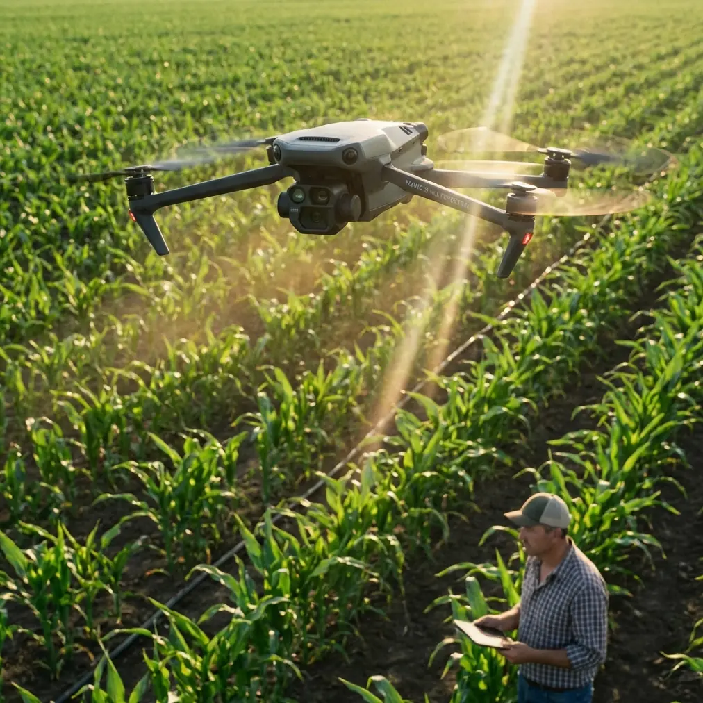
The Mavic 3M is often discussed in the context of multispectral capture, plant health workflows, and precision survey support. Yet in venue scouting, especially across exposed terrain or large open compounds, the aircraft’s value depends on whether you can preserve consistency from one flight line to the next. Wind interferes with that consistency in subtle ways. It changes ground speed, increases corrective motion, and can make oblique review images less uniform even when the mission technically completes.
If your goal is to assess terrain readiness, temporary installation zones, drainage paths, roof conditions, access bottlenecks, or ground disturbance, you do not just need images. You need images that are clean enough to compare.
This aligns with a second reference point from the engineering literature on UAV photogrammetry. That material highlights the value of drone-based digital photographic measurement for full-process observation of structural deformation and feature recognition. It specifically calls out use cases such as bridge cracks, structural displacement, steel deformation, slope faults, foundation movement, and broad-area building deformation monitoring. The significance for a Mavic 3M operator scouting windy venues is straightforward: the aircraft is most useful when flown as a measurement tool, not merely as a camera platform.
A windy site punishes casual flying. A measured workflow reduces that penalty.
Start with timing, not settings
Many pilots begin venue scouting by checking batteries, updating airspace conditions, and choosing altitude. Those are necessary steps, but they come after the first decision that actually shapes data quality: when to fly.
The photography source recommends avoiding harsh overhead light at midday. That advice is even more relevant from the air. Midday top light tends to flatten useful surface cues while producing unpleasant glare on roofing, pavement, standing water, and metal structures. In windy environments, operators also tend to work faster under those conditions because the aircraft is visibly fighting air movement. The result is a bad combination: poor light and rushed capture.
A better sequence is this:
- Fly the first reconnaissance pass within about one hour after sunrise when possible.
- Use that pass to identify wind corridors, exposed edges, and zones where the aircraft experiences repeatable drift or yaw correction.
- Save detailed oblique work and lower-altitude visual inspection angles for the calmest segment of the morning.
- Return near the last hour before sunset if the site requires comparative lighting or shadow analysis.
Soft light helps define edges and texture. That matters if you are reviewing berm integrity, erosion, staging surfaces, vegetation stress patterns, or temporary access lanes. Under diffuse cloud cover, which the photography article notes is ideal for close detail and still subjects, the Mavic 3M often performs especially well for broad visual consistency. Overcast conditions reduce hard shadow interruptions that can complicate visual interpretation of cracks, rutting, patch repairs, and uneven settlement.
The “clean frame” rule is critical from the air
The source article also stresses that good images require a clear subject and a clean frame. On the ground, that sounds basic. In UAV scouting, it becomes one of the most neglected habits.
Windy sites tempt pilots to over-collect. You may return with hundreds of images showing everything and proving nothing. The more useful discipline is to decide what the subject is for each orbit or line segment. Is it the roof edge? The drainage trench? The stage footprint? The retaining slope? The vehicle access turn radius? If the subject is undefined, the dataset becomes cluttered. And clutter in aerial review wastes analysis time.
For Mavic 3M missions, I advise dividing the site into three image classes:
1. Establishing frames
These show the whole venue or work area and explain context.
2. Decision frames
These are the images someone will actually use to approve, reject, or modify a plan.
3. Measurement-support frames
These are collected with repeatability in mind, so they can support comparison over time.
That framework comes directly from how drone imaging is used in engineering deformation monitoring. The engineering reference emphasizes long-term precise observation of structures and the comparison of point cloud or image-derived datasets to determine whether a structure has changed shape. Even if your windy venue is not a bridge or dam, the principle transfers well. If you cannot reproduce the view and isolate the subject, your future comparison loses value.
How the Mavic 3M fits this job better than a generic camera drone
The Mavic 3M’s real strength in scouting is not simply that it flies compactly. It is that it can bridge visual review and multispectral context in a single field session.
That matters in venues where the surface tells only part of the story. A grassy event field, roadside shoulder, embankment, or landscaped access route may look acceptable in RGB imagery while hiding stress patterns that affect stability, drainage, or maintenance planning. Multispectral interpretation can reveal inconsistencies in vegetation vigor that suggest compaction issues, waterlogging, poor drainage, or recovering disturbance areas. In other words, the venue can be visually tidy and operationally weak.
For readers who usually associate multispectral with agronomy, this is an underappreciated scouting benefit. Windy sites often include large open vegetated areas, and those areas act as indicators. They reveal water flow, repeated vehicle paths, soil fatigue, and edge disturbances long before those patterns become obvious in a single eye-level walk.
The engineering literature supports this broader logic. It argues that UAV-based digital imaging becomes more valuable as image acquisition devices and computing performance improve, especially for wide-area monitoring tasks in difficult or remote environments. That is precisely the niche where a Mavic 3M earns its place: not as a substitute for every survey instrument, but as a safe and flexible front-end for identifying where deeper investigation is needed.
A practical windy-site workflow
Here is the method I teach for Mavic 3M venue scouting when wind is a known factor.
Step 1: Define the operational question
Before takeoff, write down the three things the flight must answer. Examples:
- Is the primary venue surface uniformly stable?
- Are drainage and access routes still serviceable after recent weather?
- Do roofs, trusses, temporary anchors, or adjacent slopes show visible movement or stress?
Without that clarity, the mission becomes a sightseeing exercise.
Step 2: Fly the calmest light window
Use the first hour after sunrise whenever conditions allow. This combines two advantages from the photography reference: softer light and better scene depth. It also often reduces the gust profile compared with late morning.
Step 3: Keep the first pass high and simple
Do not rush into low-altitude detail work. Run a broad pass first to understand drift, shelter zones, and exposure lines. Watch where the aircraft is constantly correcting. That tells you where lower-altitude precision capture may become inefficient.
Step 4: Capture clean subject-based image sets
Each sequence should have one subject. If you are documenting a retaining edge, keep that edge dominant in the frame. If you are recording a roof or deck surface, avoid adding unnecessary background that distracts later reviewers.
Step 5: Use repeatable geometry for comparison
The engineering reference emphasizes full-process observation and comparative analysis. To make that possible, note altitude, angle, direction, and light conditions for any critical frame set. If the site is monitored again after heavy weather, the value of that repeatability is immense.
Step 6: Pair RGB interpretation with multispectral clues
This is where the Mavic 3M separates itself from ordinary venue scouting. Use the multispectral layer not as a novelty but as a screening tool. Uneven vigor, patchy response, or abrupt transitions near foot traffic, drainage exits, or staged load areas can point to hidden stress on the site.
A field battery tip that saves missions in wind
Here is the simplest lesson from real operations: in wind, stop trusting nominal battery expectations.
On paper, many crews assume they can follow their normal mission profile. In the field, a headwind on the return leg can erase that confidence quickly. My rule with the Mavic 3M on exposed sites is to split batteries by task rather than by area. One battery for broad mapping, another for low-altitude obliques, another held in reserve if wind rises and you need to repeat only the essential images.
That may sound conservative, but it prevents the most common error in windy scouting: stretching a battery through a half-finished plan and ending with incomplete comparative data. A shorter, disciplined sortie almost always beats an ambitious one that comes back with missing coverage.
I also advise warming batteries to stable operating temperature before launch in cool morning conditions, then avoiding long idle periods between flights. Early light is valuable, and so is battery consistency. If the site is especially exposed and you want help planning sortie sequencing around weather and battery rotation, you can message our field team here: https://wa.me/85255379740
Why this matters for structural and venue risk review
One of the strongest points in the engineering source is that UAV-based digital photogrammetric monitoring helps overcome the natural limitation of traditional point-based electrical measurement. In plain language, point checks can miss what broad imaging reveals. For bridges, steel structures, tunnels, and buildings, that means UAV imagery can support faster recognition of cracks, displacement, or deformation across a much larger scene.
For venue scouting, the same principle applies.
A single walkover may miss gradual settlement, uneven shoulder erosion, movement along a perimeter edge, or stress near a temporary build zone. A Mavic 3M flown with care provides context at scale. It lets you see relationships: how runoff reaches a loading area, how vegetation stress tracks along buried utilities, how repeated access creates edge failure, or how a roof section behaves relative to surrounding framing.
That is the difference between pretty footage and usable reconnaissance.
What to ignore
A final caution. Do not let adjacent drone news or broader UAV hype distract from the task. One reference in the source set discusses a passenger-carrying autonomous aircraft with features such as embedded safety systems, automatic safe landing after lost communication, and full-load operation at 100 km/h for 20 to 30 minutes, with broader endurance figures of 45 to 60 minutes in lighter-load conditions. Those figures are interesting as evidence of how far UAV autonomy and safety thinking have progressed in the wider industry.
But for Mavic 3M venue scouting, the operational takeaway is narrower: automation and safety logic matter most when they reduce pilot workload and preserve mission discipline. The goal is not to chase futuristic narratives. The goal is to collect dependable data in ordinary, messy field conditions.
Windy sites are exactly where that mindset pays off.
The real edge with the Mavic 3M
The Mavic 3M works best when treated as an imaging instrument with fieldcraft, not as a shortcut. Good venue scouting in wind depends on light selection, clean subject framing, repeatable capture geometry, and conservative battery planning. The references behind this article support that approach from two directions. First, strong photography starts with light and simplicity, not hardware fixation. Second, drone imaging becomes truly valuable when it supports measurable observation across structures, terrain, and broad operating areas.
Put those together and a clearer method emerges.
Fly early. Avoid harsh overhead light. Keep the frame clean. Separate context shots from decision shots. Use multispectral data to flag what the eye may miss. And in wind, break the mission into battery-sized tasks before the aircraft forces that decision for you.
That is how the Mavic 3M becomes more than a flying camera during venue scouting. It becomes a reliable way to see site conditions before they turn into planning mistakes.
Ready for your own Mavic 3M? Contact our team for expert consultation.