Mavic 3M Best Practices for Dusty Highway Scouting
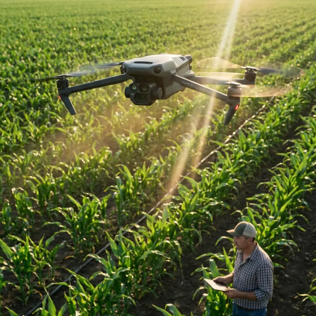
Mavic 3M Best Practices for Dusty Highway Scouting: A Field Tutorial Grounded in Endurance, Quiet Ops, and Clean Sensors
META: Practical Mavic 3M tutorial for dusty highway scouting, covering pre-flight cleaning, RTK discipline, multispectral workflow, and why endurance and low-noise operations matter in the field.
Highway scouting sounds straightforward until the environment starts fighting back.
Dust hangs over the shoulder. Passing trucks create pressure waves. Fine grit works into landing gear, camera glass, and vents. If your mission depends on the Mavic 3M capturing clean multispectral and RGB data over long roadside stretches, small habits matter more than most spec sheets admit.
This tutorial is built for that exact scenario: scouting highways in dusty conditions with the Mavic 3M, with an emphasis on practical field reliability. I also want to connect one broader industry signal that matters here. Recent reporting on hydrogen-powered UAV development highlighted a “three-in-one” value proposition: greener operation, lower noise, and longer endurance. That combination was presented as a meaningful path for low-altitude commercial aviation, especially because hydrogen platforms can offer more persistent energy supply than conventional fuel and battery-only drones.
Why bring that up in a Mavic 3M article? Because the same three operational priorities—quiet flight, efficient energy use, and enough endurance to finish useful work—shape how professionals actually deploy aircraft around roads, construction corridors, and infrastructure edges. The Mavic 3M is not a hydrogen drone, but if you understand why the industry is pushing toward green, silent, long-endurance aircraft, you make better decisions with the platform you have today.
Start with the real risk: dust does not just make the drone dirty
In highway scouting, dust is not cosmetic. It affects data quality and flight safety at the same time.
On the data side, a thin film on the optical surfaces can reduce contrast, soften edges, and compromise the consistency you want from multispectral capture. That matters when you are trying to compare vegetation stress along medians, assess roadside drainage patterns, or document disturbed soil across long corridors. In Mavic 3M work, multispectral value depends on clean, repeatable input. If the lens or sensor window is contaminated before takeoff, you are not collecting a trustworthy baseline.
On the flight side, dust can interfere with downward sensing, landing confidence, and overall pre-flight readiness. Even if the aircraft still flies normally, compromised vision or sensing surfaces can introduce unnecessary risk during launch and recovery on rough roadside ground.
That is why my first best practice is not glamorous:
Pre-flight cleaning is a safety step, not a housekeeping step
Before powering on, do a deliberate two-minute clean.
Focus on these areas:
- Camera and multispectral optical surfaces
- Downward sensing windows
- Airframe seams where dust accumulates
- Landing legs and contact points
- Battery contacts and compartment edges
- Propeller roots and motor tops
Use a soft air blower first. Then a clean lens-safe cloth for optical surfaces. Do not grind grit into the glass. If the aircraft rode in an open vehicle bed or was unpacked near active traffic, repeat the inspection after setup, not just back at the office.
This one habit directly supports the Mavic 3M’s strongest value: collecting consistent imagery you can trust. It also protects safety features that depend on clear sensing. In dusty highway work, I would rather lose two minutes on the ground than lose an hour re-flying contaminated data.
Build the mission around swath width, not battery optimism
One of the most common mistakes in corridor scouting is planning the route as if all battery minutes are equally usable. They are not.
Dusty roadside environments usually involve extra hover time during launch checks, occasional repositioning to avoid passing vehicles or temporary obstacles, and more cautious recovery procedures. So instead of drawing the longest possible corridor and hoping the battery margin holds, define the mission by workable swath width and data confidence.
For the Mavic 3M, that means deciding in advance:
- How wide a roadside strip actually needs to be captured
- Whether both pavement edge and vegetation shoulder must be in the same pass
- Whether a single altitude gives you the right ground detail for your objective
- How much overlap is needed for your mapping output, not for theoretical perfection
If your task is vegetation stress review along a highway edge, your swath width should support clean multispectral interpretation first. If your task is erosion or drainage mapping, then geometry and overlap may matter more than maximizing corridor length.
This is where the broader endurance discussion becomes operationally useful. The hydrogen UAV story emphasized longer-duration energy supply as a differentiator over both fuel and electric platforms. That detail matters because long linear assets like highways always expose the limits of endurance. For Mavic 3M teams working with battery-based aircraft, the lesson is simple: respect endurance constraints and segment work intelligently. Finish each segment with clean margins rather than chasing a single oversized mission.
Quiet operations matter more on highways than many crews realize
The same reference on hydrogen drones also highlighted low-noise flight. That is easy to dismiss until you work next to live traffic, roadside crews, inspectors, or agricultural edges intersecting transport corridors.
Lower acoustic disturbance has real operational significance:
- It reduces distraction for nearby civilian workers
- It makes verbal team communication easier during launch and recovery
- It draws less attention in mixed-use roadside environments
- It can improve stakeholder acceptance during repeated scouting work
Again, the point is not to confuse a Mavic 3M with a hydrogen aircraft. The point is to recognize that the future of low-altitude operations is being shaped by practical field demands, not abstract engineering goals. Green, quiet, long-endurance flight is attractive because it makes routine work more usable. For Mavic 3M operators, that means planning flights with the same discipline: minimize unnecessary hovering, avoid repeated low-altitude repositioning, and keep launch/recovery zones organized so the aircraft spends its time collecting data, not announcing itself.
RTK discipline: centimeter precision is only useful if you protect the fix
Highway scouting often tempts crews into rushing setup because the site feels linear and repetitive. That is exactly when RTK habits slip.
Centimeter precision is a major advantage when you need repeatable corridor mapping or want to compare site conditions over time. But precision on paper is not the same as stable field performance. Your RTK fix rate depends on site visibility, startup procedure, and patience during initialization.
In dusty highway environments:
- Set up clear of large vehicles and reflective surfaces where possible.
- Confirm your RTK status before launching the actual mapping leg.
- Do not assume a temporary fix is good enough for repeatable corridor work.
- If the fix quality is inconsistent, shorten the segment and preserve data integrity rather than gambling on a full run.
This matters operationally because highway scouting is often used for decisions that depend on exact position: drainage changes, shoulder deformation, encroaching vegetation, construction progress, or edge-of-road disturbances. If your geospatial confidence is weak, your beautifully stitched map can still become an argument instead of an answer.
Multispectral workflow: know what you are trying to prove
The Mavic 3M earns its place when the mission needs more than pretty imagery. On highway corridors, that usually means vegetation and surface condition interpretation.
Useful examples include:
- Stress detection in planted median vegetation
- Monitoring revegetation along disturbed embankments
- Identifying irrigation inconsistency near landscaped road sections
- Tracking spread of invasive growth near drainage routes
- Comparing recovery patterns after roadside earthwork
But multispectral only helps if the capture plan is built around a specific question. “Let’s collect multispectral while we’re here” is how teams generate folders, not insight.
Before takeoff, decide the outcome you need:
- Are you screening for anomalies?
- Establishing a baseline?
- Comparing against a previous survey?
- Supporting a maintenance recommendation?
That single decision drives altitude, overlap, timing, and revisit discipline. It also tells you whether dust contamination risk is acceptable. If you are collecting baseline data for later comparison, cleanliness standards should be stricter than in a one-off visual check.
Do not blur agricultural habits into corridor surveying without thinking
Many Mavic 3M operators also work around agriculture, so terms like spray drift and nozzle calibration naturally come up in adjacent workflows. Those are valid neighboring concerns, especially when a highway runs through active farm zones or when vegetation management planning overlaps with roadside maintenance.
But keep the mission boundaries clean.
If you are scouting a roadside strip, your job is to map conditions accurately, not to import assumptions from spraying operations. Spray drift may affect what you observe in roadside vegetation, and nozzle calibration may explain a pattern you later see in plant stress, but those factors are interpretation context, not flight-planning substitutes.
The practical takeaway: document what the Mavic 3M can verify. Record visible or multispectral evidence consistently. If you need field interpretation tied to treatment patterns, coordinate with the vegetation management team rather than guessing from the air.
A smart dusty-highway launch routine for Mavic 3M crews
Here is the field sequence I recommend.
1. Choose the cleanest realistic launch point
Avoid the obvious shoulder if every truck is throwing grit across it. Even a slightly offset gravel access area can reduce contamination during startup.
2. Clean before power-on
As noted earlier, treat this as a safety and data-quality step. Do optics first, then sensing areas, then prop and motor inspection.
3. Verify battery seating and contact cleanliness
Dust around contact surfaces is easy to miss. Check it every flight.
4. Confirm mission objective in one sentence
Example: “We are mapping vegetation stress along the eastbound median and shoulder for repeat comparison next month.”
If the team cannot say the mission simply, the capture plan usually is not ready.
5. Establish RTK confidence
Do not rush this step. A good fix rate is part of the mission, not a bonus feature.
6. Fly the first leg conservatively
Use the opening pass to validate visibility, traffic-related turbulence, and image confidence.
7. Reinspect before the second battery
Dust load after the first segment can be materially worse than at initial launch.
That final point is where many crews lose consistency. They trust the pre-flight clean, then forget that every low-altitude recovery near a busy road is effectively a new contamination event.
Why the green, low-noise, long-endurance trend should matter to Mavic 3M users today
The hydrogen UAV reference included two details with real significance for professional drone operators. First, it framed hydrogen power as a greener, lower-carbon route for the low-altitude economy. Second, it argued that hydrogen can provide more persistent energy supply than both conventional fuel UAVs and electric UAVs, while the headline stressed a trio of qualities: green, quiet, and long-endurance.
Those details matter even if your current fleet is all battery-based.
They point to what the market is rewarding:
- Aircraft that can stay productive longer
- Systems that create less disruption on the ground
- Operations that fit environmental and community expectations
For Mavic 3M users, this translates into practical habits right now:
- Plan fewer wasted sorties
- Reduce unnecessary hover time
- Keep missions tight and purposeful
- Protect data quality so every battery cycle produces usable output
- Treat quiet, efficient operation as part of professionalism
A drone does not need to be hydrogen-powered for those lessons to apply. In corridor scouting, efficiency is not just battery management. It is mission design, sensor care, launch discipline, and positional confidence working together.
One field note from experience: communication beats improvisation
Dusty highway work can get chaotic quickly. Trucks interrupt your timing. Wind shifts. The shoulder you planned to use becomes a bad recovery spot five minutes later.
When that happens, crews often start improvising in silence. That is when shortcuts creep in: no lens recheck, no RTK confirmation, rushed battery swaps.
Use a simple rule. Any change in launch point, mission leg, or return path gets spoken aloud and acknowledged by the team. If you need a second opinion on setting up a corridor workflow for your site conditions, it can help to message someone who understands Mavic mapping jobs in the real world rather than generic drone operation. One direct option is reach Marcus here on WhatsApp.
Final checklist for cleaner, more reliable Mavic 3M highway scouting
Before each sortie, confirm:
- Optics are clean
- Downward sensing surfaces are clear
- Props and motors are free of visible grit buildup
- Battery contacts are clean and secure
- RTK status is stable
- Mission objective is specific
- Swath width matches the real task
- Segment length respects battery margin
- Recovery zone is still usable under current traffic and dust conditions
The Mavic 3M is at its best when it is treated like a measurement tool, not a flying camera you happen to own. Dusty highway corridors punish lazy workflows. They also reward disciplined operators fast. Clean the aircraft properly. Protect your RTK fix rate. Capture multispectral data for a reason, not because the feature is there. And pay attention to where the broader UAV industry is heading: greener systems, lower noise, and longer practical endurance. Those are not abstract trends. They describe the conditions crews have been asking for all along.
Ready for your own Mavic 3M? Contact our team for expert consultation.