Mavic 3M at Altitude: A Field Report on Highway Scouting
Mavic 3M at Altitude: A Field Report on Highway Scouting When Conditions Refuse to Cooperate
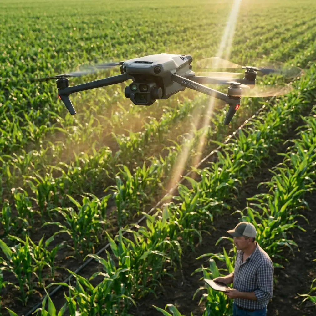
META: A field report on using the DJI Mavic 3M for high-altitude highway scouting, with practical insights on multispectral workflows, RTK precision, wind exposure, and why disciplined aerial data collection matters when attention is pulled elsewhere.
High-altitude highway scouting looks simple on paper. Stretch a corridor, fly repeatable lines, mark slope instability, drainage problems, encroaching vegetation, and heat-stressed surfaces, then move on to the next section. In practice, mountain weather compresses your schedule, light changes fast, and terrain turns line-of-sight planning into a chess match.
I learned that the hard way on a corridor survey where the brief sounded straightforward: evaluate highway shoulders, embankment vegetation, runoff patterns, and access points at elevation. We were working in thin air, with steep drop-offs, broken terrain, and a narrow weather window. The real challenge was not getting imagery. It was getting imagery you could trust.
That distinction is where the Mavic 3M earns its place.
This is not a generic drone story. It is a field story about what changes when the aircraft is asked to scout highways in high-altitude environments where every flight decision affects the quality of the map, the confidence of the maintenance team, and the number of return visits you can avoid.
The problem with “good enough” aerial scouting
Before using the Mavic 3M on this type of mission, our workflow depended too heavily on visual interpretation from standard RGB captures and manual ground notes. That worked well enough for broad overviews. It did not work well when we needed to separate genuinely stressed roadside vegetation from shadows, identify moisture-related patterns before a shoulder failure became visible to the naked eye, or compare one stretch of highway to another with consistent positional confidence.
At altitude, those weaknesses become obvious. Wind can distort your flight rhythm. Relief displacement is more noticeable in uneven terrain. Sun angles shift fast, especially in valleys and along mountain faces. If your positional data wanders, the value of repeat inspections drops quickly. You may still come back with a beautiful set of images, but beauty is not the same as utility.
The Mavic 3M changes that equation by combining multispectral capture with a workflow designed for disciplined repeatability. For highway scouting, that matters more than headline specs.
Why multispectral matters on a highway corridor
Many people associate the Mavic 3M primarily with agriculture. Fair enough. Its multispectral capability naturally fits crop health work. But in high-altitude highway scouting, that same capability becomes useful for a different reason: it helps you see living surface conditions in context with infrastructure stress.
Road corridors are ecological edges. Vegetation along slopes, culverts, ditches, shoulders, and retaining structures often tells you something before a visible failure develops. A healthy stand along one drainage path and a weak, inconsistent stand nearby can point to uneven water movement, compaction, runoff concentration, or disturbed subgrade conditions. In a mountain environment, those details are not cosmetic. They can affect erosion risk, maintenance scheduling, and crew deployment.
That is where multispectral data stops being a nice extra and starts becoming operationally relevant. It lets a survey team compare zones with more confidence than RGB alone. Instead of asking, “Does this patch look stressed?” you can ask, “Is this section behaving differently from adjacent sections, and is that difference spatially consistent over time?”
For highway authorities and engineering teams, this changes the conversation. The drone is no longer only documenting what is visible. It is helping prioritize where to inspect on foot.
Centimeter precision is not a luxury in mountain work
Another lesson from this kind of terrain: if your geospatial consistency slips, your reporting becomes harder to defend.
The Mavic 3M is often discussed in the same breath as centimeter precision and strong RTK performance, and that connection is warranted. On a highway corridor at altitude, a dependable RTK fix rate is not just a technical brag line. It directly affects whether your orthomosaic, inspection waypoints, and repeat missions line up cleanly enough to support trend analysis.
When crews revisit a mountain road after freeze-thaw cycles, rainfall, or slope stabilization work, they need to compare like with like. Small shifts in georeferencing can blur the story. A shoulder scar that looks wider may simply be misalignment. A drainage stain that appears to move may be a positioning issue rather than a field change.
This is why RTK-backed workflow discipline matters so much. With stronger positional confidence, the Mavic 3M becomes useful beyond one-off reconnaissance. It becomes a repeatable monitoring tool.
And that is the real threshold in professional UAV work: not whether a drone can fly the route once, but whether it can return weeks later and produce data that stands beside the earlier dataset without excuses.
High altitude punishes sloppy planning
The reader scenario here is highway scouting in high altitude, so let’s stay grounded in that reality. The aircraft is only one part of the outcome. Mission design matters just as much.
At elevation, wind exposure across ridge lines can vary dramatically within a single sortie. A clean launch area can give way to turbulent conditions over a cut slope. Battery planning becomes more conservative. Terrain awareness becomes non-negotiable. Light quality on one side of a highway can be radically different from the opposite side, especially if your corridor bends through changing topography.
With the Mavic 3M, one of the practical benefits is that the aircraft supports a more disciplined capture workflow for corridor tasks where repeatable line spacing, overlap, and route control actually matter. That discipline affects swath width decisions as well. Too ambitious a swath in mountainous terrain may save flight time while reducing interpretability along edges, embankments, and drainage structures. Too narrow, and you waste battery cycles and field hours.
The right balance depends on terrain relief, target resolution, and the specific maintenance questions you are trying to answer. That may sound obvious, but it is often where teams make expensive mistakes. They fly for broad coverage when the real need is edge-condition analysis.
A note on what this aircraft is not for
Because the source material in the news cycle is dominated by state-level drone shipments and geopolitical distraction, it is worth being explicit about boundaries. Recent reporting from the BBC noted that the United Kingdom plans its biggest-ever drone shipment to Ukraine, and quoted Defence Secretary John Healey saying, “Putin wants us to be distracted,” referring to the risk that global attention shifts toward events in the Middle East.
That detail has nothing to do with how a Mavic 3M should be evaluated for civilian field work. But it does reveal something broader about the drone sector right now: public attention is constantly pulled toward conflict narratives, while some of the most valuable drone applications remain quiet, local, and intensely practical.
Highway scouting is one of those applications.
When attention drifts toward dramatic headlines, infrastructure operators still need to inspect slopes, monitor drainage, and document corridor condition before seasonal damage multiplies. The operational significance is clear: distraction at the international level does not reduce the need for disciplined civilian drone work on the ground. If anything, it makes practical asset-management tools more valuable because they help understaffed teams focus on what actually needs intervention.
That contrast matters. It reminds us to judge aircraft like the Mavic 3M not by the volume of drone news, but by how well they solve hard commercial field problems.
The past challenge this aircraft made easier
On that earlier mountain corridor project, one recurring frustration was uncertainty around surface-adjacent vegetation stress. We could see color changes in RGB imagery, but not always interpret them reliably. Was a shoulder edge drying out because of seasonal exposure? Was a drainage line underperforming? Was disturbed vegetation signaling soil movement after maintenance activity, or was it simply a transient lighting effect?
With the Mavic 3M, the workflow became more decisive.
We could pair visible inspection with multispectral comparison and stop treating every suspicious patch as a separate mystery. Not every anomaly required a boots-on-ground visit. Some could be deprioritized quickly. Others moved to the top of the list because the pattern matched terrain, drainage, and corridor geometry in a way that deserved attention.
That is the hidden value of a better scouting platform. It does not replace engineering judgment. It sharpens it.
What operators coming from agricultural workflows should understand
Some of the LSI terms that follow this product around, like spray drift, nozzle calibration, and IPX6K, belong more naturally to agricultural drone conversations than to a Mavic 3M highway mission. Even so, they reveal an important point about operator mindset.
Teams crossing over from ag operations already understand environmental variability. They know that small shifts in wind, flight height, and overlap affect the reliability of the mission. They are accustomed to thinking in operational variables such as swath width and precision rather than just “getting footage.”
That mindset carries over beautifully into highway scouting.
No, nozzle calibration is not part of a Mavic 3M road inspection workflow. But the discipline behind calibration absolutely is. If your process for altitude, overlap, timing, and RTK verification is casual, your outputs will be casual too. In rugged corridors, there is little margin for that.
And while weather sealing discussions often focus on more demanding field equipment categories, the broader lesson remains: environmental resilience is not an abstract spec sheet topic when you are launching near exposed mountain roads where dust, moisture, and sudden weather shifts are routine concerns.
Where the Mavic 3M fits in a serious corridor program
For agencies, consultants, and infrastructure teams, the Mavic 3M is most useful when inserted into a structured program rather than treated as an occasional flying camera.
Used well, it supports:
- Baseline corridor mapping
- Repeat seasonal comparison
- Drainage and vegetation anomaly detection
- Slope and shoulder condition review
- Post-maintenance documentation
- Priority ranking for field inspections
That structure turns drone operations into a decision tool rather than a media exercise.
It also helps when collaborating across disciplines. Engineers want geospatial confidence. Environmental teams want condition indicators. Maintenance managers want practical prioritization. A well-flown Mavic 3M mission can speak to all three, especially when centroid-level or centimeter-level positional consistency supports follow-up work.
If your team is trying to build a repeatable workflow for mountain road assets and wants to compare notes on route planning or multispectral capture logic, this direct line is often the quickest way to start the conversation: message the field team here.
The real takeaway
The Mavic 3M is easy to misunderstand if you only see it through a single market lens. Yes, it is strongly associated with multispectral work. Yes, that naturally points many people toward agriculture first. But on high-altitude highway scouting jobs, that same platform solves a different set of problems: identifying subtle corridor condition signals, improving repeatability, and giving infrastructure teams a more defensible basis for deciding where to send people next.
That is why this aircraft stood out for us in mountain work.
It reduced ambiguity. It improved the quality of repeat inspections. It made the mission less about chasing images and more about collecting evidence.
And in a moment when the broader drone conversation is often dominated by geopolitical headlines like the UK’s biggest-ever drone shipment and warnings that public attention can be diverted by other crises, there is something refreshing about a tool that proves its value in quieter ways. A mountain road does not care what is trending in the news. If the drainage is failing, if the shoulder is weakening, if the slope vegetation is signaling stress, the problem is already underway.
The best field technology helps you see that early and act with confidence.
That is where the Mavic 3M belongs.
Ready for your own Mavic 3M? Contact our team for expert consultation.