Mavic 3M in Forest Terrain: A Field Tutorial on Control
Mavic 3M in Forest Terrain: A Field Tutorial on Control Discipline, Multispectral Reliability, and RTK Stability
META: Learn how to use Mavic 3M for forest scouting in complex terrain, with practical guidance on speed control, RTK stability, electromagnetic interference mitigation, and multispectral workflow discipline.
Forest work exposes every weakness in a drone operation.
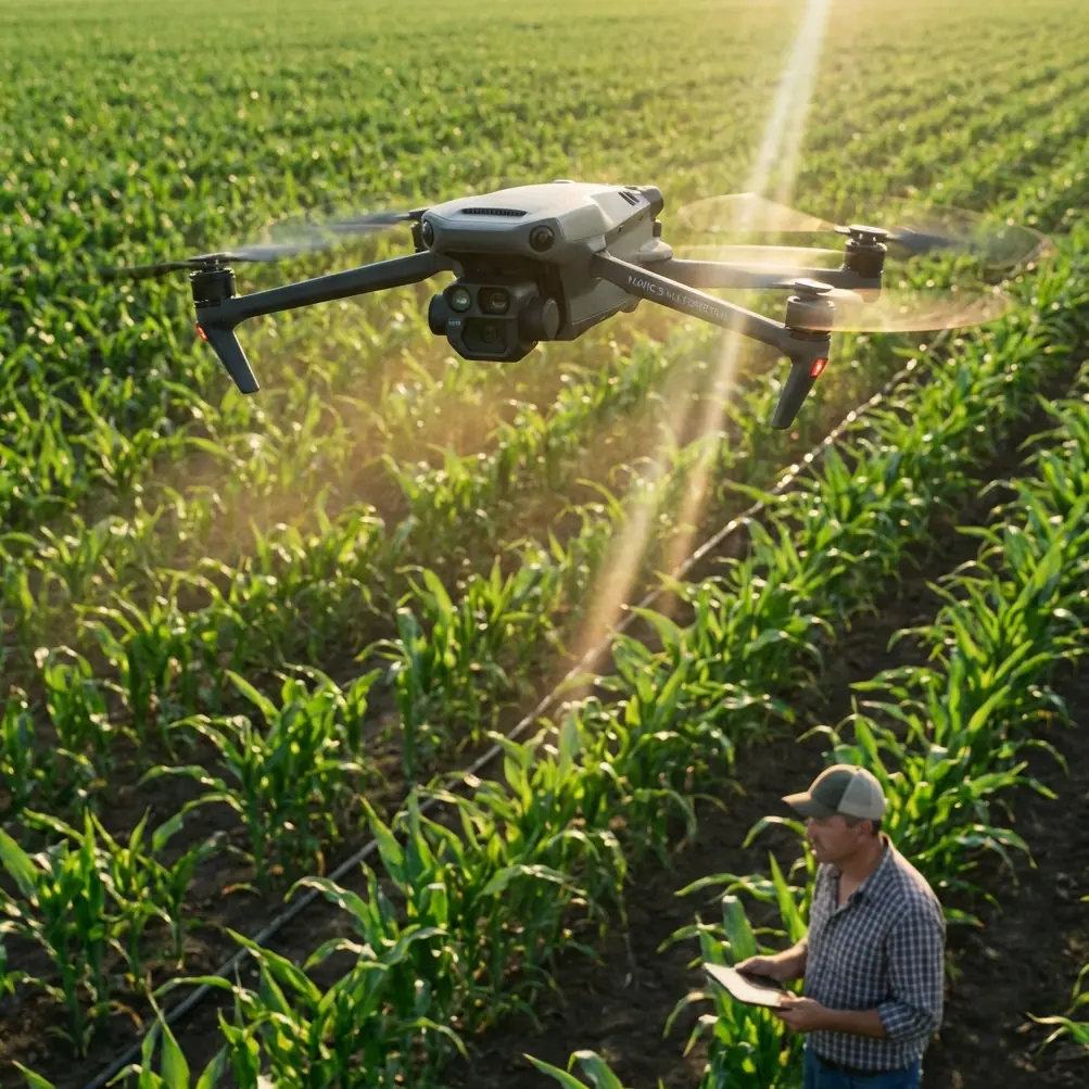
Open farmland is forgiving. Forest edges are not. Once you move into mixed canopy, broken relief, ravines, wet ground, and irregular electromagnetic conditions, the Mavic 3M stops being a simple mapping tool and starts acting like what it really is: a precision aircraft carrying a sensitive remote-sensing payload. That distinction matters.
For teams scouting forests with the Mavic 3M, the question is rarely whether the aircraft can collect useful data. It can. The real issue is whether the operator can preserve data quality while managing the small flight-control errors that compound fast in cluttered terrain. That is where disciplined handling, speed selection, and signal management make the difference between a clean multispectral dataset and a map that looks complete but cannot be trusted.
This tutorial is built around a simple idea: control quality drives data quality.
Why forest scouting is harder than many Mavic 3M users expect
The Mavic 3M is often discussed in agricultural terms, but forest scouting presents a different operational profile. In woodland corridors, the aircraft may transition between open sky and partial canopy shadows in seconds. Slopes distort visual perception. Tree lines create uneven wind loading. Moisture and vegetation can affect signal behavior. And if you are trying to maintain centimeter precision with RTK while preserving consistent overlap and stable multispectral capture, those environmental shifts matter more than most first-time users assume.
In a forest survey, the aircraft is not just flying a route. It is maintaining a measurement standard.
That means you need to think beyond mission automation. You need to understand what stable forward motion, speed consistency, antenna orientation, and pre-turn setup do for the final product. A forest manager reviewing vigor zones, canopy stress, drainage impacts, access routes, or replanting blocks does not care whether the drone “completed the mission.” They care whether the resulting map supports a decision.
The overlooked lesson from training drones: speed is not a background setting
One of the more useful training references in drone education is surprisingly basic: a programming example for an educational DJI TT platform that sets movement speed through a speed module. The range in that example is 20 to 100 centimeters per second, and if no speed module is inserted, the aircraft uses a default 50 centimeters per second. The training sequence itself is simple: hover, wait 3 seconds, rotate 180°, then move forward 60 centimeters at 30 centimeters per second, and land.
That sounds far removed from a Mavic 3M over a forest block. It is not.
The operational significance is this: flight behavior changes immediately when speed is treated as a deliberate variable instead of a passive default. In educational programming, every motion command after the speed command inherits that speed until changed again. In professional fieldwork, the same mindset helps prevent a common mistake—letting the mission plan dictate speed everywhere, even where terrain and signal conditions demand adjustment.
In forest scouting, speed affects at least four things at once:
- Image consistency across a variable background
- Turn accuracy near tree lines and elevation breaks
- RTK fix stability, especially where geometry and interference fluctuate
- Pilot recovery margin if a route needs manual intervention
A slower flight is not always better. Too slow can expose the aircraft to prolonged turbulence near canopy edges and can make manual corrections feel exaggerated. Too fast can reduce your comfort margin when the terrain compresses your line of sight or when you need to verify a stable RTK state before crossing into a complex section. The useful lesson from that training document is not the literal 20–100 cm/s range. It is that speed must be assigned intentionally.
For Mavic 3M forest missions, treat speed as part of the sensing strategy, not just the transport setting.
Before every critical maneuver, re-establish “level flight” in a mapping sense
A second reference, drawn from technical model-aircraft training, emphasizes something experienced pilots recognize immediately: before a demanding maneuver, the aircraft should first be stabilized in level flight. The source warns that operators often enter a maneuver while unconsciously climbing, which bleeds speed and makes the aircraft more likely to drop or drift unpredictably. It also notes a practical truth: as speed increases, the maneuver becomes easier and less affected by gravity-induced drop.
This was written for aerobatic roll training, not survey drones. Yet the principle transfers extremely well to Mavic 3M forest work.
In mapping terms, “level flight before the maneuver” means this:
- Do not enter a turn, terrain-following transition, or narrow corridor section while still correcting the previous segment.
- Do not allow a subtle climb just before a turn point near a tree line.
- Do not assume the autopilot has fully settled after a disturbance just because the aircraft is generally on course.
That matters because forest scouting missions often fail quietly. The drone remains airborne and returns home safely, but the data quality degrades in the exact places where you need confidence most: canopy gaps, slope transitions, riparian strips, disease pockets, and regeneration edges.
The training text makes another point with direct operational value: if the aircraft cannot maintain the same height at the end of a movement sequence, speed and power management likely need adjustment. Translate that into Mavic 3M practice and you get a rule worth following:
If your aircraft exits a turn or terrain transition with visible attitude correction, do not assume the next imaging run is clean.
Pause. Reset. Rebuild a stable track.
That small delay is often cheaper than discovering later that one critical strip has inconsistent overlap or uneven capture geometry.
Electromagnetic interference in forests: antenna discipline is not optional
The context here specifically calls for handling electromagnetic interference through antenna adjustment, and this is exactly the kind of practical detail that gets ignored until a mission goes wrong.
Forests are not free from interference. In fact, some of the most troublesome sites sit near ridge communications equipment, buried utility corridors, fire-watch infrastructure, rural relay points, roads, power lines, or temporary field stations. Add moisture, terrain shielding, and awkward pilot positioning, and link quality can become inconsistent even when the area looks remote.
When flying the Mavic 3M in these conditions, antenna management should be active, not passive.
What to do in the field
1. Face the aircraft’s working sector, not just its launch point.
If the mission extends along a valley wall or around a forested bend, reposition yourself so the controller antennas maintain the best possible geometry to the aircraft’s active route segment.
2. Adjust antenna angle before signal degradation becomes obvious.
Do not wait for repeated warnings. If video transmission begins to fluctuate when the aircraft skirts a slope or tree mass, refine antenna alignment immediately.
3. Avoid body shielding.
Operators often hold the controller low or turn their torso while watching terrain. That can partially block the link path. Keep the controller high enough and pointed deliberately.
4. Use route segmentation.
If one block includes known interference, split the job into smaller missions launched from better positions. The extra setup time usually pays back in stronger RTK fix rate and cleaner image capture.
5. Watch for “false confidence” in open gaps.
A signal may recover in a clearing, then drop again as the aircraft crosses behind a denser stand or ridge shoulder. Judge link health over the full route, not just one open patch.
This matters for more than aircraft control. A stable communications environment supports better mission continuity, more predictable telemetry, and fewer abrupt corrections. For multispectral work, continuity is crucial. Forest analytics often depend on relative consistency from strip to strip, not merely on whether each image is individually sharp.
If your team regularly encounters difficult terrain and wants a practical workflow discussion around antenna positioning and field setup, this direct Mavic 3M operations chat is a useful next step.
RTK fix rate in complex terrain: the hidden backbone of forest mapping
Forest scouting tends to magnify positional error because the terrain itself is visually complex. When you are evaluating stand boundaries, canopy thinning, access roads, erosion patterns, or storm damage, geometry matters. That is why RTK behavior deserves more attention than it often gets in routine flights.
The goal is not just “RTK available.” The goal is consistent RTK performance throughout the route.
In practical terms, that means:
- Verifying fix quality before entering the most obstructed sector
- Watching whether fix state degrades near slopes or dense vertical obstruction
- Avoiding unnecessary high-dynamic corrections that may stress route smoothness
- Restarting a segment if fix stability was compromised during the most critical pass
Centimeter precision is especially valuable when you need repeatable comparison over time. A forestry team may fly the same block after storm impact, disease treatment, thinning, drainage work, or replanting. If positional consistency drifts, your comparisons become less reliable, especially around narrow features and edge zones.
The Mavic 3M earns its place in this work when the operator protects that precision rather than assuming the system will protect itself.
Multispectral over forests: why steady motion beats aggressive coverage
The Mavic 3M’s multispectral capability is often framed around vegetation analysis, but forests challenge interpretation more than uniform crops do. A field crop gives you comparatively clean geometry and homogeneous spacing. A forest canopy gives you layered structure, shadow variation, mixed species reflectance, and uneven crown shapes.
This is where flight smoothness becomes an analytical issue.
A rushed mission can still produce a visually impressive orthomosaic, yet the multispectral consistency may be weaker across problematic sections. In forest scouting, that can distort how you interpret stress signatures, regeneration vigor, water influence, or pest spread. If you are reviewing subtle gradients rather than obvious damage, stable acquisition is worth more than squeezing the largest swath width out of every battery.
That also affects how you think about route design. Near canopy breaks or steep terrain, a conservative approach often wins:
- keep lateral spacing disciplined
- avoid abrupt speed changes mid-line
- rebuild stable track after each turn
- maintain enough altitude margin to reduce local turbulence effects without sacrificing the resolution your task needs
The point is not to fly timidly. The point is to fly predictably.
What forest teams should borrow from beginner training—and what they should ignore
Professional operators sometimes dismiss beginner drone education and model-flight instruction because the aircraft class is different. That is a mistake.
The educational TT example teaches that movement speed is a governed parameter, not a vague feel. The aerobatic training text teaches that stable entry conditions determine stable outcomes. Both ideas are directly useful for Mavic 3M forestry operations.
What should you borrow?
- Explicit speed planning rather than one-size-fits-all routing
- Stable pre-maneuver setup before turns and transitions
- Respect for energy management, especially where terrain creates hidden drag and downdraft effects
- Recognition that small control errors cascade
What should you ignore?
- Any assumption that aircraft automation removes the need for pilot discipline
- Any habit of trusting route completion as proof of data quality
- Any tendency to interpret interference warnings as purely a radio problem rather than an operational positioning problem
A practical forest mission template for the Mavic 3M
If I were briefing a team for a complex-terrain forest scouting day, I would use a workflow like this:
1. Define the analytical objective first
Are you scouting for stand health, drainage stress, storm damage, access-path planning, or replanting verification? Your answer affects altitude, overlap, speed, and revisit strategy.
2. Walk the launch geometry
Check ridges, towers, power infrastructure, roads, and likely signal shadows. Decide where antenna orientation will be strongest for the critical legs.
3. Build route segments instead of one oversized mission
Forest blocks often look contiguous on a map but behave differently in the air. Break them up according to terrain and signal logic.
4. Set a deliberate speed strategy
The lesson from the TT training reference applies here: choose speed consciously. Do not let a default planning value govern every section equally.
5. Confirm RTK health before entering the hardest area
Do this at the moment it matters, not just at launch.
6. Fly each turn like it affects the map
Because it does. A poor exit from a turn can contaminate the next line more than operators realize.
7. Watch the aircraft, not only the screen
Small attitude corrections, drift behavior, and hesitation around transition points often tell you more than map progress indicators.
8. Re-fly suspect strips immediately
Do not save uncertainty for desktop review if conditions still allow a clean repeat.
The real skill in Mavic 3M forest scouting
The best Mavic 3M forestry operators are not necessarily the ones with the most dramatic workflows or the most software layers. They are the ones who preserve consistency under imperfect conditions.
That means understanding that a speed setting is a measurement choice. That a subtle climb before a turn can reduce control margin. That a poor antenna angle can snowball into unstable link behavior exactly where terrain is least forgiving. That centimeter precision is valuable only when the full mission preserves it. And that multispectral data is only as good as the flight discipline behind it.
The reference details here may seem humble: 20 to 100 cm/s in an educational speed module, 50 cm/s as a default movement value, a 180° rotation followed by 60 cm of forward travel at 30 cm/s, and a training warning that entering a maneuver without stable, level flight often leads to height loss and directional inconsistency. Yet these are not trivial facts. They point to a deeper operational truth.
Precision flying is built from controlled transitions.
For forest scouting with the Mavic 3M, that is the habit worth developing. Not flying faster. Not flying farther. Flying in a way that protects the meaning of the data.
Ready for your own Mavic 3M? Contact our team for expert consultation.