Mavic 3M in Winter Forest Recon: What Actually Matters When
Mavic 3M in Winter Forest Recon: What Actually Matters When Conditions Turn Hostile
META: A field-based Mavic 3M case study for forest scouting in extreme temperatures, covering multispectral workflow, RTK stability, electromagnetic interference, and practical flight discipline.
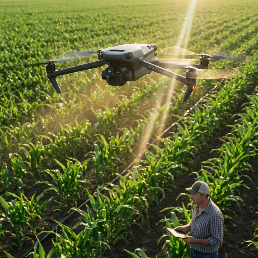
I spent part of last season reviewing a forest scouting program that looked straightforward on paper and unruly in the air. The aircraft was the Mavic 3M, the mission profile was vegetation assessment across mixed woodland, and the environmental challenge was twofold: extreme temperatures and unstable signal conditions near utility corridors and metal-rich infrastructure at the forest edge. The team wanted clean multispectral data. What they got at first was a lesson in how fast small technical weaknesses can turn into mapping drift, uneven coverage, and unnecessary re-flights.
That is the real story with the Mavic 3M in forest work. Not whether it can collect multispectral imagery. It can. The harder question is whether it can do so repeatably when cold air, canopy structure, and electromagnetic interference begin working against your assumptions.
This case study focuses on that point.
Why forest scouting is a harsher test than open-field agronomy
Many operators first understand the Mavic 3M through row-crop agriculture. The logic makes sense: broad visibility, regular geometry, easy line planning, and clear expectations around swath width and overlap. Forest reconnaissance is different. The canopy is vertically layered. Shadows persist. Moisture pockets vary by slope and elevation. Wind can be negligible at takeoff and messy above the treeline. If you are operating in winter or at temperature extremes, battery behavior and sensor stability become more consequential with every sortie.
That is where operational discipline outranks marketing claims.
The Mavic 3M earns its place in forestry because multispectral collection can reveal vegetative stress patterns that are difficult to detect in standard RGB alone. But in woodland environments, the value of that data depends on consistency. Slight shifts in flight behavior, speed control, or positioning confidence can ripple through the entire dataset.
The team I observed learned this early. Their first problem was not image quality in the obvious sense. It was repeatability under interference.
The interference problem no one should treat as a footnote
The forest block sat adjacent to infrastructure that introduced intermittent electromagnetic noise. Nothing dramatic enough to stop all operations. Just enough to degrade confidence in link behavior and create anxiety about whether the aircraft was maintaining the cleanest possible navigation and data capture path.
This is where antenna adjustment stopped being a minor pilot habit and became mission-critical.
Operators sometimes treat antenna positioning as a box to tick before takeoff. In forest scouting, especially near interference sources, that is careless. We found that deliberate antenna alignment, matched to the aircraft’s working sector rather than simply pointed “in the general direction,” improved control stability and reduced the tendency to overcorrect when signal quality fluctuated. The practical significance is simple: fewer pilot-induced micro-adjustments means a steadier mission profile, and a steadier mission profile protects overlap consistency and geospatial reliability.
That matters because the Mavic 3M is not just taking pictures. It is building a measurable surface of information. If the aircraft is constantly being nudged, your downstream analysis can suffer in ways that are not obvious until stitching, classification, or vegetation comparison begins.
In this program, changing antenna orientation protocol became part of the checklist whenever the aircraft approached the corridor edge. It sounds mundane. It saved time.
Extreme temperatures expose weak preflight habits
Cold weather tends to punish teams that rely on habits formed in mild conditions. Batteries are the obvious concern, but not the only one. The aircraft’s mechanical and electronic behavior must remain predictable from startup through climb and into stable cruise.
One of the more useful technical references I often think about in this context comes from BLHeli revision documentation, even though it is not a Mavic 3M flight manual. Revision 12.0 introduced a programmable main spoolup time and specifically changed startup behavior so the motor is stopped before starting. It also limited power at very low RPMs to avoid sync loss when back electromotive force is low. In plain operational language, that tells us something larger than firmware trivia: startup smoothness and low-speed control are not cosmetic issues. They are central to reliability when systems are stressed.
For forest missions in extreme temperatures, that principle carries over directly. A cold-soaked aircraft should never be rushed from power-on to tasking as if startup behavior is irrelevant. Let the system settle. Watch for abnormal hesitation. Listen for any inconsistency in rotor response. If a control system designer considers low-RPM sync protection important enough to revise at firmware level, field teams should treat stable spin-up and orderly takeoff as part of data quality assurance, not merely aircraft safety.
The same BLHeli revision history also notes improved running smoothness and quieter damped light behavior at both low and high RPMs. Again, the significance for us is broader than ESC internals. Smooth propulsion response reduces transient vibration and unnecessary attitude correction. In multispectral work, especially over textured canopy, anything that stabilizes the platform helps preserve mission consistency.
The RTK question in dense-edge forest operations
The phrase “centimeter precision” gets used too casually. Under forest-edge conditions, what matters is not the slogan but the RTK fix rate you can actually sustain across the mission area.
The team’s first few runs showed a pattern I see often: excellent confidence in open launch zones, then degraded stability as terrain and canopy geometry changed. The temptation was to blame the site as inherently unsuitable. That was only partly true. The real issue was mission design.
They had planned routes as if the forest block were a homogeneous target. It was not. Certain sections produced weaker positional confidence because of line-of-sight complications and reflected signal behavior. Once the route was segmented into smaller zones, with attention to entry angle, antenna discipline, and altitude transitions, the usable RTK performance improved enough to make the outputs operationally dependable.
That is the lesson. Do not ask whether the Mavic 3M has RTK capability in the abstract. Ask where the fix degrades, how often, and what route architecture gives you the best chance of preserving it. A high RTK fix rate is not just a specification to admire. It governs how much confidence you can place in change detection, boundary comparisons, and repeat surveys through the season.
For forestry teams tracking regeneration, stress spread, or stand variability, that difference is enormous.
Multispectral data is only as good as the mission geometry
When readers ask me for “tips,” they often expect settings. I usually start with geometry instead.
Swath width is not merely an efficiency variable. In forests, it is a data integrity variable. Push coverage too wide, especially under uneven light and canopy texture, and you risk weakening consistency at the margins of each pass. That can make spectral interpretation less reliable, particularly if you plan to compare flights over time. Narrowing the mission envelope slightly and accepting a longer flight sequence often produces cleaner analysis than chasing maximum area per sortie.
The team revised three things:
- They reduced effective mission width in the most interference-prone section.
- They increased overlap beyond what would have been acceptable in open-field crop work.
- They adjusted flight timing to avoid the hardest shadow transitions.
Those changes were not dramatic. They transformed the output.
The Mavic 3M is at its best when the operator respects the difference between collecting imagery and collecting comparable imagery. In forest scouting, that distinction is everything.
Why an education document still says something useful here
One of the reference documents in this brief is an educational DJI text that includes sections on investigating drone fall data and on formation flight, with page references around Chapter 3 and a note on “无人机编队播种” on page 69. At first glance, that seems unrelated to a single Mavic 3M scouting mission in the woods. It is not.
The operational significance is methodological. Training frameworks that examine fall data teach teams to study failure as evidence, not embarrassment. Formation exercises, even in educational settings, train spacing discipline, positional awareness, and route obedience. Those same habits transfer directly to forest scouting: clean lane management, predictable transitions, conservative obstacle respect, and disciplined reaction to disturbances.
In our case, the strongest pilot was not the one with the fastest hands. It was the one who flew like a trained surveyor. Calm path control. No vanity corrections. No improvisation when the plan was adequate. That mindset prevented small disturbances from becoming bad data.
So even a seemingly unrelated training manual contributes something valuable: it reminds us that advanced missions are rarely won by hardware alone. They are won by trained behavior.
A note on spray drift and nozzle calibration—even when you are not spraying
The contextual hints here include spray drift and nozzle calibration, which belong more naturally to agricultural application than forest scouting. Yet the concepts still help frame Mavic 3M planning.
Spray drift is, at heart, a lesson in how environmental conditions distort intended distribution. In scouting, the analogue is data drift: wind, shadows, temperature gradients, and interference all nudge the mission away from ideal consistency. Nozzle calibration is about making sure the output matches the plan. In Mavic 3M work, your “calibration” is route design, sensor workflow, overlap strategy, and preflight validation.
That analogy helps teams coming from spraying operations adapt more quickly to multispectral reconnaissance. The aircraft may be doing a different job, but the discipline is familiar: control the variables you can, measure the ones you cannot fully control, and never assume the environment is passive.
Building a repeatable cold-weather workflow
After several sorties, the team settled into a forest-specific routine that worked well:
- Warm batteries and stage takeoff only when the aircraft is ready for immediate departure.
- Pause after power-on to observe system normality rather than rushing launch.
- Check antenna orientation before every line segment near interference sources.
- Divide the site into mission blocks based on signal behavior, not just acreage.
- Use conservative swath planning where canopy texture and shadowing are worst.
- Monitor RTK confidence as an operational variable, not a background status icon.
- Keep pilot inputs minimal during automated capture segments.
- Debrief every anomaly, even if the sortie appears successful.
That final point matters. Some of the most expensive forestry mistakes are not crashes. They are “successful” flights that quietly create uncertain data.
If your team is trying to standardize Mavic 3M forest operations, I strongly recommend creating a short field note template for every mission. Record ambient temperature, interference zones, antenna adjustments that helped, any RTK drop pattern, and whether the overlap or altitude plan should change next time. A simple running log can become more valuable than any glossy operations sheet.
If you want a direct field discussion on setup logic, one practical option is to message our technical team on WhatsApp and compare your site constraints before the next deployment.
What this means for Mavic 3M users in real forest conditions
The current drone industry conversation is full of delivery headlines. One recent example came from the UK, where Amazon completed its first parcel deliveries by drone and said expansion would happen gradually as demand for ultra-fast delivery grows. That measured rollout is worth paying attention to. Not because parcel delivery and forest scouting are the same mission. They are not. The useful parallel is operational maturity.
Serious drone programs do not scale all at once. They expand carefully because real-world conditions expose edge cases: signal irregularities, temperature effects, route design flaws, startup behavior, and training gaps. Forest Mavic 3M missions deserve the same mindset. Move gradually. Learn from each block. Build procedures around observed reality, not brochure assumptions.
That is exactly what happened in this case study. Once the team stopped treating the forest like a standard mapping site and started treating it like a complex environment with its own failure modes, the aircraft performed the way it should have from the beginning.
The Mavic 3M proved highly capable. But capability was only half the equation. The other half was a workflow built around environmental respect: deliberate antenna adjustment in electromagnetic noise, careful attention to startup behavior in cold conditions, and route design that protected RTK stability and multispectral consistency.
Those are not glamorous lessons. They are the ones that keep your data usable.
Ready for your own Mavic 3M? Contact our team for expert consultation.