Mavic 3M Forest Scouting in Extreme Temperatures
Mavic 3M Forest Scouting in Extreme Temperatures: What China’s Drone Training Crackdown Means for Real-World Operators
META: China’s drone training sector fell from 4,200 to 2,703 providers in three months after new rules took effect, with direct implications for Mavic 3M forest scouting, pilot quality, RTK reliability, and cold-weather field safety.
Forest scouting with the DJI Mavic 3M has never been just a question of hardware. In difficult terrain and temperature extremes, the aircraft is only one part of the operating system. The other part is the pilot, and that is exactly where the latest training shakeout in China becomes relevant.
A recent industry report points to a sharp contraction in the drone training market: the number of UAV training institutions reportedly dropped from more than 4,200 at the end of last year to 2,703 by March 2026. That means over 1,400 organizations disappeared in roughly three months. The trigger was the formal implementation, at the end of 2025, of the 《民用中小型无人驾驶航空器操控员训练机构规范》, a new standard governing civil training institutions for small and medium unmanned aircraft operators.
At first glance, that may sound far removed from a Mavic 3M mission over cold forest blocks, mountain plantations, or heat-stressed woodland corridors. It is not. For operators using a multispectral platform to detect canopy stress, map regeneration, or compare vegetation vigor across large tracts, weak training creates bad data long before it creates a visible accident.
Why this policy shift matters to Mavic 3M users
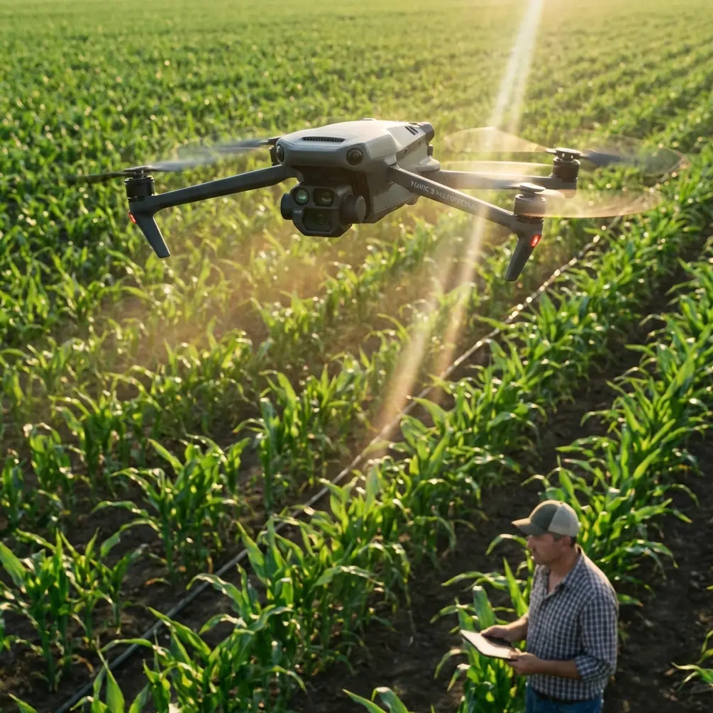
The Mavic 3M sits in a special place in the field workflow. It is compact enough to deploy quickly, but sophisticated enough to produce multispectral outputs that influence land management decisions. In forestry, those decisions can include replanting priorities, pest surveillance, stand uniformity checks, and access planning after weather events. When the aircraft is flown in extreme cold or heat, the operational margin narrows. Pilot skill stops being a nice bonus and becomes the difference between clean data and expensive noise.
That is why the reduction from 4,200-plus training providers to 2,703 is more than industry gossip. It suggests the market is being forced away from low-standard instruction and toward formal compliance. For Mavic 3M operators, that matters because multispectral missions are less forgiving than basic visual flights. A forest scouting sortie often requires repeatable altitude control, stable overlaps, correct swath width planning, consistent antenna orientation, and reliable RTK Fix rate if the output must align with previous surveys at centimeter precision.
A pilot who learned from a weak training pipeline may know how to launch and land. That is not enough. In real forestry operations, the challenge is not simply keeping the aircraft in the air. It is maintaining data integrity across environmental stress.
The hidden risk in extreme-temperature scouting
Forests create their own flight problems. Dense canopy reduces visual references. Sloped terrain distorts apparent altitude. Moisture, frost, haze, and thermal shimmer all interfere with flight judgment and sensor consistency. Temperature extremes amplify every one of those variables.
In cold conditions, battery behavior changes, takeoff decisions become less forgiving, and the aircraft may take longer to stabilize. In high heat, electronics, pilot concentration, and mission pacing all come under pressure. These are not abstract concerns for a Mavic 3M team collecting multispectral data. If your line spacing is slightly off, if your speed varies too much, or if your return path is improvised because the pilot misread terrain, your mosaic quality suffers and your comparison datasets become harder to trust.
This is where the regulatory crackdown becomes operationally significant. A stronger training standard should, in theory, eliminate institutions that treated pilot certification as a formality. The report specifically ties the market contraction to a late-2025 rule that raised the threshold for training providers. That kind of filtering matters because forest scouting is one of the worst environments in which to discover that a pilot never properly learned mission discipline.
With the Mavic 3M, good forestry data depends on repeatability. Repeatability depends on method. Method depends on training.
Multispectral data quality rises or falls on field habits
The Mavic 3M’s multispectral capability is the reason many forestry teams choose it in the first place. It can reveal subtle differences in vegetation condition that a standard RGB image may miss. But the aircraft does not automatically turn every flight into a usable vegetation analysis dataset.
For example, swath width planning is often treated as a software setting when it is really an operational decision. In forests with uneven topography, the pilot has to understand how altitude variation changes effective coverage and overlap. A rushed operator may widen the mission pattern to save time, then discover gaps or weak edge quality that compromise interpretation. A properly trained operator thinks differently: terrain first, repeatability second, speed third.
The same principle applies to RTK-supported work. If you are comparing forest health over time, centimeter precision becomes valuable because it reduces ambiguity between one survey and the next. That only helps if the pilot knows how to protect RTK Fix rate during setup and flight execution. Poor launch positioning, interference, weak sky visibility, or sloppy mission preparation can reduce positional confidence even when the aircraft itself is capable.
This is why better training institutions matter. The pruning of more than 1,400 organizations in a single quarter suggests that regulators are forcing a distinction between “can issue a certificate” and “can prepare an operator for real conditions.” For a Mavic 3M user flying forestry missions in harsh weather, that distinction has practical consequences in every stitched map and every prescription-level interpretation.
Antenna positioning advice for maximum range in forest operations
One field mistake deserves special attention because it is common, preventable, and directly relevant to range stability: antenna positioning.
In wooded environments, signal behavior is rarely ideal. Trunks, moisture-heavy canopy, terrain breaks, and launch-site choices all work against clean communication. If you want maximum practical range and more stable control in forest scouting, do not point the ends of the controller antennas directly at the aircraft. Position the flat faces of the antennas toward the Mavic 3M’s likely flight path, and choose a launch point with the clearest possible line of sight above nearby brush or vehicles. Small changes in body position matter too; if your torso or vehicle blocks the controller, signal quality can degrade faster than many pilots expect.
This sounds basic, but it becomes crucial in cold and hot weather. In extreme cold, you do not want to waste battery reserve on unnecessary signal recovery maneuvers. In heat, long troubleshooting pauses expose both aircraft and crew to extra strain. Good antenna discipline is one of those habits that better training should reinforce early, because it protects both control quality and mission consistency.
If your team is building a forest scouting workflow and wants a practical second opinion on deployment habits, this field support channel is a useful starting point: message a UAV specialist here.
What stricter training means for forestry teams, not just schools
The headline around the training collapse is that tuition may rise as institutions disappear and compliance costs increase. That is easy to understand. Harder, and more important, is what this means downstream for organizations deploying aircraft like the Mavic 3M.
A smaller training market can improve operator quality if the surviving institutions deliver stronger instruction in planning, airspace awareness, emergency handling, data collection logic, and maintenance discipline. For forestry teams, this could translate into fewer avoidable field failures and more trustworthy survey products. It may also reduce the number of newly certified pilots who arrive with impressive paperwork but weak judgment.
That matters because forest scouting work often moves beyond simple observation. A team may use Mavic 3M outputs to identify stressed zones, prioritize ground checks, or coordinate follow-up operations with larger UAV platforms. In mixed fleets, understanding neighboring concepts such as spray drift, nozzle calibration, and mission geometry is not irrelevant, even if the Mavic 3M itself is not the spraying aircraft. A forestry operator who identifies problem zones with multispectral data may hand that map to another team responsible for targeted treatment. If the scouting data is poorly captured, every downstream decision becomes less efficient.
This is where the current industry reset may do some good. It raises the baseline expectation that UAV work is a profession with technical consequences, not a casual side business.
The real problem is not access to drones. It is access to competent operation.
The Mavic 3M remains attractive because it lowers the logistical barrier to collecting serious data. It packs quickly, deploys fast, and can cover meaningful acreage without requiring a large field crew. But convenience can create a false sense of simplicity. In forestry, especially under temperature stress, the mission is only easy when conditions are benign and the objective is vague. Most professional missions are neither.
The recent contraction in training institutions should be read as a warning label for buyers and operators alike. If over 1,400 providers exited within about three months after the new rules landed, the implication is hard to avoid: a large portion of the market was not built to meet a tougher professional standard. That should change how organizations evaluate pilot qualifications.
For Mavic 3M scouting, ask harder questions. Has the pilot been trained to maintain repeatable mission geometry across sloped terrain? Do they understand how environmental conditions affect RTK behavior and image consistency? Can they explain how antenna orientation influences control reliability in forest corridors? Do they know when a mission should be postponed because the data quality risk is higher than the value of same-day collection?
Those are the questions that separate acceptable flying from dependable forest intelligence.
A practical way to adapt
If you are responsible for forestry surveys, the answer is not to wait for the market to stabilize. It is to tighten your own standard now.
Start with mission design. In extreme temperatures, reduce unnecessary complexity and preserve power margin. Confirm launch locations that improve line of sight. Review antenna position before takeoff, not after signal warnings appear. Treat multispectral data capture as a repeatability exercise, not a sightseeing flight. If RTK support is part of your workflow, monitor fix quality with the same seriousness you give battery levels.
Then look at pilot development. A certificate acquired in a turbulent training market should not be the only proof of readiness. Require field demonstrations. Review past datasets. Ask for examples of how the pilot handled temperature stress, terrain interference, and signal management in wooded environments.
The training crackdown in China is ultimately a story about standards. For Mavic 3M users, especially those scouting forests in punishing weather, standards are not bureaucracy. They are the framework that protects your data from avoidable errors.
The aircraft is capable. The question is whether the operating culture around it is catching up.
Ready for your own Mavic 3M? Contact our team for expert consultation.