Scouting Fields with Mavic 3M in Extreme Temperatures
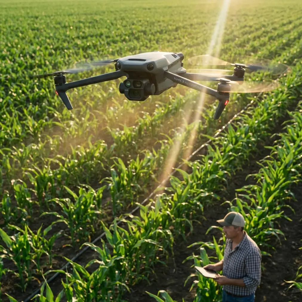
Scouting Fields with Mavic 3M in Extreme Temperatures: What Actually Matters
META: A field-tested Mavic 3M case study on scouting crops in extreme temperatures, with practical insight on multispectral workflow, redundancy thinking, obstacle sensing limits, and safer mission planning.
The hardest agricultural drone days are rarely the dramatic ones. Not storms. Not equipment failures. It’s the long, punishing temperature swings that expose every weak link in your workflow.
A few seasons ago, I was helping a grower team scout large blocks during a week that started with a cold sunrise and ended in harsh midday heat. The aircraft wasn’t the only thing under pressure. Batteries behaved differently across flights. Visual conditions kept changing. Field edges hid obstacles that looked obvious from the ground but became deceptively easy to misjudge from the air. We were collecting crop health data, but half the battle was simply maintaining consistency.
That experience changed how I evaluate aircraft for field scouting. With the Mavic 3M, the question is not just whether it can capture multispectral data. Plenty of buyers start there. The real question is whether it can produce repeatable, trustworthy field intelligence when temperatures are working against the operator, the batteries, and the sensors.
That is where operational discipline matters more than spec-sheet enthusiasm.
Why extreme temperatures make scouting harder than most people admit
When readers talk about field scouting in heat or cold, they usually jump straight to battery life. Fair concern, but it’s only one layer.
Temperature extremes affect:
- launch timing and mission windows
- sensor consistency
- pilot decision-making
- obstacle awareness near tree lines, wires, and structures
- how reliably you can maintain a clean mapping pattern across multiple sorties
For a platform like the Mavic 3M, which is often used to produce agronomic maps rather than simply capture pretty aerial photos, the standard is higher. If the mission output is supposed to inform irrigation checks, stand assessment, drainage investigation, early stress detection, or follow-up spray planning, then small inconsistencies become expensive. A bad map is not neutral. It can send a farm team in the wrong direction.
That is why I keep coming back to two ideas drawn from the reference material: redundancy and sensor limitations.
They sound technical. In practice, they are field management issues.
The first lesson: redundancy is not a luxury mindset
One of the most useful reference points here comes from the DJI TT education material, which explains why reliable aircraft often use dual backup design on critical components such as batteries, IMU, barometric altitude systems, and signal transmission. It even gives a plain-language analogy: a heavy truck may be able to operate with one tire in a position, but carries another as redundancy because failure tolerance matters.
That logic applies directly to agricultural scouting.
When you send a Mavic 3M over hundreds of acres in difficult temperatures, you are not asking for casual performance. You are asking for mission continuity. If one subsystem misbehaves, the aircraft must still preserve enough stability and control integrity to protect the mission and the surrounding environment.
The operational significance is simple: redundancy thinking reduces the chance that a single point issue turns into a failed sortie, lost dataset, or unsafe recovery.
Even more relevant is another detail from the same source: dual-signal transmission between ESC and flight control can preserve control instruction flow if the primary control signal is lost, while the system monitors sensor status in real time and switches when needed. That matters in field conditions where interference, terrain variation, and long repetitive flight lines can stress communication reliability.
For Mavic 3M operators, this becomes a practical takeaway. Don’t just ask whether the drone flies well. Ask whether your whole workflow is built to tolerate partial failure.
That means:
- rotating batteries conservatively in heat and cold
- confirming RTK status before each mission segment
- splitting large jobs into manageable blocks
- validating data in the field instead of discovering gaps back at the office
- planning recovery zones before launch, not after a warning appears
The strongest operators I know don’t assume a smooth mission. They build one that can absorb problems.
The second lesson: obstacle sensing is never the whole safety plan
The same educational source includes a detail that deserves more attention in agriculture than it usually gets. It notes that a forward-facing TOF ranging sensor mounted higher on the aircraft may fail to “see” an obstacle positioned below the sensor but still at propeller height. In that scenario, the aircraft can still be blocked even though the sensor geometry creates a blind spot.
This sounds like an edge case until you’ve flown near orchards, trellis systems, pump assemblies, irrigation risers, shelterbelts, or uneven field-edge infrastructure.
In scouting work, especially early-morning or late-day missions with long shadows, the hazard is not always a large object directly in front of the drone. Sometimes it is a structure whose position relative to the sensing hardware creates a bad assumption. Operators who rely too heavily on obstacle avoidance can get caught out.
That has direct significance for the Mavic 3M in extreme temperature field scouting because temperature stress often pushes teams to move faster. They want to launch early, beat heat, finish blocks, and move on. That is exactly when lazy assumptions creep in.
The field rule I teach is blunt: obstacle sensing is support, not permission.
If you are mapping with the Mavic 3M along field boundaries, drainage channels, windbreaks, or near equipment yards, maintain route discipline. Build buffer zones. Use clean approach and exit paths. Don’t force the aircraft into awkward low-level transitions just because the software suggests the line is possible.
The source goes one step further and says that neither obstacle avoidance systems nor redundancy systems can fully eliminate the danger of a drone falling. That is not pessimism. That is mature aviation logic. It applies just as much to civilian ag scouting as to any broader airworthiness discussion.
What eVTOL safety discussions can teach Mavic 3M operators
At first glance, the Chengdu eVTOL test flight and operations seminar seems far removed from a compact agricultural mapping drone. It isn’t.
The core theme of that event was how eVTOL can enter real operational environments safely. Not in theory. In actual service.
That same mindset should shape how we use the Mavic 3M.
Agricultural teams sometimes treat small drones as if low weight automatically means low consequence. But once a drone becomes part of crop decision-making, agronomy scheduling, and field logistics, it enters the same larger conversation: how do we move from technical capability to safe routine operation?
That requires more than learning buttons and menus.
It requires:
- standard launch checks
- mission design suited to environmental conditions
- clear go/no-go criteria
- attention to human factors
- realistic understanding of what automation can and cannot cover
This is where the Mavic 3M stands out when used correctly. Its value is not just that it captures multispectral imagery. Its value is that it can fit into a repeatable scouting process where data quality and operational reliability reinforce each other.
That is the bridge between drone ownership and actual farm utility.
A real-world Mavic 3M workflow for extreme temperatures
Here is the framework I now recommend after seeing too many teams treat field scouting as a race.
1. Build the mission around the thermal window, not the calendar window
If temperatures are extreme, your best flight time may be much narrower than your workday. For crop scouting, consistency matters more than squeezing in one extra block. The Mavic 3M’s multispectral output is only as useful as the conditions under which it was collected.
I would rather see a team finish fewer acres cleanly than capture a larger dataset with inconsistent conditions and questionable comparability.
2. Confirm RTK behavior before the field pattern begins
The context around the Mavic 3M points toward readers who care about RTK fix rate and centimeter precision. Good. You should. If you’re mapping fields to compare stress signatures, drainage patterns, emergence differences, or replant zones, positional consistency is not academic.
Check that the aircraft settles into a stable fixed solution before relying on the mission output. In practical terms, that improves repeatability across flights and helps preserve alignment integrity when you revisit the same area under different temperature conditions.
3. Leave more edge margin than you think you need
This is where that TOF sensor geometry lesson pays off. A field map does not become more valuable because you shaved the route tighter to the obstacle line. Tree rows, utility poles, irrigation gear, and partial-height obstructions can create ugly surprises.
A smart operator accepts a little extra buffer and keeps the aircraft in cleaner airspace.
4. Treat battery rotation as part of data quality
Extreme cold and extreme heat both change how batteries behave in the field. Don’t run your scouting plan as though every pack is interchangeable across the entire day. Track flight order, temperature exposure, and turnaround time. Keep batteries within sensible operating discipline before launch and during swaps.
A clean, repeatable power strategy is one of the least glamorous ways to improve Mavic 3M mission reliability. It also happens to work.
5. Verify the agronomic objective before launch
This may sound obvious, but I still see teams fly “because the drone is here” rather than because the mission answers a specific question. Are you checking spray drift symptoms? Looking for irrigation non-uniformity? Comparing stand vigor? Identifying where nozzle calibration issues may have translated into uneven field response? Evaluating swath width effects after field operations?
The Mavic 3M becomes far more useful when the flight plan is tied to a decision pathway.
The hidden mistake: flying perfect lines for the wrong purpose
The aerobatic training reference may seem unrelated, but one lesson from it translates surprisingly well. The text explains that when a maneuver starts correctly but the aircraft later drifts off line, the root issue may be energy management and control timing rather than the pilot’s original intent. In one example, if the turning radius is too large, speed bleeds off at the top, and the aircraft destabilizes during the next phase.
For Mavic 3M operators, the equivalent mistake is becoming obsessed with a visually neat mission while ignoring the conditions that make the output meaningful.
I have watched teams execute elegant automated grids in weather or thermal conditions that made the data far less usable than they assumed. The aircraft flew correctly. The mission design did not.
That is why I tell operators to focus less on “did the route run” and more on “did this route produce decision-grade information.”
The same training principle applies: your control choices determine the outcome.
Why the Mavic 3M made my own field scouting easier
What changed for me with the Mavic 3M was not just image capture. It was the reduction in friction between planning and action.
When temperature windows are tight, a good aircraft needs to help you move from setup to usable agronomic interpretation with fewer compromises. The Mavic 3M fits that role well because it supports a practical multispectral scouting workflow without dragging the team into a heavy-lift operational burden.
That matters more than many buyers realize.
If I’m helping a farm manager evaluate crop variability after a difficult weather swing, I need speed, repeatability, and enough positional confidence to revisit the same zone later. I also need to avoid overtrusting the aircraft’s protections. The references above reinforce both sides of that equation: better reliability through layered system design, and persistent limits in obstacle sensing and overall safety.
That combination is what mature drone operations look like.
Not hype. Not blind faith in automation. Just disciplined use of a capable tool.
Where Mavic 3M fits in a smarter agriculture stack
For readers scouting fields in extreme temperatures, the Mavic 3M is best understood as an information aircraft, not a general-purpose flying camera.
Used properly, it helps teams:
- identify stress earlier with multispectral context
- revisit zones with stronger positional consistency
- reduce wasted ground inspection time
- support follow-up actions tied to application quality, irrigation issues, or stand differences
- document conditions across a season without turning every survey into a major operation
The caveat is just as important as the upside. The aircraft does not remove the need for airspace judgment, route margin, or environmental discipline. Sensor systems can miss certain obstacle geometries. Redundancy improves reliability, but redundancy itself has limits and can introduce its own risk considerations. That is straight out of the reference material, and it is exactly the kind of realism the ag drone sector needs more of.
If you’re building a Mavic 3M workflow for serious field scouting, especially in heat or cold, that realism will serve you better than any marketing summary.
And if you want to compare notes on field setup, RTK workflow, or how to structure a scouting routine around extreme weather windows, you can message our ag drone team here.
The best Mavic 3M operators I know are not the ones who fly the most acres in a day. They are the ones who come back with data the farm can actually trust.
Ready for your own Mavic 3M? Contact our team for expert consultation.