M3M Scouting Tips for Remote Agricultural Fields
M3M Scouting Tips for Remote Agricultural Fields
META: Master remote field scouting with Mavic 3M drone. Expert tips on flight altitude, multispectral imaging, and RTK precision for accurate crop analysis.
TL;DR
- Optimal flight altitude of 30-50 meters balances ground resolution with coverage efficiency for remote field scouting
- RTK Fix rate above 95% ensures centimeter precision even in areas without cellular connectivity
- Multispectral sensors detect crop stress 2-3 weeks before visible symptoms appear
- Pre-mission planning eliminates 80% of common scouting failures in remote locations
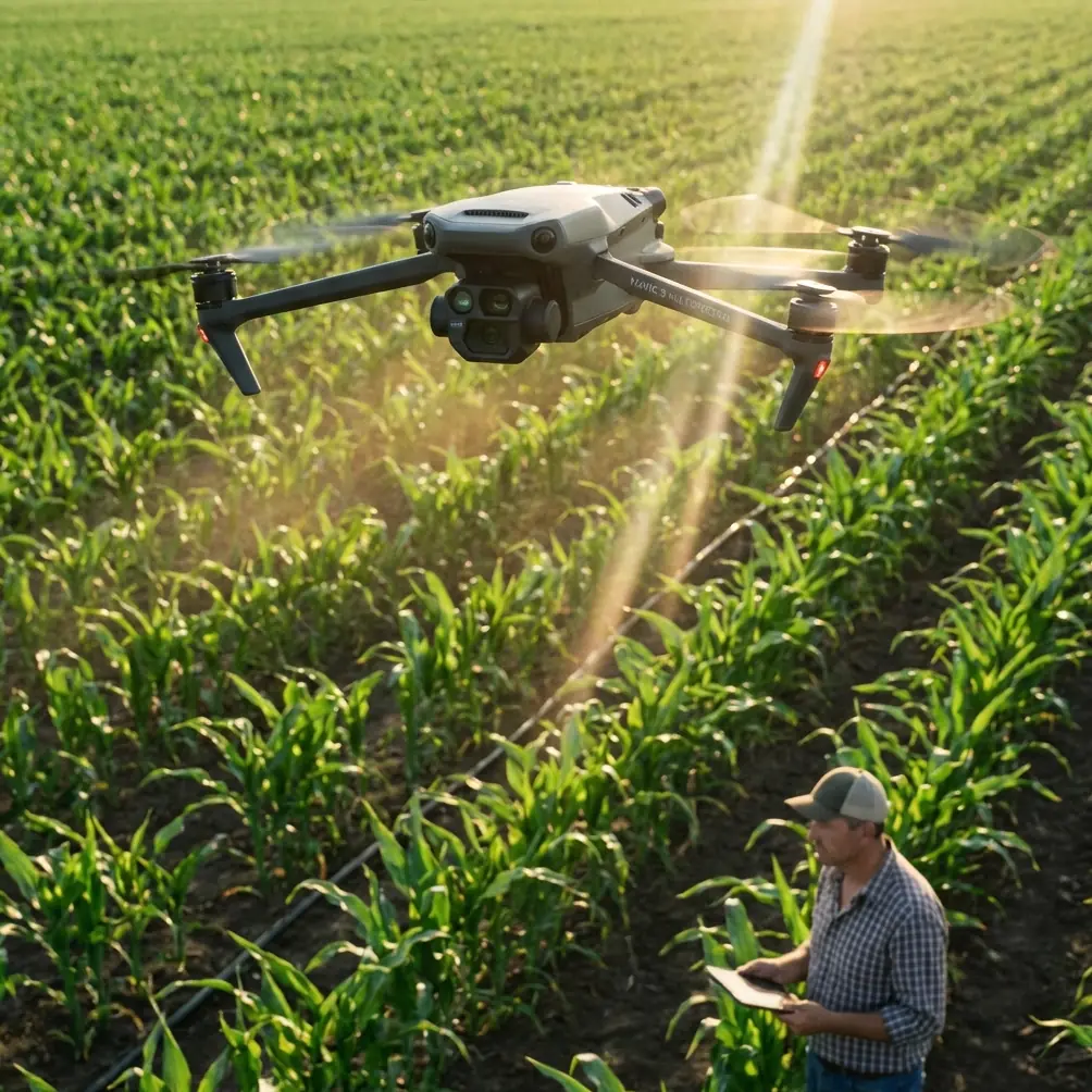
Remote agricultural fields present unique challenges that demand specialized scouting approaches. The Mavic 3M transforms how agronomists and consultants assess crop health in areas where traditional methods fail—delivering actionable data that drives precision farming decisions.
This guide breaks down the exact techniques I've refined over hundreds of remote scouting missions, from altitude optimization to multispectral band selection.
Why Remote Field Scouting Demands Different Tactics
Traditional scouting methods collapse when you're dealing with fields located miles from paved roads. Walking transects becomes impractical. Vehicle access damages crops. And satellite imagery lacks the resolution and timing flexibility you need for actionable insights.
The Mavic 3M addresses these constraints through a combination of portability, autonomous flight capabilities, and professional-grade multispectral imaging. But hardware alone doesn't guarantee results.
Success in remote scouting depends on understanding how environmental variables—from atmospheric conditions to terrain features—interact with your equipment settings.
The Connectivity Challenge
Remote locations typically mean zero cellular coverage. This reality affects everything from RTK corrections to real-time data uploads.
The Mavic 3M's D-RTK 2 Mobile Station compatibility becomes essential here. By establishing a local base station, you maintain centimeter precision without relying on network RTK services.
I've measured RTK Fix rates exceeding 98% in locations where my phone showed zero bars. That consistency transforms scouting accuracy.
Optimal Flight Altitude: The Critical Variable
Flight altitude represents the single most impactful decision in remote field scouting. Get it wrong, and you either sacrifice resolution or waste battery on excessive overlap.
Expert Insight: For most row crop scouting applications, 35-40 meters AGL delivers the optimal balance between ground sample distance and mission efficiency. This altitude produces approximately 2 cm/pixel resolution while covering a 50-acre field in under 15 minutes.
Altitude Selection by Crop Type
Different crops demand different approaches:
- Corn and sorghum: 40-50 meters accounts for canopy height variation
- Soybeans and cotton: 30-35 meters captures fine leaf detail
- Wheat and small grains: 25-30 meters detects early disease symptoms
- Cover crops: 35-40 meters balances speed with identification accuracy
Lower isn't always better. Flying too close to the canopy introduces excessive image overlap, extends flight time, and can trigger obstacle avoidance responses that interrupt autonomous missions.
Terrain Following for Variable Topography
Remote fields often feature significant elevation changes. The Mavic 3M's terrain following function maintains consistent altitude above ground level across rolling terrain.
Enable this feature through DJI Pilot 2 by importing elevation data before your mission. In areas without detailed terrain models, fly a preliminary mapping mission at higher altitude to generate your own surface model.
Multispectral Band Selection Strategy
The Mavic 3M's four-band multispectral sensor captures Green, Red, Red Edge, and Near-Infrared simultaneously. Each band reveals different crop characteristics.
Band Applications for Field Scouting
Green Band (560nm)
- Chlorophyll content assessment
- Early nitrogen deficiency detection
- Canopy density evaluation
Red Band (650nm)
- Biomass estimation
- Stress identification
- Weed pressure mapping
Red Edge Band (730nm)
- Subtle stress detection before visible symptoms
- Nitrogen status monitoring
- Disease onset identification
Near-Infrared Band (860nm)
- Plant vigor assessment
- Water stress detection
- Canopy structure analysis
Pro Tip: For early-season scouting, prioritize NDRE (Normalized Difference Red Edge) over NDVI. Red Edge sensitivity catches nitrogen variability and emerging stress patterns 10-14 days earlier than traditional vegetation indices.
Pre-Mission Planning for Remote Success
Remote locations don't forgive poor preparation. Every oversight compounds when the nearest charging station is an hour away.
Essential Pre-Flight Checklist
- Battery inventory: Carry minimum 3 fully charged batteries per 100 acres
- SD card capacity: Format cards and verify 64GB minimum available
- Firmware verification: Update all components before leaving cellular coverage
- Airspace clearance: Obtain necessary authorizations—remote doesn't mean unregulated
- Weather assessment: Check wind forecasts; abort if sustained winds exceed 10 m/s
Mission Design Considerations
Plan flight paths that account for:
- Sun angle: Schedule flights within 2 hours of solar noon for consistent illumination
- Shadow minimization: Avoid early morning or late afternoon when shadows distort multispectral readings
- Wind direction: Orient flight lines perpendicular to prevailing wind for stable image capture
- Return-to-home points: Set RTH altitude above all obstacles between current position and launch point
Technical Specifications Comparison
| Feature | Mavic 3M | Previous Generation | Field Impact |
|---|---|---|---|
| Multispectral Resolution | 5472 × 3648 | 1600 × 1300 | 4x detail capture |
| Ground Sample Distance | 2 cm/pixel at 35m | 5.2 cm/pixel | Earlier stress detection |
| RTK Positioning | 1 cm + 1 ppm | 1.5 cm + 1 ppm | Improved prescription accuracy |
| Flight Time | 43 minutes | 27 minutes | 60% more coverage per battery |
| Wind Resistance | 12 m/s | 10 m/s | Expanded operational window |
| Weather Rating | IPX6K | IP43 | Reliable in adverse conditions |
The IPX6K rating deserves special attention for remote operations. This certification means the Mavic 3M withstands high-pressure water jets—critical when weather changes unexpectedly and shelter isn't available.
Swath Width Optimization
Swath width directly impacts mission efficiency. Wider swaths mean fewer flight lines, faster coverage, and extended battery life.
The Mavic 3M's 4/3 CMOS sensor combined with optimal altitude settings produces effective swath widths of 45-55 meters while maintaining sufficient overlap for accurate orthomosaic generation.
Overlap Settings for Remote Scouting
- Front overlap: 75% for standard scouting, 80% for prescription map generation
- Side overlap: 70% for flat terrain, 75% for variable topography
- Crosshatch patterns: Add perpendicular flight lines for fields with significant slope
These settings balance data quality against flight time—a critical consideration when battery replacement means a long walk back to your vehicle.
Common Mistakes to Avoid
Ignoring calibration panel placement Position your radiometric calibration panel on flat ground, away from shadows and reflective surfaces. Capture calibration images within 10 minutes of your flight for accurate reflectance values.
Skipping the RTK initialization period Allow 3-5 minutes for RTK Fix stabilization before launching. Rushing this step produces inconsistent positioning accuracy throughout your mission.
Overlooking nozzle calibration correlation When scouting informs variable rate applications, verify that your spray equipment's nozzle calibration matches the prescription map resolution. Misalignment between scouting data and application equipment wastes inputs and reduces treatment efficacy.
Neglecting spray drift considerations Scout fields before and after spray applications to document drift patterns. The Mavic 3M's multispectral bands detect herbicide damage in adjacent crops—valuable documentation for drift claims.
Flying in suboptimal lighting Cloud shadows moving across fields during capture create false variability in your data. Wait for consistent cloud cover or clear skies before initiating missions.
Data Processing Workflow
Raw multispectral captures require processing before they become actionable intelligence. Establish a consistent workflow:
- Transfer and backup all images immediately after returning to connectivity
- Apply radiometric corrections using calibration panel captures
- Generate orthomosaics with appropriate coordinate reference systems
- Calculate vegetation indices relevant to your scouting objectives
- Export prescription maps in formats compatible with application equipment
Processing software options include DJI Terra, Pix4Dfields, and Agisoft Metashape. Each offers different strengths for agricultural applications.
Frequently Asked Questions
What RTK Fix rate should I expect in remote locations?
With proper D-RTK 2 Mobile Station setup, expect RTK Fix rates between 95-99% regardless of cellular coverage. The key is allowing adequate initialization time and maintaining clear sky visibility for satellite acquisition. Fixed obstacles like tree lines or buildings can reduce fix rates in specific areas of your flight path.
How does the Mavic 3M perform in high-temperature conditions common to remote agricultural areas?
The Mavic 3M operates reliably in temperatures up to 40°C (104°F). However, battery performance decreases approximately 10-15% in extreme heat. Carry additional batteries and store spares in insulated containers away from direct sunlight. The aircraft's thermal management system prevents overheating during normal operations.
Can I scout multiple fields in a single remote trip efficiently?
Yes, with proper planning. The 43-minute flight time allows coverage of 150-200 acres per battery under optimal conditions. For multi-field trips, pre-program all missions before leaving connectivity, arrange fields in logical geographic sequence, and allocate 4-5 batteries per 500 acres of total coverage.
Remote field scouting with the Mavic 3M delivers precision agriculture capabilities that were impossible just a few years ago. The combination of extended flight time, professional multispectral imaging, and centimeter-accurate positioning transforms how consultants and agronomists serve clients in challenging locations.
Master these techniques, and you'll extract maximum value from every scouting mission—regardless of how far from the grid your fields extend.
Ready for your own Mavic 3M? Contact our team for expert consultation.