Mavic 3M in Windy Vineyards: What Actually Improved Our
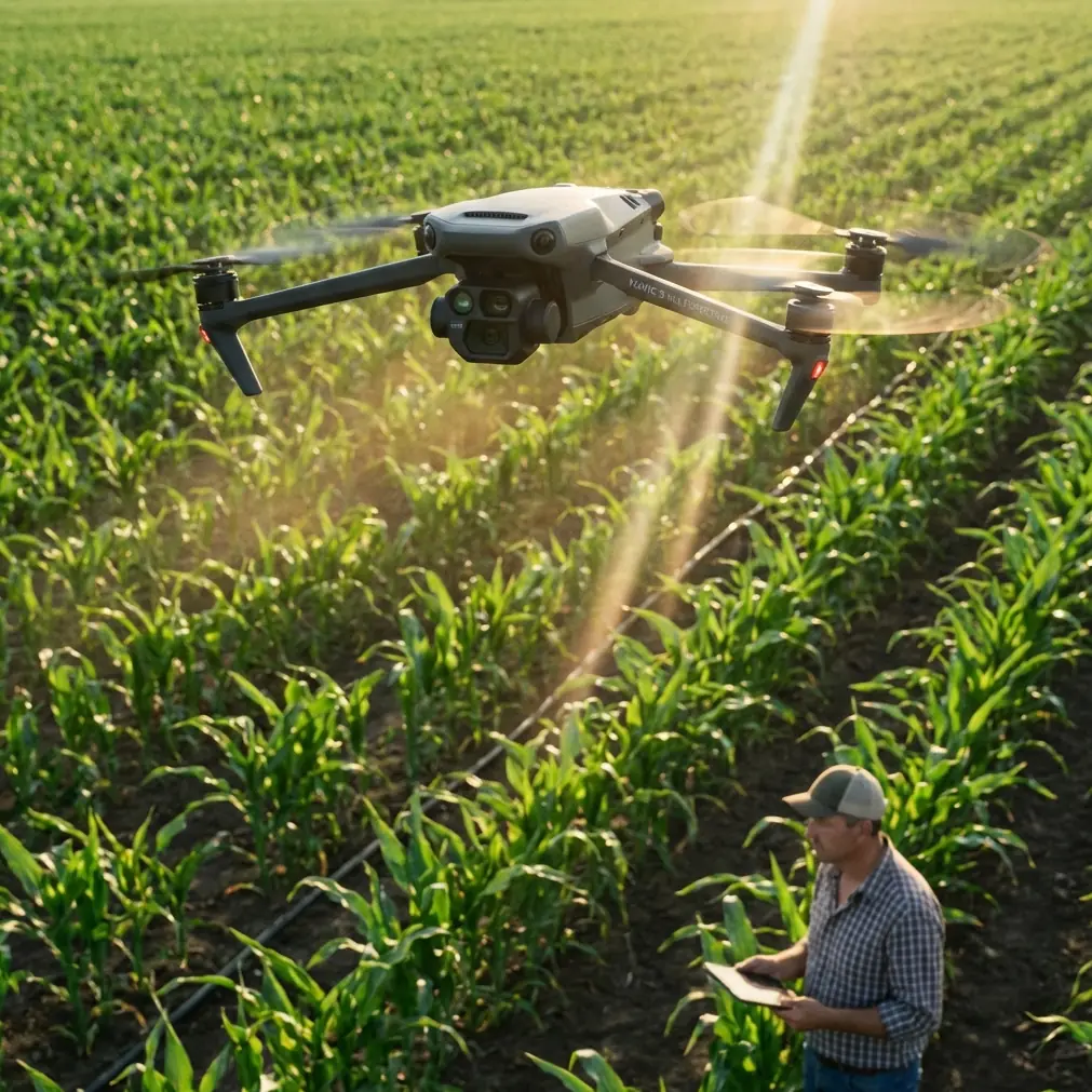
Mavic 3M in Windy Vineyards: What Actually Improved Our Monitoring Results
META: A field-based case study on using Mavic 3M for vineyard monitoring in windy conditions, with practical lessons on stability, multispectral consistency, flight behavior, and precision operations.
Wind exposes weak habits faster than almost anything else in vineyard drone work.
That was the real lesson from one of our early multispectral monitoring runs over a coastal vineyard block. The aircraft was capable. The mission plan looked clean. The grower wanted a reliable read on vine vigor variation before making decisions tied to irrigation timing and spray planning. Yet the outputs kept showing small inconsistencies from row to row. Not disastrous. Just enough to undermine confidence.
People often blame the sensor first. Or the platform. Or the weather itself. In this case, the problem was subtler: stability discipline.
That idea may sound surprisingly basic for a discussion about the Mavic 3M, a professional tool built for precision agriculture and mapping workflows. But basic is where repeatability lives. A recent piece about smartphone photography made a useful point: two people can use the same camera, yet one gets cleaner, more balanced images because a simple grid setting helps prevent tilted framing and unstable-looking shots. The camera hardware did not change. The operator’s visual reference did.
The same principle matters in the field with the Mavic 3M, especially when monitoring vineyards in windy conditions. Stable data begins with stable orientation. Not just stable hover performance, but stable thinking about line discipline, yaw control, roll response, and how the aircraft tracks across rows when crosswinds try to pull it off the mission path.
That is where this aircraft became much easier to trust.
The vineyard problem wind creates
Vineyards are not broad, uniform commodity fields. They are narrow patterns of repeated structure. Rows, gaps, canopies, missing vines, slope transitions, end rows, access tracks. In multispectral work, that geometry matters. When you are trying to compare vigor across adjacent rows or isolate weak zones, small alignment errors become operationally significant.
In calm air, a mapping workflow can hide sloppy pilot instincts. In wind, it cannot.
The issue is not only whether the drone stays in the sky. The real issue is whether it preserves enough positional and attitude consistency to give you clean, comparable imagery. If one pass is slightly skewed by yaw drift and the next pass is slightly rolled by lateral correction, your final vegetation analysis can still process, but interpretation becomes less trustworthy. In a vineyard, where row orientation strongly shapes the visual pattern, that trust gap matters.
With the Mavic 3M, what improved our confidence was not a single headline feature. It was how the aircraft’s precision-oriented workflow reduced the accumulation of small errors.
Why flight mechanics still matter to Mavic 3M operators
A lot of newer users treat agricultural imaging as mostly a software exercise. Plan mission, fly mission, export layers, interpret indices. That skips over the most physical part of the job: how a quadcopter fights to maintain direction and position.
A technical training document on quadcopter motion explains this well. Lateral movement is not magic. When the flight controller reduces speed on the motors on one side and increases speed on the other side, the aircraft tilts and moves laterally. If that motor speed difference stays within a controlled range, the drone translates sideways. If the difference becomes too large, the aircraft can exceed a 90-degree tilt and effectively roll over. In normal operations, of course, you never want to approach anything close to that. But the principle matters.
In vineyard wind, every correction has a consequence. A gust from the side pushes the aircraft off line. The system responds through controlled roll. That roll changes how the platform presents itself relative to the rows and the ground below. A good aircraft and a well-tuned mission can keep those corrections small and recover quickly. A poor setup, or a pilot who ignores wind direction relative to row orientation, can create repeated side-load corrections across the whole block.
This is one reason the Mavic 3M works better when the operator thinks like both a pilot and an agronomist. The agronomist wants a usable plant-health map. The pilot needs to understand how the platform’s motion affects data consistency.
Yaw discipline is the hidden quality factor
There is another mechanical detail that rarely gets enough attention in drone agriculture: yaw.
The same training source describes quadcopter yaw as the result of changing diagonal rotor speeds while keeping total lift constant. For example, if one diagonal pair increases rotational speed and the opposite pair decreases speed, the aircraft experiences counter-torque and rotates. The key point is that yaw correction is achieved without simply climbing or dropping. It is a rotational balancing act.
Why does that matter in a windy vineyard?
Because many row-based monitoring tasks punish even slight directional inconsistency. If the aircraft’s heading wanders as it tracks a corridor between rows, your imagery may still georeference, but the visual pattern can become less uniform. This is especially noticeable when you compare repeated flights over time. For disease scouting, irrigation evaluation, or canopy variability checks, repeatability beats raw visual drama every time.
With the Mavic 3M, the operational win was maintaining heading discipline well enough that repeated passes over vine rows produced imagery that looked intentionally acquired, not merely captured. That sounds like a small distinction. It is not. In agricultural decision-making, “intentionally acquired” data is data a farm manager will use.
A simple composition lesson that translates to drone operations
The smartphone grid-line analogy is more relevant here than it first appears.
That article argued that many people overestimate the role of camera specs and underestimate the value of a basic visual aid that prevents tilted, unbalanced photos. In vineyard drone work, I have seen the same mindset. Operators obsess over multispectral outputs, RTK fix rate, or centimeter precision, yet ignore the practical habits that make those specifications count.
Grid thinking, in a broader sense, is about alignment.
For the Mavic 3M, that means:
- aligning flight lines to the actual agronomic question rather than just the field boundary,
- checking whether row direction and wind direction are working with each other or against each other,
- maintaining consistent overlap and swath behavior across the block,
- and resisting the urge to improvise mid-mission unless conditions genuinely demand it.
The result is less visual skew, less interpretive ambiguity, and better confidence in canopy comparisons.
In our windy vineyard case, the biggest improvement came after we stopped treating the mission as a generic field map and started treating it as a geometry problem. Once we respected row alignment and wind-correction behavior, the Mavic 3M’s multispectral outputs became far more coherent.
Why propulsion fundamentals still matter even on an integrated platform
Most Mavic 3M users will never choose their own motor KV rating or prop pitch the way custom airframe builders do. That does not make propulsion knowledge irrelevant.
A technical note on model aircraft motors offers a useful benchmark: a 1000KV motor at 10V has a no-load speed of 10,000 r/min. It also points out the classic tradeoff that higher KV tends to mean lower torque, which is why high-KV motors are generally paired with smaller props, while lower-KV motors are paired with larger ones. Propeller codes such as 1060 indicate a 10-inch diameter and a 6.0 pitch.
You do not need to re-engineer a Mavic 3M to benefit from this knowledge. You need to understand what it tells you operationally: thrust, torque, prop behavior, and electrical loading shape how an aircraft responds to wind and recovers from disturbances.
That matters in vineyards because wind rarely behaves as a steady push. You get edge turbulence near tree lines, terrain-induced crossflow, and gusts around trellis infrastructure. An aircraft with efficient, well-balanced propulsion and fast flight-control response handles those disturbances with smaller corrections. Smaller corrections mean more stable imaging geometry.
So while the Mavic 3M is an integrated commercial system rather than a hobby airframe, the same physics still sits underneath its field behavior. That is why an academic understanding of motor response is not abstract. It helps explain why one aircraft holds a mapping line with poise while another looks busy in the air.
The link between monitoring and spray decisions
The context for this vineyard project was not merely generating attractive maps. The grower needed better timing around crop protection and canopy management. Wind changes that conversation quickly.
When vine vigor is uneven, spray drift risk and deposition consistency become harder to manage, especially at block edges or in rows with variable density. A multispectral survey from the Mavic 3M does not calibrate nozzles for you, and it does not replace weather judgment. But it does sharpen the target. It helps identify where canopy development is ahead, where it is lagging, and which areas may justify closer inspection before the next application window.
That makes spray planning more disciplined. Not speculative. Not based on walking impressions from a few representative rows.
This is also where stable data capture becomes a practical issue rather than a technical vanity. If your imagery is inconsistent because the aircraft was fighting wind poorly, your interpretation of canopy variation may be less reliable. And if that interpretation informs spray timing, drift management, or zone-specific action, the cost of weak flight discipline spreads outward into farm decisions.
RTK fix rate and centimeter precision only matter if the mission is clean
There is a temptation in the precision agriculture world to treat RTK and centimeter precision as if they automatically solve all mapping quality issues. They do not.
Positioning accuracy is a foundation, not a substitute for coherent mission execution.
In vineyards, high positional consistency becomes especially valuable for comparing one survey to another across the season. But if your passes suffer from avoidable heading variation, unstable corrections, or poor alignment to row geometry, then even excellent positioning cannot fully rescue the interpretive mess. The Mavic 3M gives operators the ability to work toward highly repeatable surveys. The burden is then to use that precision intelligently.
For our team, that meant tighter preflight judgment:
- launching only when wind was still within a workable envelope for the specific block shape,
- choosing line orientation based on row structure, not convenience,
- checking attitude behavior early in the mission rather than assuming the rest of the block would look the same,
- and reviewing outputs with enough skepticism to catch subtle directional artifacts.
Those habits are not glamorous, but they are the difference between collecting data and producing evidence.
What made the Mavic 3M easier in this scenario
The best way to describe the Mavic 3M in windy vineyard monitoring is this: it reduced the operational friction between flying and agronomy.
That is a bigger compliment than it may seem.
On weaker workflows, the pilot spends too much mental energy compensating for aircraft behavior. On a stronger workflow, attention returns to the crop. You start noticing row-end anomalies, stressed sections on a slope break, and blocks where the canopy density shifts in a way that deserves ground truthing. The drone stops being the story. The vineyard becomes the story again.
That was the shift.
Not perfection. Wind is still wind. But the Mavic 3M made it easier to get repeatable multispectral coverage that held up under scrutiny, particularly when we respected the mechanics of roll and yaw correction rather than pretending software alone would smooth everything out.
If you are evaluating whether this platform is suitable for monitoring vineyards in challenging conditions, my advice is simple: judge it by the quality of decisions it supports after the flight. Can it help you see real canopy variation without injecting doubt through unstable acquisition? Can it support repeated surveys with enough consistency to make seasonal comparisons meaningful? In our case, yes.
And if you want to discuss a vineyard workflow in more detail, including wind planning, multispectral setup, or how to interpret row-level variability, you can message our field team here.
The smartest lesson from this project was also the humblest. Better outcomes did not come from chasing bigger specifications alone. They came from combining a precision platform with disciplined alignment, clean heading control, and respect for the physics that keep any quadcopter honest in the wind.
Ready for your own Mavic 3M? Contact our team for expert consultation.