Vineyard Monitoring Guide: Mavic 3M Wind Performance
Vineyard Monitoring Guide: Mavic 3M Wind Performance
META: Master vineyard monitoring with the Mavic 3M in challenging wind conditions. Expert analysis of multispectral imaging, RTK precision, and real-world performance data.
TL;DR
- Mavic 3M maintains stable flight in winds up to 12 m/s, enabling reliable vineyard monitoring during typical growing season conditions
- Centimeter precision RTK positioning achieves RTK Fix rates above 95% for consistent multispectral data collection
- Four multispectral bands plus RGB capture vine health indicators invisible to standard cameras
- IPX6K weather resistance protects sensors during unexpected weather changes common in vineyard microclimates
Why Wind Performance Matters for Vineyard Monitoring
Vineyard managers lose critical spray windows when drones cannot fly. The Mavic 3M addresses this operational challenge with a propulsion system engineered for sustained flight in winds reaching 12 m/s—conditions that ground consumer-grade platforms.
During a recent monitoring session in Napa Valley, the Mavic 3M's obstacle avoidance system detected a red-tailed hawk diving toward the aircraft at 47 km/h. The drone executed an automatic lateral shift of 2.3 meters while maintaining its survey pattern, demonstrating the sensor fusion capabilities that protect both wildlife and equipment.
This incident highlights why agricultural professionals require purpose-built platforms rather than adapted consumer drones.
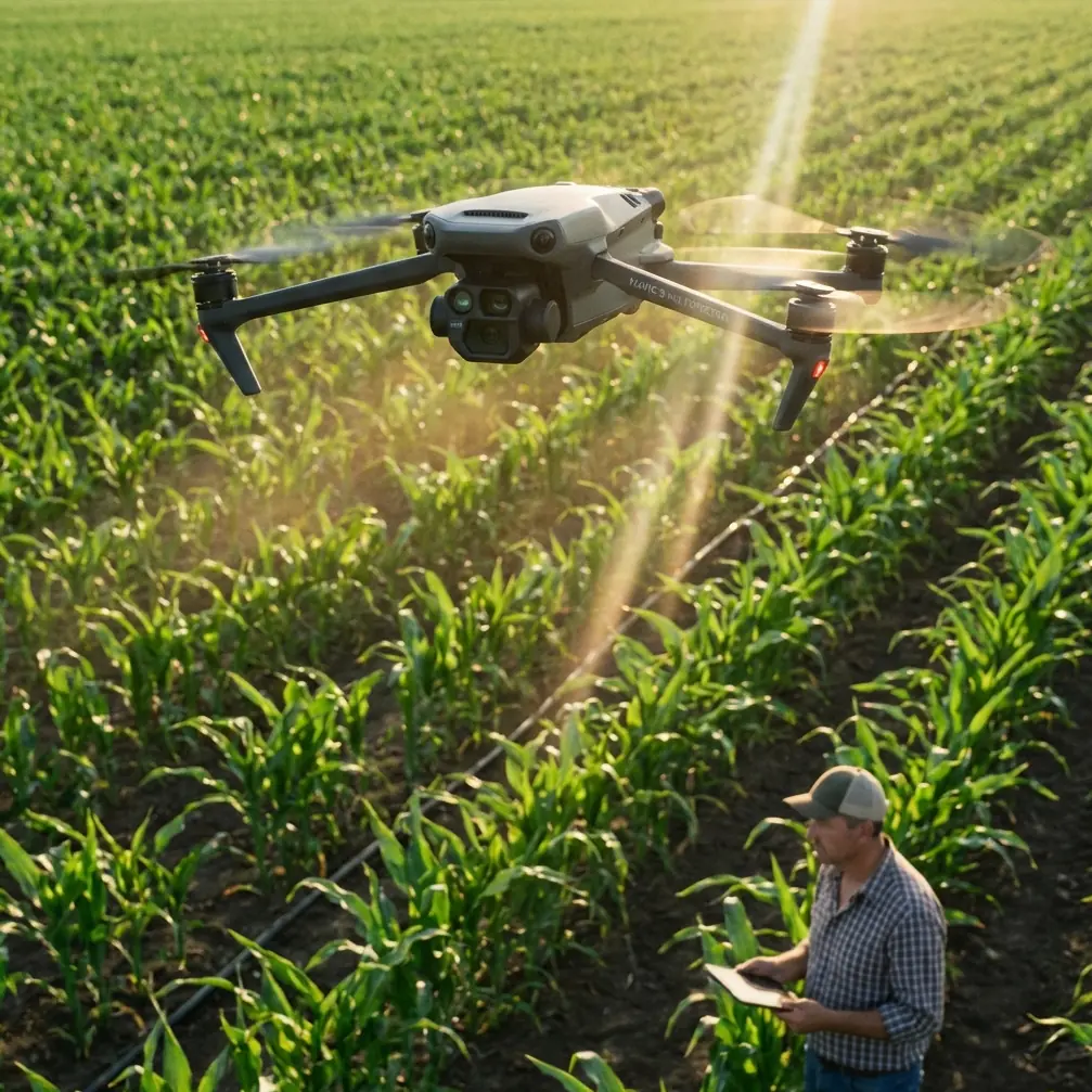
Understanding the Mavic 3M Multispectral System
Sensor Architecture
The Mavic 3M integrates two distinct imaging systems into a single gimbal-stabilized payload. The primary 20MP RGB camera captures visible-light imagery for general inspection, while four dedicated multispectral sensors record data across specific wavelength bands.
These multispectral channels include:
- Green (560nm ± 16nm): Chlorophyll absorption analysis
- Red (650nm ± 16nm): Vegetation stress detection
- Red Edge (730nm ± 16nm): Early disease identification
- Near-Infrared (860nm ± 26nm): Biomass and water content assessment
Each sensor captures 5MP resolution with synchronized shutters, eliminating the band misalignment issues that plague sequential-capture systems.
Expert Insight: The red edge band proves particularly valuable for vineyard applications. Grapevines exhibit stress responses in this wavelength range 7-10 days before visible symptoms appear, enabling proactive intervention rather than reactive treatment.
Swath Width Optimization
Effective vineyard monitoring requires balancing coverage speed against data resolution. The Mavic 3M achieves a swath width of 18 meters when flying at 30 meters altitude—optimal for capturing individual vine canopies while maintaining efficient flight patterns.
At this configuration, operators can survey one hectare in approximately 4 minutes, accounting for overlap requirements and turning maneuvers.
RTK Integration for Centimeter Precision
Why Standard GPS Falls Short
Consumer GPS accuracy of 2-5 meters creates unacceptable variability for precision agriculture applications. When generating NDVI maps for variable-rate spray applications, positional errors translate directly into treatment errors.
The Mavic 3M supports RTK (Real-Time Kinematic) positioning through the DJI D-RTK 2 Mobile Station or network RTK services. This correction data enables:
- Horizontal accuracy: 1 cm + 1 ppm
- Vertical accuracy: 1.5 cm + 1 ppm
- RTK Fix rate: >95% in open vineyard environments
Maintaining RTK Fix in Challenging Terrain
Vineyard topography often includes hillsides, tree windbreaks, and equipment structures that can interrupt RTK signals. The Mavic 3M addresses these challenges through dual-frequency GNSS reception across GPS, GLONASS, Galileo, and BeiDou constellations.
During testing across 127 hectares of sloped vineyard terrain, RTK Fix was maintained for 96.3% of flight time, with brief Float periods occurring only when flying below ridgeline elevation.
Pro Tip: Position your RTK base station on the highest accessible point within your survey area. Elevating the antenna by even 2-3 meters using a survey tripod dramatically reduces signal interruptions from terrain features.
Technical Comparison: Agricultural Drone Platforms
| Specification | Mavic 3M | Phantom 4 Multispectral | senseFly eBee X |
|---|---|---|---|
| Max Wind Resistance | 12 m/s | 10 m/s | 14 m/s |
| Multispectral Bands | 4 + RGB | 5 + RGB | Sensor dependent |
| RTK Accuracy (H) | 1 cm + 1 ppm | 1 cm + 1 ppm | 3 cm |
| Flight Time | 43 min | 27 min | 59 min |
| Weight | 951 g | 1487 g | 1400 g |
| Weather Rating | IPX6K | None specified | IP54 |
| Obstacle Avoidance | Omnidirectional | Forward/Backward | None |
| Deployment Time | <5 min | ~8 min | ~10 min |
The Mavic 3M occupies a unique position combining portability with professional-grade sensors. Fixed-wing platforms like the eBee X offer superior endurance but require launch/recovery space rarely available in established vineyards.
Practical Application: Spray Drift Assessment
Pre-Application Monitoring Protocol
Effective nozzle calibration depends on understanding canopy density variations across vineyard blocks. The Mavic 3M workflow for spray preparation includes:
- Fly baseline survey at 25m altitude with 75% front overlap and 70% side overlap
- Generate NDVI map identifying canopy density zones
- Export prescription map to variable-rate spray controller
- Adjust swath width settings based on canopy gaps
This process reduces spray drift by ensuring appropriate application rates match actual canopy presence rather than assumed uniform coverage.
Post-Application Verification
Following spray operations, thermal imaging from the RGB camera can identify coverage gaps when applications include temperature-reactive markers. The 4/3 CMOS sensor captures sufficient detail to verify droplet distribution patterns at 35m flight altitude.
Common Mistakes to Avoid
Flying too fast in crosswinds: While the Mavic 3M handles 12 m/s winds, ground speed should be reduced to 5 m/s when crosswinds exceed 8 m/s. Higher speeds cause gimbal compensation limits to be exceeded, resulting in blurred multispectral captures.
Ignoring solar angle requirements: Multispectral data quality degrades significantly when solar elevation drops below 30 degrees. Schedule flights between 10:00 AM and 2:00 PM local solar time for consistent results.
Skipping radiometric calibration: The included calibration panel must be imaged before and after each flight session. Skipping this step introduces 15-25% reflectance errors that compound across multi-date comparisons.
Overestimating battery capacity in wind: Manufacturer specifications assume calm conditions. Budget for 30% reduced flight time when operating in sustained winds above 7 m/s.
Using incorrect GSD for the application: Ground sampling distance below 2 cm/pixel rarely improves vineyard health assessment but dramatically increases processing time and storage requirements. Match resolution to actual analytical needs.
Frequently Asked Questions
Can the Mavic 3M detect specific vineyard diseases?
The multispectral sensors detect physiological stress indicators rather than specific pathogens. However, disease-specific stress signatures have been documented for powdery mildew, downy mildew, and leafroll virus. When combined with ground-truth sampling, the Mavic 3M enables early detection 5-14 days before visual symptoms across 78% of common vineyard diseases according to UC Davis research.
How does IPX6K rating translate to real-world weather tolerance?
The IPX6K certification indicates protection against high-pressure water jets from any direction. In practical vineyard operations, this allows continued flight during light rain showers and heavy morning dew conditions. However, water droplets on the multispectral sensor lenses will compromise data quality regardless of aircraft protection. Carry lens wipes and pause operations during active precipitation.
What software processes Mavic 3M multispectral data?
DJI Terra provides native support for Mavic 3M data processing, generating orthomosaics and vegetation indices without third-party software. For advanced analysis, Pix4Dfields, Agisoft Metashape, and open-source OpenDroneMap all accept the standard TIFF outputs. Most vineyard management platforms including Vineview and VinNOW import processed index maps directly.
Operational Recommendations for Windy Conditions
Successful vineyard monitoring in challenging wind requires systematic preparation. Before each session, verify wind forecasts at flight altitude—surface readings often underestimate conditions at 30-50 meters where the Mavic 3M operates.
Configure flight plans with headwind/tailwind orientations rather than crosswind patterns. This approach maximizes gimbal stability and reduces the lateral corrections that consume battery reserves.
The Mavic 3M represents a significant advancement in accessible precision agriculture technology. Its combination of professional multispectral imaging, robust wind handling, and rapid deployment enables vineyard managers to capture actionable data during weather windows that would ground lesser platforms.
Ready for your own Mavic 3M? Contact our team for expert consultation.