Mavic 3M in Complex Terrain: A Field Case Study on Route
Mavic 3M in Complex Terrain: A Field Case Study on Route Design, Endurance Pressure, and Reliable Data Capture
META: Practical Mavic 3M best practices for monitoring venues in complex terrain, with route planning, antenna positioning, landing workflow, and endurance insights tied to real UAV reference data.
When people discuss the Mavic 3M, they usually start with the sensor stack. That makes sense. Multispectral payloads, centimeter-level workflows, and RTK-driven mapping accuracy are what put the aircraft into serious agricultural and land-monitoring conversations.
But in difficult terrain, the sensor is rarely the first thing that limits mission quality.
What usually breaks the workflow is something more basic: the route was wrong for the site, the aircraft spent too much battery on inefficient transitions, signal quality degraded because of poor antenna orientation, or landing became unnecessarily tense because the operator waited too long to come home. Complex venues expose every weak link. Hills, tree lines, narrow access roads, fragmented plots, uneven elevation, and reflective surfaces all punish sloppy planning.
That is where the Mavic 3M becomes interesting. Not because it can simply collect multispectral data, but because it sits at the intersection of route discipline, positioning reliability, and practical field efficiency.
This case study looks at how I would structure a Mavic 3M monitoring workflow for a venue in complex terrain, drawing on two reference ideas that matter more than they first appear: route planning logic from DJI educational material, and an emerging battery-density breakthrough from Tsinghua University’s Shenzhen International Graduate School. The first affects what you can do today. The second hints at what may soon change in daily UAV operations.
The site: a fragmented venue, not a clean survey block
Imagine a monitoring venue spread across mixed ground conditions: terraces on one side, irregular open areas in the middle, a road corridor along the edge, and patches of vegetation that need repeated health assessment. This is not a neat rectangle where one quick grid solves everything.
For the Mavic 3M, that distinction matters.
A lot of operators still approach every site as if it were a flat, uniform block. They draw one mission, watch the aircraft fly, and hope the output can be stitched into something useful later. That works until terrain complexity starts imposing real penalties: inconsistent swath coverage, unnecessary overlap in one section, gaps in another, poor image geometry for elevation-sensitive areas, and avoidable battery consumption.
The educational UAV document in the reference material makes a deceptively simple point: flight routes should be selected based on the task and the scene, not treated as a one-size-fits-all pattern. It specifically distinguishes between three route types—“弓字形” flight paths, “井字形” flight paths, and custom routes—and ties them to different operational needs. That principle transfers directly to Mavic 3M work.
The operational significance is straightforward:
- A lawnmower-style pattern is efficient for broad area coverage.
- A crosshatch or orthogonal pattern is better when 3D fidelity matters.
- A custom route is often the right answer for linear or irregular targets.
For a complex monitoring venue, using just one of those modes is usually a compromise. Using all three, selectively, is often the smarter move.
How I would break the mission down
For the broader vegetation blocks, I would start with a standard area-coverage route to gather consistent multispectral imagery. That gives the best balance between coverage speed and predictable overlap. In practical terms, this is where swath width, overlap settings, and terrain-following decisions shape the dataset long before any analysis begins.
For sections that need more structural understanding—erosion-prone slopes, embankments, drainage transitions, or stepped terrain where perspective affects interpretation—I would add a second pass from an intersecting direction. The reference document notes that a “井字形” route is commonly used for high-precision 3D modeling. That matters operationally because oblique relationships and cross-direction imagery reduce blind spots and improve reconstruction confidence in uneven terrain.
Then there are the venue edges: roads, fence lines, water channels, utility margins. These are where custom route design earns its keep. The same source explicitly links custom routes to inspections along roads, rivers, railways, transmission corridors, and coastlines. A complex venue often contains smaller versions of those linear assets. Flying a generic area grid across them is wasteful. A custom corridor route is cleaner, faster, and easier on the battery.
That mix—broad coverage, targeted crosshatch, and custom linear runs—is often the difference between a dataset that is merely complete and one that is operationally useful.
Why endurance still shapes Mavic 3M mission quality
Now to the less glamorous issue: endurance pressure.
The reference news item from Tsinghua is not about the Mavic 3M specifically, but it points to a development that every serious drone operator should pay attention to. Associate Professor Zhou Guangmin’s team at Tsinghua Shenzhen International Graduate School proposed a functional molecular design method for lithium-sulfur batteries, described as building molecules like modular blocks. The reported result is a major increase in energy density, with the headline framing it as a doubling effect.
That is not just a battery-lab headline. It speaks directly to field operations.
In complex terrain, aircraft do not spend energy only on the productive part of the mission. They spend it on climbing, repositioning, route corrections, conservative returns, and fighting inefficient geometry caused by poor planning. Higher energy density could eventually reduce the constant tradeoff between mission completeness and battery reserve. For platforms like the Mavic 3M, that would mean fewer forced breaks in coverage, larger workable sectors per sortie, and less temptation for operators to push batteries to uncomfortable margins.
Until that future arrives, the discipline has to come from planning.
If battery technology doubles energy density one day, route planning still matters. It just matters differently. You gain margin. You do not gain the right to be sloppy.
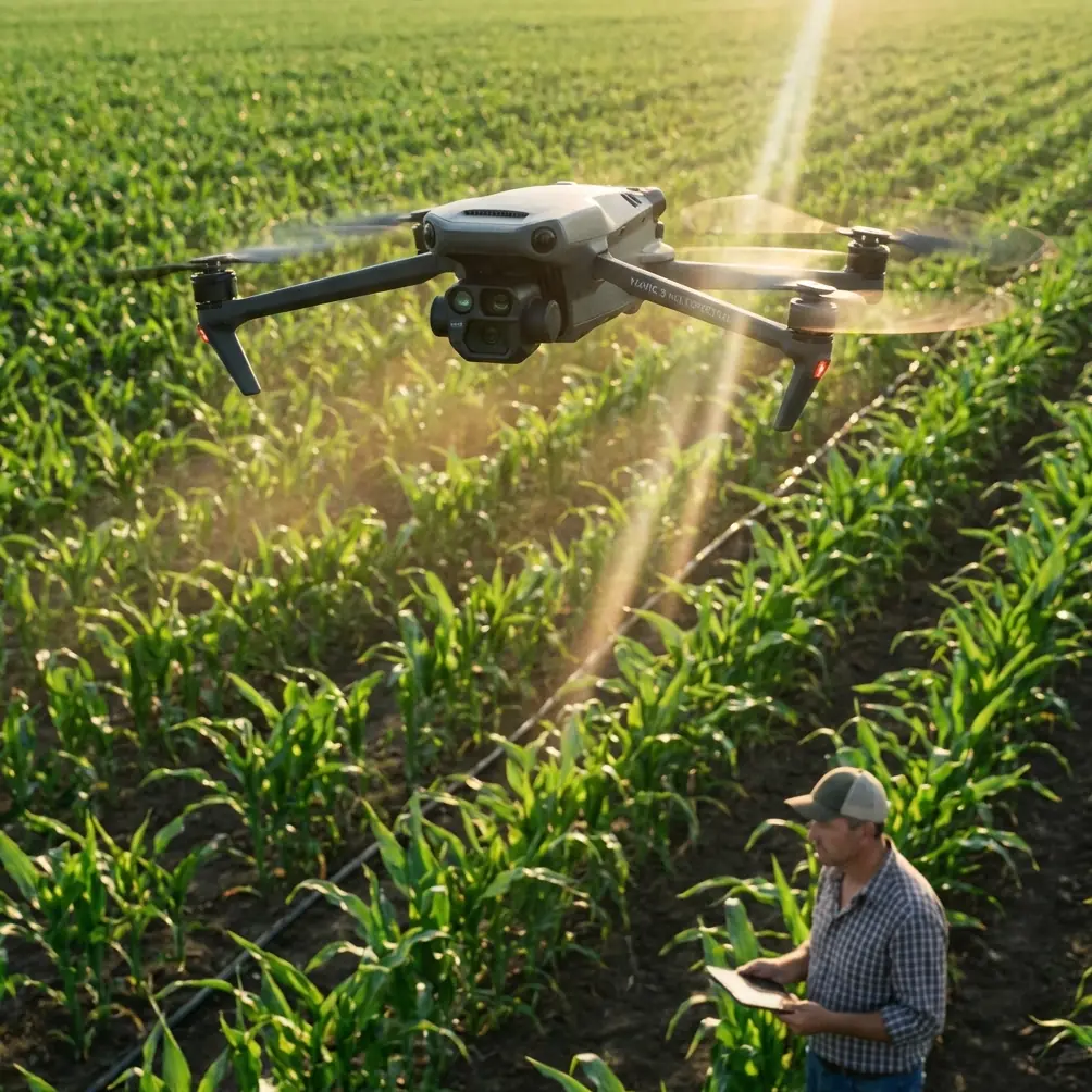
The hidden productivity factor: RTK discipline and antenna positioning
Many operators chasing centimeter precision focus only on whether RTK is enabled. That is too superficial. In complex terrain, what matters is whether the aircraft maintains a stable RTK fix rate throughout the mission, not just whether the menu says the feature is active.
Tree lines, rock faces, built structures, and terrain shadow can all degrade positional consistency. That can show up later as uneven alignment, extra cleanup work, or confidence issues in repeat surveys. For Mavic 3M missions intended to compare vegetation conditions over time, repeatability is not optional. If one dataset is weakly anchored, the whole trend analysis becomes harder to trust.
This is where the user scenario’s prompt about antenna positioning deserves practical attention.
My field advice is simple:
- Place the remote controller where it has the cleanest possible line of sight to the aircraft’s working area, not where it is most comfortable for you to stand.
- Keep your body from blocking the path between controller and aircraft during long lateral passes.
- In hilly venues, move upslope if needed rather than trying to fly the entire mission from a signal shadow.
- Before starting the main mission, do a short range-and-altitude check to verify control and video stability in the real geometry of the site.
- If using an RTK service or correction workflow, confirm a healthy fix before entering the most terrain-obstructed segment.
This sounds elementary, but it is one of the easiest ways to improve maximum practical range and mission stability without changing the aircraft at all. The best antenna setup is often just better operator positioning.
If you want a second opinion on field layout and controller placement before a difficult survey, I sometimes suggest teams share a site sketch and mission draft through this planning chat channel so route geometry and signal exposure can be reviewed before deployment.
Auto landing is not a convenience feature in rough venues
Another detail from the educational source deserves more respect than it usually gets: the automatic landing system is described as a safe and feasible assisted landing method that can align the aircraft with the runway and reduce pilot workload during landing.
On the surface, that sounds like a training note from a different class of aircraft. In practice, the underlying lesson applies directly to Mavic 3M operations in uneven venues. Landing is part of mission quality. If your takeoff and recovery area is narrow, dusty, sloped, or bordered by obstacles, fatigue and time pressure show up most clearly at the end of the flight.
The operational significance here is not about pretending every drone mission has a runway. It is about treating recovery as a planned phase rather than an afterthought.
For Mavic 3M work, that means:
- selecting a recovery zone before takeoff, not at low battery;
- preserving enough reserve to execute a calm return;
- avoiding last-minute manual improvisation near trees, poles, vehicles, or spectators;
- using assisted landing logic where appropriate to reduce operator load.
This is especially relevant when the mission includes repeated sorties over a large venue. The first landing may be smooth. The fourth one, after heat, glare, and cumulative workload, is where discipline really counts.
What complex terrain does to multispectral interpretation
Multispectral data in difficult landscapes can look deceptively clean while still hiding operational flaws. Uneven terrain changes the angle of view. Fragmented vegetation introduces mixed pixels along edges. Repeated climbs and turns can alter pacing and continuity across the route. If the aircraft spent too much time repositioning because the route shape did not fit the venue, the data may still process, but the mission was less efficient than it should have been.
That matters for recurring monitoring.
If the same venue is flown monthly, route consistency becomes just as valuable as sensor capability. A route that mirrors the site geometry reduces noise in repeat comparisons. It also improves confidence when evaluating irrigation patterns, stress zones, access impact, or drainage behavior. Even when the end use touches themes like spray drift assessment or treatment planning support, the quality of the route often determines whether the map is decision-grade.
Nozzle calibration and application planning belong to a different operational layer than Mavic 3M imaging, but there is a practical bridge between them: accurate multispectral monitoring helps define where intervention is necessary and where it is not. That only works if the map is spatially reliable and repeatable.
Training matters more than aircraft prestige
The older aerobatic training reference may seem unrelated at first glance, but one line is timeless: once a maneuver becomes standardized, the mental effort required to perform it drops sharply, freeing the pilot to refine the result. It also stresses that a straight horizontal line parallel to the runway is the basis for more advanced work.
That idea belongs in commercial drone operations too.
Standardized preflight, standardized route logic, standardized controller handling, standardized recovery. These habits are what let an operator focus on data quality instead of basic aircraft management. With the Mavic 3M, the goal is not flashy flying. It is repeatable execution.
In a complex venue, I want the pilot thinking about:
- whether terrain sections should be split into separate missions,
- whether overlap remains sufficient on the slope face,
- whether the RTK fix rate is staying healthy,
- whether the return path is still clean.
I do not want that pilot burning attention on improvised basics.
A practical Mavic 3M workflow for complex monitoring venues
If I were writing a field SOP from this case, it would look like this:
First, classify the site into area blocks, structure-sensitive blocks, and linear assets.
Second, assign the right route form to each: standard grid, crosshatch where needed, and custom path for corridors.
Third, choose the controller position based on line-of-sight and antenna effectiveness, not shade or convenience.
Fourth, confirm RTK stability before committing the aircraft to the most obstructed segment.
Fifth, preserve landing margin and treat recovery as part of mission design.
Sixth, keep route logic consistent across repeat surveys so multispectral comparisons stay trustworthy.
That is not glamorous, but it is what produces usable outputs.
The Mavic 3M is at its best when the mission architecture respects the venue. Complex terrain does not require more guesswork. It requires more structure.
And that is why the two reference threads here fit together so well. One shows that route selection must follow scene requirements, whether the mission is area mapping, 3D modeling, or corridor inspection. The other points toward a future where battery energy density may increase dramatically, potentially easing one of the biggest practical limits in drone work. Put those together and the lesson is clear: smarter aircraft will help, but smarter planning is still the first multiplier.
Ready for your own Mavic 3M? Contact our team for expert consultation.