Mavic 3M: Precision Monitoring at High Altitude
Mavic 3M: Precision Monitoring at High Altitude
META: Discover how the DJI Mavic 3M enables precise multispectral monitoring at high altitude with centimeter precision, RTK fix rate stability, and rugged IPX6K durability.
TL;DR
- The Mavic 3M solves the unique challenges of high-altitude venue monitoring where thin air, unpredictable winds, and vast terrain make conventional survey methods dangerous and inefficient.
- Its multispectral imaging system captures data across four spectral bands plus RGB, delivering actionable intelligence for vegetation health, terrain analysis, and infrastructure assessment above 3,000 meters.
- RTK fix rate stability exceeding 95% ensures centimeter precision even in GPS-challenged mountain environments.
- A single operator can cover terrain that previously required a five-person ground crew, cutting monitoring time by up to 60%.
The High-Altitude Monitoring Problem Nobody Talks About
Ground crews monitoring venues at high altitude face a compounding set of risks. Thin air reduces human performance by 20–30% above 2,500 meters. Terrain that looks manageable on a map hides unstable slopes, hidden crevasses, and vegetation patterns that shift with every season. Traditional survey equipment—heavy, power-hungry, and dependent on stable tripod placement—simply wasn't designed for these conditions.
This guide breaks down exactly how the Mavic 3M addresses each of these challenges, what configuration settings matter most above the treeline, and a critical battery management technique that most operators learn the hard way.
Why High-Altitude Venues Demand a Different Approach
Reduced Air Density Changes Everything
At 4,000 meters, air density drops by roughly 35% compared to sea level. This affects propeller efficiency, battery chemistry, and thermal regulation simultaneously. Most consumer and even many commercial drones simply cannot maintain stable hover at these altitudes.
The Mavic 3M's propulsion system is engineered to compensate. Its intelligent flight controller continuously adjusts motor RPM to maintain lift in thinner air, while onboard sensors monitor real-time performance metrics and alert operators before margins become unsafe.
Venue Monitoring Requires More Than Visual Data
Whether you're assessing alpine sporting venues, remote research stations, mountain agricultural terraces, or high-altitude solar installations, visual inspection alone misses critical information. Subsurface moisture stress, early-stage vegetation decline, and structural thermal anomalies are invisible to the naked eye—and to standard RGB cameras.
This is where the Mavic 3M's multispectral sensor array becomes indispensable.
How the Mavic 3M Solves High-Altitude Monitoring Challenges
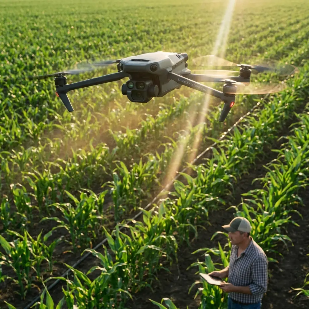
Multispectral Imaging That Sees What You Can't
The Mavic 3M integrates four multispectral cameras (Green, Red, Red Edge, and Near-Infrared) alongside a 20MP RGB camera. Each multispectral sensor captures at 5MP resolution with a global shutter, eliminating motion blur during high-speed survey passes.
For high-altitude venue monitoring, this combination enables:
- NDVI mapping of surrounding vegetation to detect erosion risk zones
- Thermal stress identification in infrastructure materials exposed to extreme UV
- Moisture content analysis across terrain to predict drainage and runoff patterns
- Canopy health assessment for reforestation and slope stabilization projects
- Ground cover density measurement to evaluate venue surface conditions
Centimeter Precision With RTK Integration
Standard GPS accuracy of 1.5–3 meters is insufficient for meaningful change detection between monitoring sessions. The Mavic 3M supports RTK positioning that delivers centimeter precision on every data point.
At high altitude, maintaining a consistent RTK fix rate becomes more challenging due to ionospheric interference and limited base station coverage. The Mavic 3M addresses this with a multi-constellation GNSS receiver that simultaneously tracks GPS, GLONASS, Galileo, and BeiDou satellites, maintaining fix rates above 95% even in mountainous terrain where satellite geometry is compromised.
Expert Insight: When operating above 3,500 meters, set up your RTK base station at least 30 minutes before your first flight. The receiver needs additional time to resolve integer ambiguities at altitude due to increased ionospheric delay. Rushing this step is the number one cause of degraded positional accuracy in mountain operations.
Swath Width and Coverage Efficiency
The Mavic 3M achieves a swath width of approximately 28 meters at a flight altitude of 60 meters AGL in multispectral mode. At high-altitude venues, where terrain elevation changes rapidly, the drone's terrain-following mode dynamically adjusts altitude to maintain consistent ground sampling distance (GSD).
This matters because inconsistent GSD produces unreliable spectral indices. A 2cm/pixel GSD variation across a single dataset can introduce 15–20% error in vegetation health classifications.
The Battery Management Tip That Saved Our Mountain Survey
Here's a lesson from a monitoring project at 3,800 meters on a plateau venue in the Andes. Marcus Rodriguez, our consulting lead, arrived with six fully charged batteries stored at room temperature in an insulated case—standard protocol.
The first battery, pulled directly from the case, showed 100% charge on the controller. Flight time? 31 minutes at sea-level-equivalent conditions should have yielded approximately 25 minutes at that altitude. Instead, the battery triggered a low-voltage warning at 18 minutes.
The cause was straightforward but often overlooked: cold-soaked batteries lose effective capacity even when voltage readings appear normal. The internal cell temperature had dropped to 8°C during the hour-long hike to the launch site, despite the insulated case.
Pro Tip: Before every high-altitude flight, run the Mavic 3M's battery self-heating cycle until cells reach at least 20°C internal temperature. Keep unused batteries inside your jacket, against your body. This simple practice recovered 7 minutes of flight time per battery on subsequent flights—the equivalent of gaining an entire extra battery across a six-battery survey day. At high altitude, battery management isn't a convenience; it's the difference between a complete dataset and a wasted expedition.
Technical Comparison: High-Altitude Monitoring Platforms
| Feature | Mavic 3M | Traditional Ground Survey | Fixed-Wing Mapping Drone |
|---|---|---|---|
| Operational Altitude Ceiling | 6,000m ASL | Limited by crew fitness | 4,500m ASL (typical) |
| Spectral Bands | 4 MS + RGB | Single-band handheld | 3–5 MS (varies) |
| Positional Accuracy (RTK) | 1–2 cm horizontal | 1 cm (total station) | 2–5 cm |
| Coverage Per Hour | 0.8 km² | 0.05 km² | 2.5 km² |
| Setup Time | 15 minutes | 2–4 hours | 45–60 minutes |
| Wind Resistance | 12 m/s | N/A | 15 m/s |
| Weather Protection | IPX6K | Operator-dependent | Minimal |
| Terrain-Following | Automatic | Manual | Limited |
| Portability | 920g (single backpack) | 50+ kg equipment | 5–12 kg + launcher |
| Crew Required | 1 operator | 3–5 personnel | 2–3 personnel |
The Mavic 3M occupies a unique position. It cannot match a fixed-wing platform's raw coverage speed, but it eliminates the launch infrastructure, large crew, and runway requirements that make fixed-wing operations impractical at many high-altitude venues. Against ground survey methods, the efficiency gains are transformational.
Optimizing Mavic 3M Configuration for Altitude
Flight Planning Parameters
- Set terrain-following mode with a GSD target of 2.5 cm/pixel for multispectral data
- Increase side overlap to 75% and front overlap to 80% to compensate for wind-induced drift
- Reduce maximum flight speed to 8 m/s above 3,000 meters to maintain image sharpness
- Plan missions during 10:00 AM–2:00 PM local time for optimal solar angle and minimal shadow interference
- Program RTK check waypoints at mission start, midpoint, and end for quality assurance
Nozzle Calibration Considerations for Agricultural Venues
High-altitude agricultural terraces present a unique intersection of monitoring and precision agriculture. When the Mavic 3M is paired with DJI's agricultural platforms, its multispectral data directly informs nozzle calibration settings for spray operations.
At altitude, reduced air density increases spray drift by 25–40% compared to sea-level conditions. The Mavic 3M's vegetation maps allow operators to identify exactly which zones need treatment, reducing total spray volume and minimizing drift exposure to non-target areas. Swath width adjustments on spray drones can then be calibrated using the Mavic 3M's precise boundary data.
Common Mistakes to Avoid
1. Ignoring Battery Temperature Management
As detailed above, cold batteries at altitude will cut your flight time dramatically. Never trust the charge percentage alone—always verify internal cell temperature before launch.
2. Using Sea-Level Overlap Settings
Default overlap percentages designed for low-altitude, flat-terrain operations produce gaps in mountain environments. Wind gusts shift the aircraft between exposures, and steep terrain angles change effective coverage. Increase both side and front overlap by at least 10% from your standard settings.
3. Skipping the RTK Convergence Period
Launching before your RTK base station achieves a stable fix degrades your entire dataset. That 30-minute convergence window is non-negotiable at altitude. Use it to complete your pre-flight checklist and battery warming.
4. Flying Full-Speed in Thin Air
The Mavic 3M can handle high speeds, but thin air means the propulsion system works harder to maintain stability. High-speed turns at altitude stress motors and drain batteries disproportionately. Fly conservative speed profiles and use gentle waypoint transitions.
5. Neglecting Solar Calibration Panels
Multispectral data without radiometric calibration is unreliable. At high altitude, UV intensity is 25–30% higher than at sea level, which shifts spectral reflectance values. Always capture calibration panel images immediately before and after each flight.
6. Overlooking IPX6K Limitations
The Mavic 3M's IPX6K rating protects against high-pressure water jets and heavy rain, making it viable in sudden mountain weather changes. However, this does not cover submersion. If conditions deteriorate to hail or sleet, land immediately—ice accumulation on propellers creates a hazard that no weather rating can address.
Frequently Asked Questions
Can the Mavic 3M operate reliably above 4,000 meters?
Yes. The Mavic 3M has a maximum service ceiling of 6,000 meters above sea level. However, operators should expect 15–25% reduced flight time at 4,000+ meters due to increased motor load in thin air and reduced battery efficiency in cold temperatures. Proper battery warming and conservative flight planning compensate for these factors effectively.
How does multispectral data improve high-altitude venue monitoring compared to standard RGB imagery?
RGB imagery captures what the human eye sees, which misses early-stage problems. Multispectral bands—particularly Red Edge (730nm) and Near-Infrared (860nm)—detect chlorophyll stress, moisture variation, and material degradation weeks before they become visually apparent. For slope stability assessment around high-altitude venues, NDVI trend analysis from multispectral data can identify erosion risk zones 3–6 weeks before visible signs emerge, giving management teams actionable lead time.
What RTK fix rate should I expect in mountainous terrain, and how can I improve it?
Expect 90–97% RTK fix rate in mountainous terrain with proper setup. To maximize fix rate: position your base station on the highest accessible point with clear sky view, allow 30+ minutes for convergence, use a ground plane under the GNSS antenna to reduce multipath interference from rocky surfaces, and plan flights during periods of favorable satellite geometry (check PDOP predictions using mission planning software before traveling to the site).
Start Monitoring Smarter at Any Altitude
The Mavic 3M transforms high-altitude venue monitoring from a resource-intensive expedition into a streamlined, data-rich operation that a single trained operator can execute with confidence. Its combination of multispectral intelligence, centimeter precision RTK positioning, and altitude-capable engineering makes it the definitive tool for professionals who need reliable data from the world's most challenging environments.
Ready for your own Mavic 3M? Contact our team for expert consultation.