Monitoring Solar Farms with the Mavic 3M in Low Light
Monitoring Solar Farms with the Mavic 3M in Low Light: A Technical Review from the Field
META: A field-based technical review of using the DJI Mavic 3M for low-light solar farm monitoring, with practical insight on multispectral data, RTK accuracy, weather shifts, and agricultural workflow lessons that improve mission reliability.
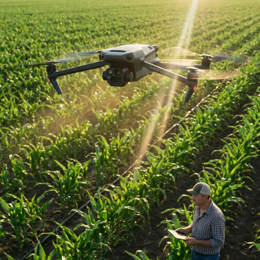
The Mavic 3M is usually discussed in an agricultural context, and for good reason. Its multispectral workflow was built around crop intelligence, plant vigor mapping, and repeatable low-altitude data capture. But that same architecture becomes surprisingly useful on solar sites, especially when inspections need to happen in marginal light and operators still need consistent, georeferenced results.
That is where the aircraft becomes more interesting than its label.
I have spent enough time around utility operators and drone teams to know that low-light solar farm work is rarely about making pretty maps. It is about finding operational change early, documenting conditions with enough positional confidence to act, and doing it without turning a short weather window into a messy field exercise. The Mavic 3M sits in an unusual position here: it is not a thermal-first platform, yet it brings a sensing stack and mission discipline that can make solar monitoring much more structured than many teams expect.
Why a farm drone makes sense on a solar farm
A national low-altitude economy push in China recently highlighted four use environments for unmanned systems: precision agricultural spraying, intelligent inspection, low-altitude logistics, and passenger-oriented convenience aviation. That framing matters because it reflects where drone value is actually being proven at scale. Inspection is no longer a niche add-on. It is one of the core categories shaping how low-altitude systems are being adopted in real operations.
Solar monitoring fits squarely inside that inspection category.
The Mavic 3M’s real advantage is not that it was marketed for agriculture. It is that agriculture forced the platform to solve two difficult problems that inspection teams also face: extracting subtle surface-level variation from reflected light, and doing it repeatably across large areas. In crop work, that means identifying stress tied to biomass, nitrogen deficiency, canopy density, and leaf-area changes. On a solar farm, the target is different, but the operational discipline carries over. You still need clean flight lines, reliable overlap, stable georeferencing, and data that remains comparable from one mission to the next.
That is a stronger foundation than many ad hoc visual inspection routines.
Low-light conditions expose weak workflows fast
Solar farm monitoring in low light sounds straightforward until you actually fly it. Dawn, late dusk, overcast winter afternoons, and dust-heavy atmospheric conditions all compress your margin. The aircraft has less visual contrast to work with. Human observers are more likely to miss subtle anomalies. Shadows lengthen and change shape across rows. Wind can rise while illumination drops. If your workflow depends on loose piloting and vague notes, the data set becomes hard to trust.
This is where the Mavic 3M’s mission-oriented design starts to matter more than the headline specs.
The strongest lesson comes from hyperspectral and multispectral remote sensing research rather than from generic drone marketing. Studies referenced in the source material show that crop biomass has a strong relationship with reflectance in two spectral regions: a positive correlation in the near-infrared band from 740 to 1100 nm, and a negative correlation in the red band from 620 to 700 nm. In crop science, those relationships help estimate growth and vigor. Operationally, what matters for solar teams is the broader principle: small reflectance shifts can be meaningful, and the useful signal often lives beyond what the eye sees comfortably in weak light.
That is why multispectral tools can still contribute when visible-light interpretation gets less certain.
I am not suggesting that a solar technician should treat a panel array like a corn canopy. The point is more practical than that. The same remote sensing logic that makes non-destructive nitrogen and biomass assessment possible also explains why structured multispectral capture can reveal pattern changes that a visual-only sortie may under-document. When light gets flat and the site is large, disciplined spectral collection becomes less of a luxury and more of a method.
The significance of multispectral on a solar site
One underappreciated benefit of the Mavic 3M is that it encourages operators to think in layers rather than snapshots. Agricultural users do this naturally because they monitor trends: biomass, chlorophyll-related shifts, nutrient stress, and treatment impact. The source research even notes that nitrogen stress alters leaf area index, biomass, coverage, chlorophyll content, and protein content, all of which then change the crop canopy’s reflected spectrum. That chain of cause and effect is useful as a mental model for solar work too.
On a solar farm, you are also trying to connect surface-level signals to underlying operational conditions.
Maybe a row section is showing a repeatable reflectance difference after soiling. Maybe one area has standing moisture nearby affecting ground conditions and panel surroundings. Maybe vegetation encroachment is beginning to change the maintenance profile around strings and access lanes. Maybe the issue is not electrical at all, but environmental, and the first clue appears as a subtle pattern variation when the site is flown consistently over time.
The Mavic 3M is good at building that consistency.
Its value is not just “multispectral.” It is that a multispectral workflow makes the operator less casual. You plan the mission. You care about overlap. You care about swath width and repeatability. You verify whether the aircraft has a stable RTK fix rate before trusting positional outputs. You become much less likely to return from the field with a folder full of images that look fine but cannot be aligned into a dependable time-series record.
That is where centimeter precision changes the conversation. On large solar assets, a few meters of uncertainty is often enough to waste maintenance time. Teams do not just need “an issue somewhere in block C.” They need location confidence that stands up when a technician walks out with a task list.
What happened when weather changed mid-flight
One of the better demonstrations of the Mavic 3M’s practicality came during a low-light inspection window that started calm and ended awkwardly.
We launched under a muted sky just after first light. Illumination was low but workable. The goal was to capture consistent coverage across several array rows and compare them against earlier mapped baselines. About a third of the way through the mission, the weather shifted. Wind picked up unevenly across the site as cooler air moved through, and the soft light that had been stable at launch turned patchy. Not dramatic. Just enough to make a careless data set unreliable.
This is exactly the kind of moment where field discipline matters more than aircraft hype.
Agricultural flight operations offer a useful benchmark here. According to the operational reference material, spray teams treat wind above level 3 as a serious drift risk and generally stop chemical application when temperatures exceed 35 degrees C because performance and treatment quality can degrade. A solar inspection mission is obviously not spraying, but those thresholds are still instructive because they reflect a mature habit: environmental limits should drive the mission, not pilot optimism.
So we did what good ag teams do. We reassessed rather than forcing completion.
The Mavic 3M handled the flight segment well, but “handled it” does not mean “ignore changing conditions.” The aircraft maintained mission stability, and the positional consistency remained usable. What changed was our confidence in uniform illumination across the next passes. Instead of pretending all data is equal, we split the mission record and flagged the weather transition point. That preserved the utility of the earlier capture and kept the later segment from contaminating the comparison set.
This is one reason I trust operators with agricultural discipline on industrial sites. They are used to respecting the environment because the environment directly affects data quality and operational outcome.
Lessons solar operators can borrow from spray teams
The source material on plant-protection drone service teams may seem far removed from solar monitoring at first glance. It is not. In fact, some of the best habits for industrial drone work come from agricultural crews that have to produce repeatable field results day after day.
Take logistics. The reference notes that electric multirotors commonly require 5 to 10 battery sets, plus chargers, and in areas without convenient charging, teams may carry onboard generation equipment. That is not a glamorous detail, but it is one of the clearest signs of professional readiness. Solar farms are often in remote or semi-remote areas where travel time is longer than expected and weather windows are shorter than planned. If your low-light mission depends on “we should have enough power,” you are already operating below standard.
Then there is the after-action process. Good spray teams log daily acreage, flight counts, chemical usage, and whether application totals match the actual treated area. Translate that mindset to solar work and the value is obvious. Log covered sections, battery cycles, completed corridors, anomalies flagged, reflight zones, and any changes in light or wind during the sortie. Inspection quality improves when the team can reconstruct exactly what happened, not when they rely on memory at the truck.
Even safety culture transfers well. Spray teams check route obstacles, establish takeoff and landing points, verify radio coordination, and maintain separation between aircraft operations and bystanders. On a solar site, that same discipline reduces rushed launches between rows, poor staging near maintenance traffic, and avoidable mission interruptions.
The keywords change. The principle does not.
Calibration, drift, and the details that separate useful data from noise
Readers searching for Mavic 3M advice often arrive with agriculture terms in mind: spray drift, nozzle calibration, swath width. Those are not solar metrics, but they still point toward the right operating philosophy.
Spray drift is really about environmental sensitivity. On a solar farm, the equivalent concern is not droplets drifting off target; it is data validity drifting out of tolerance because wind, changing light, or inconsistent altitude alters capture conditions.
Nozzle calibration is about system verification before work begins. In a monitoring mission, that translates into preflight sensor checks, mission parameter confirmation, and making sure RTK is behaving the way you think it is. If the RTK fix rate is unstable, you should know before the third flight line, not after processing.
Swath width matters because it controls coverage efficiency and overlap logic. On solar assets with repeating geometry, a poorly chosen swath can create avoidable shadow complexity, incomplete row representation, or excessive processing burden. A tighter, more deliberate plan often beats trying to grab everything in one broad pass.
And then there is weather resistance. Operators often focus on outright rain when they should be thinking more broadly about site toughness. Dust, damp mornings, residue on landing zones, and uneven field conditions all punish sloppy gear handling. That is why ruggedization matters. If your workflow assumes clean pavement and controlled launch conditions, it does not reflect how many utility-scale sites actually behave. Practical resilience matters every bit as much as sensor sophistication.
Where the Mavic 3M fits best
The Mavic 3M is not the answer to every solar inspection requirement. If your entire operation revolves around thermal fault detection, there are other platforms better aligned with that mission set. But if your need is repeatable geospatial monitoring, multispectral pattern tracking, vegetation-related assessment around assets, low-light documentation with stronger consistency, and clean integration into site-level comparison workflows, the Mavic 3M earns serious attention.
Its strongest use case is not flashy one-off discovery. It is disciplined repeatability.
That is why I would place it with teams that already value procedure: preflight checks, environmental go/no-go thresholds, repeatable mission planning, and accurate logging. The drone benefits from operators who understand that data collection is not just flying. It is systems work.
If you are building a low-light solar monitoring program around the Mavic 3M and want a second set of eyes on workflow design, battery planning, or mission repeatability, you can message Marcus directly here.
Final assessment
The most useful way to judge the Mavic 3M on solar farms is not by asking whether it was originally intended for that market. The better question is whether its sensing logic and operating model solve real inspection problems under real site conditions.
Based on the reference material, the answer is yes—especially when you understand why.
The national low-altitude economy framing shows inspection is one of the central civilian use cases driving drone adoption. The hyperspectral research shows that meaningful operational insight often comes from reflectance behavior that is structured, measurable, and not always obvious to the eye, especially when light is weak. The agricultural operations guidance shows that mission success depends just as much on batteries, environmental thresholds, logging, and field discipline as it does on the aircraft itself.
Put those together and the Mavic 3M stops looking like “a farm drone used for something else.” It starts looking like a well-disciplined remote sensing platform that happens to transfer extremely well into low-light solar monitoring when the operator knows how to use it.
Ready for your own Mavic 3M? Contact our team for expert consultation.