Mavic 3M for Mountain Power Line Monitoring: A Safer
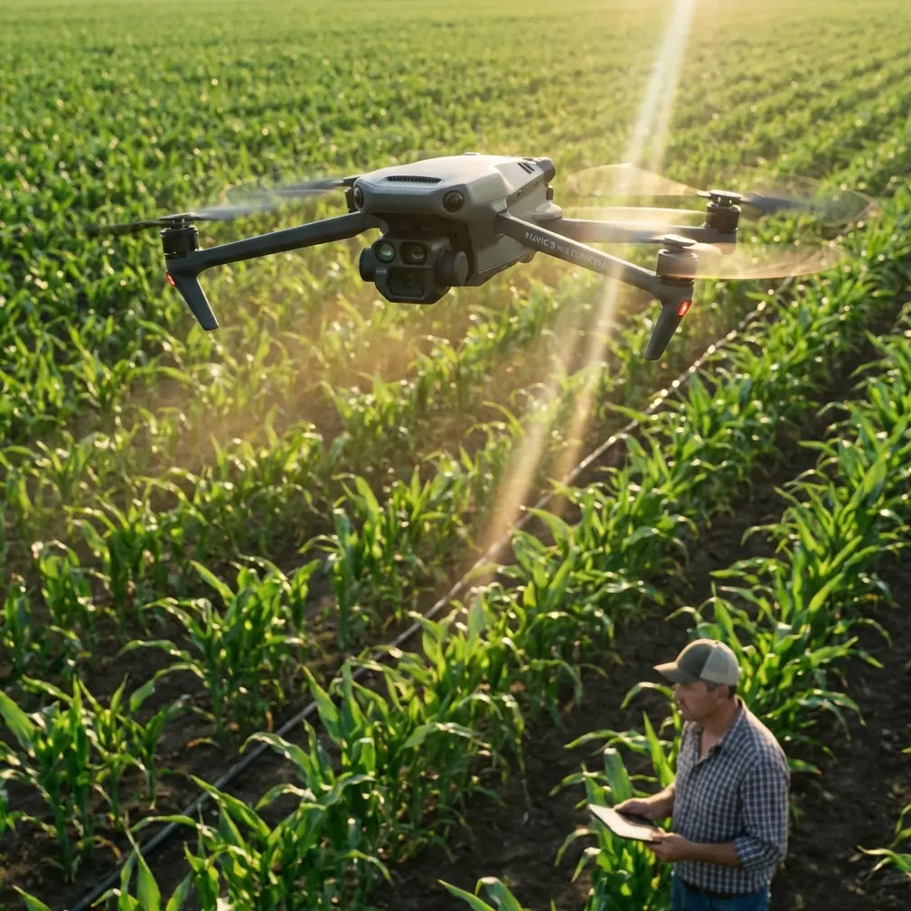
Mavic 3M for Mountain Power Line Monitoring: A Safer, Smarter Workflow That Starts Before Takeoff
META: Learn how the Mavic 3M fits mountain power line monitoring, from pre-flight cleaning and sensor readiness to multispectral workflows, RTK accuracy, and safer utility inspections.
Mountain power line inspection is rarely limited by flight time alone. The real constraint is trust in the data when terrain is steep, access is poor, and each sortie has to count.
That is where the Mavic 3M becomes interesting.
Not because it is simply another compact drone with mapping credentials, but because it sits at an unusual intersection: portable enough for crews hiking into remote corridors, precise enough for repeatable geospatial work, and flexible enough to support vegetation and right-of-way monitoring around critical utility infrastructure. In mountain environments, those three things matter more than spec-sheet bragging rights. A drone that is easy to carry but weak on positioning creates uncertainty. A drone with excellent sensors but cumbersome field handling slows down teams who are already dealing with altitude, wind, and narrow launch zones. The Mavic 3M is valuable when it closes that gap.
For utilities monitoring power lines in mountainous regions, the challenge is not just “see the line.” It is understanding the condition of the corridor around it, documenting encroaching vegetation, spotting changes in slope stability, and generating maps that can be compared over time with confidence. The aircraft has to support those goals without adding friction to the crew’s day.
The real problem in mountain inspections
Power line routes in mountain terrain create a difficult mix of operational risks. Slopes distort visual perspective. Dense vegetation can hide access roads and tower bases. Wind conditions shift quickly along ridgelines. GNSS quality can vary as crews move between open valleys and more obstructed sections. Even when a pilot can safely fly the route, the next question is harder: can the resulting data support decisions about maintenance, trimming, or follow-up ground work?
That is why utility teams increasingly look beyond standard RGB imagery. A visual image may show obvious issues, but it does not always reveal subtle vegetation stress, moisture variation, or early signs that a corridor is becoming harder to manage. This is where the Mavic 3M’s multispectral capability starts to matter in practical terms, not as a buzzword.
Multispectral data gives crews another layer of evidence. Around mountain power lines, that can help distinguish healthy vegetation from stressed growth patterns and support corridor management planning before the issue becomes a clearance problem. If a section of vegetation shows unusual changes over repeat flights, the operator can prioritize a closer review rather than relying on broad assumptions from a single visual pass.
Why multispectral matters more in the mountains
In flatter environments, utility teams can often compensate with easier access, vehicle-based surveys, or repeated field visits. Mountain corridors are less forgiving. Every climb, every repositioning, and every extra hour in the field adds exposure and cost.
The Mavic 3M changes the inspection conversation because multispectral collection can turn one flight into a richer dataset. That helps crews make better use of small weather windows and short daylight periods common in mountain work. When teams can pair visual context with multispectral insight, they are less likely to miss gradual environmental shifts along the route.
This is especially useful for vegetation management near transmission and distribution assets. A line corridor is not static. Growth patterns vary by slope aspect, drainage, seasonal stress, and recent weather. Multispectral imagery helps highlight those differences with more consistency than visual interpretation alone. For utilities trying to monitor changes over time, that consistency is operationally significant.
It also supports better communication between field teams and planners. A pilot may suspect a section needs attention, but mapped multispectral outputs make that concern easier to share with engineers, vegetation managers, and contractors who were not on the mountain that day.
Accuracy is not a luxury here
Mountain monitoring demands repeatability. If the same corridor is flown month after month, the value is not just in each map as a standalone product. The value is in comparing one dataset against another and spotting meaningful change.
That is where centimeter precision and RTK performance come into play.
If your RTK fix rate is inconsistent, your confidence in repeat mapping drops. Small position errors can make a vegetation change look larger or smaller than it really is, especially when teams are trying to evaluate narrow clearances near conductors or compare slope-edge movement around tower sites. In mountain environments, where the geometry of the terrain already complicates interpretation, reliable positioning is not a nice extra. It is the backbone of decision-grade mapping.
The Mavic 3M’s appeal for this kind of work is not just that it can collect multispectral imagery, but that it can do so in a workflow built around precise geospatial output. Centimeter-level positioning supports corridor maps that are easier to align across inspections. That means less time arguing about whether a change is real and more time acting on verified findings.
Start with the part crews often rush: pre-flight cleaning
The safest inspection workflow begins before the aircraft arms.
A practical mountain routine should include a quick but deliberate pre-flight cleaning step, especially around obstacle sensing surfaces, cameras, and landing gear contact points. Dust, pollen, fine grit, and moisture residue accumulate faster than many teams expect when launching from gravel pullouts, alpine tracks, or damp grass clearings. If a sensor window is smeared or a lens has residue, the aircraft may still fly, but the reliability of safety and imaging functions can be compromised.
This is not cosmetic maintenance. It is operational risk control.
On power line jobs, obstacle awareness matters because crews may launch in constrained areas with brush, rocks, utility structures, and uneven terrain nearby. Clean sensing surfaces help the aircraft interpret its surroundings more reliably during takeoff and landing, the moments when mountain flights often feel the least forgiving. Clean optics also protect the quality of multispectral and RGB capture, which is the whole reason the sortie is happening in the first place.
A sensible field habit is simple:
- Wipe sensor and camera surfaces with a clean microfiber cloth before battery one.
- Check for moisture spots after moving from a cold vehicle to warmer field air.
- Inspect the underside and landing area for grit that could affect a stable takeoff.
- Confirm propellers are free of debris after walking through brush or tall grass.
That two-minute ritual can prevent data quality problems and reduce avoidable flight anomalies.
A compact aircraft makes a difference when access is ugly
Mountain utility inspections are full of logistics that never appear in product brochures. Maybe the crew parks far below the target span. Maybe they need to cross uneven ground with batteries, landing pad, radios, and PPE. Maybe the launch site has just enough room for a careful hand-carry setup and nothing more.
This is where the Mavic 3M’s form factor earns its keep.
A more portable platform reduces fatigue before the mission even starts. That matters because tired crews make slower decisions and are more likely to skip procedural discipline. In remote power line monitoring, a compact aircraft can be the difference between reaching the correct observation point and settling for a less useful angle because the team is already overloaded.
Portability also supports rapid redeployment. If wind shifts along a ridge or a line segment needs to be observed from a safer location, crews can reposition quickly without dismantling a larger system. That flexibility is underrated in mountain operations, where the best launch point on paper is not always the best launch point in real conditions.
Building a practical corridor workflow
For mountain power line monitoring, the strongest Mavic 3M workflows are usually not built around one heroic flight. They are built around repeatable passes and clean handoffs.
A solid process often looks like this:
First, fly a broad corridor mapping mission to establish the environmental picture. Use multispectral outputs to identify vegetation zones that deserve more attention. Then review areas where growth patterns, stress signatures, or terrain changes suggest higher future risk. After that, schedule targeted follow-up flights for those sections under comparable lighting and positioning conditions. Over time, this creates a far more useful maintenance record than ad hoc visual checks alone.
That approach becomes even stronger when teams standardize their launch and data capture habits. Consistent altitude, overlap, and route structure help preserve comparability between datasets. Swath width planning also matters. Too wide, and the mission may trade detail for speed in places where narrow clearances need closer interpretation. Too narrow, and teams may spend excessive time in the air over terrain that only needs routine monitoring. The right balance depends on corridor width, terrain complexity, and the level of detail the utility actually needs for action.
The same logic applies to RTK setup. If crews are serious about change detection, they should treat RTK readiness as mission-critical. A strong fix rate is part of the inspection standard, not an optional enhancement. That is how a utility turns drone data from “interesting imagery” into a dependable operational layer.
What not to borrow from unrelated drone narratives
There is a temptation in UAV content to drag in adjacent industry talking points just because they are popular. That can create confusion.
For example, terms like spray drift, nozzle calibration, and IPX6K belong to other drone discussions, especially agricultural spraying platforms. They matter in their own category, but they are not what defines the Mavic 3M’s value on a mountain power line job. Here, the core story is different: multispectral awareness, repeatable mapping, field portability, and disciplined pre-flight readiness.
That distinction matters because utility buyers and operators do not need recycled drone language. They need clarity about whether an aircraft fits their terrain, their inspection cadence, and their data expectations.
Why this platform fits a consultant’s recommendation
If I were advising a utility team or contractor on a mountain corridor program, I would not frame the Mavic 3M as a replacement for every inspection method. That would be sloppy. There are still situations where ground patrols, manned observation, or other specialized tools play a role.
I would frame it as a strong first-response mapping and vegetation intelligence platform for difficult terrain.
It helps teams get into the field without dragging a heavy system uphill. It supports data capture that goes beyond ordinary visual imagery. And when paired with a disciplined RTK workflow, it creates repeatable outputs that make trend analysis more credible. Those are concrete advantages, not abstract promises.
If a crew wants to compare corridor conditions before and after a storm season, monitor vegetation pressure near remote spans, or document changes in tower access zones over time, the Mavic 3M is well positioned for that work. Its value is highest when the operator treats it as part of a method, not just a flying camera.
A note on airspace awareness around critical infrastructure
Utilities working near critical infrastructure also need discipline around who is in the air and why. Broader drone industry news has shown increasing attention on systems designed to detect, track, and classify small unmanned aircraft, including solutions aimed at Group 1–3 drones and functions spanning detection, tracking, and decision support. For civilian utility operators, the takeaway is straightforward: responsible, well-documented flight operations are becoming more important around sensitive assets.
That does not change the Mavic 3M’s role in inspection. It reinforces the need for clear authorization, transparent operating procedures, and professional field behavior. In mountain power line monitoring, the technical mission and the compliance mission now travel together.
The bottom line
The Mavic 3M makes the most sense in mountain power line monitoring when the objective is not merely to fly, but to return with evidence that supports action.
Its multispectral capability matters because mountain vegetation does not fail on a convenient schedule. Its precision matters because repeatability is the difference between seeing change and guessing at it. Its portability matters because access is often the hidden cost of utility inspection. And the humble pre-flight cleaning step matters because safety systems and imaging quality only work as well as the surfaces crews keep clear.
If your team is planning a corridor workflow and wants to talk through mission design, data capture standards, or field setup habits, you can message a consultant here and discuss the operational side before the next deployment.
Ready for your own Mavic 3M? Contact our team for expert consultation.