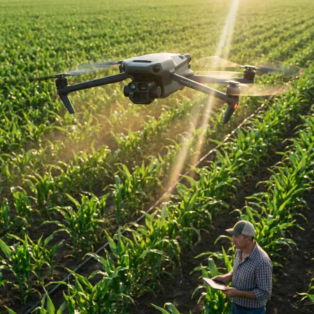
Mavic 3M for Windy Highway Monitoring: A Field Tutorial
Mavic 3M for Windy Highway Monitoring: A Field Tutorial Shaped by the New Drone Security Reality
META: Expert tutorial on using the Mavic 3M for windy highway monitoring, with practical flight strategy, multispectral workflow, and lessons from new drone misuse and counter-drone developments.
Highway monitoring with a Mavic 3M is no longer just a question of flight technique. The bigger issue now is trust: who is flying, why they are flying, and how quickly legitimate operators can prove they belong in the air.
That matters because two recent developments point in the same direction. In China, prosecutors have publicly raised concern over drones being modified into illegal “aerial hunters,” arguing that the answer is not only tighter law but coordinated oversight and stronger social boundaries around how technology is used. In the US, Warren County Community College in New Jersey has launched a counter-drone security curriculum designed to train students and working professionals to identify, assess, and respond to drone threats.
If you operate a Mavic 3M along highways, especially in windy corridors, those stories are not background noise. They directly affect mission planning, site communication, and how your data operation will be perceived by road authorities, contractors, and the public.
I’ll walk through this as I would in the field: not as theory, but as a practical tutorial for using the Mavic 3M on a highway monitoring mission when the wind shifts mid-flight and scrutiny around drones is rising.
Why these two news items matter to Mavic 3M operators
The first story is blunt. A prosecutor in Chun’an County, Li Hanying, argued that solving drone modification and misuse requires legal updates, coordinated regulation, and a broader public understanding that technology has limits. That is a precise warning for professional operators. A highway shoulder survey may be lawful, documented, and safety-driven, but from the ground, an observer often sees only one thing: a drone near critical infrastructure.
The second story adds the operational consequence. Warren County Community College is not simply expanding general drone education; it is building a counter-drone security program so students and professionals can identify and respond to drone threats. Read that carefully. The people around your worksite are increasingly likely to be trained to challenge unknown aircraft activity.
For a Mavic 3M user, this shifts the standard from “fly safely” to “fly safely and transparently.” Your aircraft may have advanced multispectral capability, centimeter precision workflows, and a strong navigation stack, but none of that helps if a highway patrol unit, infrastructure manager, or private security team assumes your drone is part of the problem.
So the tutorial starts before takeoff.
Step 1: Frame the mission as infrastructure monitoring, not just data capture
The Mavic 3M is often discussed through agriculture because of its Multispectral payload. That is too narrow for highway work. On a windy corridor, the aircraft becomes a compact remote sensing platform for vegetation encroachment checks, drainage pattern observation, slope stress indicators, shoulder condition review, and corridor change detection.
The operational significance of multispectral data here is simple: highways are living edges. Vegetation growth, water pooling, and embankment stress can change gradually, then all at once after weather. RGB imagery shows what is visible. Multispectral data helps flag what is changing before it becomes obvious from a windshield or a standard inspection pass.
When I brief a client, I make the use case concrete:
- Identify vegetation stress near guardrails and medians
- Track drainage anomalies after shifting weather
- Document corridor conditions consistently across repeated flights
- Reduce unnecessary roadside exposure for inspection crews
That framing matters because it distinguishes a legitimate Mavic 3M mission from the kind of improvised or suspicious operation that current enforcement and counter-drone programs are built to stop.
Step 2: Build a flight profile for wind, not for perfect conditions
Highways create awkward wind behavior. Open lanes accelerate gusts. Overpasses shear airflow. Sloped shoulders produce uneven turbulence. Sound barriers and tree lines can create short pockets of relative calm followed by unstable crosswinds.
On paper, your route may look simple: long linear passes, consistent altitude, tidy overlap. In practice, highway flying in wind is about preserving data quality while keeping the aircraft out of energy-wasting corrections.
Here is the field method I use with a Mavic 3M:
- Fly the first leg into the prevailing wind when possible
- Keep lateral offsets predictable rather than hugging traffic edges
- Shorten leg lengths when gusts are building
- Treat overlaps as a wind-management tool, not just a mapping setting
- Watch heading stability more closely than groundspeed alone
This is where RTK Fix rate becomes more than a technical checkbox. In highway monitoring, positional consistency is what allows repeated flights to be compared over time. If the mission is built around Centimeter precision, but wind forces constant attitude corrections and your fix quality degrades, your data may still look good at first glance while becoming less reliable for change analysis.
That distinction becomes critical when the same corridor is flown after a storm, after resurfacing activity, or during vegetation management cycles.
Step 3: Plan for the weather to change mid-flight
This is not hypothetical. It happened on one of my recent highway-style corridor jobs.
We launched under manageable morning conditions. Wind was steady enough to support clean linear passes. About halfway through the second segment, the sky flattened into that dull gray look that often arrives before the air starts behaving differently. Then it did. Gusts became less consistent, with short crosswind hits near an elevated section of roadway. A few minutes later, the pattern shifted again, and what had been a headwind on the outbound pass turned into a diagonal push across the corridor.
This is where the Mavic 3M earns its place. It did not “ignore” the wind. No serious pilot expects that. What it did was stay predictable. The aircraft held the route tightly enough to preserve useful overlap, and the positioning workflow remained stable enough to continue collecting data without turning the mission into a battery-draining fight.
The practical lesson is not that the drone is invincible. It is that a well-planned Mavic 3M mission can absorb a mid-flight weather change if the operator has already built margin into the route.
My adaptation sequence looked like this:
- Reduced the active segment length
- Rechecked wind direction against the road alignment
- Increased attention to image consistency rather than trying to preserve the original timeline
- Chose a safer return point with clearer air on the leeward side of the corridor
- Logged the weather break so downstream analysis would account for the change
That last point gets skipped too often. If weather changes mid-flight, annotate it. Highway asset teams and engineering reviewers need context. A clean data set is valuable. A clean data set with flight-condition notes is far more defensible.
Step 4: Use multispectral intentionally in a highway environment
The temptation with a Mavic 3M is to collect multispectral layers because they are available. That is backwards. Start with the operational question.
On highways, the strongest use cases usually involve:
- Vegetation stress near pavement margins
- Moisture-related anomalies around culverts and ditches
- Early signs of slope or embankment instability
- Repeated corridor comparisons after weather swings
This is where the broader drone misuse story becomes relevant in a subtle way. As authorities worry more about modified drones and as institutions begin training people to identify drone threats, professional crews need to demonstrate disciplined sensor use. If you are collecting multispectral data, you should be able to explain why that sensor matters for the corridor and what decision it supports.
That answer should sound like engineering, not gadget enthusiasm.
If a client asks why you are not using an ag platform instead, I explain that the Mavic 3M fits constrained roadside work well because it is efficient to deploy, precise enough for repeatable monitoring, and flexible in mixed environments where access points are limited. In a windy corridor, that agility matters.
Step 5: Borrow the right lessons from ag workflows, ignore the wrong ones
The context hints around Spray drift, Nozzle calibration, and Swath width come from agricultural operations, and they are still useful here if you interpret them correctly.
You are not spraying a highway corridor with a Mavic 3M, but the logic behind those concepts translates well:
Spray driftteaches respect for lateral movement in unstable airNozzle calibrationreminds operators that precision work depends on repeatable setup, not assumptionsSwath widthbecomes a mental model for corridor coverage discipline
In other words, the habits that make aerial application safer and more accurate can improve highway monitoring even when no liquid is involved. Wind changes coverage quality. Setup consistency affects comparability. Corridor width assumptions can quietly ruin your mapping if they are not checked against real conditions.
This matters even more when your deliverable is intended to support maintenance planning or post-weather assessment. A Mavic 3M flight that looks complete but has inconsistent corridor coverage is worse than a shorter mission with documented, reliable segments.
Step 6: Treat security awareness as part of the checklist
Because of the recent news, I would now place site transparency much higher on the preflight list.
The prosecutor’s warning in China was not just about misuse in the abstract. It specifically addressed drone modification abuse and the need for legal and social boundaries around technology. The WCCC program is equally specific: it trains people to identify and respond to drone threats.
For highway operators, the operational significance is immediate:
- Expect more questions from site personnel
- Expect less tolerance for unclear flight activity
- Expect drone presence near infrastructure to be judged through a security lens
That means your checklist should include:
- Written mission purpose
- Site contacts informed in advance
- Visible operator identification where appropriate
- Clear geospatial limits for the flight area
- A response plan if challenged during operations
I also recommend having a concise explanation ready in plain language. Not a paragraph. Two sentences. Something like: we are conducting authorized corridor monitoring with a Mavic 3M to document vegetation, drainage, and surface-adjacent conditions for infrastructure review. We are operating within a defined area and can confirm mission details with the site contact.
That kind of clarity can prevent confusion before it becomes escalation.
If you need a fast way to coordinate field access and mission timing with stakeholders, I often suggest using a direct message channel like send the flight window here so everyone sees the same launch and recovery plan.
Step 7: Protect the legitimacy of your data operation
This is the deeper takeaway from both news items. Drone professionalism is no longer judged only by stick skill, image quality, or report polish. It is judged by whether your operation visibly respects boundaries.
A Mavic 3M mission over or beside a highway can produce excellent corridor intelligence. But if operators fail to account for security perception, they create friction that eventually harms everyone doing legitimate infrastructure work.
That is why I advise three things on every windy highway monitoring job:
First, preserve Centimeter precision only when the field conditions support it. Do not promise survey-grade consistency if wind and signal conditions are undermining repeatability.
Second, document environmental shifts. Mid-flight weather changes affect interpretation, and the record matters.
Third, operate as if trained observers may be watching. Because increasingly, they are.
A practical Mavic 3M workflow for windy highways
If I were handing this to a field team tomorrow, the condensed workflow would look like this:
- Define the corridor objective before selecting the flight pattern.
- Confirm that multispectral capture supports a real maintenance or inspection decision.
- Plan shorter, wind-aware segments rather than one long perfect-route fantasy.
- Watch
RTK Fix rateand route stability together, not separately. - If weather shifts mid-flight, preserve data integrity before schedule.
- Log the change in conditions for downstream analysis.
- Brief site contacts so the mission is immediately recognizable as legitimate infrastructure work.
That is how a Mavic 3M stays useful in the current environment: not by pretending the airspace conversation has not changed, but by meeting it head-on with discipline.
The aircraft remains a strong tool for highway monitoring in wind. Its Multispectral capability gives teams a way to see corridor conditions that ordinary imagery can miss. Its precision workflow supports repeat monitoring when the mission is well structured. And in real field conditions, including flights where the weather turns during the job, it can remain steady enough to deliver meaningful results.
But that technical capability now sits inside a new reality. One recent news item warns that drones can be turned into illegal “aerial hunters,” prompting calls for tighter legal frameworks and better coordinated oversight. Another shows formal counter-drone training expanding in New Jersey, with a curriculum specifically designed to teach people how to identify and respond to drone threats.
For Mavic 3M operators on highway jobs, the lesson is clear: fly well, document well, and make the legitimacy of the mission obvious. In 2026 and beyond, those are no longer separate skills.
Ready for your own Mavic 3M? Contact our team for expert consultation.