Mavic 3M in Mountain Forest Monitoring: Why Landing Logic
Mavic 3M in Mountain Forest Monitoring: Why Landing Logic and Visual Discipline Matter More Than Spec Sheets
META: A field-based expert look at using the DJI Mavic 3M for mountain forest monitoring, with practical insight on composition, precision landing logic, RTK reliability, and electromagnetic interference handling.
Mountain forest monitoring has a way of exposing weak assumptions.
On paper, the Mavic 3M looks perfectly suited to the job: multispectral capture, compact airframe, efficient coverage, and the kind of positioning workflow that promises centimeter-class results when RTK conditions cooperate. In the field, though, the real test is not whether the aircraft has advanced sensors. It is whether the operator can consistently collect usable data on steep terrain, under unstable wind, near ridge-induced interference, and then bring the aircraft back onto a safe landing point without turning the final meters into the riskiest part of the mission.
That is the frame I want to use for the Mavic 3M here. Not as a brochure object, but as a working tool for mountain forestry teams who need repeatable outcomes.
A mountain forest case that changed the workflow
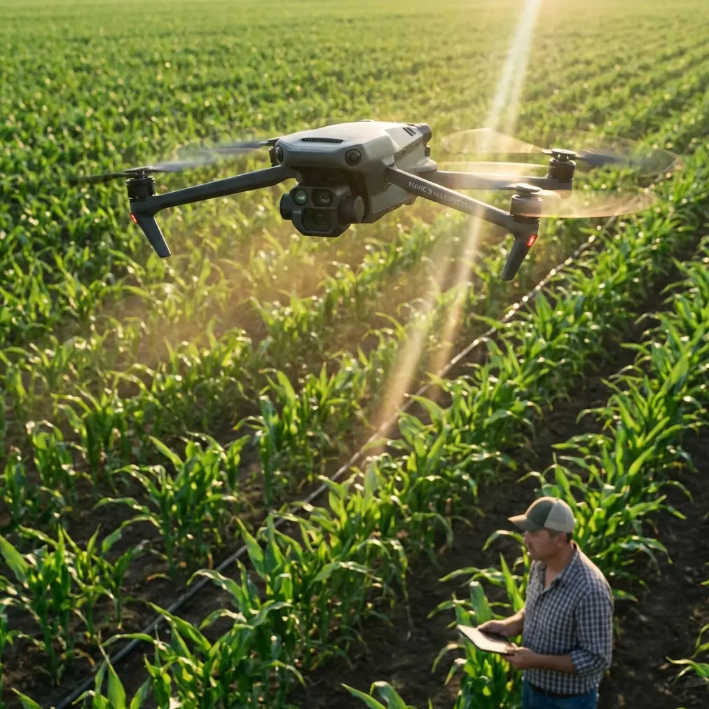
On a recent forest health monitoring project in upland terrain, the assignment seemed straightforward: map canopy variability across a fragmented mountain slope, detect stress patterns with multispectral imagery, and repeat the mission later for comparison. The aircraft of choice was the Mavic 3M because portability mattered. The team had to hike to launch points, often carrying batteries, markers, handheld receivers, and field notebooks over uneven ground. A larger platform would have increased payload flexibility, but that advantage would have been offset by access friction.
The surprises began before takeoff.
The launch zone sat near a service ridge with metal fencing, power hardware, and a communications relay farther upslope. None of that prevented flight, but it did create intermittent electromagnetic noise that influenced heading confidence and made preflight checks less clean than expected. In flat farmland, this kind of issue is often solved by simply moving a few meters. In mountain forestry, you may have only one safe patch of open ground.
That is where procedure matters more than enthusiasm.
We adjusted the ground station layout, increased spacing between control devices and metallic gear, and altered antenna orientation to maintain the strongest possible link through the slope geometry. That sounds small. It is not. In ridged terrain, a poor antenna angle can quietly erode signal quality, especially when the aircraft drops below a tree-lined shoulder or slips behind a contour. The Mavic 3M is capable, but no drone can compensate for careless RF posture by the operator.
The mission eventually succeeded, but not because the sensor suite was magical. It succeeded because the team treated image quality, navigation quality, and landing quality as one connected system.
The hidden lesson from a photography article
One of the more useful reference points for Mavic 3M operations did not come from a drone manual at all. It came from a photography composition article published on 2026-05-19 by 御空逐影 in a technology news section. Its core argument was blunt: many failed photos are lost at the moment of capture, not because the camera or lens is lacking, but because the framing decision was wrong from the start. It also pushed back against the habit of assuming post-processing can rescue weak source material.
That principle transfers directly to forest monitoring.
Multispectral work is often described in technical language—reflectance, band alignment, overlap, RTK, processing chains—but the practical foundation is still visual discipline. If the operator launches with a poorly considered flight geometry, inconsistent terrain clearance, or badly chosen takeoff and landing zones, then later processing becomes an attempt to repair structural problems introduced in the field.
In mountain forests, composition is not about making the image pretty. It is about organizing the scene so the data will remain interpretable.
For the Mavic 3M, that means thinking carefully about:
- how the swath width behaves over changing elevation,
- how oblique terrain edges can affect canopy interpretation,
- whether the route orientation will create repeatable passes on future dates,
- and whether the aircraft’s visual perspective near the ground will support reliable landing recognition.
The article’s point about “failure at the shooting stage” is operationally significant because forestry teams often overestimate what software can fix afterward. If ridge shadow, mismatched overlaps, or unstable altitude produce weak source imagery, the map may still render. That does not mean it will support confident biological interpretation.
Why the last meter deserves more respect than the first kilometer
One of the most overlooked technical truths in UAV fieldwork appears in a teaching document about precise landing. It explains that when a drone descends to roughly 100 centimeters above a marked target, airflow and related disturbances can still make a precise touchdown difficult. The solution described is elegant and practical: instead of treating descent as one smooth final drop, divide the landing into stages. At each step down, the drone reassesses relative position, adjusts attitude, and continues refining until it reaches the target.
This is more than a classroom exercise.
In mountain forest monitoring, the return and landing phase is where fatigue, wind channeling, and terrain-induced turbulence converge. Operators tend to focus on mission planning, RTK fix rate, and multispectral data integrity, but a poor touchdown on a sloped or cluttered mountain site can undo an otherwise excellent flight day.
For the Mavic 3M, that landing concept matters in two ways.
First, it reinforces the value of visual recognition around the home point. The educational reference notes that a drone can record approximate GPS information at takeoff and also capture the target pattern of the launch area. Later, after completing the mission, it returns to the landing zone using GPS and then refines the approach with image recognition of the ground target, adjusting its position based on the relative offset between drone and target. In operational terms, that means the aircraft does not rely on one positioning source alone. It layers location logic.
Second, it explains why forest teams should treat landing-pad design as part of the data workflow. A clearly visible landing marker, good contrast, and enough open margin around the pad can improve recovery consistency in mixed light. In a mountain clearing, especially where branches, rocks, and gusts complicate descent, that extra visual certainty is not cosmetic. It is risk control.
I have seen teams obsess over centimeter precision in map outputs while landing onto ambiguous ground cover that confuses the aircraft’s visual reference. That is backwards.
RTK fix rate is only useful if the environment lets you hold it
The Mavic 3M’s value in forestry is closely tied to repeatability. Multispectral comparison across time is strongest when the aircraft follows a stable and well-referenced mission. That is where centimeter precision and RTK workflows become meaningful, not as buzzwords, but as a way to reduce spatial uncertainty between flights.
Still, mountain terrain punishes anyone who treats RTK as automatic.
A strong RTK fix rate can degrade near ridges, under partial sky obstruction, or when operators set up in cramped launch pockets where line-of-sight to satellites is compromised. Add electromagnetic interference from local infrastructure and you have a more complex navigation picture than the spec sheet suggests.
This is where antenna adjustment enters the story in a practical way. On our mountain forest mission, we noticed that link quality changed sharply when the aircraft crossed behind a shoulder lined with dense trees. The immediate instinct for some crews is to blame the drone or the terrain and push through. A better response is to reconsider operator stance, controller direction, and antenna angle relative to the aircraft’s actual path, not its map icon alone. In complex terrain, the best signal posture at takeoff may not remain the best signal posture halfway through the route.
This matters for the Mavic 3M because multispectral data collection depends on consistency. A temporary navigation or link issue does not merely threaten convenience; it can compromise pass continuity, overlap confidence, and the reliability of later analysis. Forest health change detection is unforgiving when acquisition conditions vary too much.
The deeper historical lesson: stability has always been hard-won
A technical history document on multirotor development gives useful perspective. Early designs were often ambitious and underdelivered. One example described a large quadrotor built by De Bothezat in 1921 that was expected to reach 100 meters but managed only 5 meters. Another noted that Oemichen, after redesign, achieved a then-record 14-minute helicopter flight in 1923. These are not just historical curiosities.
They remind us that stable vertical flight, especially controllable and practical flight, is the result of incremental refinement rather than a single leap. Today’s Mavic 3M feels polished because a century of aeronautical trial, failure, redesign, and control-system maturation sits behind every stable hover and autonomous track line.
That historical context is useful for forestry operators because it encourages humility. Even now, with mature autopilot systems, the hardest problems often reappear in familiar forms: maintaining stability in disturbed air, controlling descent close to the ground, and preserving navigation confidence in imperfect environments. The tools are better. The physics did not retire.
Multispectral value depends on mission discipline, not just the sensor block
For mountain forest monitoring, the Mavic 3M’s multispectral capability is the headline feature, and rightly so. It allows teams to move beyond visual impressions and into structured vegetation assessment. But the sensor only produces strong forestry intelligence when field execution is equally strong.
A few operational points stand out:
Terrain-aware route design
Swath width on paper is one thing; swath behavior over mountain relief is another. On steep slopes, effective coverage shifts as terrain rises into the flight envelope. If route planning ignores that, overlap can become uneven, particularly along canopy edges and gullies.
Repeatable launch and recovery setup
If the same forest block will be monitored over time, use a repeatable ground arrangement. The earlier education reference on visual target recognition supports this logic. A consistent landing target helps the aircraft return more precisely, and a consistent takeoff zone improves comparability across missions.
Controlled descent behavior
The staged-descent idea from the landing reference is operationally significant because downwash and crossflow near the ground can displace small aircraft during the final approach. In a mountain clearing, stepping down with repeated positional correction is simply smarter than trusting a single uninterrupted drop.
Better source imagery beats heroic processing
The photography reference was correct. Teams that assume later software will compensate for poor capture discipline usually end up spending more time defending questionable data. Good composition in this context means clean route structure, appropriate altitude, stable coverage, and careful framing of the operational scene from the beginning.
A practical note on field support
For crews preparing similar mountain forest workflows with the Mavic 3M, especially where signal behavior and landing setup are uncertain, it helps to review deployment details before heading uphill. If you need a field-oriented discussion on route planning, RTK behavior, or interference mitigation, this direct Mavic 3M setup line is a sensible starting point.
What separates a successful Mavic 3M forest mission from an average one
The difference is rarely the obvious spec.
It is usually the quality of judgment around three moments: before takeoff, during terrain-driven signal transitions, and in the last meter of descent.
The best Mavic 3M operators in mountain forestry do not think of imaging, positioning, and landing as separate tasks. They build them into one chain. They understand that a mission can fail at the shooting stage, just as the composition article argued. They appreciate that precise landing is not trivial, especially when even a descent from around 100 centimeters can be destabilized by airflow. And they respect the old truth from multirotor history: reliable vertical flight has always been earned through disciplined control, not wishful thinking.
That is why the Mavic 3M works so well in mountain forest monitoring when it is used properly. Not because it removes complexity, but because it gives a well-trained team the tools to manage it.
Ready for your own Mavic 3M? Contact our team for expert consultation.