Mavic 3M for Urban Forest Monitoring: A Practical Field
Mavic 3M for Urban Forest Monitoring: A Practical Field Method for Interference, RTK Stability, and Usable Multispectral Data
META: A field-focused tutorial on using Mavic 3M for urban forest monitoring, with practical guidance on electromagnetic interference, antenna adjustment, RTK fix reliability, and multispectral workflow discipline.
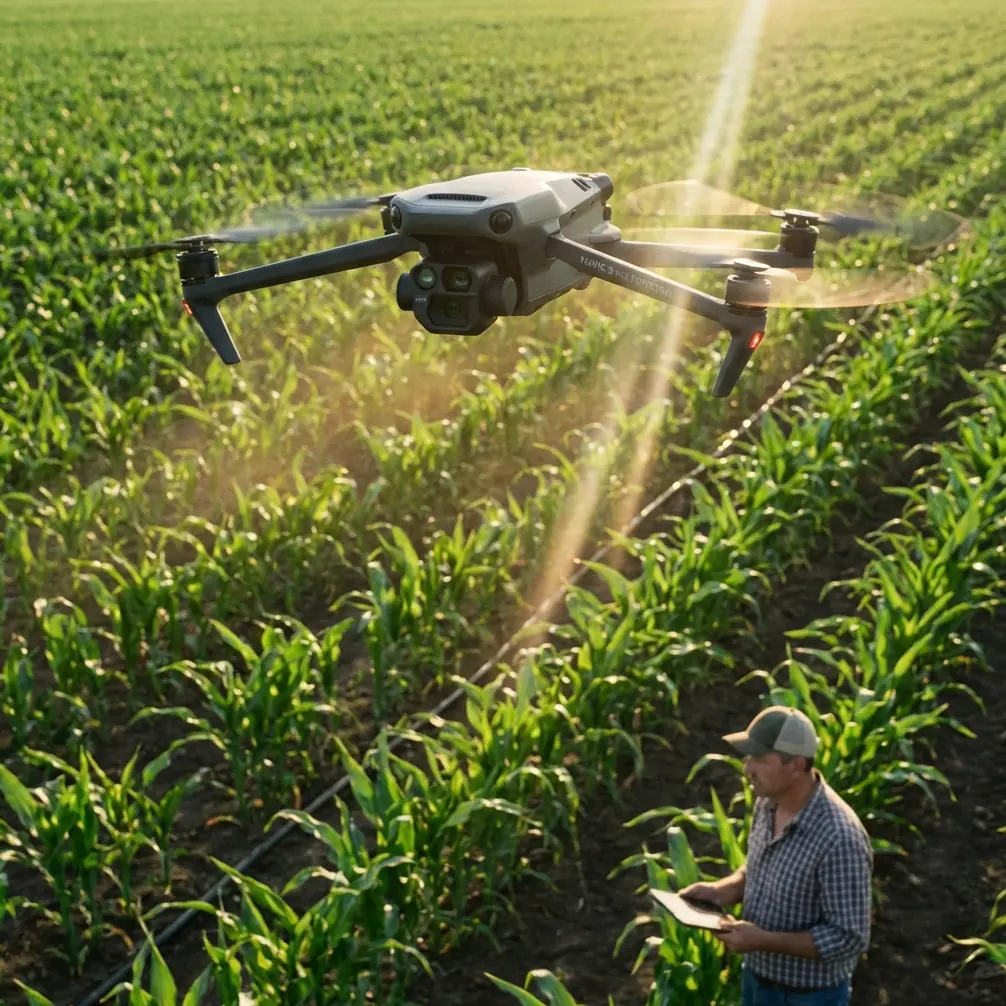
Urban forest monitoring sounds simple until the aircraft is actually in the air.
Trees sit beside reflective glass, transmission lines, rooftops, traffic corridors, and dense Wi-Fi noise. The mission is not just to capture multispectral imagery. The real job is to come home with data that is stable enough to compare over time, precise enough to trust, and clean enough to support decisions about canopy health, irrigation stress, replanting priorities, or disease spread.
That is where the Mavic 3M becomes interesting. Not because it is merely a multispectral drone, but because it sits at the intersection of portability and measurement discipline. In urban forestry work, that balance matters. You often need to move between narrow sites, launch from constrained clearings, and maintain repeatable coverage over trees that are broken up by roads, buildings, and utility infrastructure. A bulky platform can be awkward. A lightweight platform without precise positioning can be misleading. The Mavic 3M is useful when the operator respects both sides of that equation.
I approach this as a consultant’s workflow, not a brochure.
Why urban forest monitoring is harder than open-field crop mapping
In agriculture, broad acre fields give you room. In a city, the canopy is fragmented. One block may include tall plane trees, parked vehicles, steel fencing, lamp posts, glass façades, and overhead conductors. Those objects do not just affect pilot comfort. They influence GNSS reception, introduce multipath error, and can make an RTK Fix rate less stable than expected.
If you are trying to produce centimeter precision maps for change detection, a weak or inconsistent fix is not a minor annoyance. It changes how confidently you can compare one survey against another. If your urban forestry program is tracking crown thinning, moisture stress, or a replanting campaign over several months, positional consistency is part of the biological story.
That is why I never begin an urban Mavic 3M mission by thinking only about vegetation indices. I begin by thinking about the RF environment.
Start with the interference map, not the flight map
The biggest mistake I see in urban tree monitoring is treating antenna position as an afterthought. Operators plan the route perfectly, then stand in the worst possible place to support the link.
The fix is surprisingly physical. Before takeoff, walk the launch area and look for the sources most likely to distort the session:
- metal roof edges
- communications cabinets
- power lines
- rooftop HVAC clusters
- reflective curtain-wall glass
- parked service vehicles with antennas
- dense clusters of APs near public buildings
On paper, these may seem unrelated to a forest mission. In practice, they can shape link quality and GNSS behavior enough to reduce the value of the survey.
For the Mavic 3M, antenna adjustment should be treated as an operational input, not just a comfort tweak. The goal is not magical signal boosting. The goal is maintaining the cleanest practical geometry between controller and aircraft while avoiding your own body, nearby vehicles, or metallic surfaces from becoming part of the problem.
My rule in urban canopy work is simple: if I need to rotate my torso repeatedly to keep signal quality happy, my launch position is probably wrong.
Move first. Fly second.
A practical preflight sequence for urban canopy missions
I use a five-step sequence that keeps the mission grounded in data quality.
1. Evaluate the site for EMI and obstruction
Stand at the intended takeoff point and scan above roofline level. If the route passes near obvious sources of interference, consider shifting the launch point by even 10 to 20 meters if that opens cleaner line-of-sight.
This sounds trivial. It is not. In urban work, small relocations can dramatically improve link stability and reduce the likelihood that a building edge or metallic structure interferes with controller-aircraft geometry.
2. Confirm RTK behavior before committing to the mission
Do not assume the badge “RTK” guarantees perfect field conditions. Watch the Fix status settle. In a city, the RTK Fix rate is a real-world indicator of whether the site is cooperating. If it is fluctuating before launch, your map may still be visually attractive but less dependable for repeatable analysis.
Centimeter precision only matters if you actually achieve and maintain it.
3. Set a repeatable flight block
For urban forest monitoring, consistency usually beats aggressive coverage. Keep altitude, overlap, speed, and timing disciplined so your time-series comparisons remain meaningful. A beautiful one-off dataset has limited value if the next mission cannot match it.
4. Review antenna orientation during the climb
As the aircraft gains height, do a quick sanity check on your own posture and controller orientation. If signal performance improves just by turning away from a parked truck or stepping clear of a steel railing, that is evidence the local environment is active enough to deserve respect.
5. Watch the first pass like a systems test
Do not mentally leave the flight after takeoff. The first leg tells you whether the route, RF environment, and positioning solution are aligned. If not, abort early and reset. Losing three minutes is cheaper than collecting a low-confidence block.
What urban foresters should care about in multispectral missions
A multispectral dataset is only as useful as the consistency behind it. In city forestry, you are often trying to answer questions that are subtle:
- Which street trees show early stress before visible decline?
- Are newly planted sections establishing evenly?
- Is moisture variability following hardscape patterns?
- Is pest pressure emerging in isolated clusters?
The Mavic 3M is well suited to this because multispectral imagery can reveal changes that standard RGB review may miss. But interpretation gets shaky when position drift, inconsistent light conditions, or interrupted geometry contaminate the baseline.
That is why I tie multispectral discipline to positioning discipline. Operators sometimes treat them as separate topics. They are not. When a dataset is spatially inconsistent, the biological conclusions become less defensible.
The educational drone lesson that still applies here
One of the reference materials I was given had nothing to do with urban forestry on the surface. It came from a DJI TT educational drone document. Yet buried in it is a lesson professionals should not ignore.
The document describes a 5-second countdown sequence where the LED turns green and the display shows “5, 4, 3, 2, 1” before a throw-launch style exercise. It also includes a posture-detection concept: when pitch and roll angles fall within a narrow range, the aircraft recognizes that condition and changes behavior. Another exercise uses rotational attitude to show cardinal directions like E, S, W, and N on a dot-matrix display.
That may sound like classroom material. Operationally, it matters because it reinforces something many commercial pilots forget under pressure: aircraft behavior depends on state awareness, orientation, and disciplined triggers. In urban Mavic 3M work, you are not literally using a classroom countdown or a dot-matrix compass. But the same principle holds. Good missions are built from deliberate state checks: attitude confidence, orientation confidence, countdown discipline, and clear go/no-go thresholds.
The five-second teaching exercise is a useful mental model. Before each urban mission leg, ask: if I had only five seconds to verify readiness, what would I check? My answer is usually this:
- RTK status stable
- Antenna orientation clean
- Initial heading unobstructed
- Light conditions acceptable
- First turn clear of reflective or metallic clutter
Simple. Effective.
Why antenna adjustment deserves more attention in cities
The phrase “adjust the antennas” is often handed out as shallow advice. Let’s make it specific.
In an urban forest survey, antenna adjustment matters because the signal path is constantly threatened by obstacles and reflections. Trees themselves are usually not the hardest part. Buildings are. The challenge is not just direct blockage. It is also the messy environment created by urban surfaces that reflect energy unpredictably.
If you launch next to a metal structure, stand behind a vehicle, or face the wrong way while the aircraft transitions beyond a roof edge, you may notice intermittent drops in confidence or responsiveness. The answer is often not to push through. It is to stop and improve geometry.
That can mean:
- stepping away from a steel fence
- changing controller angle
- repositioning to keep line-of-sight through a cleaner corridor
- relocating launch to reduce rooftop masking
- avoiding body-blocking the controller path during the first outbound leg
These small choices have outsized effects on repeatable survey quality.
What a drone racing headline tells us about pilot culture
The recent report about the world drone competition opening with top pilots gathered and a high-energy atmosphere is easy to dismiss as unrelated to commercial work. I disagree.
A competition environment highlights one enduring truth: elite drone performance starts with control discipline, not hardware mythology. Skilled pilots read space, anticipate constraints, and manage orientation intuitively. That mindset translates directly to urban Mavic 3M monitoring.
No, you should not fly a forestry survey like a race. But you should borrow the professional instinct behind high-level drone performance: read the environment before it forces a correction. Urban interference management is mostly anticipatory. The best operators see problems before the telemetry fully complains.
Don’t let agricultural vocabulary distort an urban mission
Some of the common industry language around drones comes from agriculture: spray drift, nozzle calibration, swath width. For Mavic 3M forestry work in a city, two of those ideas still help, even though this is not a spraying operation.
Swath width matters because your effective coverage has to be consistent if you want usable mosaics and repeatable analysis. Think of it less as a sprayer concept and more as corridor discipline. Your imaging passes should be planned so the canopy is sampled evenly, especially where tree lines are interrupted by roads or structures.
Nozzle calibration, in spirit, becomes sensor-and-workflow calibration. The lesson is that field outputs are only trustworthy when the system is behaving predictably. In spraying, that means liquid delivery. In multispectral forestry, it means the aircraft, positioning, mission geometry, and data collection process are all controlled well enough that the map means what you think it means.
Spray drift is a reminder that urban environments create cross-influences. In a city survey, that “drift” may not be liquid movement. It may be RF contamination, reflected light, or alignment inconsistency creeping into the project. Different mechanism, same operational caution.
Building a repeatable monitoring routine
For municipalities, arborists, campus managers, and environmental consultants, the real value of the Mavic 3M is not the first flight. It is the fifth and fifteenth flight. Urban forest monitoring pays off when the methodology is stable enough to reveal trends.
A workable routine looks like this:
- launch from the same or functionally equivalent position whenever possible
- record interference notes for each site visit
- monitor RTK Fix behavior before each mission
- document any antenna adjustments that materially improved link quality
- keep mission timing and altitude consistent across survey dates
- compare anomalous canopy results with known environmental conditions on the ground
When that routine is followed, multispectral outputs stop being “interesting images” and start becoming management evidence.
One field note that saves headaches
If a site repeatedly produces unstable results, do not always blame the drone. Urban forestry missions often fail upstream. The launch area is poor, the route crosses too close to reflective structures, or the operator insists on standing where the controller has a compromised path.
When I train teams, I tell them to troubleshoot the site as aggressively as they troubleshoot the aircraft. If you want a second set of eyes on a difficult urban canopy workflow, send your site notes here: message Marcus directly on WhatsApp.
The bottom line for Mavic 3M in urban forest monitoring
The Mavic 3M is genuinely useful for urban forestry, but only when the operator treats positioning, orientation, and interference management as part of the sensing system.
Two details from the reference materials illustrate the point well. First, the educational DJI TT document’s 5-second countdown and attitude-based state logic show that drone operations are strongest when conditions are checked deliberately rather than assumed. Second, the drone race report reminds us that high-level performance comes from situational control and environmental reading, not just equipment.
In practical terms, that means this: if your RTK Fix rate is unstable, your antenna geometry is poor, or your launch point is contaminated by electromagnetic clutter, the multispectral mission is already compromised before the first map is built.
Urban forests deserve better than convenient data. They need reliable data.
Ready for your own Mavic 3M? Contact our team for expert consultation.