Mavic 3M for Forest Monitoring in Low Light
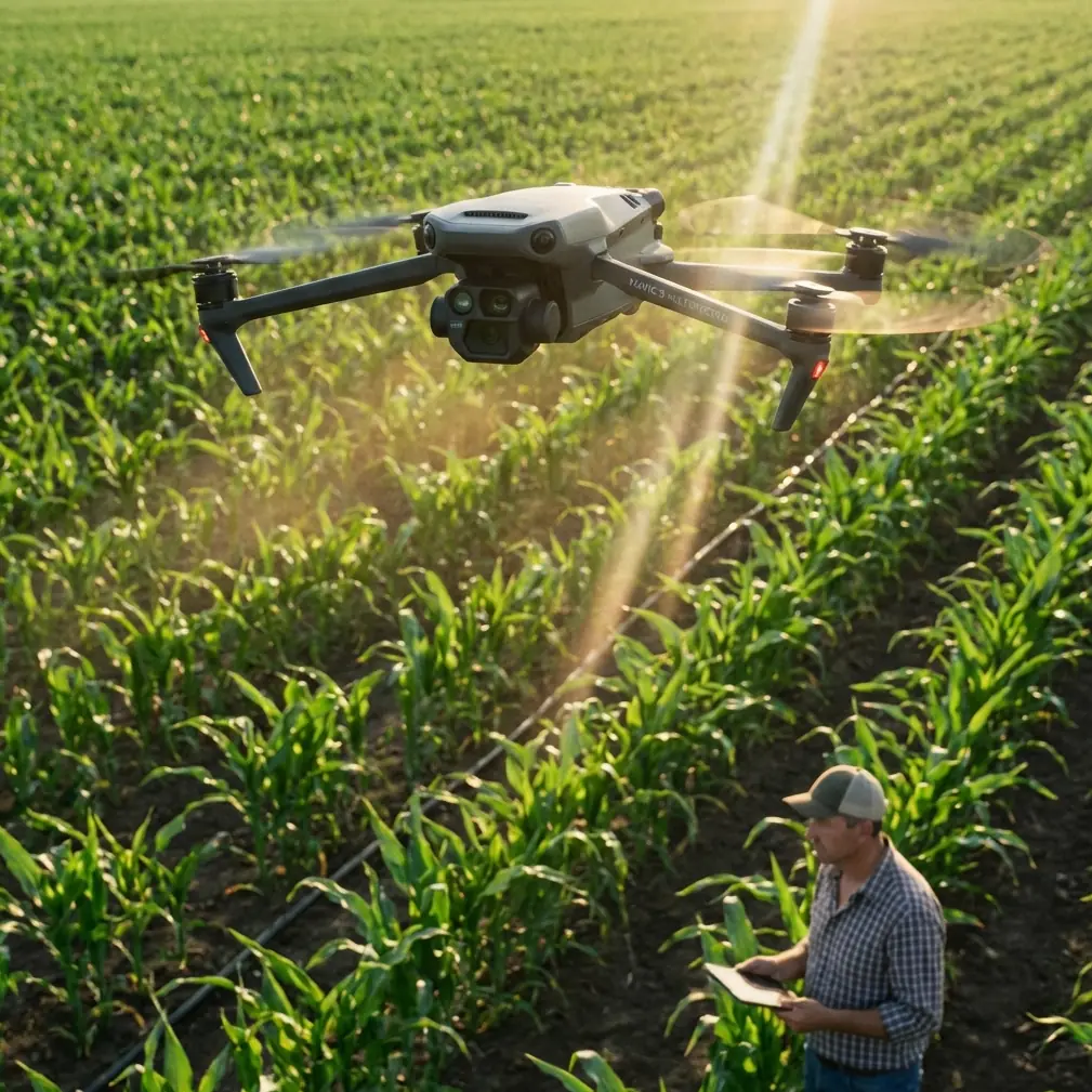
Mavic 3M for Forest Monitoring in Low Light: What Actually Matters in the Field
META: A technical review of the DJI Mavic 3M for low-light forest monitoring, with practical insight on multispectral use, RTK precision, workflow limits, and accessory choices that improve results.
Forest monitoring looks simple on paper until light disappears under a closed canopy.
That is where the Mavic 3M becomes interesting. Not because it turns night into day, and not because it solves every woodland survey problem, but because it sits at a useful intersection of portability, multispectral capture, and repeatable positioning. For consultants, estate managers, ecological survey teams, and forestry operators working in dim conditions at dawn, dusk, or beneath dense tree cover, that mix can be more valuable than outright payload size.
I have been thinking about the Mavic 3M in a broader industry context as well. At the 2026 Low-Altitude Industry Development Conference in Hengqin, multiple cooperation projects were signed, and the message from AVIC leadership was clear: the low-altitude economy is being treated as a strategic development direction, with emphasis on technology innovation, industry cultivation, and ecosystem building. That matters for a product like the Mavic 3M. It signals that forest monitoring is no longer a niche drone application operating at the margins. It is part of a larger push toward practical civilian aerial infrastructure, where mapping, environmental management, and data-led land operations are expected to become more structured and scalable.
For people considering the Mavic 3M specifically for low-light forest work, the right question is not “Is this the best forestry drone?” The better question is: “Under what conditions does this aircraft produce reliable, decision-grade information?”
The real challenge: forests compress light and distort data
Anyone who has mapped cropland in open sunlight and then moved into woodland notices the change immediately. In a forest, shadows are layered, contrast is unstable, and the canopy itself blocks both optical clarity and positional confidence. You are not only fighting lower illumination. You are dealing with constantly shifting reflectance.
That makes sensor behavior more important than headline specifications.
The Mavic 3M’s value in this setting comes from two traits that work together:
- Multispectral capture for vegetation analysis
- RTK-enabled repeatability for comparing flights over time
Multispectral data matters because visual imagery alone can be misleading in dim woodland scenes. In low light, RGB images can make healthy and stressed vegetation look more similar than they are, especially when moisture, shadow angle, and mixed canopy density are involved. Multispectral imaging gives the operator a better chance of separating actual plant-condition patterns from lighting artifacts.
The second trait, repeatable positioning, is just as important. If you are tracking disease spread, regeneration success, invasive species pressure, storm damage, or moisture-related stress, consistency between one mission and the next often matters more than a single beautiful map. A high RTK fix rate and stable georeferencing workflow support that consistency. In practical terms, centimeter precision is not about bragging rights. It is about being able to revisit the same corridor, stand edge, or sample block and trust that changes in the map reflect the forest, not your flight alignment.
Why low-light operations change how you should use the Mavic 3M
Low light pushes every weak point in an aerial workflow to the surface.
With the Mavic 3M, that means you need to think less like a casual drone pilot and more like a remote sensing operator. The aircraft is compact, but the mission design cannot be casual. Forest monitoring in dim conditions rewards discipline in four areas:
1. Flight timing
The best low-light window is not always the darkest acceptable window. In forests, early morning often offers calmer air and more stable moisture conditions, but if the light is too flat or too weak, image quality and feature definition suffer. Late afternoon can work well if glare is controlled and wind remains manageable.
The point is to aim for consistent low-light conditions, not merely minimal light. Repeatability is what makes change detection credible.
2. Canopy geometry
Swath width on paper can tempt operators to fly high and cover ground quickly. In forests, that can be a mistake. A wider swath width may look efficient, yet it often reduces the practical usefulness of imagery under mixed canopy heights and irregular stand structure. Lower altitude with stronger overlap usually produces a cleaner orthomosaic and better edge interpretation around crowns, trails, drainage lines, and stressed pockets.
3. RTK behavior under obstruction
RTK performance in open fields and RTK performance near tall timber are not the same thing. A dense canopy edge, valley topography, and signal masking can all reduce confidence in the fix. This is where RTK fix rate becomes an operational metric rather than a setup detail. If your fix quality is unstable, your before-and-after analysis becomes less trustworthy, especially in narrow forest roads, riparian strips, or compartment boundaries.
4. Ground truthing
Multispectral outputs are powerful, but forests remain messy biological systems. A vegetation index anomaly might indicate stress. It might also reflect species mix, shadow density, soil moisture variation, or understorey exposure. The Mavic 3M works best when flight data is tied back to field inspection rather than treated as a stand-alone verdict.
The accessory that makes a bigger difference than many expect
One third-party addition I have seen improve forest results is a high-visibility strobe accessory designed for twilight operations and visual aircraft tracking. This does not increase sensor sensitivity, and it does not change the multispectral data itself. What it improves is operational control.
In low-light woodland flying, maintaining visual orientation can become more difficult than people expect, especially over uneven terrain or against dark tree lines. A quality external strobe helps the pilot retain line-of-sight awareness during repositioning, edge passes, and return segments. That reduces pilot workload, which in turn supports more disciplined mission execution. Cleaner mission execution usually means better overlap, fewer hurried adjustments, and fewer flawed datasets.
This is a good example of how real-world capability often comes from workflow refinement rather than from the aircraft alone.
Where the Mavic 3M fits in the low-altitude economy discussion
The news from Hengqin is not just policy theater. When a major industry conference gathers around low-altitude development, signs multiple cooperation projects, and highlights technology innovation plus ecosystem building, it points to a more mature service environment for drones used in civilian sectors.
For Mavic 3M operators, that has operational significance in at least two ways.
First, ecosystem building means the value of a drone increasingly depends on the support around it: data processing workflows, interoperability, training standards, maintenance access, and specialized accessories. Forest monitoring is rarely solved by hardware alone. A stronger industry ecosystem makes it easier for operators to move from occasional flights to a repeatable monitoring program.
Second, industry cultivation matters because forestry and environmental monitoring need long time horizons. A woodland health program may run season after season. If low-altitude infrastructure is treated as a serious development direction, teams using aircraft like the Mavic 3M benefit from a more stable environment for partnerships, data services, and technical support. That is particularly relevant for consultants managing multiple client sites or large distributed land assets.
This is why the strategic comments at the conference deserve attention. When leadership frames low-altitude industry as a national development direction and emphasizes the role of central enterprises in scientific innovation and ecological construction, it reinforces something field operators already know: aerial data is becoming part of mainstream operational management, not an experimental add-on.
Multispectral in forests: useful, but only if you respect the limits
The Mavic 3M’s multispectral capability is the feature that draws most interest, and understandably so. In woodland work, it can help identify stress gradients that are hard to read in ordinary imagery. It is especially useful for:
- tracking regeneration vigor after replanting
- monitoring storm-affected stands
- spotting drainage-related stress patterns
- evaluating pest or disease spread corridors
- comparing shaded and exposed stand edges over time
Still, low-light forest use adds a caution: multispectral interpretation under dense canopy is not the same as interpretation over uniform crops. Tree height differences, mixed species composition, understorey complexity, and crown layering all complicate the signal.
This is why experienced users care about consistency more than one-off dramatic maps. Fly the same blocks with the same parameters. Control altitude carefully. Keep overlap conservative. Watch RTK status. Log weather. Then compare.
That is how the Mavic 3M earns trust.
What about the agriculture-focused terms people keep searching?
Some search behavior around the Mavic 3M overlaps with spray-platform topics, so terms like spray drift, nozzle calibration, swath width, and IPX6K show up in the same research journey. For forest monitoring buyers, this can muddy product selection.
The distinction is simple. The Mavic 3M is a sensing platform, not a spraying aircraft. So spray drift and nozzle calibration are not direct operating concerns for this model. Their relevance is indirect: many forestry teams compare sensor drones with application drones when planning broader vegetation-management programs. In that comparison, the Mavic 3M often sits upstream in the workflow. It helps identify where intervention may be needed, document baseline conditions, and measure change after treatment.
Swath width, however, remains very relevant because mission efficiency still matters in mapping. The mistake is treating swath width as the main metric. In low-light forests, usable data quality should dominate planning decisions.
As for IPX6K, it belongs to a different class of ruggedization expectation than what most compact mapping drones are built around. Forest operators working in mist, fine drizzle, or humid dawn conditions should understand that portable survey aircraft and heavy-duty application platforms are engineered for different environments. Do not confuse product categories. The Mavic 3M is strong where rapid deployment, high-quality sensing, and efficient area coverage matter. It is not a substitute for a weather-hardened spraying system.
Best-practice workflow for low-light forest missions
If I were advising a team deploying the Mavic 3M in this role, I would keep the workflow tight:
- Fly repeated missions at nearly the same time of day.
- Prioritize RTK stability over raw speed.
- Use moderate altitude instead of chasing maximum coverage.
- Increase overlap when canopy complexity rises.
- Validate suspicious zones on foot.
- Use a third-party visibility strobe if twilight operations are common.
- Archive mission notes with environmental conditions, not just imagery.
If your organization is building a repeatable woodland monitoring program and wants to compare setup options or field accessories, a direct technical conversation often saves time more than another spec-sheet pass: message a Mavic specialist on WhatsApp.
Final assessment
The Mavic 3M is not magic in low-light forests. That is exactly why it deserves a serious look.
It offers a practical combination of multispectral sensing, compact deployment, and repeatable positioning that suits forestry teams who need frequent, structured observation without moving into a larger and more complex aircraft class. Its strength is not brute force. Its strength is disciplined repeatability.
The broader industry signals coming out of the 2026 Hengqin conference support that reading. With low-altitude development being pushed through cooperation projects, technology innovation, and ecosystem building, aircraft like the Mavic 3M are becoming part of a more credible operational stack for environmental management. That is good news for anyone trying to turn drone flights into a long-term monitoring system rather than a collection of isolated missions.
For forest work in low light, the aircraft performs best when expectations are realistic: use multispectral data to reveal patterns, use RTK to hold your comparisons together, and use mission discipline to reduce noise. Add one smart accessory that improves pilot control, and the whole system becomes more dependable.
That is the difference between owning a capable drone and running a reliable monitoring program.
Ready for your own Mavic 3M? Contact our team for expert consultation.