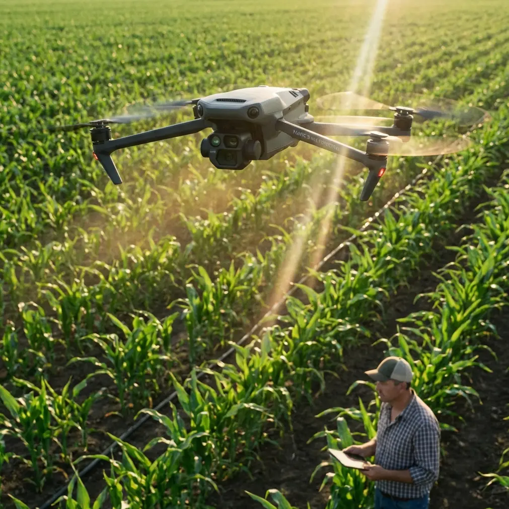
Monitoring Mountain Fields With the Mavic 3M
Monitoring Mountain Fields With the Mavic 3M: Practical Tips That Actually Shorten the Learning Curve
META: Learn how to use the DJI Mavic 3M for mountain field monitoring with practical tips on multispectral workflow, RTK discipline, battery management, and why in-person practice accelerates results.
Mountain agriculture exposes every weakness in a drone workflow.
Flat test plots are forgiving. Hillsides are not. Light shifts faster, wind behaves differently across ridgelines, access is awkward, and battery planning becomes less theoretical the moment your landing spot is a narrow terrace instead of an open field. That is why the Mavic 3M tends to reward operators who learn in the field with other people, not just through manuals and isolated trial-and-error.
A recent photography article published on 2026-04-25 made a point that translates surprisingly well to drone crop monitoring: beginners often memorize settings, experiment alone, and still feel lost. The argument was simple. Skill improves faster through observation, borrowing what works, and talking with peers during offline activities. For Mavic 3M users in mountain farming, that advice is more than motivational. It is operationally useful.
The drone can be technically excellent, but the quality of the mission still depends on judgment: where to launch, when to fly, how to maintain RTK Fix rate on uneven terrain, how to preserve overlap across broken slopes, and how to interpret multispectral variation without fooling yourself. Those things are learned fastest when someone experienced can point at a ridge, a shadow line, or a weak GNSS patch and explain what will go wrong before it does.
Why mountain monitoring is different with the Mavic 3M
The Mavic 3M is often discussed for its multispectral capability, and rightly so. But in mountain fields, the headline feature is only half the story. Elevation changes and fragmented plots can turn a clean mapping plan into inconsistent data if the operator treats every field like a flat rectangle.
This is where centimeter precision matters. On sloped agricultural land, small positional errors can affect alignment across repeated missions, especially if you are comparing crop stress patterns over time. If your RTK Fix rate is unstable, your map may still look acceptable on first inspection, but repeated surveys become harder to trust. That matters when you are trying to distinguish real plant response from data noise.
The same goes for swath width. On paper, a broader swath sounds efficient. In mountain terrain, actual effective coverage can shrink because slopes change relative sensor-to-crop geometry. One side of the flight line may be closer to canopy than the other. If you rely on idealized planning assumptions, overlap can become inconsistent at the exact points where you need clean data the most.
Multispectral output is powerful here, but only when collected with discipline. A mountain field is a patchwork of angle, moisture, shadow, exposure, and wind. The Mavic 3M gives you better visibility into that variability, but it does not automatically interpret it for you.
The fastest path is not solo flying
The 2026 article’s core claim was that people who only study parameters and compose images alone often plateau. The drone equivalent is familiar. New operators read manuals, memorize menus, and run missions in isolation. They can launch, map, and export files. Yet their results remain inconsistent, and they do not always know why.
For mountain-field monitoring, offline group practice is one of the smartest accelerators available.
Why? Because many of the real problems are visible only in context.
An experienced pilot can show you why your chosen takeoff point is creating weak signal geometry. A crop consultant may explain that the “anomaly” you marked is actually irrigation pattern, not stress. Another operator may point out that your mission timing creates long terrain shadows that contaminate interpretation. These lessons are hard to derive from screen-based learning alone.
The source article specifically argued that beginners improve faster by joining offline activities, exchanging ideas with peers, avoiding common mistakes, and gaining confidence through shared practice. Applied to the Mavic 3M, that means local flight days, orchard and hillside demonstration sessions, and shared post-processing reviews are not optional extras. They are one of the shortest routes to useful data.
If you are building a monitoring routine for mountain fields, schedule at least one real-world session with other operators before you decide your workflow is “good enough.” You will likely save weeks of avoidable error.
Start with terrain, not settings
One of the most common beginner habits is to obsess over settings before understanding the site. The photography article criticized the tendency to memorize technical parameters while remaining unsure why the final result still feels off. In mountain drone work, this mistake is even more costly.
Before touching mission settings, walk the field edge if possible and answer five questions:
- Where is the safest launch and recovery zone?
- Which slopes will create the strongest lighting contrast during the planned flight window?
- Where are the obstacles that matter from above, not just from ground view?
- Which sections are likely to lose line-of-sight or weaken positioning?
- Which subplots should be surveyed as separate blocks rather than forced into one mission?
This site-first habit changes everything. It helps preserve RTK stability, improves overlap logic, and prevents rushed battery decisions later.
If your field is broken into terraces, resist the urge to combine them just because the software can draw one clean polygon. Multiple smaller missions often produce more dependable results than one overextended flight that struggles with terrain transitions.
A battery management tip from real field work
Battery mistakes in mountain agriculture rarely happen because the operator forgot to charge. They happen because the operator underestimates how much terrain steals margin.
My standing rule for the Mavic 3M in mountain plots is simple: never let the outbound leg consume the confidence you need for the return climb and landing setup. In practice, that means watching not just battery percentage, but where and how that percentage is being used.
Here is the field tip I teach most often: if the aircraft reaches the farthest edge of a mountain field and the battery is already lower than your normal flat-land turning threshold, end the mission segment early and restart from a closer launch point. Do not trust a “probably fine” return over uneven terrain.
Why this works:
- Climbing back toward a higher landing zone can consume more energy than expected.
- Wind at ridge level may be stronger on the way home than it was during the outbound leg.
- Mountain fields often force a more careful final approach, which adds hover and reposition time.
- Cold mornings at elevation can change battery behavior enough to matter.
A practical routine is to rotate batteries by mission complexity, not just flight order. Use your freshest pack for the most fragmented or highest-elevation block, not automatically for the first flight of the day. Labeling batteries and keeping notes on how each one performs under hillside conditions is a small habit with outsized value.
If you want to compare battery behavior, mission planning choices, or hillside workflow with someone who works with these systems regularly, you can message our field support contact here.
How multispectral data becomes trustworthy in mountain fields
The word “multispectral” attracts attention because it promises a layer of crop visibility beyond standard visual inspection. In mountain farming, that promise is real, but the margin for misreading data is wider than many expect.
The trap is assuming every variation in the map reflects plant health alone. On sloped land, light angle and terrain geometry can create differences that look agronomic but are partly environmental. That is why repeated mission consistency matters so much.
For the Mavic 3M, consistency should include:
- Similar time-of-day windows across repeat surveys
- Similar flight altitude relative to crop canopy
- Stable RTK behavior
- Comparable weather and wind conditions where possible
- A clear separation between truly distinct field blocks
The operational significance is straightforward. If you are comparing one hillside mission against another, you need confidence that changes in the data reflect the field, not your method. Otherwise, intervention decisions become guesswork.
This also matters when evaluating issues related to spray drift. Drift can create irregular stress patterns along slope edges or boundary zones, but so can shadow, runoff, or localized exposure differences. A clean multispectral map is useful only when paired with field observation and a realistic understanding of the terrain.
RTK discipline is not optional on slopes
Mountain plots expose sloppy positioning habits quickly. Flat areas can hide moderate inconsistencies. Slopes do not.
A strong RTK Fix rate supports repeatability, especially when the goal is to monitor the same vines, rows, or terraces over time with centimeter precision. If your fix quality degrades, you may still complete the mission, but downstream comparison becomes weaker. In practical terms, that can blur whether a pattern is stable, spreading, or newly emerging.
I advise operators to treat RTK health as part of preflight go/no-go logic, not just a status icon. If the terrain or surrounding obstruction makes stable fix performance doubtful, change your launch location or break the mission apart. Data you can trust from two smaller flights is better than one elegant but compromised survey.
What mountain operators can learn from photography groups
This may sound sideways, but the photography article’s advice about offline learning fits drone operations unusually well.
Photography beginners often improve when they stop working in a vacuum. They see how others frame scenes, adapt to light, and solve problems in real time. The same is true for Mavic 3M pilots. Watching a capable operator plan around a mountain field teaches things no checklist can fully convey: pacing, restraint, route logic, and when to abandon an overambitious plan.
A shared field session also makes post-flight review sharper. Someone else may immediately spot that your overlap dipped near a ridge, or that your chosen window introduced too much shadow for reliable comparison. Those corrections are often obvious in conversation and invisible when you are reviewing your own work alone.
For training teams, this suggests a better model than remote instruction only. Use short theory sessions, then move quickly into live hillside exercises. Let trainees compare results from different launch points and flight timings. Discuss what changed and why. That is how competence becomes repeatable.
Don’t ignore adjacent spray workflow factors
The Mavic 3M is a monitoring platform, not a sprayer, but it often sits upstream of crop treatment decisions. That means a few adjacent concepts matter.
For example, nozzle calibration is not a flight setting for the aircraft, yet understanding whether poor crop performance aligns with application inconsistency can completely change how you read a multispectral map. The same applies to spray drift. In mountain terrain, drift behavior can be influenced by slope-driven airflow and changing wind channels. If a stress pattern appears along exposed edges, your interpretation should include treatment history, not only plant physiology.
The operational lesson is simple: monitoring flights become more valuable when the pilot understands the farm system around them. The better your context, the less likely you are to overread the imagery.
Weather resistance changes the working day, not the rules
The mention of IPX6K often encourages confidence in rough field conditions, and that confidence has a place. In mountain agriculture, where moisture, dust, and variable conditions are routine, robust hardware matters.
But durability should support discipline, not replace it. Weather-tolerant design helps the Mavic 3M stay practical in demanding agricultural environments, yet mountain operators still need to respect changing visibility, wind acceleration near ridges, and wet landing surfaces. The aircraft may be ready for a difficult day. The mission still has to make sense.
A simple training framework for mountain Mavic 3M work
If you are new to monitoring fields in hilly terrain, use this progression:
1. Observe one experienced mission in person
Do not fly first. Watch site assessment, launch-point choice, and terrain discussion.
2. Run a small block, not a whole farm
Pick one terrace or one hillside segment. Focus on repeatability.
3. Review data with someone else
Ask what parts of the result are agronomic and what parts may be terrain effect.
4. Repeat the same block under similar conditions
This builds interpretive confidence faster than constantly changing locations.
5. Keep a battery and RTK log
Track which batteries perform best in cooler or higher sites and note where fix quality weakens.
This framework closely echoes the 2026 article’s argument that beginners improve faster by combining practice with observation and exchange. That is not soft advice. For Mavic 3M mountain operations, it is a hard productivity advantage.
The drone can gather excellent information. The operator determines whether that information becomes actionable. And on mountain fields, the shortest route to that level is usually not more solo guessing. It is better field habits, shared learning, and a workflow built around terrain reality rather than menu familiarity.
Ready for your own Mavic 3M? Contact our team for expert consultation.