Mavic 3M in a Tighter Drone Era: What China’s New Rules
Mavic 3M in a Tighter Drone Era: What China’s New Rules Mean for Remote Field Monitoring
META: A field-focused case study on how stricter drone regulation and large-scale public drone displays reshape practical Mavic 3M operations for remote crop monitoring.
For agriculture teams using the Mavic 3M far from town centers, the latest shift in China’s drone environment matters more than many hobby headlines suggest. The headline event was spectacular: 22,580 drones rising together over Hefei, drawing Huizhou-style architectural forms across the night sky for a Spring Festival Gala audience counted in the hundreds of millions. But the more consequential development for day-to-day operators is less cinematic. Starting January 1, 2026, unauthorized flying is explicitly treated as an act endangering public safety, with penalties reaching up to 15 days of detention.
Those two facts belong in the same conversation.
One shows how mature the drone sector has become. The other shows that regulators now expect the same maturity from operators. For Mavic 3M users working in remote agricultural blocks, that combination changes the operating mindset from “Can I launch here?” to “Can I document, justify, and repeat this mission safely and cleanly?”
That is a healthy shift, especially for serious crop monitoring.
A Practical Reading of the News for Mavic 3M Operators
The public tends to see drones in two categories: entertainment and risk. The Hefei show pushes the first category to a new scale. A coordinated launch of 22,580 aircraft is not just a visual record. It is a sign that airspace coordination, fleet synchronization, and public-facing drone operations are entering a more formal era. At the same time, the upcoming January 2026 rule draws a hard line under informal or unauthorized flights.
For an agricultural user, this is not just policy noise. It affects route planning, team training, insurance expectations, and the way evidence is gathered during every mission.
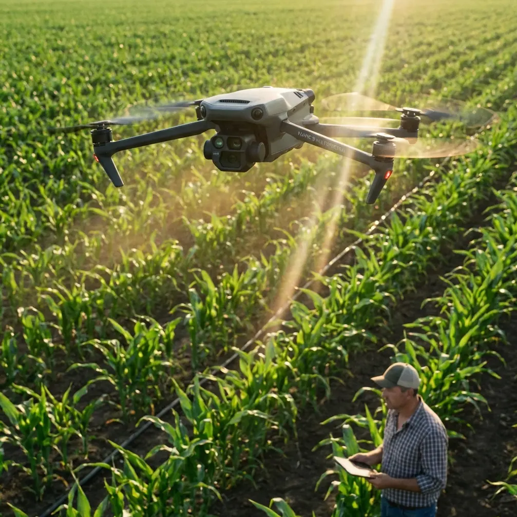
The Mavic 3M sits in an interesting position here. It is not a light recreational toy, and it is not a bulk-spraying platform either. It is a data aircraft. Its value comes from multispectral sensing, repeatable mapping, and the ability to build agronomic decisions from consistent imagery. When rules tighten, platforms with clear professional use cases tend to gain relative advantage. That is because their flights are easier to justify operationally. A crop scouting mission tied to stand counts, drainage assessment, stress detection, or treatment verification has a very different profile from casual flying.
In other words, the new environment rewards purpose.
Case Study: Remote Field Monitoring Under Stricter Airspace Expectations
I want to frame this through a realistic field scenario. Imagine a farming cooperative managing scattered parcels well outside the village core. Connectivity is patchy. Roads are inconsistent. The agronomy team needs to inspect several hundred hectares after a weather swing that may have triggered localized stress in low-lying sections. Sending staff row by row would consume a day or more. Satellite imagery is too coarse or too delayed for the management decision they need to make that week.
This is where the Mavic 3M earns its place.
The aircraft’s multispectral payload allows the team to compare visible conditions with plant response patterns that are easy to miss from the ground. In remote fields, that matters because crop issues often emerge unevenly. A grower may describe the problem as “the north side looks weak,” but the drone map often shows something more precise: a drainage line, a compaction strip, a delayed emergence zone, or a nutrient uptake boundary following soil variation rather than field geometry.
Yet the real lesson from the current news cycle is not simply “use a better sensor.” It is that professional field monitoring now needs professional flight governance.
Under the coming 2026 rules, informal habits become liabilities. That includes ad hoc launch points, poor mission logging, and weak preflight review. For remote operations, the safest pattern is to standardize every job: confirm the flight area, record the agricultural purpose, document local conditions, verify aircraft status, and save mission outputs in a way that supports later review. If an operation is ever questioned, the difference between a documented crop survey and a casual flight is not rhetorical. It is operational evidence.
Why the Hefei Drone Show Matters to Agriculture
At first glance, a giant gala performance seems unrelated to remote crop scouting. It is not.
A synchronized event involving 22,580 drones demonstrates something fundamental: drone use is becoming visible infrastructure. Once a technology reaches that level of scale and public attention, regulators, local authorities, and the general public stop treating it as a niche hobby. They start expecting standards, accountability, and predictable behavior.
For agricultural operators, that creates both friction and opportunity.
The friction is obvious. Access can become more controlled. Teams may need more formal approvals depending on location. Pilots must understand where they can and cannot fly, rather than relying on local custom or assumptions.
The opportunity is more strategic. As recreational or loosely managed flying comes under pressure, mission-driven work stands out more clearly. A Mavic 3M deployed for crop health analysis, drainage assessment, emergence evaluation, or treatment verification becomes easier to position as legitimate and necessary. In a market where some secondhand drone values have reportedly fallen by more than 20%, purpose-built operational use becomes a stronger differentiator than simple ownership.
That detail from the report should not be ignored. Falling recovery values on used platforms tell us confidence is being repriced. The market is moving away from speculative or impulse drone ownership and toward systems that justify themselves through outcomes. For agriculture, that is actually a constructive development. It favors aircraft that save scouting hours, improve intervention timing, and reduce unnecessary field passes.
What This Means Specifically for the Mavic 3M
The Mavic 3M is especially relevant in this environment because it helps answer the question regulators and farm managers both care about: what was the purpose of the flight, and what decision came from it?
A standard RGB camera can document appearance. A multispectral workflow can support interpretation. That distinction matters in remote fields where the agronomic signal is subtle.
Take a common scenario after uneven rainfall. From the road, the field may appear broadly fine. The Mavic 3M can reveal patterned stress across wheel tracks, irrigation distribution anomalies, or low-vigor pockets that justify a follow-up inspection. That prevents crews from wasting time across unaffected sections and helps prioritize the field zones that need boots-on-the-ground validation.
It also sharpens the conversation with input decisions. While the aircraft itself is not a spraying platform, its data directly informs application strategy. If a treatment flight is planned later with another system, Mavic 3M maps can reduce guesswork around target areas, drift risk discussions, and the practical swath boundaries operators should care about. Terms such as spray drift and nozzle calibration may sound unrelated to a mapping drone, but in real farm workflows they connect tightly. Better scouting reduces poorly targeted application, and poorly targeted application is often where both cost and agronomic damage accumulate.
This is where professional workflows become more valuable than ever. If airspace access grows more structured, each flight needs to return more decision value. The Mavic 3M’s role is not simply to “see the field.” Its role is to convert limited legal, logistical, and battery windows into actionable agronomy.
Battery Discipline in Remote Fields: A Tip That Saves Missions
Field experience tends to humble even technically strong teams. In remote monitoring, battery management is one of the quiet factors that decides whether a mission produces a clean dataset or an incomplete patchwork.
My standing rule is simple: do not chase the last few percentage points in a distant field. On paper, squeezing one more short pass from a battery can look efficient. In reality, it often produces the opposite result. A gust change, longer-than-expected return leg, or additional hover time during RTK reacquisition can turn a neat plan into a compromised landing.
A better habit is to assign one battery to one clearly bounded mapping objective whenever possible. In practice, that means defining the block size and swath plan before launch, rather than stretching flight time mid-mission. If the site is remote and temperatures are variable, keep batteries insulated during transport and let them stabilize before flight. Cold-soaked packs can sag faster than crews expect, especially when the aircraft climbs, accelerates into wind, or has to hold position during a delayed fix.
That leads to another operational point. If your workflow depends on centimeter precision, do not treat RTK fix rate as a background metric. Watch it. In remote fields, terrain, tree lines, local interference, or poor setup discipline can slow the transition to a stable solution. Launching too quickly before the positioning state settles may save two minutes and cost you much more in map consistency.
The discipline sounds mundane. It is not. In agriculture, boring reliability beats flashy improvisation every time.
Building a Defensible Monitoring Workflow
As regulations tighten, farm drone programs need a workflow that survives scrutiny. The easiest way to think about this is to treat each mission as if someone may later ask three questions: why did you fly, how did you fly, and what did you learn?
For Mavic 3M operations, that means:
- Define the agronomic purpose before arriving on site.
- Confirm the field boundary and any nearby airspace sensitivities.
- Verify aircraft health, battery condition, and payload settings.
- Check positioning quality if repeatable mapping is required.
- Keep outputs tied to field names, dates, and treatment history.
This is not bureaucracy for its own sake. It protects the value of the data. A multispectral map detached from context is just a colored surface. A map tied to field conditions, weather timing, past interventions, and follow-up observations becomes a management tool.
Remote operators often underestimate how much this improves team communication. A farm manager, agronomist, and pilot do not always use the same language. The drone dataset becomes the shared reference point. If you need help designing that kind of field-ready workflow, I’ve seen teams benefit from a quick operational review through this Mavic 3M planning chat.
The Bigger Market Signal
The source report describes a market that has felt like a roller coaster for enthusiasts. That is accurate, but agriculture should read the signal differently.
Tighter enforcement against unauthorized flying is likely to reduce casual misuse. Public mega-events such as the Hefei display show that drone capability is advancing at the top end. Between those poles, professional applications are being forced to grow up. That is exactly where crop monitoring belongs.
The strongest drone programs in agriculture over the next two years will not be the ones with the most flights. They will be the ones with the cleanest mission purpose, the best recordkeeping, and the most disciplined use of data. A Mavic 3M fits that direction well because it supports a repeatable sensing workflow rather than a novelty use case.
For remote field monitoring, that matters on the ground. Fewer wasted trips. Faster identification of stress zones. Better verification before treatment. More defensible records after the fact.
And perhaps most importantly, it aligns the farm team with where the sector is clearly headed: less improvisation, more operational rigor.
The drone market may indeed be getting “more interesting,” as the original headline suggests. But for serious Mavic 3M users, the interesting part is not the spectacle. It is the emergence of a more disciplined operating environment where professional agricultural missions can finally separate themselves from noise.
Ready for your own Mavic 3M? Contact our team for expert consultation.