Monitoring construction sites with Mavic 3M in windy conditi
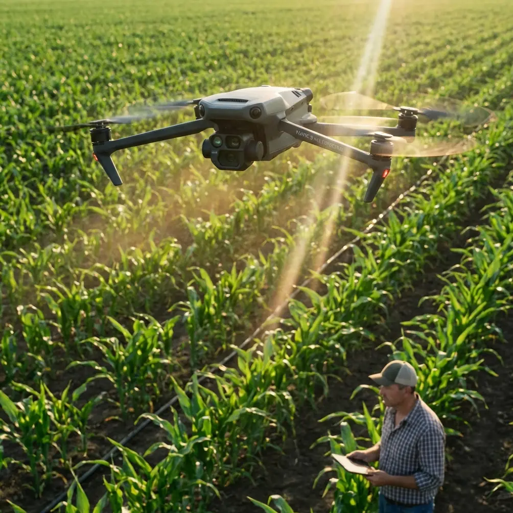
Monitoring construction sites with Mavic 3M in windy conditions: practical tips that actually hold up
META: A field-driven guide to using the DJI Mavic 3M for windy construction site monitoring, with practical advice on flight discipline, precision, multispectral value, and operator setup.
Wind changes everything on a construction site.
It shifts dust, moves loose materials, complicates safety oversight, and turns an easy drone survey into a session full of repeated passes, inconsistent overlap, and questionable data. I learned that the hard way on a grading project where the site itself was straightforward, but the wind was not. The visible-light captures looked acceptable at first glance. Then we compared them across days. Edges drifted. Repeatability suffered. Confidence dropped.
That was the moment I stopped thinking about site monitoring as “just fly and capture” and started treating it as a discipline of controlled inputs. For teams using the Mavic 3M, that mindset matters even more. This aircraft is often discussed for multispectral work, but on construction sites the real advantage is not simply that it can collect more data. It is that, when operated with care, it can help you produce more consistent data under less-than-ideal field conditions.
This article is about how to do that in wind.
Why windy construction sites expose weak operating habits
Many operators assume that if a drone is advanced, the workflow will be forgiving. In practice, the opposite is often true. Better aircraft reveal poor habits faster because they make you capable of collecting higher-grade information than your field process is actually prepared to support.
That pattern shows up in another imaging domain too. A recent piece about Huawei’s built-in XMAGE system made a sharp observation: many users buy phones with sophisticated imaging hardware, then avoid the “Professional” mode because the settings feel too technical, too abstract, too easy to get wrong. The result is familiar—expensive capability sitting idle while users settle for underwhelming output.
The same trap appears in drone operations. Teams buy a capable platform like the Mavic 3M, then fly it mostly on default assumptions. They avoid dialing in mission parameters because the details seem tedious or risky. In calm conditions, they may get away with it. On a windy construction site, they usually do not.
If your deliverable has to stand up to project managers, engineers, and repeat inspections, “good enough” is not stable enough.
The Mavic 3M advantage is not magic. It is disciplined repeatability.
For construction monitoring, the value of the Mavic 3M is not only the multispectral payload. It is the combination of precision-oriented workflow, repeatable capture logic, and site-wide context. Those are the ingredients that let you compare material stockpiles, erosion patterns, drainage behavior, disturbed ground, and progress zones across time without constantly wondering whether the aircraft path itself introduced the discrepancy.
That is why terms like RTK fix rate and centimeter precision matter operationally, even if your current job is not a pure survey contract.
On a windy site, maintaining strong positional consistency helps in three ways:
- It reduces ambiguity between actual site change and flight-path variation.
- It improves confidence in edge matching and temporal comparison.
- It limits the number of “we should probably re-fly that section” decisions.
When a superintendent wants to know whether runoff is worsening near a temporary haul road, or whether a newly disturbed slope is behaving differently after weather exposure, consistency matters more than dramatic imagery.
Start with the mission plan, not the aircraft
Wind punishes improvisation. Before launch, build the mission around the site’s actual constraints.
I recommend breaking the workflow into four checks:
1. Define the monitoring question
Do not fly for “general documentation” if the site is windy and time is limited. Decide what matters most:
- Earthwork progress
- Drainage and pooling
- Surface disturbance
- Perimeter compliance
- Temporary access roads
- Material storage zones
- Vegetation stress around disturbed edges
That last item is where multispectral can become especially useful. On construction sites, the Mavic 3M is not just about crop health. It can help identify subtle patterns in vegetated buffers, sediment-control zones, or site margins affected by runoff, dust deposition, or grading activity.
2. Match altitude to the needed detail and wind behavior
Higher altitude can improve efficiency by increasing swath width, but it also exposes the aircraft to stronger and less predictable air movement. Lower altitude often improves detail and reduces some wind effects, though at the cost of more passes and longer mission time.
There is no universal setting. The key is to avoid choosing altitude based purely on speed. In difficult wind, the “fastest” flight often becomes the slowest because you end up reflying sections.
3. Choose the flight direction deliberately
A common mistake is to accept whatever default grid orientation is easiest. In wind, that can create unstable groundspeed and inconsistent image geometry. Instead, orient primary legs to minimize the worst crosswind effects where possible. The goal is not to eliminate wind—you cannot—but to make aircraft behavior more predictable across the whole mission.
4. Build margin into the schedule
Construction teams love tight windows. Drone data hates them. If conditions are gusty, plan for a second launch opportunity the same day. That small scheduling change often saves larger downstream delays.
Use precision features because wind magnifies small errors
On calm days, a sloppy workflow can still produce usable maps. On windy days, every small error compounds. That is why centimeter-level thinking matters even for routine monitoring.
If your Mavic 3M setup supports RTK workflows, watch RTK fix rate like a quality variable, not a background technical detail. A weak or inconsistent fix can undermine the reliability of comparisons between one monitoring session and the next. For a construction site, that affects much more than map neatness. It affects whether teams trust the data enough to act on it.
I have seen otherwise capable field crews ignore this because the mission still “completed.” Completion is not the same as confidence.
A good working rule: if the site decision depends on subtle movement, boundaries, or repeated measurement, treat positioning integrity as part of the inspection itself.
Wind changes how you should think about overlap and coverage
In site monitoring, missed data often hides in places you thought were already covered.
Wind creates tiny deviations in aircraft position, yaw behavior, and groundspeed consistency. Those deviations can reduce practical overlap even when your planned overlap looked sufficient on paper. This is where operators who only trust defaults run into trouble. The mission settings may be technically acceptable under ideal conditions and still leave thin, weak areas in gusty air.
The safer strategy is to build enough coverage resilience that a brief gust does not compromise reconstruction or interpretation. That may mean adjusting flight speed, overlap assumptions, or mission segmentation. Yes, it takes longer. It also reduces expensive ambiguity later.
Think of it the way the Huawei article framed camera hardware: premium capability does not rescue a workflow that never leaves auto mode. The same applies here. If you do not tune the mission, you are not really using the platform’s full capability.
Multispectral on construction sites: where it helps and where it does not
The Mavic 3M gets attention because of its multispectral capability, and rightly so. But on construction projects, the real question is not whether multispectral is impressive. It is whether it answers a site problem better than RGB alone.
Useful examples include:
- Monitoring vegetated erosion-control areas for stress
- Checking disturbed perimeter zones after grading or runoff events
- Tracking changes around retention areas or drainage channels
- Comparing revegetation progress on rehabilitated sections
- Identifying uneven site impact near stockpiles, traffic corridors, or exposed soil edges
In windy conditions, those use cases become more relevant because stress signatures often emerge first in vulnerable edge areas—the same places where environmental exposure is most uneven.
Where multispectral is less useful is when teams expect it to replace basic operational discipline. It will not compensate for poor flight planning, bad timing, weak positioning, or inconsistent repeat missions.
A lesson from training drones that applies surprisingly well here
One of the more overlooked ideas in drone education comes from structured beginner programming exercises. In one training reference, a competition task sets a parking-zone flight height of 10 centimeters and requires the aircraft to take off from a launch area and complete a precise takeoff-and-landing task. The aircraft involved is obviously not a Mavic 3M, and the scenario is educational, not industrial. Still, the lesson is valuable.
Why? Because it teaches that precision is a behavior before it is a specification.
That 10-centimeter parking-zone constraint sounds small, almost trivial. Yet it forces operators and programmers to think in terms of controlled starts, defined end states, and repeatable spatial discipline. On a windy construction site, the same mentality matters. Your mission should have a clean departure plan, a stable capture phase, and a deliberate recovery approach—not a vague “we’ll bring it back somewhere over here.”
That mindset improves safety, consistency, and post-processing confidence.
Stability matters more than speed when you are monitoring change over time
Another reference point comes from model aircraft training, specifically how airframe design influences controllability. A technical training source describes how a more neutral stability profile can help an aircraft hold the attitude it has been placed in, while certain wing characteristics can preserve controllability at low speed by avoiding abrupt tip-stall behavior.
The Mavic 3M is not an aerobatic model airplane, of course. But the operational takeaway still carries over: predictable behavior under changing aerodynamic conditions is what gives the pilot room to make good decisions.
On windy construction sites, that means you should prioritize smooth, stable, repeatable aircraft behavior over aggressive mission speed. If the aircraft is constantly correcting, yawing, or fighting uneven gusts near structures, the answer is usually not to push harder. It is to reduce variables:
- shorten the mission block,
- adjust the route,
- lower the altitude if appropriate,
- wait for a better window,
- or separate the site into zones with different strategies.
This is especially true around partially completed buildings, crane zones, stacked materials, and abrupt terrain transitions where airflow can become messy.
Do not ignore dust, drift, and environmental cross-signals
The context keywords around this product often include terms like spray drift and nozzle calibration, which belong more naturally to agricultural operations. Yet the underlying lesson is still relevant for construction monitoring: field data is always affected by movement through air.
On a construction site, that movement may be dust drift rather than spray drift. The practical issue is similar. Fine airborne material can alter visibility, mask surface detail, and complicate repeat comparisons. If one flight is conducted before haul traffic ramps up and another during active movement with dust plumes, your data may suggest surface differences that are partly atmospheric.
This is where field notes matter. Record wind behavior, visible dust transport, active machinery zones, and any unusual air disturbance. A strong dataset is not just imagery. It is imagery with context.
A simple windy-site workflow for Mavic 3M operators
Here is the sequence I teach when conditions are challenging:
Before arriving
Review the site objective. Decide whether the day’s priority is mapping, change detection, drainage review, or vegetation-related monitoring.
On site
Stand still for two minutes before unpacking. Watch the wind, flags, dust, crane movement, and the behavior of light debris. Those cues tell you more than assumptions made in the office.
Mission setup
Set route direction intentionally. Use conservative speed. Protect overlap. Avoid oversized single-battery ambitions if conditions are inconsistent.
Precision check
Confirm positional integrity if using RTK. If fix behavior is unstable, treat that as a decision point, not an inconvenience.
First pass
Fly one critical section first. Review it. If the aircraft response or image consistency is poor, rework the mission before committing the whole site.
Full capture
Split exposed zones from sheltered zones. A broad open pad and a building edge do not behave the same in wind.
Post-flight review
Check not only for image completeness but for repeatability quality: edges, pattern consistency, and any signs that wind introduced weak geometry.
If your team wants a second set of eyes on mission setup for difficult sites, you can message a field workflow specialist here.
The real upgrade is operator confidence
The biggest shift with the Mavic 3M is not the sensor package on paper. It is what happens when the operator stops avoiding the deeper settings and starts using them with intent.
That is why I keep returning to the XMAGE comparison. Sophisticated tools are often underused for the same reason: people fear the part that requires judgment. They stay with defaults, then blame the equipment when the results look ordinary.
On windy construction sites, ordinary results are not enough. The site changes too quickly, the risks are too real, and the value of monitoring depends on trust.
Use the Mavic 3M as a precision instrument, not a flying camera. Build missions around the question being asked. Respect wind as a data-quality factor, not just a flight comfort issue. Treat RTK fix rate, swath width, overlap, and route geometry as operational levers. And remember that even a humble training exercise built around a 10 cm landing target teaches the same core lesson as advanced field work: consistency is designed, not guessed.
Ready for your own Mavic 3M? Contact our team for expert consultation.