Mavic 3M for Windy Coastline Monitoring: What Actually
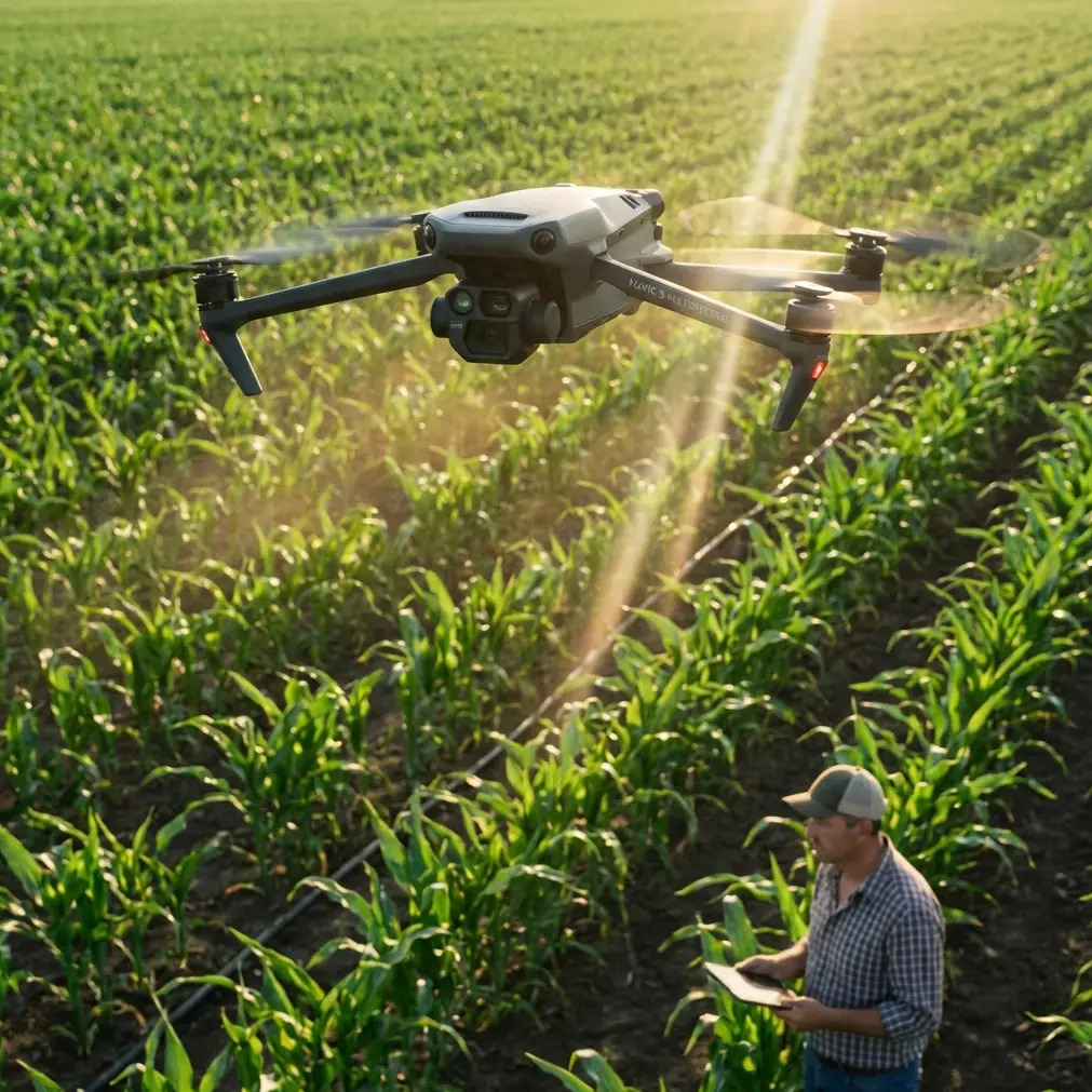
Mavic 3M for Windy Coastline Monitoring: What Actually Changes in the Field
META: A field-focused look at using the DJI Mavic 3M for coastline monitoring in windy conditions, with practical insight on multispectral workflow, training discipline, and power-system implications for UAV operations.
Wind changes everything on the coast.
It changes flight planning, battery confidence, image consistency, and the way small operational mistakes compound over a long survey day. That is why the Mavic 3M deserves a more specific conversation than the usual broad claims about multispectral mapping. If your job is monitoring shorelines, tidal vegetation, erosion patterns, saltmarsh stress, or infrastructure edges near the sea, the question is not simply whether the aircraft can collect data. The question is whether it can do it predictably when the environment keeps trying to break your workflow.
I spend a lot of time with teams that assume coastline work is just inland mapping with better scenery. It is not. Coastal missions put pressure on every weak link: GNSS stability, overlap discipline, battery timing, launch windows, and pilot judgment. The Mavic 3M is compelling here because its value is not only in the multispectral payload. It is in how that payload fits a compact platform that can be deployed quickly when weather windows are short and ground access is messy.
That matters more than people admit.
The real problem: wind turns a clean mapping plan into an inconsistent dataset
On paper, a coastline mission can look straightforward. Draw the polygon, define the swath width, confirm overlap, launch, and let the aircraft work. In practice, coastal wind creates three recurring issues.
First, it stretches flight times. Headwind segments consume more energy than your neat pre-mission estimate suggests. Second, it increases attitude corrections, which can affect image consistency across a long transect. Third, it forces operators to make rushed decisions about when to continue, pause, or cut the mission.
For Mavic 3M users, this has a direct operational consequence: data quality is tied to power discipline as much as to sensor capability. Multispectral outputs are only useful when acquisition stays consistent enough for reliable comparison over time. If you are tracking vegetation stress along dunes or marshes, or looking for recurring change near embankments, the mission has to be repeatable. Wind is what usually attacks repeatability first.
Why the Mavic 3M still makes sense for shoreline work
The Mavic 3M is often discussed through an agriculture lens because multispectral imaging naturally leads people to crop health, plant vigor, and prescription workflows. But those same sensing strengths translate well to coastlines. Not because a beach is a farm, but because shoreline management increasingly depends on differentiating surface conditions, vegetative health, moisture patterns, and change across broad areas.
That is where multispectral imaging stops being a niche feature and becomes a monitoring instrument.
On a windy coast, a compact aircraft has an advantage. You can launch from constrained access points, reposition fast, and exploit narrower weather windows. This is especially helpful in places where tides, public access, or exposed terrain limit how long you can stand up a team. The Mavic 3M is not replacing a large endurance platform for every corridor mission, but it often wins on speed-to-deployment and practical repeatability.
Centimeter precision also matters more near the coast than many first-time operators expect. If your RTK fix rate holds and your control process is disciplined, you can compare datasets over time with far more confidence. That is useful for watching dune retreat, vegetation encroachment, washout recovery, or the changing edge between stable and stressed zones. A coastline rarely fails all at once. It degrades in patterns. The value of Mavic 3M is that it can help reveal those patterns before they become obvious from the ground.
A useful lesson from outside the Mavic 3M world: power systems are becoming the story
One recent industry signal deserves attention. On May 13, ePropelled launched an integrated propulsion and power system designed specifically for agricultural UAVs, aimed at the expanding precision agriculture drone market. At first glance, that seems unrelated to Mavic 3M coastline work. It is not.
The significance is this: power and propulsion are no longer background components. They are becoming strategic differentiators in mission reliability. When a manufacturer introduces an integrated power system specifically for agricultural UAVs, it reflects a broader truth across commercial drone operations. Specialized missions are demanding tighter integration between propulsion efficiency, payload expectations, and operational endurance.
For windy coastline monitoring, that same logic applies even if you are not using that exact system. You need to think like an operator, not just a pilot. Battery swaps, reserve thresholds, return margins, and wind-direction sequencing are not administrative details. They determine whether your multispectral dataset is complete, comparable, and worth processing.
This is also where third-party accessories can genuinely improve outcomes. I have seen teams get better results by adding a well-designed coastal launch and recovery kit, especially portable landing surfaces and transport setups that reduce sand, spray, and debris exposure during repeated sorties. It sounds small until you are cycling several batteries in salt-laden wind. Cleaner turnarounds often preserve tempo, and tempo preserves consistency.
If you are sorting through accessories for a coastal workflow and want a practical second opinion, I usually suggest operators message a specialist here before buying parts that look clever but solve nothing in the field.
The overlooked issue: salt, spray drift, and the wrong kind of confidence
People use the term spray drift in agriculture, but the same thinking helps on the coast. You are not dealing with chemical application, but you are dealing with airborne moisture and fine salt carried laterally by wind. That matters because pilots often underestimate how quickly marine exposure affects equipment handling and maintenance discipline.
An aircraft can survive a hard day and still develop soft problems later.
This is where many teams start overestimating protective ratings or durability assumptions. If you are evaluating companion equipment, cases, landing gear, sensor covers, or field chargers, look at environmental tolerance with the same seriousness you would give to image settings. The Mavic 3M’s success on the coast depends partly on what happens before takeoff and after landing. Corrosion risk, connector cleanliness, and safe battery staging are not glamorous topics, but they are often the difference between a one-off successful mission and a dependable monitoring program.
Training matters more than specifications when the wind comes up
There is an excellent lesson hidden in an unlikely source: a training document on aerobatic model aircraft. It summarizes experience from hundreds of students and recommends practicing each maneuver only 3 to 4 times in sequence before moving on. It also advises grouping training into sets of just 2 to 3 actions rather than trying to master everything in one stretch.
That is deeply relevant to Mavic 3M operations.
Why? Because windy coastline work punishes overloaded pilots. If you try to train flight execution, mission planning, shoreline hazard awareness, RTK checks, camera workflow, and emergency responses all at once, the result is usually mediocre competence across the board. A better method is modular repetition.
Train launch and climbout in coastal wind. Separately train route setup and swath width verification. Separately train battery changeovers and return-to-home decision points. Then combine them into short operational sequences. The old training guidance is blunt and correct: if performance suddenly gets worse, the execution steps themselves are wrong. That applies to drone teams too. When a mission goes ragged halfway through, the answer is usually not “push harder.” It is to step back to the part of the workflow that was actually understood.
The same educational material on drone formations includes a simple but useful sequencing idea: all connected aircraft can be controlled together, or individual units can be triggered by number, with timed intervals such as waiting 5 seconds before initiating a staged landing sequence. For Mavic 3M operators, the direct takeaway is not about flying formation. It is about procedural timing. Windy operations improve when actions are sequenced deliberately rather than reactively.
That may mean:
- waiting a defined interval before committing to the next leg after checking aircraft behavior in gusts
- assigning battery and aircraft states to explicit check steps
- treating post-takeoff stabilization as a mandatory stage, not a casual glance
This sounds basic. It is also where experienced crews separate themselves from hopeful ones.
Building a coastline workflow around the Mavic 3M
A good Mavic 3M coastline workflow starts with mission design that respects the wind instead of pretending it is a constant nuisance to be ignored.
Fly the most energy-demanding legs early, when reserves are strongest. Keep your return path logic conservative. Do not assume the aircraft will come home under the same conditions it left in. Watch RTK fix rate closely if your deliverable depends on centimeter precision over repeated surveys. If fix quality becomes inconsistent, your comparison value over time drops even if the images look fine at first glance.
For vegetation and shoreline condition work, consistency in altitude and overlap matters just as much as spectral capability. If your swath width is too ambitious for the actual wind, your coverage may technically complete while your data becomes harder to trust. A narrower, cleaner mission is usually more valuable than a broad compromised one.
This is also where nozzle calibration offers an instructive analogy from agriculture. Coastline teams are not calibrating sprayers, but they should adopt the same mindset: measure what actually happens, not what the mission plan assumes. In agriculture, poor nozzle calibration distorts application results. In drone mapping, poor calibration of field expectations distorts the dataset. If gusts are changing groundspeed and attitude more than expected, you revise the plan. You do not defend the original settings out of habit.
What the Mavic 3M does best in this environment
The strongest case for the Mavic 3M on windy coasts is not that it ignores environmental difficulty. It is that it gives disciplined operators a compact way to collect high-value multispectral information within short field windows.
That makes it useful for:
- tracking saltmarsh or dune vegetation stress over time
- documenting erosion-prone margins with repeatable geospatial alignment
- monitoring shoreline restoration sites
- inspecting coastal buffer zones where access is awkward or intermittent
- supporting environmental reporting with image data tied to precise location repeatability
Its advantage grows when the team using it understands that successful operations are built from controlled repetition, not bravado.
The bottom line for coastal teams
If your mission profile involves windy shoreline monitoring, the Mavic 3M is best understood as a precision field tool, not a generic camera drone with extra bands. Its multispectral capability is the obvious headline, but the real story is how it performs inside a disciplined workflow shaped around power awareness, repeatable timing, RTK integrity, and field training that is broken into manageable sequences.
Two details from the reference material make that especially clear. The first is ePropelled’s May 13 launch of an integrated power and propulsion system for agricultural UAVs, which signals how seriously the industry now treats mission-specific energy architecture. The second is the training principle drawn from experience with hundreds of learners: practice in short blocks, just 3 to 4 repetitions, and combine only 2 to 3 actions at a time. Those are not random facts. Together, they point to the same operational truth. Specialized UAV work succeeds when technology and method mature together.
For coastline monitoring, that is exactly the mindset the Mavic 3M deserves.
Ready for your own Mavic 3M? Contact our team for expert consultation.