Mavic 3M for Coastal Monitoring in Extreme Temperatures
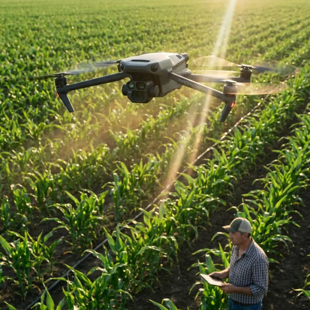
Mavic 3M for Coastal Monitoring in Extreme Temperatures: A Field Case Study from the Edge
META: A real-world case study on using the DJI Mavic 3M for coastal monitoring in extreme temperatures, with practical insight on multispectral workflows, RTK precision, compass reliability, and operational discipline.
The first time I was asked to help design a UAV workflow for coastline monitoring in severe heat swings, the aircraft was only half the problem.
The harder part was trust.
Trust in the data when the shoreline changed week to week. Trust in the positioning when wind, salt, and thermal stress pushed every component a little harder than the brochure conditions. Trust that the images we captured could stand up in front of environmental managers, insurers, and engineering teams who needed more than “looks about right.”
That is why the Mavic 3M has become such a serious tool in this niche. Not because it is fashionable. Because in the field, on long days over exposed coastlines, it removes friction from the jobs that usually go wrong first: repeatability, geospatial consistency, and actionable image interpretation.
This article is built around a practical scenario: monitoring coastlines in extreme temperatures with the Mavic 3M, through the lens of what actually matters when conditions are harsh and timelines are short.
The assignment: monitor change, not just collect pretty maps
A coastal monitoring brief sounds straightforward until you unpack it.
You may need to document dune migration, vegetation stress, erosion pockets, standing water behind berms, access road degradation, and the impact of tidal cycles on adjacent managed land. Sometimes the same program also feeds agriculture, restoration, or drainage planning inland, which is where terms like spray drift, nozzle calibration, swath width, and multispectral vigor mapping suddenly sit in the same conversation as shoreline retreat.
That overlap matters. The Mavic 3M is often discussed as an agricultural platform because of its multispectral capability, but in coastal work, those same sensors become useful for reading plant stress, salt exposure, and recovery patterns across sensitive transition zones. A visible-light map can show where the shoreline moved. A multispectral dataset can help explain what the land is doing in response.
In one project I supported, a client had a recurring problem with manually comparing seasonal surveys. The RGB maps looked sharp, but the team struggled to isolate subtle stress in vegetation buffers that sat between saltwater intrusion and inland management areas. On hot afternoons, ground crews could see signs of change, but they lacked a fast, repeatable way to measure where those changes were expanding.
The Mavic 3M made that process cleaner.
Why the Mavic 3M fits harsh coastal work better than people expect
Coastal monitoring is punishing in a specific way. It combines reflective surfaces, unstable light, persistent wind, salt-laden air, and temperature swings that can skew both hardware behavior and field discipline.
A useful aircraft in this environment needs more than image quality. It needs a workflow that reduces operator error.
That is where the Mavic 3M earns its place. Its value is not just that it captures multispectral data. It is that it allows one team to gather synchronized visual and analytical layers with centimeter-oriented mapping workflows instead of bolting together separate field methods.
When the reader scenario includes RTK Fix rate and centimeter precision, that is not technical window dressing. It is the difference between “we flew the coast again” and “we can defend the observed change over time.”
If you are tracking edge retreat, storm washovers, vegetation dieback, or drainage impacts near shoreline infrastructure, positional repeatability matters as much as the image itself. A map that looks good but drifts between missions creates argument, not evidence.
That is one lesson I learned the hard way years ago with earlier mixed-platform workflows. We were comparing passes flown under difficult field conditions, and small positioning inconsistencies kept turning review meetings into debates. Was that patch truly expanding, or did the model shift? Was the edge movement real, or was it a control issue?
With the Mavic 3M, especially in an RTK-supported workflow, that problem becomes much easier to contain. Better fix stability means cleaner alignment across repeat missions. Cleaner alignment means the multispectral layer can be trusted for trend analysis rather than treated as an interesting visual extra.
Extreme temperatures reveal weak habits quickly
Most flight teams talk about wind. Fewer talk honestly about heat stress and equipment discipline.
In coastline work, extreme temperatures often show up as midday surface heating, prolonged sun exposure on dark equipment cases, and battery management issues that quietly affect consistency. Sensors are one part of that picture, but navigation integrity is another.
One of the most overlooked technical themes in the reference material is compass interference management. The calibration document is not about the Mavic 3M specifically, but the operational lesson is highly relevant: electromagnetic interference and poor calibration discipline can degrade hover quality, return-to-home behavior, and automated mission performance.
That document includes a very practical threshold system. If displayed compass interference is below 30%, performance is considered acceptable, especially for hover, return, and auto modes. Between 31% and 60%, you are in uncertain territory. Above 60%, the recommendation is to move the flight controller away from interference sources or use an external compass solution.
Operationally, that matters because extreme-environment shoreline work often invites exactly the bad habits that create interference risk. Operators set up near vehicles, metal barriers, field generators, temporary pumps, radios, or improvised charging stations. Then they expect clean autonomous mapping performance over water and sand.
That is how avoidable errors get normalized.
Even if your aircraft abstracts much of this from the user compared with an open autopilot stack, the principle remains: geospatial work is only as stable as the electromagnetic and calibration discipline behind it. In my own field checklists, I still borrow that mindset. Before serious coastline missions, I want clean staging, deliberate orientation checks, and a repeatable launch routine away from avoidable interference sources.
The same calibration source gives another detail worth paying attention to: a throttle ramp over roughly 5 to 10 seconds up to 50% to 75%, followed by a return to zero, as part of the compass-current measurement process in that environment. For a commercial reader, the exact procedure is less important than what it teaches. Current draw changes magnetic behavior. The aircraft is not a static object. Electrical loading can alter what the navigation system experiences in real conditions.
For coastal monitoring in heat, where motors, batteries, and onboard electronics are all working under stress, that is not academic. It is a reminder that stable mapping begins before takeoff.
The multispectral advantage is not theoretical at the shoreline
People outside the workflow sometimes assume multispectral data is only useful over farmland. That misses what happens in coastal transition zones.
When I say the Mavic 3M improved one of our shoreline programs, I do not mean it simply produced another map layer. I mean it helped the client stop relying on delayed ground interpretation.
Healthy coastal vegetation, salt-stressed vegetation, oversaturated ground, and recovering restoration strips do not always separate cleanly in RGB imagery, especially under harsh light. A multispectral payload gives you another way to interpret site condition, which is especially valuable when visual signs lag behind physiological stress.
This is where the connection to agriculture becomes practical rather than rhetorical. The same ecosystem of thinking that values spray drift awareness, nozzle calibration, and swath efficiency in crop operations also values early detection and spatial consistency in environmental monitoring. If salt spray is pushing farther inland, or if plant buffers are weakening in strips that correspond to drainage or exposure pathways, you need data that reveals pattern, not just appearance.
The Mavic 3M is strong here because it lets one mission serve multiple stakeholders. Environmental teams can look at stress indicators. Civil teams can evaluate surface changes. Land managers can compare repeat missions with stronger confidence in positional consistency.
That kind of multi-department utility matters even more in a market that is becoming less forgiving.
The industry context explains why tools like this are under pressure to perform
One reference point that seems unrelated at first glance actually says a lot about the broader DJI ecosystem.
Recent market data cited DJI holding a 66.2% share in the action, panoramic, and wearable camera segment, with strong revenue growth but rising pressure on margins. That combination tells us two things. Demand for imaging systems is still expanding, and competition at the top is becoming more operationally intense. Faster product iteration, higher channel investment, and more pressure on execution are replacing easy category growth.
Why does that matter to a Mavic 3M buyer or operator?
Because it suggests a manufacturer environment where image systems, product refinement, and workflow efficiency are no longer optional advantages. They are strategic necessities. In practical terms, users should expect tighter integration, quicker development cycles, and a stronger push toward platforms that solve real field problems rather than merely adding features.
For coastal monitoring professionals, that is a good thing. It means the imaging side of the business is being sharpened by real market pressure. And when those imaging disciplines feed into enterprise aerial tools, the benefit shows up as better reliability, better software cohesion, and fewer weak links between capture and decision-making.
I would not overstate the connection, but I would not ignore it either. A company competing aggressively in imaging does not have the luxury of being casual about sensor relevance.
What changed for our field team after switching
The biggest improvement was not speed. It was confidence.
Before the Mavic 3M, our review sessions often included too much interpretation and not enough decision-making. Ground teams would challenge map timing. Analysts would question whether stress signatures were environmental or procedural. Repeatability was possible, but fragile.
After shifting to a more disciplined Mavic 3M workflow, several things improved at once:
- Repeat shoreline missions aligned more consistently because RTK-supported mapping reduced ambiguity.
- Multispectral outputs helped us detect stressed vegetation corridors earlier than standard visual review alone.
- Flight planning became easier to standardize around target swath width and overlap without sacrificing field portability.
- Teams trusted cross-season comparisons more, which meant faster reporting and fewer site revisits.
That last point is easy to underestimate. Every extra revisit to a remote coastline in difficult temperatures adds labor, transport complexity, and weather exposure. A workflow that gets the dataset right the first time has value well beyond battery endurance.
If you are building a coastline program now, one practical step is to define the mission around questions, not just coverage. Are you trying to measure retreat? Detect ecological stress? Validate restoration? Assess water movement? Support nearby precision land management? The Mavic 3M is most effective when the mission plan, sensor outputs, and deliverables are tied tightly together.
If you want to compare notes on that kind of setup, especially for repeat environmental monitoring programs, you can reach out directly here: message Marcus Rodriguez on WhatsApp.
A final field perspective
The Mavic 3M is not magic. Harsh coastlines still punish sloppy operations. Extreme temperatures still expose weak preflight routines. Salt air still shortens the patience of both equipment and crews.
But this model reduces several of the classic pain points at once.
It gives environmental teams a practical multispectral tool without forcing them into a bulkier aircraft class. It supports the level of positional rigor needed for trend analysis, where RTK Fix rate and centimeter precision are not marketing terms but operational requirements. And it fits a broader reality in which imaging platforms are being pushed by harder market competition to become more efficient and more useful in the field.
If I had to summarize its role in one sentence, I would say this: the Mavic 3M makes coastline monitoring easier not because it simplifies the environment, but because it reduces uncertainty inside the workflow.
That is what good professional UAV systems do. They do not remove complexity from the mission. They help you manage it well enough that the data can carry the argument.
Ready for your own Mavic 3M? Contact our team for expert consultation.